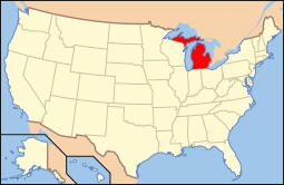
National Register of Historic Places listings in St. Clair County, Michigan
The following is a list of Registered Historic Places in St. Clair County, Michigan.
- This National Park Service list is complete through NPS recent listings posted May 1, 2015.[1]
| [2] | Name on the Register[3] | Image | Date listed[4] | Location | City or town | Description |
|---|---|---|---|---|---|---|
| 1 | Colony Tower Complex | 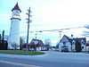 |
(#94000756) |
6503 Dyke Rd. (M-29), Clay Township 42°37′56″N 82°36′12″W / 42.632222°N 82.603333°W |
Pearl Beach | Boundary increase (added 1995-07-21): 6503 Dyke Rd. (MI 29), Clay Township |
| 2 | Wilbur F. Davidson House | 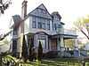 |
(#72001306) |
1707 Military St. 42°57′55″N 82°25′30″W / 42.965278°N 82.425°W |
Port Huron | |
| 3 | Federal Building | .jpg) |
(#74002047) |
526 Water St. 42°58′29″N 82°25′34″W / 42.974722°N 82.426111°W |
Port Huron | |
| 4 | Fort Gratiot | .jpg) |
(#80004069) |
Address Restricted |
Port Huron | |
| 5 | Fort Gratiot Lighthouse | 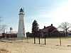 |
(#76001975) |
Omar and Garfield Sts. 43°00′23″N 82°25′21″W / 43.006389°N 82.4225°W |
Port Huron | |
| 6 | Grand Trunk Western Railroad Depot | 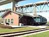 |
(#77001397) |
520 State St. 42°59′55″N 82°25′34″W / 42.998611°N 82.426111°W |
Port Huron | |
| 7 | Harrington Hotel | 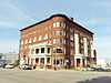 |
(#82004468) |
1026 Military Street 42°58′22″N 82°25′28″W / 42.972778°N 82.424444°W |
Port Huron | |
| 8 | Howard Block | 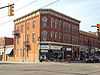 |
(#94000251) |
201-205 Huron Ave. 42°58′35″N 82°25′29″W / 42.976389°N 82.424722°W |
Port Huron | |
| 9 | HURON (lightship) | .jpg) |
(#76001974) |
Pine Grove Park on the St. Clair River 42°59′21″N 82°25′36″W / 42.989167°N 82.426667°W |
Port Huron | |
| 10 | Indian Trail Road-Belle River Bridge | 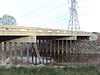 |
(#00000012) |
Indian Trail Rd. over Belle River 42°46′30″N 82°32′58″W / 42.775°N 82.549444°W |
China Township | |
| 11 | Jeddo Road-South Branch Mill Creek Drain Bridge | 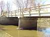 |
(#00000013) |
Jeddo Rd. over S. Branch Mill Creek Drain 43°08′36″N 82°50′13″W / 43.143333°N 82.836944°W |
Brockway Township | |
| 12 | Ladies of the Maccabees Building | 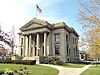 |
(#82004469) |
901 Huron Ave. 42°59′00″N 82°25′29″W / 42.983333°N 82.424722°W |
Port Huron | |
| 13 | Marine City City Hall | 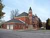 |
(#82004466) |
300 Broadway St. 42°43′12″N 82°29′30″W / 42.72°N 82.491667°W |
Marine City | |
| 14 | Marine City Water Works | 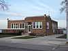 |
(#11000667) |
229 S. Main St. 42°43′03″N 82°29′36″W / 42.7175°N 82.493333°W |
Marine City | |
| 15 | Masters Road-Belle River Bridge | 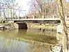 |
(#99001728) |
Masters Rd. over the Belle R. 42°56′24″N 82°49′50″W / 42.939967°N 82.830614°W |
Riley Township | |
| 16 | James McColl House | 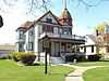 |
(#85000170) |
205 S. Main St. 43°07′36″N 82°47′55″W / 43.126667°N 82.798611°W |
Yale | |
| 17 | Military Road Historic District | 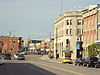 |
(#98001059) |
Military St. and Huron Ave., from Court St. to Bard St. 42°58′34″N 82°25′31″W / 42.976111°N 82.425278°W |
Port Huron | |
| 18 | Seventh Street-Black River Bridge | 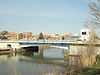 |
(#00000045) |
Seventh St. over the Black River 42°58′34″N 82°25′39″W / 42.976111°N 82.4275°W |
Port Huron | |
| 19 | LeRoy Smith House | 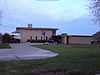 |
(#96000365) |
9503 Frank St. 42°38′31″N 82°30′50″W / 42.641944°N 82.513889°W |
Algonac | |
| 20 | St. Clair Flats South Channel Range Lights | 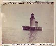 |
(#90000853) |
0.6 mi (0.97 km) west of the southern tip of Harsens Island 42°32′15″N 82°41′41″W / 42.5375°N 82.694722°W |
Algonac | |
| 21 | St. Clair Inn | 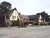 |
(#95000074) |
500 N. Riverside Ave. 42°49′40″N 82°29′04″W / 42.827778°N 82.484444°W |
St. Clair | |
| 22 | St. Clair River Tunnel | .jpg) |
(#70000684) |
St. Clair River between Port Huron, Michigan and Sarnia, Ontario 42°57′30″N 82°24′38″W / 42.958333°N 82.410556°W |
Port Huron | |
| 23 | USCGC Bramble | 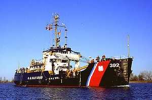 |
(#12000457) |
2336 Military St. 42°57′36″N 82°25′32″W / 42.959979°N 82.42556°W |
Port Huron | |
| 24 | Vernier Street-Swan Creek Bridge | 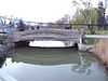 |
(#00000011) |
Vernier St. over Swan Creek 42°40′50″N 82°39′29″W / 42.680556°N 82.658056°W |
Ira Township | |
| 25 | Wadhams Road-Pine River Bridge | 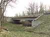 |
(#00000014) |
Wadhams Rd. over the Pine River 42°52′17″N 82°33′28″W / 42.871389°N 82.557778°W |
Saint Clair Township | |
| 26 | Ward-Holland House | 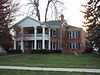 |
(#72001305) |
433 N. Main St. 42°43′26″N 82°29′22″W / 42.723889°N 82.489444°W |
Marine City |
See also
| Wikimedia Commons has media related to National Register of Historic Places in St. Clair County, Michigan. |
- List of Registered Historic Places in Michigan
- List of Michigan State Historic Sites in St. Clair County, Michigan
References
- ↑ "National Register of Historic Places: Weekly List Actions". National Park Service, United States Department of the Interior. Retrieved on May 1, 2015.
- ↑ Numbers represent an ordering by significant words. Various colorings, defined here, differentiate National Historic Landmarks and historic districts from other NRHP buildings, structures, sites or objects.
- ↑ "National Register Information System". National Register of Historic Places. National Park Service. 2008-04-24.
- ↑ The eight-digit number below each date is the number assigned to each location in the National Register Information System database, which can be viewed by clicking the number.
| ||||||||||||

| |||||||||||||||||||||||||

| ||||||||||||||||||||||||||