National Register of Historic Places listings in South Side Chicago
For places listed on the National Register in the rest of Chicago, see National Register of Historic Places listings in North Side Chicago, National Register of Historic Places listings in Central Chicago or National Register of Historic Places listings in West Side Chicago, for Cook County, see National Register of Historic Places listings in Cook County, Illinois.
There are 82 sites on the National Register of Historic Places listings in South Side Chicago, out of 348 listings in the City of Chicago. The South Side is defined for this article as the area west of Lake Michigan and south of 26th Street and the Chicago Sanitary and Ship Canal to the southern Chicago city limits.
| NRHP-listed | |
| ∞ | NRHP-listed Historic district |
| * | National Historic Landmark and NRHP-listed |
| ∞ | National Historic Landmark and NRHP-listed Historic district |
- This National Park Service list is complete through NPS recent listings posted May 1, 2015.[1]
South Side Chicago listings on the National Register
The listed properties are distributed across 19 of the 77 well-defined community areas of Chicago.
| [2] | Name on the Register | Image | Date listed[3] | Location | Neighborhood | Description |
|---|---|---|---|---|---|---|
| 1 | Robert S. Abbott House | 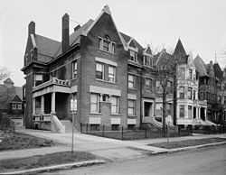 |
(#76000686) |
4742 S. Dr. Martin Luther King Jr. Drive 41°48′36″N 87°36′58″W / 41.81°N 87.616111°W |
Grand Boulevard | Home of Robert S. Abbott, founder of the Chicago Defender newspaper |
| 2 | Armour Square |  |
(#03000789) |
Bounded by W. 33rd Street, W. 34th Place, S. Wells Street and S. Shields Avenue 41°50′01″N 87°38′02″W / 41.833611°N 87.633889°W |
Armour Square | |
| 3 | Auburn Gresham Bungalow Historic District | Upload image | (#12000841) |
Roughly bounded by S. Paulina Street, W. 78th Street, W. 75th Street, & S. Winchester Avenue 41°45′17″N 87°40′08″W / 41.754778°N 87.66901°W |
Auburn Gresham | Part of the Chicago Bungalows Multiple Property Submission (MPS) |
| 4 | AVR 661 | Upload image | (#80001342) |
Calumet Harbor 41°39′43″N 87°34′30″W / 41.661944°N 87.575°W |
South Deering | |
| 5 | Belmonte Flats |  |
(#98000063) |
4257-4259 S. Dr. Martin Luther King Jr. Drive, and 400-412 E. 43rd Street 41°49′01″N 87°36′59″W / 41.816952°N 87.616374°W |
Grand Boulevard | |
| 6 | Calumet Park |  |
(#03000788) |
9801 S. Avenue G 41°43′00″N 87°31′41″W / 41.716667°N 87.528056°W |
East Side | |
| 7 | Chicago Beach Hotel | 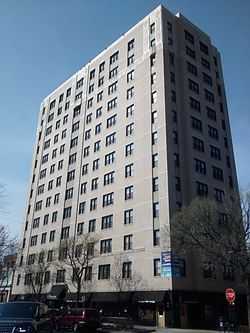 |
(#86001193) |
5100-5110 S. Cornell Avenue 41°48′08″N 87°35′13″W / 41.802222°N 87.586944°W |
Hyde Park | |
| 8 | Chicago Bee Building | 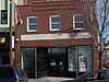 |
(#86001090) |
3647-3655 S. State Street 41°49′41″N 87°37′34″W / 41.828056°N 87.626111°W |
Douglas | |
| 9 | Chrysler Village | 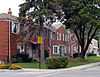 |
(#14000254) |
Bounded by S. Long and S. Lavergne Aves., W. 63rd and W. 56th Sts. 41°46′34″N 87°45′05″W / 41.7759932°N 87.7512806°W |
||
| 10 | Arthur H. Compton House | 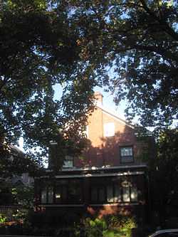 |
(#76000687) |
5637 S. Woodlawn Avenue 41°47′31″N 87°35′47″W / 41.791944°N 87.596389°W |
Hyde Park | |
| 11 | Cornell Square | 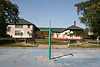 |
(#05000875) |
1809 W. 50th Street 41°48′08″N 87°40′16″W / 41.802222°N 87.671111°W |
New City | |
| 12 | Davis Square | 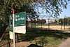 |
(#03000787) |
Roughly bounded by W. 44th Street, W, 45th Street, S. Marshfield Avenue and S. Hemitage Avenue 41°48′47″N 87°40′03″W / 41.813056°N 87.6675°W |
New City | |
| 13 | Oscar Stanton De Priest House | 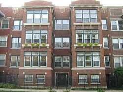 |
(#75000646) |
4536-4538 S. Dr. Martin Luther King, Jr. Drive 41°48′42″N 87°37′05″W / 41.811667°N 87.618056°W |
Grand Boulevard | |
| 14 | Douglas Tomb State Memorial | 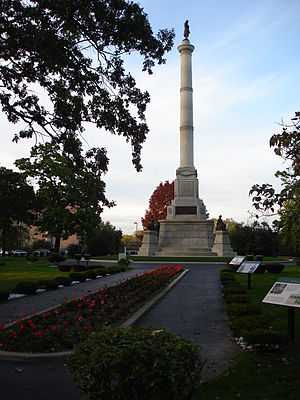 |
(#76000689) |
636 E. 35th Street 41°49′54″N 87°36′30″W / 41.831667°N 87.608333°W |
Douglas | |
| 15 | East Park Towers | 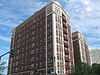 |
(#86001197) |
5236-5252 S. Hyde Park Boulevard 41°47′59″N 87°35′04″W / 41.799722°N 87.584444°W |
Hyde Park | |
| 16 | Eighth Regiment Armory | 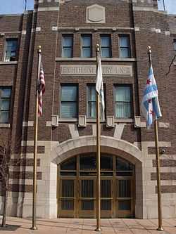 |
(#86001096) |
3533 S. Giles Avenue 41°49′50″N 87°37′10″W / 41.830556°N 87.619444°W |
Douglas | |
| 17 | Site of First Self-Sustaining Nuclear Reaction | 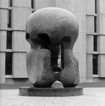 |
(#66000314) |
S. Ellis Avenue between E. 56th Street and 57th Street 41°47′33″N 87°36′04″W / 41.7925°N 87.601111°W |
Hyde Park | |
| 18 | Flamingo-on-the-Lake Apartments | 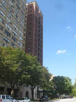 |
(#86001194) |
5500-5520 S. Shore Drive 41°47′41″N 87°34′51″W / 41.794722°N 87.580833°W |
Hyde Park | |
| 19 | Four Nineteen Building |  |
(#99000973) |
419 E. 83rd Street 41°44′37″N 87°36′50″W / 41.74358°N 87.613898°W |
Chatham | |
| 20 | Fuller Park |  |
(#02001347) |
331 W. 45th Street 41°48′46″N 87°38′03″W / 41.812778°N 87.634167°W |
Fuller Park | |
| 21 | Garden Homes Historic District |  |
(#05000108) |
Roughly bounded by S. Wabash Avenue, E. 87th Street, S. Indiana Avenue and E. 89th Street 41°44′11″N 87°37′18″W / 41.736389°N 87.621667°W |
Chatham | |
| 22 | Goldblatt Bros. Department Store | .jpg) |
(#06001016) |
4700 S. Ashland Avenue 41°48′30″N 87°39′55″W / 41.808333°N 87.665278°W |
New City | |
| 23 | Grand Crossing Park |  |
(#06000678) |
7655 S. Ingleside Avenue 41°45′25″N 87°36′01″W / 41.756944°N 87.600278°W |
Greater Grand Crossing | |
| 24 | John W. Griffiths Mansion | 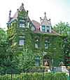 |
(#82002528) |
3806 S. Michigan Avenue 41°49′32″N 87°37′26″W / 41.825556°N 87.623889°W |
Douglas | Also designated a Chicago Landmark under the name Griffiths-Burroughs House |
| 25 | Hamilton Park |  |
(#95000487) |
513 W. 72nd Street 41°45′42″N 87°38′14″W / 41.761667°N 87.637222°W |
Englewood | |
| 26 | Anton E. Hanson House | Upload image | (#06000008) |
7610 S. Ridgeland Avenue 41°45′31″N 87°34′57″W / 41.758611°N 87.5825°W |
South Shore | The Cook County Assessor shows the address as 7608 S. Cleveland |
| 27 | Isadore H. Heller House | _and_North_elevations_-_HABS_ILL%2C16-CHIG%2C48-1.jpg) |
(#72000450) |
5132 S. Woodlawn Avenue 41°48′05″N 87°35′35″W / 41.801389°N 87.593056°W |
Hyde Park | |
| 28 | Charles Hitchcock Hall | 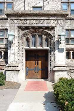 |
(#74000751) |
1009 E. 57th Street 41°47′28″N 87°36′03″W / 41.791111°N 87.600833°W |
Hyde Park | |
| 29 | Hotel Del Prado | 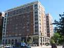 |
(#86001195) |
5307 S. Hyde Park Boulevard 41°47′58″N 87°35′02″W / 41.799444°N 87.583889°W |
Hyde Park | |
| 30 | Hotel Windermere East | 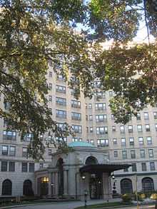 |
(#82000391) |
1642 E. 56th Street 41°47′35″N 87°35′00″W / 41.793056°N 87.583333°W |
Hyde Park | |
| 31 | Hyde Park-Kenwood Historic District | 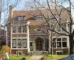 |
(#79000824) |
Roughly bounded by E. 47th Street and E. 59th Street, S. Cottage Grove Avenue and S. Lake Park Avenue; also 821-829 and 816-826 E. 49th Street; also 825-833 and 837-849 E. 52nd Street 41°47′53″N 87°35′51″W / 41.798056°N 87.5975°W |
Hyde Park and Kenwood | Second and third sets of boundaries represent boundary increases of August 16, 1984 and May 16, 1986 respectively |
| 32 | Illinois Institute of Technology Academic Campus |  |
(#05000871) |
Roughly bounded by 31st Street, State Street, 35th Street and the Dan Ryan Expressway 41°50′06″N 87°37′42″W / 41.835°N 87.628333°W |
Douglas | |
| 33 | Jackson Park Historic Landscape District and Midway Plaisance |  |
(#72001565) |
Jackson and Washington Parks and Midway Plaisance roadway 41°46′48″N 87°34′38″W / 41.78°N 87.577222°W |
Hyde Park, Washington Park and Woodlawn | |
| 34 | Jackson Shore Apartments | 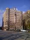 |
(#10000175) |
5490 S. Shore Drive 41°47′44″N 87°34′51″W / 41.7955°N 87.580861°W |
Hyde Park | |
| 35 | Jeffery-Cyril Historic District | Upload image | (#86001007) |
7146-7148, 7128-7138 S. Cyril Avenue, 7144-7148, 7147 and 7130 S. Jeffery Boulevard, and 1966-1974 E. 71st Place 41°45′53″N 87°34′36″W / 41.764722°N 87.576667°W |
South Shore | |
| 36 | Kehilath Anshe Ma'ariv Synagogue | 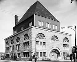 |
(#73000696) |
3301 S. Indiana Avenue 41°50′04″N 87°37′20″W / 41.834444°N 87.622222°W |
Douglas | |
| 37 | Sydney Kent House | 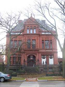 |
(#77000477) |
2944 S. Michigan Avenue 41°50′26″N 87°37′27″W / 41.840556°N 87.624167°W |
Douglas | |
| 38 | Kenwood Evangelical Church | 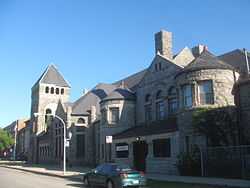 |
(#91000570) |
4600-4608 S. Greenwood Avenue 41°48′41″N 87°36′00″W / 41.811389°N 87.6°W |
Kenwood | |
| 39 | Lake-Side Terrace Apartments |  |
(#84000289) |
7425-7427 S. South Shore Drive 41°45′44″N 87°33′25″W / 41.762222°N 87.556944°W |
South Shore | |
| 40 | Frank R. Lillie House | .jpg) |
(#76000696) |
5801 S. Kenwood Avenue 41°47′22″N 87°35′34″W / 41.789444°N 87.592778°W |
Hyde Park | |
| 41 | Mayfair Apartments |  |
(#86001198) |
1650-1666 E. 56th Street 41°47′43″N 87°35′03″W / 41.795278°N 87.584167°W |
Hyde Park | |
| 42 | Allan Miller House | 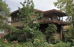 |
(#91001082) |
7121 S. Paxton Avenue 41°45′57″N 87°34′16″W / 41.765833°N 87.571111°W |
South Shore | |
| 43 | Robert A. Millikan House |  |
(#76000699) |
5605 S. Woodlawn Avenue 41°47′34″N 87°35′47″W / 41.792778°N 87.596389°W |
Hyde Park | |
| 44 | The Narragansett | 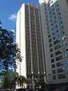 |
(#05000107) |
1640 E. 50th Street 41°48′16″N 87°35′05″W / 41.804444°N 87.584722°W |
Kenwood | |
| 45 | Old Stone Gate of Chicago Union Stockyards | |
(#72000451) |
W. Exchange Avenue & S. Peoria Street 41°49′07″N 87°38′54″W / 41.818611°N 87.648333°W |
New City | |
| 46 | Overton Hygienic Building | 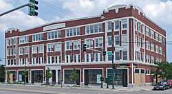 |
(#86001091) |
3619-3627 S. State Street 41°49′41″N 87°37′34″W / 41.828056°N 87.626111°W |
Douglas | |
| 47 | Palmer Park | 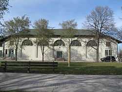 |
(#07000855) |
201 E. 111th Street 41°41′33″N 87°37′06″W / 41.692597°N 87.618228°W |
Roseland | |
| 48 | Parkway Garden Homes | Upload image | (#11000848) |
6330-6546 S. Dr. Martin Luther King Jr Drive 41°46′36″N 87°36′59″W / 41.776667°N 87.616389°W |
Greater Grand Crossing | |
| 49 | Poinsettia Apartments | 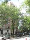 |
(#86001199) |
5528 S. Hyde Park Boulevard 41°47′39″N 87°35′03″W / 41.794167°N 87.584167°W |
Hyde Park | |
| 50 | Promontory Apartments | 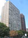 |
(#96001281) |
5530-5532 S. Shore Drive 41°47′39″N 87°34′51″W / 41.794167°N 87.580833°W |
Hyde Park | |
| 51 | Pullman Historic District | .jpg) |
(#69000054) |
Bounded by E. 103rd Street, C.S.S. and S.B. Railroad spur tracks, E. 115th Street and S. Cottage Grove Avenue 41°41′50″N 87°36′34″W / 41.697222°N 87.609444°W |
Pullman | |
| 52 | Ridge Historic District | 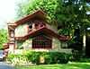 |
(#76000703) |
Roughly bounded by RR tracks, W. 87th Street, S. Prospect Avenue, S. Homewood Avenue, W. 115th Street, S. Lothair Avenue, S. Hamilton Avenue, and S. Western Avenue 41°42′36″N 87°40′13″W / 41.71°N 87.670278°W |
Beverly and Morgan Park | |
| 53 | Frederick C. Robie House | 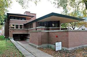 |
(#66000316) |
5757 S. Woodlawn Avenue 41°47′23″N 87°35′45″W / 41.789722°N 87.595833°W |
Hyde Park | |
| 54 | Martin Roche-John Tait House | 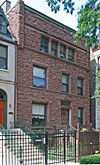 |
(#00001338) |
3614 S. Dr. Martin Luther King Jr. Drive 41°49′46″N 87°37′04″W / 41.829444°N 87.617778°W |
Douglas | |
| 55 | Robert Roloson Houses | .jpg) |
(#77000479) |
3213-3219 S. Calumet Avenue 41°50′08″N 87°37′04″W / 41.835556°N 87.617778°W |
Douglas | |
| 56 | Room 405, George Herbert Jones Laboratory, The University of Chicago |  |
(#67000005) |
S. Ellis Avenue between E. 57th Street and 58th Street 41°47′25″N 87°36′04″W / 41.790278°N 87.601111°W |
Hyde Park | Site of the discovery of Plutonium |
| 57 | Rosenwald Apartment Building | 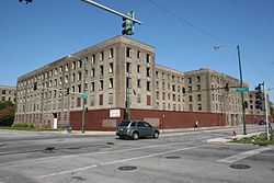 |
(#81000218) |
4618 - 4646 S. Michigan Avenue 41°48′37″N 87°37′26″W / 41.810278°N 87.623889°W |
Grand Boulevard | |
| 58 | S.R. Crown Hall | 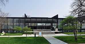 |
(#01001049) |
3360 S. State Street 41°50′01″N 87°37′36″W / 41.833583°N 87.62675°W |
Douglas | |
| 59 | St. Thomas Church and Convent | 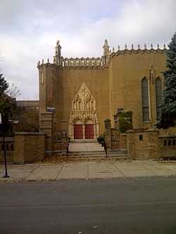 |
(#78001132) |
5472 S. Kimbark Avenue 41°47′44″N 87°35′43″W / 41.795556°N 87.595278°W |
Hyde Park | |
| 60 | Schulze Baking Company Plant | 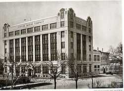 |
(#82000393) |
40 E. Garfield Boulevard 41°47′44″N 87°37′29″W / 41.795556°N 87.624722°W |
Washington Park | |
| 61 | Sherman Park | 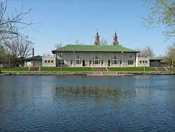 |
(#90000745) |
Bounded by W. 52nd Street, S. Racine Avenue, W. Garfield Boulevard, and S. Loomis Street 41°47′48″N 87°39′18″W / 41.796667°N 87.655°W |
New City | |
| 62 | Shoreland Hotel | 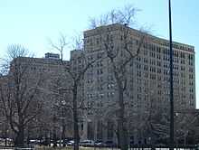 |
(#86001201) |
5450-5484 S. Shore Drive 41°47′45″N 87°34′52″W / 41.795833°N 87.581111°W |
Hyde Park | |
| 63 | South Park Manor Historic District |  |
(#04000076) |
Roughly bounded by S. Dr. Martin Luther King Jr. Drive., S. State Street, E. 75th Street and E. 79th Street 41°45′25″N 87°37′09″W / 41.756944°N 87.619167°W |
Greater Grand Crossing | |
| 64 | South Shore Beach Apartments |  |
(#78001131) |
7321 S. South Shore Drive 41°45′50″N 87°33′34″W / 41.763889°N 87.559444°W |
South Shore | |
| 65 | South Shore Bungalow Historic District | Upload image | (#08001168) |
Bounded roughly by S. Crandon Avenue on the East, E. 78th Street on the South, S. Clyde Avenue on the West, E. 75th Street on the North 41°45′13″N 87°34′07″W / 41.753503°N 87.568661°W |
South Shore | |
| 66 | South Shore Country Club | 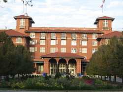 |
(#75000652) |
7059 S. South Shore Drive 41°46′11″N 87°33′46″W / 41.769722°N 87.562778°W |
South Shore | |
| 67 | Spiegel Office Building | 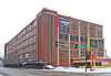 |
(#09000025) |
1038 W. 35th Street 41°49′50″N 87°39′09″W / 41.830556°N 87.6525°W |
Bridgeport | |
| 68 | Stony Island Trust and Savings Bank Building | Upload image | (#13001002) |
6760 S. Stony Island Ave. 41°46′18″N 87°35′12″W / 41.771664°N 87.586722°W |
Greater Grand Crossing | |
| 69 | Strand Hotel | |
(#12001237) |
6315-6323 S. Cottage Grove Avenue 41°46′47″N 87°36′21″W / 41.7796819°N 87.6058915°W |
Woodlawn | |
| 70 | Sutherland Hotel | 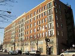 |
(#11000243) |
4659 S. Drexel Boulevard 41°48′35″N 87°36′12″W / 41.809722°N 87.603333°W |
Kenwood | |
| 71 | Swift House | 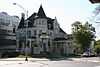 |
(#78001133) |
4500 S. Michigan Avenue 41°48′47″N 87°37′24″W / 41.813056°N 87.623333°W |
Grand Boulevard | |
| 72 | Lorado Taft Midway Studios | .JPG) |
(#66000317) |
6016 S. Ingleside Avenue 41°47′08″N 87°36′13″W / 41.785556°N 87.603611°W |
Woodlawn | |
| 73 | Trumbull Park | 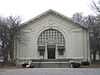 |
(#95000486) |
2400 E. 105th Street 41°42′23″N 87°33′52″W / 41.706389°N 87.564444°W |
South Deering | |
| 74 | U-505 (IX C U-Boat) | 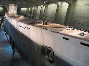 |
(#89001231) |
Jackson Park 41°47′31″N 87°34′55″W / 41.791944°N 87.581944°W |
Hyde Park | |
| 75 | Unity Hall | 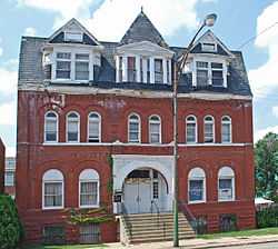 |
(#86001092) |
3140 S. Indiana Avenue 41°50′16″N 87°37′21″W / 41.837778°N 87.6225°W |
Douglas | |
| 76 | University Apartments | 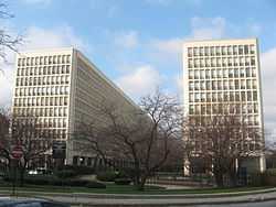 |
(#04001301) |
1401 and 1451 E. 55th Street;1401 and 1450 E. 55th Place 41°47′50″N 87°35′27″W / 41.797222°N 87.590833°W |
Hyde Park | |
| 77 | Victory Sculpture | 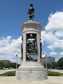 |
(#86001089) |
E. 35th Street at S. Dr. Martin Luther King Jr. Drive 41°49′52″N 87°37′03″W / 41.831111°N 87.6175°W |
Douglas | |
| 78 | Wabash Avenue YMCA | 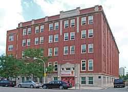 |
(#86001095) |
3763 S. Wabash Avenue 41°49′33″N 87°37′29″W / 41.825833°N 87.624722°W |
Douglas | |
| 79 | Washington Park | |
(#04000871) |
5531 S. Dr. Martin Luther King Jr. Drive 41°47′45″N 87°36′40″W / 41.795833°N 87.611111°W |
Washington Park | |
| 80 | Ida B. Wells-Barnett House | .JPG) |
(#74000757) |
3624 S. Dr. Martin Luther King Jr. Drive 41°49′47″N 87°37′03″W / 41.829722°N 87.6175°W |
Douglas | |
| 81 | West Chatham Bungalow Historic District | 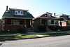 |
(#10000176) |
Bounded roughly by S. Perry Ave on the East, S. 82nd Street on the South, S. Stewart Avenue on the West, and W. 79th Street on the North 41°44′53″N 87°37′50″W / 41.748175°N 87.630578°W |
Chatham | |
| 82 | Dr. Daniel Hale Williams House | 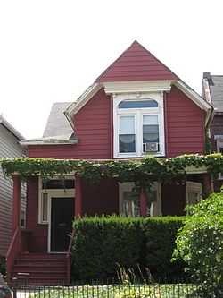 |
(#75000655) |
445 E. 42nd Street 41°49′07″N 87°36′55″W / 41.818611°N 87.615278°W |
Grand Boulevard | |
| 83 | The Yale | 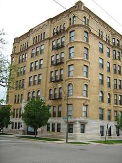 |
(#98000178) |
6565 S. Yale Avenue 41°46′28″N 87°37′53″W / 41.774444°N 87.631389°W |
Englewood |
Former listing
| [2] | Name on the Register | Image | Date listed | Date removed | Location | Summary |
|---|---|---|---|---|---|---|
| 1 | Jordan Building | Upload image | (#86001097) | 3529-3549 S. State St. |
See also
- List of Chicago Landmarks
- List of Registered Historic Places in Illinois
- List of National Historic Landmarks in Illinois
References
- ↑ "National Register of Historic Places: Weekly List Actions". National Park Service, United States Department of the Interior. Retrieved on May 1, 2015.
- ↑ 2.0 2.1 Numbers represent an ordering by significant words. Various colorings, defined here, differentiate National Historic Landmarks and historic districts from other NRHP buildings, structures, sites or objects.
- ↑ The eight-digit number below each date is the number assigned to each location in the National Register Information System database, which can be viewed by clicking the number.
External links
| Wikimedia Commons has media related to National Register of Historic Places in Chicago. |
- Chicago Listing on the National Register of Historic Places, August 5, 2011, City of Chicago, Rahm Emanuel, Mayor.
- NPS Focus database, National Park Service.
| ||||||||||||||||||||||||||