| [3] |
Name on the Register |
Image |
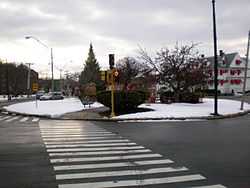
Date listed[4] |
Location |
City or town |
Description |
|---|
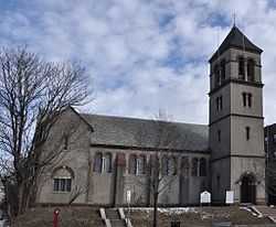
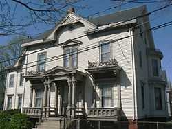
| 1 |
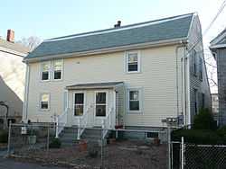
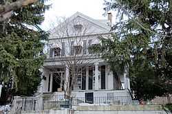
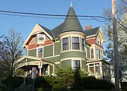
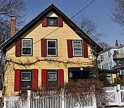
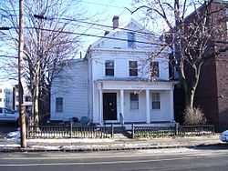
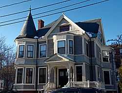
Adams-Magoun House |
|
01989-09-18-0000September 18, 1989
(#89001239) |
438 Broadway
42°23′46″N 71°06′03″W / 42.396111°N 71.100833°W / 42.396111; -71.100833 (Adams-Magoun House) |
Winter Hill |
|
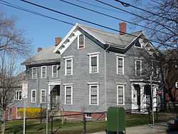
| 2 |
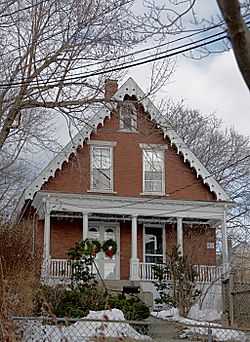
Charles Adams-Woodbury Locke House |
|
01989-09-18-0000September 18, 1989
(#89001240) |
178 Central St.
42°23′39″N 71°05′59″W / 42.394167°N 71.099722°W / 42.394167; -71.099722 (Charles Adams-Woodbury Locke House) |
Winter Hill |
|
| 3 |
Alewife Brook Parkway |
|
02004-03-13-0000March 13, 2004
(#04000249) |
Alewife Brook Parkway
42°24′34″N 71°07′50″W / 42.409556°N 71.130583°W / 42.409556; -71.130583 (Alewife Brook Parkway) |
West Somerville |
Extends into Cambridge
|
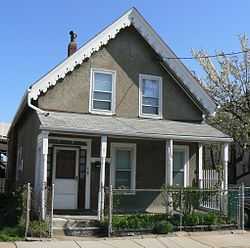
| 4 |
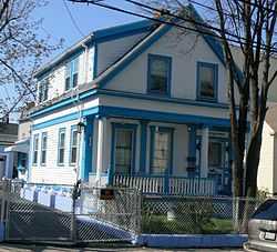
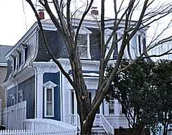
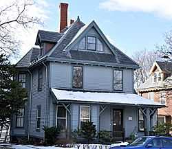
Clifton Bacon House |
|
01989-09-18-0000September 18, 1989
(#89001244) |
27 Chester St.
42°23′39″N 71°07′26″W / 42.394302°N 71.123772°W / 42.394302; -71.123772 (Clifton Bacon House) |
Davis Square |
|
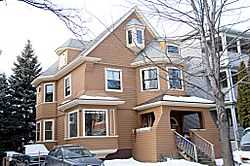
| 5 |
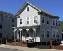
Walter S. and Melissa E. Barnes House |
|
01990-03-08-0000March 8, 1990
(#89001266) |
140 Highland Ave.
42°23′17″N 71°06′12″W / 42.388056°N 71.103333°W / 42.388056; -71.103333 (Walter S. and Melissa E. Barnes House) |
Central Hill |
|
| 6 |
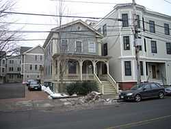
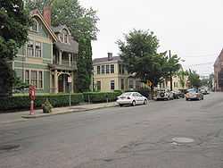
Bow Street Historic District |
|
01976-03-26-0000March 26, 1976
(#76000274) |
Bow St.
42°22′53″N 71°05′54″W / 42.381389°N 71.098333°W / 42.381389; -71.098333 (Bow Street Historic District) |
Union Square |
|
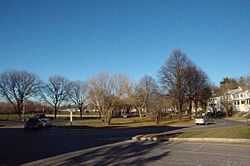
| 7 |
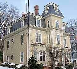
S. E. Brackett House |
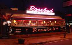
|
01989-09-18-0000September 18, 1989
(#89001252) |
63 Columbus Ave.
42°22′54″N 71°05′43″W / 42.381667°N 71.095278°W / 42.381667; -71.095278 (S. E. Brackett House) |
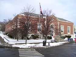
Prospect Hill |
|
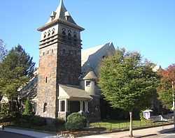
| 8 |
Broadway Winter Hill Congregational Church |
|
01989-09-18-0000September 18, 1989
(#89001238) |
404 Broadway
42°23′42″N 71°05′58″W / 42.395°N 71.099444°W / 42.395; -71.099444 (Broadway Winter Hill Congregational Church) |
Winter Hill |
|
| 9 |
James H. Brooks House |
|
01989-09-18-0000September 18, 1989
(#89001251) |
61 Columbus Ave.
42°22′54″N 71°05′42″W / 42.381667°N 71.095°W / 42.381667; -71.095 (James H. Brooks House) |
Prospect Hill |
|
| 10 |
Martin W. Carr School |
|
01984-07-05-0000July 5, 1984
(#84002530) |
25 Atherton St.
42°23′05″N 71°06′28″W / 42.384722°N 71.107778°W / 42.384722; -71.107778 (Martin W. Carr School) |
Spring Hill |
|
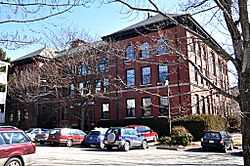
| 11 |
Central Library |
|
01989-09-18-0000September 18, 1989
(#89001274) |
79 Highland Ave.
42°23′09″N 71°05′40″W / 42.385833°N 71.094444°W / 42.385833; -71.094444 (Central Library) |
Central Hill |
|
| 12 |
Z. E. Cliff House |
|
01989-09-18-0000September 18, 1989
(#89001280) |
29 Powder House Terr.
42°23′59″N 71°07′00″W / 42.399689°N 71.116615°W / 42.399689; -71.116615 (Z. E. Cliff House) |
Powder House |
|
| 13 |
Thomas Cook House |
|
01989-09-18-0000September 18, 1989
(#89001250) |
21 College Hill Rd.
42°24′32″N 71°07′44″W / 42.408889°N 71.128889°W / 42.408889; -71.128889 (Thomas Cook House) |
West Somerville |
|
| 14 |
Cooper-Davenport Tavern Wing |
|
01989-09-18-0000September 18, 1989
(#89001257) |
81 Eustis St.
42°23′01″N 71°06′51″W / 42.383611°N 71.114167°W / 42.383611; -71.114167 (Cooper-Davenport Tavern Wing) |
Ward 2 |
|
| 15 |
C. C. Crowell House |
|
01989-09-18-0000September 18, 1989
(#89001236) |
85 Benton Rd.
42°23′23″N 71°06′19″W / 42.389722°N 71.105278°W / 42.389722; -71.105278 (C. C. Crowell House) |
Spring Hill |
|
| 16 |
Downer Rowhouses (Adams Street) |
|
01989-09-18-0000September 18, 1989
(#89001225) |
55 Adams St.
42°23′40″N 71°06′01″W / 42.394444°N 71.100278°W / 42.394444; -71.100278 (Downer Rowhouses (Adams Street)) |
Winter Hill |
|
| 17 |
Downer Rowhouses (Central Street) |
|
01989-09-18-0000September 18, 1989
(#89001241) |
192-200 Central St.
42°23′41″N 71°05′59″W / 42.394722°N 71.099722°W / 42.394722; -71.099722 (Downer Rowhouses (Central Street)) |
Winter Hill |
|
| 18 |
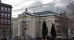
First Unitarian Church |
|
01989-09-18-0000September 18, 1989
(#89001264) |
130 Highland Ave.
42°23′15″N 71°06′07″W / 42.3875°N 71.101944°W / 42.3875; -71.101944 (First Unitarian Church) |
Central Hill |
|
| 19 |
First Universalist Church |
|
01989-09-18-0000September 18, 1989
(#89001262) |
125 Highland Ave.
42°23′15″N 71°06′05″W / 42.3875°N 71.101389°W / 42.3875; -71.101389 (First Universalist Church) |
Central Hill |
|
| 20 |
Alexander Foster House |
|
01989-09-18-0000September 18, 1989
(#89001270) |
45 Laurel St.
42°23′04″N 71°06′15″W / 42.384444°N 71.104167°W / 42.384444; -71.104167 (Alexander Foster House) |
Spring Hill |
|
| 21 |
Samuel Gaut House |
|
01989-09-18-0000September 18, 1989
(#89001265) |
137 Highland Ave.
42°23′17″N 71°06′09″W / 42.388056°N 71.1025°W / 42.388056; -71.1025 (Samuel Gaut House) |
Central Hill |
|
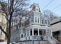
| 22 |
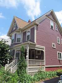
The Grandview |
|
01989-09-18-0000September 18, 1989
(#89001275) |
82 Munroe St.
42°22′56″N 71°05′42″W / 42.382222°N 71.095°W / 42.382222; -71.095 (The Grandview) |
Prospect Hill |
|
| 23 |
The Highland |
|
01989-09-18-0000September 18, 1989
(#89001260) |
66 Highland St.
42°23′13″N 71°05′55″W / 42.386944°N 71.098611°W / 42.386944; -71.098611 (The Highland) |
Central Hill |
|
| 24 |
Hollander Blocks |
|
01989-09-18-0000September 18, 1989
(#89001296) |
Walnut St. and Pleasant Ave.
42°23′02″N 71°05′44″W / 42.383889°N 71.095556°W / 42.383889; -71.095556 (Hollander Blocks) |
Prospect Hill |
|
| 25 |
Elisha Hopkins House |
|
01989-09-18-0000September 18, 1989
(#89001284) |
237 School St.
42°23′31″N 71°05′43″W / 42.391897°N 71.095297°W / 42.391897; -71.095297 (Elisha Hopkins House) |
Winter Hill |
|
| 26 |
House at 10 Arlington Street |
|
01989-09-18-0000September 18, 1989
(#89001230) |
10 Arlington St.
42°23′09″N 71°04′57″W / 42.385833°N 71.0825°W / 42.385833; -71.0825 (House at 10 Arlington Street) |
East Somerville |
|
| 27 |
Houses at 28-36 Beacon Street |
|
01989-09-18-0000September 18, 1989
(#89001232) |
28–36 Beacon St.
42°22′31″N 71°06′12″W / 42.375278°N 71.103333°W / 42.375278; -71.103333 (Houses at 28-36 Beacon Street) |
Inman Square |
|
| 28 |
House at 14 Chestnut Street |
Upload image |
01989-09-18-0000September 18, 1989
(#89001245) |
14 Chestnut St.
42°22′29″N 71°05′11″W / 42.374722°N 71.086389°W / 42.374722; -71.086389 (House at 14 Chestnut Street) |
Brickbottom |
Building demolished
|
| 29 |
House at 25 Clyde Street |
|
01989-09-18-0000September 18, 1989
(#89001247) |
25 Clyde St.
42°23′41″N 71°06′33″W / 42.394691°N 71.109169°W / 42.394691; -71.109169 (House at 25 Clyde Street) |
Magoun Square |
|
| 30 |
House at 72R Dane Street |
|
01989-09-18-0000September 18, 1989
(#89001254) |
72R Dane St.
42°22′34″N 71°06′16″W / 42.376111°N 71.104444°W / 42.376111; -71.104444 (House at 72R Dane Street) |
Perry Park |
|
| 31 |
House at 21 Dartmouth Street |
|
01989-09-18-0000September 18, 1989
(#89001255) |
21 Dartmouth St.
42°23′27″N 71°05′50″W / 42.390833°N 71.097222°W / 42.390833; -71.097222 (House at 21 Dartmouth Street) |
Winter Hill |
|
| 32 |
House at 343 Highland Avenue |
|
01989-09-18-0000September 18, 1989
(#89001267) |
343 Highland Ave.
42°23′39″N 71°06′59″W / 42.394093°N 71.116402°W / 42.394093; -71.116402 (House at 343 Highland Avenue) |
Powder House |
|
| 33 |
House at 6 Kent Court |
|
01989-09-18-0000September 18, 1989
(#89001269) |
6 Kent Ct.
42°22′57″N 71°06′41″W / 42.3825°N 71.111389°W / 42.3825; -71.111389 (House at 6 Kent Court) |
Ward 2 |
|
| 34 |
House at 197 Morrison Avenue |
|
01989-09-18-0000September 18, 1989
(#89001273) |
197 Morrison Ave.
42°23′51″N 71°07′10″W / 42.397518°N 71.119324°W / 42.397518; -71.119324 (House at 197 Morrison Avenue) |
Davis Square |
|
| 35 |
House at 29 Mt. Vernon Street |
|
01989-09-18-0000September 18, 1989
(#89001302) |
29 Mt. Vernon St.
42°23′08″N 71°04′48″W / 42.385556°N 71.08°W / 42.385556; -71.08 (House at 29 Mt. Vernon Street) |
East Somerville |
|
| 36 |
House at 81 Pearl Street |
|
01989-09-18-0000September 18, 1989
(#89001277) |
81 Pearl St.
42°23′05″N 71°05′06″W / 42.384722°N 71.085°W / 42.384722; -71.085 (House at 81 Pearl Street) |
East Somerville |
|
| 37 |
House at 16-18 Preston Road |
|
01989-09-18-0000September 18, 1989
(#89001279) |
16–18 Preston Rd.
42°23′01″N 71°06′08″W / 42.383611°N 71.102222°W / 42.383611; -71.102222 (House at 16-18 Preston Road) |
Spring Hill |
|
| 38 |
House at 5 Prospect Hill |
|
01989-09-18-0000September 18, 1989
(#89001281) |
5 Prospect Hill Avenue
42°22′55″N 71°05′29″W / 42.381944°N 71.091389°W / 42.381944; -71.091389 (House at 5 Prospect Hill) |
Prospect Hill |
|
| 39 |
House at 35 Temple Street |
|
01989-09-18-0000September 18, 1989
(#89001288) |
35 Temple St.
42°23′37″N 71°05′34″W / 42.393611°N 71.092778°W / 42.393611; -71.092778 (House at 35 Temple Street) |
Ten Hills |
|
| 40 |
House at 42 Vinal Avenue |
|
01989-09-18-0000September 18, 1989
(#89001290) |
42 Vinal Ave.
42°23′04″N 71°05′51″W / 42.384444°N 71.0975°W / 42.384444; -71.0975 (House at 42 Vinal Avenue) |
Prospect Hill |
|
| 41 |
House at 49 Vinal Avenue |
|
01989-09-18-0000September 18, 1989
(#89001292) |
49 Vinal Ave.
42°23′05″N 71°05′49″W / 42.384722°N 71.096944°W / 42.384722; -71.096944 (House at 49 Vinal Avenue) |
Prospect Hill |
|
| 42 |
Samuel Ireland House |
|
01989-09-18-0000September 18, 1989
(#89001299) |
117 Washington
42°22′52″N 71°05′15″W / 42.381111°N 71.0875°W / 42.381111; -71.0875 (Samuel Ireland House) |
East Somerville |
|
| 43 |
Joseph K. James House |
|
01998-02-11-0000February 11, 1998
(#98000095) |
83 Belmont St.
42°23′18″N 71°06′30″W / 42.388333°N 71.108333°W / 42.388333; -71.108333 (Joseph K. James House) |
Spring Hill |
|
| 44 |
Amos Keyes House |
|
01989-09-18-0000September 18, 1989
(#89001224) |
12 Adams St.
42°23′37″N 71°06′06″W / 42.393611°N 71.101667°W / 42.393611; -71.101667 (Amos Keyes House) |
Magoun Square |
|
| 45 |
R. A. Knight-Eugene Lacount House |
|
01989-09-18-0000September 18, 1989
(#89001256) |
34 Day St.
42°23′43″N 71°07′26″W / 42.395184°N 71.124023°W / 42.395184; -71.124023 (R. A. Knight-Eugene Lacount House) |
Davis Square |
|
| 46 |
Langmaid Building |
|
01989-09-18-0000September 18, 1989
(#89001259) |
48-52 Highland Ave.
42°23′07″N 71°05′45″W / 42.385278°N 71.095833°W / 42.385278; -71.095833 (Langmaid Building) |
Central Hill |
|
| 47 |
Langmaid Terrace |
|
01989-09-18-0000September 18, 1989
(#89001237) |
359-365 Broadway
42°23′39″N 71°05′47″W / 42.394167°N 71.096389°W / 42.394167; -71.096389 (Langmaid Terrace) |
Ten Hills |
|
| 48 |
Charles H. Lockhardt House |
|
01989-09-18-0000September 18, 1989
(#89001249) |
88 College Ave.
42°23′57″N 71°07′11″W / 42.399235°N 71.119682°W / 42.399235; -71.119682 (Charles H. Lockhardt House) |
Davis Square |
|
| 49 |
George Loring House |
|
01989-09-18-0000September 18, 1989
(#89001263) |
76 Highland Ave.
42°23′10″N 71°05′51″W / 42.386111°N 71.0975°W / 42.386111; -71.0975 (George Loring House) |
Central Hill |
|
| 50 |
A. L. Lovejoy House |
|
01989-09-18-0000September 18, 1989
(#89001297) |
30 Warren Ave.
42°22′53″N 71°05′45″W / 42.381389°N 71.095833°W / 42.381389; -71.095833 (A. L. Lovejoy House) |
Prospect Hill |
|
| 51 |
Middlesex Canal Historic and Archaeological District |
|
02009-11-19-0000November 19, 2009
(#09000936) |
Numerous locations along the historic route of the Middlesex Canal
42°25′02″N 71°07′49″W / 42.4173°N 71.1302°W / 42.4173; -71.1302 (Middlesex Canal Historic and Archaeological District) |
West Somerville
Ten Hills
East Somerville |
Extends into other Middlesex County communities and Boston in Suffolk County.
|
| 52 |
Mt. Vernon Street Historic District |
|
01989-09-18-0000September 18, 1989
(#89001223) |
8-24 Mt. Vernon St.
42°23′08″N 71°04′47″W / 42.385556°N 71.079722°W / 42.385556; -71.079722 (Mt. Vernon Street Historic District) |
East Somerville |
|
| 53 |
Robert Munroe House |
|
01989-09-18-0000September 18, 1989
(#89001294) |
37 Walnut St.
42°22′57″N 71°05′46″W / 42.3825°N 71.096111°W / 42.3825; -71.096111 (Robert Munroe House) |
Prospect Hill |
|
| 54 |
Mystic Pumping Station |
|
01990-01-18-0000January 18, 1990
(#89002255) |
Alewife Brook Parkway
42°24′54″N 71°07′52″W / 42.415°N 71.131111°W / 42.415; -71.131111 (Mystic Pumping Station) |
West Somerville |
Listing duplicates Mystic Water Works, below.
|
| 55 |
Mystic Valley Parkway, Metropolitan Park System of Greater Boston MPS |
|
02006-01-18-0000January 18, 2006
(#05001529) |
Mystic Valley Parkway
42°25′47″N 71°07′49″W / 42.429722°N 71.130278°W / 42.429722; -71.130278 (Mystic Valley Parkway, Metropolitan Park System of Greater Boston MPS) |
West Somerville |
Also in
Arlington
Medford and
Winchester
|
| 56 |
Mystic Water Works |
|
01989-09-18-0000September 18, 1989
(#89001227) |
Alewife Brook Parkway and Capen St.
42°24′54″N 71°07′52″W / 42.415°N 71.131111°W / 42.415; -71.131111 (Mystic Water Works) |
West Somerville |
Listing duplicates Mystic Pumping Station, above.
|
| 57 |
John F. Nichols House |
|
01989-09-18-0000September 18, 1989
(#89001285) |
17 Summit St.
42°24′00″N 71°07′11″W / 42.399906°N 71.119659°W / 42.399906; -71.119659 (John F. Nichols House) |
Davis Square |
|
| 58 |
Louville V. Niles House |
|
01989-09-18-0000September 18, 1989
(#89001276) |
97 Munroe St.
42°22′59″N 71°05′44″W / 42.383056°N 71.095556°W / 42.383056; -71.095556 (Louville V. Niles House) |
Prospect Hill |
|
| 59 |
Louville Niles House |
|
01989-09-18-0000September 18, 1989
(#89001295) |
45 Walnut St.
42°22′59″N 71°05′45″W / 42.383056°N 71.095833°W / 42.383056; -71.095833 (Louville Niles House) |
Prospect Hill |
|
| 60 |
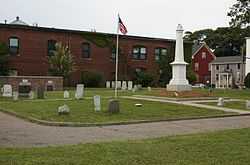
Old Cemetery |
|
01989-09-18-0000September 18, 1989
(#89001301) |
Somerville Ave. and School St.
42°22′53″N 71°06′25″W / 42.381389°N 71.106944°W / 42.381389; -71.106944 (Old Cemetery) |
Union Square |
|
| 61 |
Otis-Wyman House |
|
01989-09-18-0000September 18, 1989
(#89001289) |
67 Thurston St.
42°23′31″N 71°05′51″W / 42.391944°N 71.0975°W / 42.391944; -71.0975 (Otis-Wyman House) |
Winter Hill |
|
| 62 |
Parker-Burnett House |
|
01989-09-18-0000September 18, 1989
(#89001291) |
48 Vinal Ave.
42°23′05″N 71°05′51″W / 42.384722°N 71.0975°W / 42.384722; -71.0975 (Parker-Burnett House) |
Prospect Hill |
|
| 63 |
Powder House Park |
|
01975-04-21-0000April 21, 1975
(#75000287) |
Powder House Circle
42°24′01″N 71°07′02″W / 42.400278°N 71.117222°W / 42.400278; -71.117222 (Powder House Park) |
Powder House |
|
| 64 |
Gustavus G. Prescott House |
|
01989-09-18-0000September 18, 1989
(#89001278) |
65-67 Perkins St.
42°23′03″N 71°04′45″W / 42.384167°N 71.079167°W / 42.384167; -71.079167 (Gustavus G. Prescott House) |
East Somerville |
|
| 65 |
The Rosebud |
|
01999-09-22-0000September 22, 1999
(#99001125) |
381 Summer St.
42°23′40″N 71°07′17″W / 42.394444°N 71.121389°W / 42.394444; -71.121389 (The Rosebud) |
Davis Square |
|
| 66 |
Philemon Russell House |
|
01989-09-18-0000September 18, 1989
(#89001282) |
25 Russell St.
42°23′34″N 71°07′22″W / 42.392738°N 71.122757°W / 42.392738; -71.122757 (Philemon Russell House) |
Davis Square |
|
| 67 |
Susan Russell House |
|
01989-09-18-0000September 18, 1989
(#89001286) |
58 Sycamore St.
42°23′24″N 71°06′04″W / 42.39°N 71.101111°W / 42.39; -71.101111 (Susan Russell House) |
Winter Hill |
|
| 68 |
Charles Schuebeler House |
|
01989-09-18-0000September 18, 1989
(#89001298) |
384 Washington St.
42°22′31″N 71°06′15″W / 42.375278°N 71.104167°W / 42.375278; -71.104167 (Charles Schuebeler House) |
Perry Park |
|
| 69 |
Lemuel Snow, Jr., House |
|
01989-09-18-0000September 18, 1989
(#89001234) |
81 Benton Rd.
42°23′22″N 71°06′20″W / 42.389444°N 71.105556°W / 42.389444; -71.105556 (Lemuel Snow, Jr., House) |
Spring Hill |
|
| 70 |
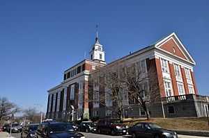
Somerville High School |
|
01989-09-18-0000September 18, 1989
(#89001261) |
93 Highland St.
42°23′13″N 71°05′55″W / 42.386944°N 71.098611°W / 42.386944; -71.098611 (Somerville High School) |
Central Hill |
Building is now the Somerville City Hall
|
| 71 |
Somerville Journal Building |
|
01989-09-18-0000September 18, 1989
(#89001300) |
8-10 Walnut St.
42°22′53″N 71°05′51″W / 42.381389°N 71.0975°W / 42.381389; -71.0975 (Somerville Journal Building) |
Union Square |
|
| 72 |
Somerville Theatre |
|
01990-01-26-0000January 26, 1990
(#89002330) |
55 Davis Sq.
42°23′48″N 71°07′22″W / 42.396763°N 71.122879°W / 42.396763; -71.122879 (Somerville Theatre) |
Davis Square |
|
| 73 |
Spring Hill Historic District |
|
01989-09-18-0000September 18, 1989
(#89001222) |
Roughly bounded by Summer, Central, Atherton, and Spring
42°23′07″N 71°06′29″W / 42.385278°N 71.108056°W / 42.385278; -71.108056 (Spring Hill Historic District) |
Spring Hill |
|
| 74 |
Peter and Oliver Tufts House |
|
01989-09-18-0000September 18, 1989
(#89001287) |
78 Sycamore St.
42°23′27″N 71°06′02″W / 42.390833°N 71.100556°W / 42.390833; -71.100556 (Peter and Oliver Tufts House) |
Winter Hill |
|
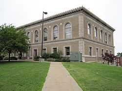
| 75 |
US Post Office-Somerville Main |
|
01986-05-30-0000May 30, 1986
(#86001247) |
237 Washington St.
42°22′47″N 71°05′39″W / 42.379722°N 71.094167°W / 42.379722; -71.094167 (US Post Office-Somerville Main) |
Union Square |
|
| 76 |
H. Warren House |
|
01989-09-18-0000September 18, 1989
(#89001283) |
205 School St.
42°23′25″N 71°05′47″W / 42.390278°N 71.096389°W / 42.390278; -71.096389 (H. Warren House) |
Winter Hill |
|
| 77 |
West Somerville Branch Library |
|
01989-09-18-0000September 18, 1989
(#89001248) |
40 College Ave.
42°23′53″N 71°07′18″W / 42.398067°N 71.121544°W / 42.398067; -71.121544 (West Somerville Branch Library) |
Davis Square |
|
| 78 |
Charles Williams House |
|
01989-09-18-0000September 18, 1989
(#89001253) |
108 Cross St.
42°23′03″N 71°05′22″W / 42.384167°N 71.089444°W / 42.384167; -71.089444 (Charles Williams House) |
East Somerville |
|
| 79 |
Charles Williams, Jr., House |
|
01989-09-18-0000September 18, 1989
(#89001228) |
1 Arlington St.
42°23′09″N 71°04′55″W / 42.385833°N 71.081944°W / 42.385833; -71.081944 (Charles Williams, Jr., House) |
East Somerville |
|
| 80 |
F. G. Williams House |
|
01989-09-18-0000September 18, 1989
(#89001226) |
37 Albion St.
42°23′26″N 71°06′18″W / 42.390556°N 71.105°W / 42.390556; -71.105 (F. G. Williams House) |
Central Hill |
|
| 81 |
Daniel Worthen House |
|
01989-09-18-0000September 18, 1989
(#89001272) |
8 Mt. Pleasant St.
42°23′07″N 71°04′43″W / 42.385278°N 71.078611°W / 42.385278; -71.078611 (Daniel Worthen House) |
East Somerville |
|
| 82 |
Wright House |
|
01989-09-18-0000September 18, 1989
(#89001293) |
54 Vinal Ave.
42°23′06″N 71°05′51″W / 42.385°N 71.0975°W / 42.385; -71.0975 (Wright House) |
Prospect Hill |
|
| 83 |
George Wyatt House |
|
01989-09-18-0000September 18, 1989
(#89001233) |
33 Beacon St.
42°22′31″N 71°06′09″W / 42.375403°N 71.102614°W / 42.375403; -71.102614 (George Wyatt House) |
Inman Square |
|

_Somerville%2C_MA.jpg)
_Somerville%2C_MA.jpg)