National Register of Historic Places listings in Sleeping Bear Dunes National Lakeshore
This is a list of the National Register of Historic Places listings in Sleeping Bear Dunes National Lakeshore.
This is intended to be a complete list of the properties and districts on the National Register of Historic Places in Sleeping Bear Dunes National Lakeshore, Michigan, United States. The locations of National Register properties and districts for which the latitude and longitude coordinates are included below, may be seen in a Google map.[1]
There are eight properties and districts listed on the National Register in the park, one of which is a National Historic Landmark..
- This National Park Service list is complete through NPS recent listings posted May 1, 2015.[2]
Current listings
| [3] |
Name on the Register |
Image |
Date listed[4] |
Location |
City or town |
Description |
|---|
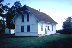
| 1 |
Glen Haven Village Historic District |
|
01983-06-24-0000June 24, 1983
(#83000882) |
M-209
44°53′40″N 86°02′05″W / 44.894444°N 86.034722°W / 44.894444; -86.034722 (Glen Haven Village Historic District) |
Glen Arbor Township |
|
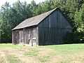
| 2 |
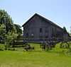
Hutzler's Barn |
|
01978-01-03-0000January 3, 1978
(#78000375) |
West of Leland on South Manitou Island
45°02′16″N 86°06′52″W / 45.037778°N 86.114444°W / 45.037778; -86.114444 (Hutzler's Barn) |
Glen Arbor Township |
|
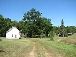
| 3 |
George Conrad Hutzler Farm |
|
01991-05-03-0000May 3, 1991
(#91000466) |
South Manitou Island, Sleeping Bear Dunes National Seashore
45°01′22″N 86°07′36″W / 45.022778°N 86.126667°W / 45.022778; -86.126667 (George Conrad Hutzler Farm) |
Glen Arbor Township |
|
| 4 |
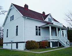
North Manitou Island Lifesaving Station |
|
01998-08-05-0000August 5, 1998
(#98001191) |
East Coast, North Manitou Island
45°07′16″N 85°58′39″W / 45.121111°N 85.9775°W / 45.121111; -85.9775 (North Manitou Island Lifesaving Station) |
Leland Township |
Also known as North Manitou Coast Guard Station
|
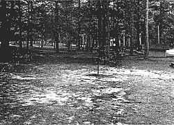
| 5 |
Platte River Campground |
|
01990-04-27-0000April 27, 1990
(#90000605) |
Address Restricted
|
Empire |
|
| 16 |
Port Oneida Rural Historic District |
|
01997-06-27-0000June 27, 1997
(#97000563) |
Roughly bounded by Lake Michigan, Shell Lake, Bass Lake, and Tucker Lake
44°56′14″N 85°56′11″W / 44.937222°N 85.936389°W / 44.937222; -85.936389 (Port Oneida Rural Historic District) |
Cleveland and Glen Arbor Townships |
|
| 6 |
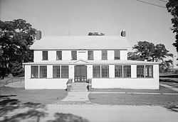
Sleeping Bear Inn |
|
01979-09-06-0000September 6, 1979
(#79000284) |
M-209
44°54′15″N 86°01′38″W / 44.904167°N 86.027222°W / 44.904167; -86.027222 (Sleeping Bear Inn) |
Glen Arbor Township |
|
| 7 |
Sleeping Bear Point Life Saving Station |
|
01979-04-26-0000April 26, 1979
(#79000285) |
North of Glen Haven
44°54′31″N 86°02′01″W / 44.908611°N 86.033611°W / 44.908611; -86.033611 (Sleeping Bear Point Life Saving Station) |
Glen Arbor Township |
|
| 8 |
South Manitou Island Lighthouse Complex and Life Saving Station Historical District |
|
01983-10-28-0000October 28, 1983
(#83003782) |
Sandy Point
45°00′34″N 86°05′35″W / 45.009444°N 86.093056°W / 45.009444; -86.093056 (South Manitou Island Lighthouse Complex and Life Saving Station Historical District) |
Glen Arbor Township |
|
See also
References
- ↑ The latitude and longitude information provided in this table was derived originally from the National Register Information System, which has been found to be fairly accurate for about 99% of listings. For about 1% of NRIS original coordinates, experience has shown that one or both coordinates are typos or otherwise extremely far off; some corrections may have been made. A more subtle problem causes many locations to be off by up to 150 yards, depending on location in the country: most NRIS coordinates were derived from tracing out latitude and longitudes off of USGS topographical quadrant maps created under the North American Datum of 1927, which differs from the current, highly accurate WGS84 GPS system used by most on-line maps. Chicago is about right, but NRIS longitudes in Washington are higher by about 4.5 seconds, and are lower by about 2.0 seconds in Maine. Latitudes differ by about 1.0 second in Florida. Some locations in this table may have been corrected to current GPS standards.
- ↑ "National Register of Historic Places: Weekly List Actions". National Park Service, United States Department of the Interior. Retrieved on May 1, 2015.
- ↑ Numbers represent an ordering by significant words. Various colorings, defined here, differentiate National Historic Landmarks and historic districts from other NRHP buildings, structures, sites or objects.
- ↑ The eight-digit number below each date is the number assigned to each location in the National Register Information System database, which can be viewed by clicking the number.
|
|---|
| | Topics | |
|---|
| | Lists by states | |
|---|
| | Lists by insular areas | |
|---|
| | Lists by associated states | |
|---|
| | Other areas | |
|---|
|
-
 Category Category
-
 Portal Portal
-
 WikiProject WikiProject
|
|