| [3] |
Name on the Register |
Image |
Date listed[4] |
Location |
City or town |
Description |
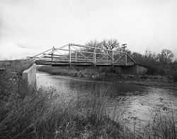
|---|
| 1 |
Big Goose Creek Buffalo Jump |
|
01974-02-12-0000February 12, 1974
(#74002031) |
Address Restricted[5]
|
Sheridan |
|
| 2 |
Big Red Ranch Complex |
Upload image |
01984-10-11-0000October 11, 1984
(#84000437) |
Off U.S. Routes 14/16
44°33′52″N 106°31′37″W / 44.564444°N 106.526944°W / 44.564444; -106.526944 (Big Red Ranch Complex) |
Ucross |
|
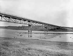
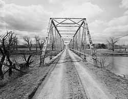
| 3 |
CKW Bridge over Powder River |
|
01985-02-22-0000February 22, 1985
(#85000432) |
U.S. Routes 14/16
44°41′51″N 106°05′58″W / 44.6975°N 106.099444°W / 44.6975; -106.099444 (CKW Bridge over Powder River) |
Arvada |
|
| 4 |
Clearmont Jail |
Upload image |
01984-05-14-0000May 14, 1984
(#84003698) |
Water St.
44°38′20″N 106°22′46″W / 44.638889°N 106.379444°W / 44.638889; -106.379444 (Clearmont Jail) |
Clearmont |
|
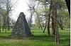
| 5 |
Connor Battlefield |
|
01971-08-12-0000August 12, 1971
(#71000891) |
City park on the Tongue River
44°54′19″N 107°09′43″W / 44.905278°N 107.161944°W / 44.905278; -107.161944 (Connor Battlefield) |
Ranchester |
|
| 6 |
Dayton Community Hall |
Upload image |
02005-11-25-0000November 25, 2005
(#05001338) |
410 Bridge St.
44°52′34″N 107°15′16″W / 44.876111°N 107.254444°W / 44.876111; -107.254444 (Dayton Community Hall) |
Dayton |
|
| 7 |
EAU Arvada Bridge |
|
01985-02-22-0000February 22, 1985
(#85000433) |
County Road CN3-38
44°39′35″N 106°07′48″W / 44.659722°N 106.13°W / 44.659722; -106.13 (EAU Arvada Bridge) |
Arvada |
|
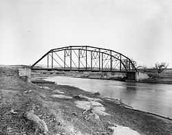
| 8 |
EBF Bridge over Powder River |
|
01985-02-22-0000February 22, 1985
(#85000434) |
County Road CN3-269
44°52′49″N 106°03′41″W / 44.880278°N 106.061389°W / 44.880278; -106.061389 (EBF Bridge over Powder River) |
Leiter |
|
| 9 |
ECR Kooi Bridge |
|
01985-02-22-0000February 22, 1985
(#85000436) |
County Road CN3-93
44°54′33″N 107°05′13″W / 44.909167°N 107.086944°W / 44.909167; -107.086944 (ECR Kooi Bridge) |
Monarch |
|
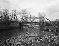
| 10 |
ECS Bridge over Big Goose Creek |
|
01985-02-22-0000February 22, 1985
(#85000435) |
County Road CN3-93
44°44′35″N 107°07′45″W / 44.743056°N 107.129167°W / 44.743056; -107.129167 (ECS Bridge over Big Goose Creek) |
Sheridan |
|
| 11 |
Fort MacKenzie |
Upload image |
01981-06-18-0000June 18, 1981
(#81000612) |
North of Sheridan on Wyoming Highway 337
44°49′39″N 106°58′55″W / 44.8275°N 106.981944°W / 44.8275; -106.981944 (Fort MacKenzie) |
Sheridan |
|
| 12 |
Holy Name Catholic School |
Upload image |
02013-04-23-0000April 23, 2013
(#13000212) |
121 S. Connor St.
44°47′44″N 106°57′05″W / 44.795686°N 106.95136°W / 44.795686; -106.95136 (Holy Name Catholic School) |
Sheridan |
|
| 13 |
Johnson Street Historic District |
Upload image |
01984-04-09-0000April 9, 1984
(#84003701) |
Johnson, 1st, and 2nd Sts.
44°40′49″N 106°59′28″W / 44.680278°N 106.991111°W / 44.680278; -106.991111 (Johnson Street Historic District) |
Big Horn |
|
| 14 |
Mount View |
Upload image |
01997-12-08-0000December 8, 1997
(#97001534) |
610 S. Jefferson St.
44°47′30″N 106°57′40″W / 44.791667°N 106.961111°W / 44.791667; -106.961111 (Mount View) |
Sheridan |
|
| 15 |
Odd Fellows Hall |
Upload image |
01980-12-09-0000December 9, 1980
(#80004052) |
Jackson St.
44°40′46″N 106°59′27″W / 44.679444°N 106.990833°W / 44.679444; -106.990833 (Odd Fellows Hall) |
Big Horn |
|
| 16 |
Quarter Circle A Ranch |
Upload image |
01976-08-10-0000August 10, 1976
(#76001961) |
2 mi (3.2 km) southwest of Big Horn
44°38′26″N 107°00′53″W / 44.640556°N 107.014722°W / 44.640556; -107.014722 (Quarter Circle A Ranch) |
Big Horn |
|
| 17 |
St. Peter's Episcopal Church |
Upload image |
02013-05-08-0000May 8, 2013
(#13000266) |
1 S. Tschirgi
44°47′50″N 106°57′29″W / 44.797096°N 106.958047°W / 44.797096; -106.958047 (St. Peter's Episcopal Church) |
Sheridan |
|
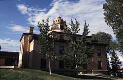
| 18 |
Sheridan County Courthouse |
|
01982-11-15-0000November 15, 1982
(#82001836) |
Burkett and Main St.
44°47′42″N 106°57′21″W / 44.795°N 106.955833°W / 44.795; -106.955833 (Sheridan County Courthouse) |
Sheridan |
|
| 19 |
Sheridan County Fairgrounds Historic District |
Upload image |
02011-08-10-0000August 10, 2011
(#11000533) |
1753 Victoria St.
44°48′16″N 106°58′53″W / 44.804444°N 106.981389°W / 44.804444; -106.981389 (Sheridan County Fairgrounds Historic District) |
Sheridan |
|
| 20 |
Sheridan Flouring Mills, Inc. |
|
01997-12-08-0000December 8, 1997
(#97001533) |
2161 Coffeen Ave.
44°46′28″N 106°56′28″W / 44.774444°N 106.941111°W / 44.774444; -106.941111 (Sheridan Flouring Mills, Inc.) |
Sheridan |
|
| 21 |
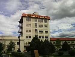
Sheridan Inn |
|
01966-10-15-0000October 15, 1966
(#66000762) |
Broadway and 5th St.
44°48′21″N 106°57′09″W / 44.805833°N 106.9525°W / 44.805833; -106.9525 (Sheridan Inn) |
Sheridan |
|
| 22 |
Sheridan Main Street Historic District |
Upload image |
01982-11-09-0000November 9, 1982
(#82001837) |
Main St. from Burkitt to Mandel Sts.
44°47′55″N 106°57′19″W / 44.798611°N 106.955278°W / 44.798611; -106.955278 (Sheridan Main Street Historic District) |
Sheridan |
|
| 23 |
Sheridan Railroad Historic District |
Upload image |
02004-11-12-0000November 12, 2004
(#04001234) |
201-841 Broadway, 508-955 N. Gould
44°48′19″N 106°57′11″W / 44.805278°N 106.953056°W / 44.805278; -106.953056 (Sheridan Railroad Historic District) |
Sheridan |
|
| 24 |
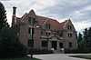
Trail End |
|
01970-02-26-0000February 26, 1970
(#70000675) |
400 Claredon Ave.
44°48′05″N 106°57′58″W / 44.801438°N 106.966190°W / 44.801438; -106.966190 (Trail End) |
Sheridan |
|
| 25 |
Susan Wissler House |
Upload image |
01984-03-08-0000March 8, 1984
(#84003703) |
406 Main St.
44°52′27″N 107°15′43″W / 44.874167°N 107.261944°W / 44.874167; -107.261944 (Susan Wissler House) |
Dayton |
|


.jpg)