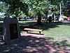
| [3] |
Name on the Register[4] |
Image |
Date listed[5] |
Location |
City or town |
Description |
|---|
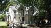
| 1 |
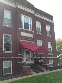
Morton Albaugh House |
Upload image |
02004-04-28-0000April 28, 2004
(#04000366) |
1331 SW. Harrison St.
39°02′31″N 95°40′53″W / 39.041944°N 95.681389°W / 39.041944; -95.681389 (Morton Albaugh House) |
Topeka |
|
| 2 |
Solomon A. Alt House |
Upload image |
02005-03-23-0000March 23, 2005
(#05000202) |
1335 SW. College Ave.
39°02′34″N 95°42′01″W / 39.042778°N 95.700278°W / 39.042778; -95.700278 (Solomon A. Alt House) |
Topeka |
|
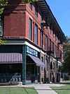
| 3 |
Anton-Woodring House |
Upload image |
01991-08-23-0000August 23, 1991
(#91001088) |
1011 Cambridge Ave.
39°03′03″N 95°43′27″W / 39.050833°N 95.724167°W / 39.050833; -95.724167 (Anton-Woodring House) |
Topeka |
|
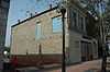
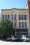
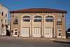
| 4 |
ATSF Motive Power Building |
|
02012-01-20-0000January 20, 2012
(#11001034) |
1001 NE Atchison Ave.
39°03′23″N 95°39′27″W / 39.056297°N 95.657536°W / 39.056297; -95.657536 (ATSF Motive Power Building) |
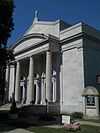
Topeka |
|
| 5 |
Blacksmith Creek Bridge |
Upload image |
01983-03-10-0000March 10, 1983
(#83000441) |
West of Topeka
38°59′48″N 95°50′28″W / 38.996667°N 95.841111°W / 38.996667; -95.841111 (Blacksmith Creek Bridge) |
Topeka |
|
| 6 |
Bowker House |
|
02007-03-15-0000March 15, 2007
(#07000139) |
1200 SE. Quincy
39°02′33″N 95°40′30″W / 39.0425°N 95.675°W / 39.0425; -95.675 (Bowker House) |
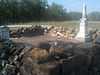
Topeka |
|
| 7 |
Brown v. Board of Education National Historic Site |
|
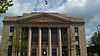
01992-10-26-0000October 26, 1992
(#01000156) |
424 S. Kansas Ave. Suite 220
39°03′15″N 95°40′20″W / 39.054183°N 95.672222°W / 39.054183; -95.672222 (Brown v. Board of Education National Historic Site) |
Topeka |
|
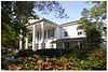
| 8 |
Cedar Crest |
Upload image |
01982-05-06-0000May 6, 1982
(#82002672) |
Cedar Crest Rd.
39°03′56″N 95°44′44″W / 39.065556°N 95.745556°W / 39.065556; -95.745556 (Cedar Crest) |
Topeka |
|
| 9 |
Central Motor and Finance Corporation Building |
Upload image |
01982-02-19-0000February 19, 1982
(#82002673) |
222 W. 7th St.
39°03′02″N 95°40′23″W / 39.050556°N 95.673056°W / 39.050556; -95.673056 (Central Motor and Finance Corporation Building) |
Topeka |
|
| 10 |
Central National Bank |
|
01976-07-19-0000July 19, 1976
(#76000841) |
701-703 Kansas Ave.
39°03′00″N 95°40′26″W / 39.05°N 95.673889°W / 39.05; -95.673889 (Central National Bank) |
Topeka |
|
| 11 |
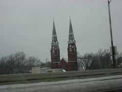
Church of the Assumption and Rectory |
|
02008-07-02-0000July 2, 2008
(#08000607) |
204 SW. 8th St.
39°02′57″N 95°40′34″W / 39.049167°N 95.676111°W / 39.049167; -95.676111 (Church of the Assumption and Rectory) |
Topeka |
|
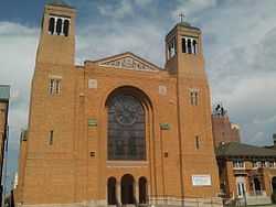
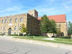
| 12 |
Church of the Holy Name |
|
02012-01-20-0000January 20, 2012
(#11001035) |
1110 SW 10th Ave.
39°02′59″N 95°41′25″W / 39.049769°N 95.690414°W / 39.049769; -95.690414 (Church of the Holy Name) |
Topeka |
|
| 13 |
College Avenue Historic District |
|
02007-04-18-0000April 18, 2007
(#07000321) |
College Ave. between Huntoon St. and 17th St.
39°02′26″N 95°42′01″W / 39.040519°N 95.700375°W / 39.040519; -95.700375 (College Avenue Historic District) |
Topeka |
|
| 14 |
Columbian Building |
|
01975-09-05-0000September 5, 1975
(#75000722) |
112-114 W. 6th St.
39°03′08″N 95°40′26″W / 39.052222°N 95.673889°W / 39.052222; -95.673889 (Columbian Building) |
Topeka |
|
| 15 |
Constitution Hall-Topeka |
|
02008-07-15-0000July 15, 2008
(#08000669) |
429 S. Kansas Ave.
39°03′15″N 95°40′20″W / 39.054167°N 95.672222°W / 39.054167; -95.672222 (Constitution Hall-Topeka) |
Topeka |
|
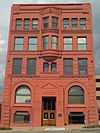
| 16 |
Crawford Building |
|
01975-08-22-0000August 22, 1975
(#75000723) |
501 Jackson St.
39°03′12″N 95°40′26″W / 39.053333°N 95.673889°W / 39.053333; -95.673889 (Crawford Building) |
Topeka |
|
| 17 |
William T. and Delora Crosby House |
|
02011-10-06-0000October 6, 2011
(#11000729) |
1109 SW Topeka Blvd.
39°02′45″N 95°40′58″W / 39.045833°N 95.682778°W / 39.045833; -95.682778 (William T. and Delora Crosby House) |
Topeka |
|
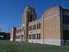
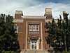
| 18 |
Curtis Junior High School |
Upload image |
02001-10-22-0000October 22, 2001
(#01001126) |
316 NW. Grant St.
39°04′32″N 95°39′59″W / 39.075556°N 95.666389°W / 39.075556; -95.666389 (Curtis Junior High School) |
Topeka |
|
| 19 |
Charles Curtis House |
|
01973-01-25-0000January 25, 1973
(#73000778) |
1101 Topeka Ave.
39°02′45″N 95°40′55″W / 39.045833°N 95.681944°W / 39.045833; -95.681944 (Charles Curtis House) |
Topeka |
|
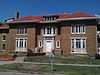
| 20 |
Davies Building |
|
01977-09-15-0000September 15, 1977
(#77000597) |
725-727 Kansas Ave.
39°02′58″N 95°40′27″W / 39.049444°N 95.674167°W / 39.049444; -95.674167 (Davies Building) |
Topeka |
|
| 21 |
Devon Apartments |
|
02002-06-27-0000June 27, 2002
(#02000683) |
800-808 W. 12th St.
39°02′46″N 95°41′11″W / 39.046111°N 95.686389°W / 39.046111; -95.686389 (Devon Apartments) |
Topeka |
|
| 22 |
Dillon House |
|
02006-12-27-0000December 27, 2006
(#06001171) |
404 W. 9th St.
39°02′55″N 95°40′46″W / 39.048611°N 95.679444°W / 39.048611; -95.679444 (Dillon House) |
Topeka |
|
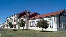
| 23 |
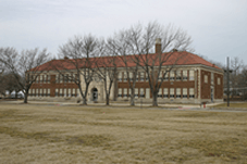
East Topeka Junior High School |
|
02004-01-14-0000January 14, 2004
(#03001397) |
1210 E. 8th St.
39°02′42″N 95°39′36″W / 39.045°N 95.66°W / 39.045; -95.66 (East Topeka Junior High School) |
Topeka |
|
| 24 |
England Farm |
Upload image |
01982-05-07-0000May 7, 1982
(#82002674) |
4619 SE. 37th St.
38°59′58″N 95°35′27″W / 38.999444°N 95.590833°W / 38.999444; -95.590833 (England Farm) |
Topeka |
|
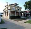
| 25 |
Fire Station No. 2-Topeka |
|
02002-07-03-0000July 3, 2002
(#02000715) |
719-723 Van Buren
39°03′07″N 95°40′35″W / 39.051944°N 95.676389°W / 39.051944; -95.676389 (Fire Station No. 2-Topeka) |
Topeka |
|
| 26 |
Gem Building |
Upload image |
02006-11-01-0000November 1, 2006
(#06000964) |
506-510 SW. 10th Ave.
39°02′58″N 95°40′54″W / 39.049444°N 95.681667°W / 39.049444; -95.681667 (Gem Building) |
Topeka |
|
| 27 |
Giles-Nellis House |
Upload image |
01992-04-28-0000April 28, 1992
(#92000432) |
915 SW. Munson
39°02′50″N 95°41′15″W / 39.047222°N 95.6875°W / 39.047222; -95.6875 (Giles-Nellis House) |
Topeka |
|
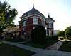
| 28 |
Gordon Building |
Upload image |
02010-10-20-0000October 20, 2010
(#10000846) |
900, 902, and 904 S. Kansas Ave.
39°02′49″N 95°40′30″W / 39.047°N 95.675°W / 39.047; -95.675 (Gordon Building) |
Topeka |
Turn-of-the-20th-century classical revival furniture warehouse significant in Topeka's commercial history[6]
|
| 29 |
Hard Chief's Village |
Upload image |
02007-06-22-0000June 22, 2007
(#07000610) |
Southern side of the Kansas River, west of its confluence with Mission Creek[7]
39°04′24″N 95°51′40″W / 39.073333°N 95.861°W / 39.073333; -95.861 (Hard Chief's Village) |
Silver Lake |
|
| 30 |
John C. Harmon House |
Upload image |
02012-01-20-0000January 20, 2012
(#11001036) |
915 SW Buchanan
39°03′04″N 95°41′30″W / 39.051181°N 95.691764°W / 39.051181; -95.691764 (John C. Harmon House) |
Topeka |
|
| 31 |
Hicks Block |
Upload image |
01977-11-09-0000November 9, 1977
(#77000598) |
600 W. 6th Ave.
39°03′14″N 95°40′48″W / 39.053889°N 95.68°W / 39.053889; -95.68 (Hicks Block) |
Topeka |
|
| 32 |
Holliday Park Historic District I |
|
02002-11-17-0000November 17, 2002
(#02001308) |
Roughly bounded by 10th Ave., Taylor, Polk, Huntoon , Clay and Fillmore Sts.
39°02′45″N 95°41′12″W / 39.045917°N 95.686558°W / 39.045917; -95.686558 (Holliday Park Historic District I) |
Topeka |
|
| 33 |
Holliday Park Historic District II |
Upload image |
02002-11-15-0000November 15, 2002
(#02001309) |
1009, 1015, 1019,1021,1025, 1031, 1035 SW Fillmore St.
39°02′55″N 95°41′20″W / 39.048547°N 95.688992°W / 39.048547; -95.688992 (Holliday Park Historic District II) |
Topeka |
|
| 34 |
Hopkins House |
Upload image |
02009-01-16-0000January 16, 2009
(#08001353) |
6033 SE. U.S. Route 40
39°02′39″N 95°33′23″W / 39.044167°N 95.556389°W / 39.044167; -95.556389 (Hopkins House) |
Tecumseh |
|
| 35 |
Hughes Conoco Service Station |
Upload image |
02011-07-05-0000July 5, 2011
(#11000411) |
400 SW. Taylor St.
39°03′25″N 95°40′54″W / 39.056944°N 95.681667°W / 39.056944; -95.681667 (Hughes Conoco Service Station) |
Topeka |
Roadside Kansas MPS
|
| 36 |
Jayhawk Hotel, Theater and Walk |
|
01982-03-11-0000March 11, 1982
(#82002675) |
700 Jackson Ave.
39°03′01″N 95°40′29″W / 39.050278°N 95.674722°W / 39.050278; -95.674722 (Jayhawk Hotel, Theater and Walk) |
Topeka |
|
| 37 |
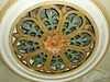
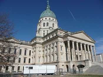
Kansas State Capitol |
|
01971-09-03-0000September 3, 1971
(#71000330) |
Bounded by 8th and 10th Aves. and Jackson and Harrison Sts.
39°02′54″N 95°40′39″W / 39.048333°N 95.6775°W / 39.048333; -95.6775 (Kansas State Capitol) |
Topeka |
|
| 38 |
Fred and Cora Luttjohann House |
|
02004-02-20-0000February 20, 2004
(#03001384) |
2053 S. Kansas Ave.
39°01′53″N 95°40′45″W / 39.031444°N 95.679278°W / 39.031444; -95.679278 (Fred and Cora Luttjohann House) |
Topeka |
|
| 39 |
Horace G. Lyons House |
Upload image |
01984-08-01-0000August 1, 1984
(#84001241) |
4831 SE. 61st St.
38°57′21″N 95°35′02″W / 38.955833°N 95.583889°W / 38.955833; -95.583889 (Horace G. Lyons House) |
Berryton |
|
| 40 |
Masonic Grand Lodge Building |
Upload image |
02014-10-08-0000October 8, 2014
(#14000833) |
320 SW. 8th Ave.
39°03′00″N 95°40′42″W / 39.0501°N 95.6784°W / 39.0501; -95.6784 (Masonic Grand Lodge Building) |
Topeka |
|
| 41 |
McCauley Bridge |
Upload image |
01985-07-02-0000July 2, 1985
(#85001427) |
0.5 miles south of Auburn
38°53′49″N 95°48′53″W / 38.896944°N 95.814722°W / 38.896944; -95.814722 (McCauley Bridge) |
Auburn |
|
| 42 |
Memorial Building |
|
01975-07-17-0000July 17, 1975
(#75000724) |
120 W. 10th Ave.
39°02′47″N 95°40′34″W / 39.046389°N 95.676111°W / 39.046389; -95.676111 (Memorial Building) |
Topeka |
|
| 43 |
Menninger Clinic Building |
Upload image |
01975-02-13-0000February 13, 1975
(#75000725) |
3535 W. 6th Ave.
39°03′30″N 95°43′14″W / 39.058333°N 95.720556°W / 39.058333; -95.720556 (Menninger Clinic Building) |
Topeka |
|
| 44 |
Morgan House |
Upload image |
02004-04-28-0000April 28, 2004
(#04000367) |
1335 SW. Harrison St.
39°02′30″N 95°40′53″W / 39.041667°N 95.681389°W / 39.041667; -95.681389 (Morgan House) |
Topeka |
|
| 45 |
North Topeka Baptist Church |
|
02011-01-18-0000January 18, 2011
(#10001137) |
123 NW Gordon.
39°04′09″N 95°39′59″W / 39.069167°N 95.666389°W / 39.069167; -95.666389 (North Topeka Baptist Church) |
Topeka |
|
| 46 |
Old German-American State Bank |
Upload image |
01980-04-30-0000April 30, 1980
(#80001475) |
435 Kansas Ave.
39°03′06″N 95°40′55″W / 39.051667°N 95.681944°W / 39.051667; -95.681944 (Old German-American State Bank) |
Topeka |
|
| 47 |
Pottawatomie Baptist Mission Building |
Upload image |
01971-09-03-0000September 3, 1971
(#71001089) |
Off W. 6th St., 0.5 mile west of Wanamaker Rd.; also on Urish Rd., 0.3 miles north of 10th St.
39°03′21″N 95°46′31″W / 39.055833°N 95.775278°W / 39.055833; -95.775278 (Pottawatomie Baptist Mission Building) |
Topeka |
Urish Road location represents a boundary increase
|
| 48 |
Potwin Place Historic District |
Upload image |
01980-05-01-0000May 1, 1980
(#80001476) |
Roughly bounded by Elmwood, Grove, Broadmoor, and Willow Sts.
39°03′43″N 95°41′38″W / 39.061944°N 95.693889°W / 39.061944; -95.693889 (Potwin Place Historic District) |
Topeka |
|
| 49 |
Ross Row Houses |
|
01998-11-05-0000November 5, 1998
(#98001329) |
513, 515, 517, 517½, 519, and 521 Van Buren St.
39°03′12″N 95°40′34″W / 39.053333°N 95.676°W / 39.053333; -95.676 (Ross Row Houses) |
Topeka |
|
| 50 |
Sage Inn |
Upload image |
01976-10-08-0000October 8, 1976
(#76000840) |
57th St. and Douglas Rd.
38°57′53″N 95°56′17″W / 38.964722°N 95.938056°W / 38.964722; -95.938056 (Sage Inn) |
Dover |
|
| 51 |
St. John African Methodist Episcopal Church |
Upload image |
02008-08-16-0000August 16, 2008
(#08000987) |
701 SW. Topeka Boulevard
39°03′06″N 95°40′47″W / 39.051667°N 95.679722°W / 39.051667; -95.679722 (St. John African Methodist Episcopal Church) |
Topeka |
|
| 52 |
St. John's Lutheran School |
|
01985-01-03-0000January 3, 1985
(#85000014) |
315 W. 4th St.
39°03′19″N 95°40′32″W / 39.055278°N 95.675556°W / 39.055278; -95.675556 (St. John's Lutheran School) |
Topeka |
|
| 53 |
St. Joseph's Catholic Church |
|
01971-02-24-0000February 24, 1971
(#71000331) |
235 Van Buren St.
39°03′24″N 95°40′29″W / 39.056667°N 95.674722°W / 39.056667; -95.674722 (St. Joseph's Catholic Church) |
Topeka |
|
| 54 |
John Sargent House |
Upload image |
01995-07-28-0000July 28, 1995
(#95000930) |
225 SW. Clay St.
39°03′38″N 95°41′08″W / 39.060556°N 95.685556°W / 39.060556; -95.685556 (John Sargent House) |
Topeka |
|
| 55 |
Security Benefit Association Hospital Building |
Upload image |
02005-11-30-0000November 30, 2005
(#05001341) |
5800 SW. 6th, 5 miles northwest on private road
39°03′45″N 95°45′27″W / 39.0625°N 95.7575°W / 39.0625; -95.7575 (Security Benefit Association Hospital Building) |
Topeka |
|
| 56 |
J.A. Shoemaker House |
Upload image |
02009-01-22-0000January 22, 2009
(#08001354) |
1434 SW. Plass Ave.
39°02′27″N 95°42′17″W / 39.040808°N 95.704619°W / 39.040808; -95.704619 (J.A. Shoemaker House) |
Topeka |
|
| 57 |
Sumner Elementary School and Monroe Elementary School |
|
01987-05-04-0000May 4, 1987
(#87001283) |
330 Western Ave. and 1515 Monroe St.
39°03′29″N 95°40′56″W / 39.058056°N 95.682222°W / 39.058056; -95.682222 (Sumner Elementary School and Monroe Elementary School) |
Topeka |
|
| 58 |
Thacher Building |
Upload image |
01975-03-31-0000March 31, 1975
(#75000726) |
110 E. 8th St.
39°02′56″N 95°40′24″W / 39.048889°N 95.673333°W / 39.048889; -95.673333 (Thacher Building) |
Topeka |
|
| 59 |
Thomas Arch Bridge |
Upload image |
01990-05-10-0000May 10, 1990
(#90000746) |
Junction of Wanamaker Rd. and 105th St. across the Wakarusa River
38°52′30″N 95°45′41″W / 38.875°N 95.761389°W / 38.875; -95.761389 (Thomas Arch Bridge) |
Auburn |
|
| 60 |
Topeka Cemetery-Mausoleum Row |
|
02001-04-25-0000April 25, 2001
(#01000409) |
1601 E. 10th St.
39°02′30″N 95°39′17″W / 39.041667°N 95.654722°W / 39.041667; -95.654722 (Topeka Cemetery-Mausoleum Row) |
Topeka |
|
| 61 |
Topeka Council of Colored Women's Clubs Building |
|
02009-12-30-0000December 30, 2009
(#09001169) |
1149 SW. Lincoln
39°02′51″N 95°41′38″W / 39.047633°N 95.694008°W / 39.047633; -95.694008 (Topeka Council of Colored Women's Clubs Building) |
Topeka |
|
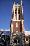
| 62 |
Topeka High School |
|
02005-06-09-0000June 9, 2005
(#05000550) |
800 SW. 10th Ave.
39°03′03″N 95°41′08″W / 39.050833°N 95.685556°W / 39.050833; -95.685556 (Topeka High School) |
Topeka |
|
| 63 |
Union Pacific Railroad Passenger Depot |
|
02002-10-01-0000October 1, 2002
(#02000492) |
701 N. Kansas Ave.
39°03′58″N 95°40′10″W / 39.066111°N 95.669444°W / 39.066111; -95.669444 (Union Pacific Railroad Passenger Depot) |
Topeka |
|
| 64 |
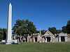
Uniontown Cemetery |
|
02010-05-17-0000May 17, 2010
(#10000263) |
NW Douglas Rd.
39°05′05″N 95°56′15″W / 39.084661°N 95.937522°W / 39.084661; -95.937522 (Uniontown Cemetery) |
Willard |
|
| 65 |
United States Post Office and Court House |
|
02015-03-03-0000March 3, 2015
(#15000046) |
424 S. Kansas Ave.
39°03′13″N 95°40′21″W / 39.0535°N 95.6724°W / 39.0535; -95.6724 (United States Post Office and Court House) |
Topeka |
|
| 66 |
Tinkham Veale Building |
Upload image |
02006-01-11-0000January 11, 2006
(#05001511) |
909-911 S. Kansas Ave.
39°02′49″N 95°40′32″W / 39.046944°N 95.675556°W / 39.046944; -95.675556 (Tinkham Veale Building) |
Topeka |
|
| 67 |
Wakarusa Hotel |
Upload image |
01979-04-26-0000April 26, 1979
(#79000955) |
Main St.
38°53′05″N 95°41′46″W / 38.884722°N 95.696111°W / 38.884722; -95.696111 (Wakarusa Hotel) |
Wakarusa |
|
| 68 |
Ward-Meade House |
|
01975-11-12-0000November 12, 1975
(#75000727) |
124 N. Fillmore
39°03′49″N 95°40′54″W / 39.063611°N 95.681667°W / 39.063611; -95.681667 (Ward-Meade House) |
Topeka |
|
| 69 |
Washburn University Carnegie Library Building |
Upload image |
01987-06-25-0000June 25, 1987
(#87000972) |
Off 17th St. and Washburn Ave.
39°02′08″N 95°42′03″W / 39.035556°N 95.700833°W / 39.035556; -95.700833 (Washburn University Carnegie Library Building) |
Topeka |
|
| 70 |
Wea Creek Bowstring Arch Truss Bridge |
Upload image |
02003-05-09-0000May 9, 2003
(#03000363) |
Grounds of the Kansas State Historical Society, 6425 SE. 6th Ave.
39°03′21″N 95°46′40″W / 39.055833°N 95.777778°W / 39.055833; -95.777778 (Wea Creek Bowstring Arch Truss Bridge) |
Topeka |
|
| 71 |
Westminster Presbyterian Church |
|
02004-05-19-0000May 19, 2004
(#04000453) |
1275 Boswell Ave.
39°02′37″N 95°42′08″W / 39.043611°N 95.702222°W / 39.043611; -95.702222 (Westminster Presbyterian Church) |
Topeka |
|
| 72 |
Willits House |
Upload image |
01997-06-02-0000June 2, 1997
(#97000463) |
1035 SW. Fillmore
39°02′53″N 95°41′27″W / 39.048056°N 95.690833°W / 39.048056; -95.690833 (Willits House) |
Topeka |
|
| 73 |
Woman's Club Building |
|
01982-02-19-0000February 19, 1982
(#82002676) |
420 W. 9th St.
39°02′45″N 95°40′32″W / 39.045833°N 95.675556°W / 39.045833; -95.675556 (Woman's Club Building) |
Topeka |
|
| 74 |
Chester B. Woodward House |
Upload image |
01992-06-25-0000June 25, 1992
(#92000817) |
1272 SW. Fillmore St.
39°02′36″N 95°41′17″W / 39.043333°N 95.688056°W / 39.043333; -95.688056 (Chester B. Woodward House) |
Topeka |
|