National Register of Historic Places listings in Seminole County, Oklahoma

Location of Seminole County in Oklahoma
This is a list of the National Register of Historic Places listings in Seminole County, Oklahoma.
This is intended to be a complete list of the properties on the National Register of Historic Places in Seminole County, Oklahoma, United States. The locations of National Register properties for which the latitude and longitude coordinates are included below, may be seen in a Google map.[1]
There are 16 properties listed on the National Register in the county.
- This National Park Service list is complete through NPS recent listings posted May 1, 2015.[2]
Current listings
| [3] |
Name on the Register[4] |
Image |
Date listed[5] |
Location |
City or town |
Description |
|---|
| 1 |
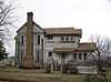
Alice Brown House |
Upload image |
01982-03-31-0000March 31, 1982
(#82003701) |
Chestnut St.
34°56′46″N 96°31′43″W / 34.946111°N 96.528611°W / 34.946111; -96.528611 (Alice Brown House) |
Sasakwa |
|
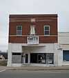
| 2 |
Jackson Brown House |
|
01980-06-27-0000June 27, 1980
(#80003299) |
1200 S. Muskogee Pl.
35°08′53″N 96°29′25″W / 35.1480°N 96.4904°W / 35.1480; -96.4904 (Jackson Brown House) |
Wewoka |
|
| 3 |
Silas L. Brown House |
Upload image |
01985-08-05-0000August 5, 1985
(#85001697) |
107 S. Seminole
35°09′29″N 96°29′12″W / 35.158056°N 96.486667°W / 35.158056; -96.486667 (Silas L. Brown House) |
Wewoka |
|
| 4 |
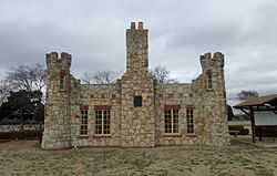
W.E. Grisso Mansion |
|
01975-01-27-0000January 27, 1975
(#75001573) |
612 State Highway 9E
35°14′50″N 96°39′52″W / 35.2471°N 96.6645°W / 35.2471; -96.6645 (W.E. Grisso Mansion) |
Seminole |
|
| 5 |
Home Stake Oil and Gas Company Building |
|
01986-05-14-0000May 14, 1986
(#86001094) |
315 E. Broadway
35°13′27″N 96°40′04″W / 35.2243°N 96.6678°W / 35.2243; -96.6678 (Home Stake Oil and Gas Company Building) |
Seminole |
|
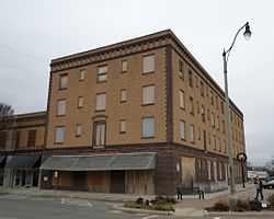
| 6 |
Hotel Aldridge |
|
01986-05-14-0000May 14, 1986
(#86001083) |
3rd St. and Wewoka Ave.
35°09′24″N 96°29′29″W / 35.1568°N 96.4913°W / 35.1568; -96.4913 (Hotel Aldridge) |
Wewoka |
|
| 7 |
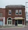
J. Coody Johnson Building |
|
01985-08-05-0000August 5, 1985
(#85001744) |
124 N. Wewoka St.
35°09′35″N 96°29′28″W / 35.1596°N 96.4912°W / 35.1596; -96.4912 (J. Coody Johnson Building) |
Wewoka |
|
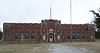
| 8 |
Konawa Armory |
|
01994-05-20-0000May 20, 1994
(#94000483) |
625 N. State St.
34°57′51″N 96°45′05″W / 34.9641°N 96.7513°W / 34.9641; -96.7513 (Konawa Armory) |
Konawa |
|
| 9 |
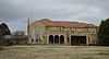
Mekasukey Academy |
Upload image |
01974-03-28-0000March 28, 1974
(#74001668) |
Southwest of Seminole
35°11′25″N 96°43′18″W / 35.190278°N 96.721667°W / 35.190278; -96.721667 (Mekasukey Academy) |
Seminole |
|
| 10 |
Rosenwald Hall |
|
01984-09-28-0000September 28, 1984
(#84003427) |
College St.
35°10′27″N 96°35′56″W / 35.1742°N 96.5988°W / 35.1742; -96.5988 (Rosenwald Hall) |
Lima |
|
| 11 |
Roulston-Rogers Site |
|
01978-11-27-0000November 27, 1978
(#78002262) |
Address Restricted
|
Sasakwa |
|
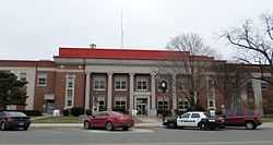
| 12 |
Seminole County Courthouse |
|
01984-08-24-0000August 24, 1984
(#84003429) |
120 S. Wewoka Ave.
35°09′29″N 96°29′27″W / 35.158056°N 96.490833°W / 35.158056; -96.490833 (Seminole County Courthouse) |
Wewoka |
|
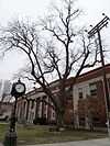
| 13 |
Seminole Whipping Tree |
|
01981-05-22-0000May 22, 1981
(#81000468) |
120 S. Wewoka Ave.
35°09′29″N 96°29′28″W / 35.1581°N 96.4912°W / 35.1581; -96.4912 (Seminole Whipping Tree) |
Wewoka |
|
| 14 |
Sinclair Loading Rack |
Upload image |
01985-08-05-0000August 5, 1985
(#85001698) |
U.S. Route 270
35°12′51″N 96°38′09″W / 35.214167°N 96.635833°W / 35.214167; -96.635833 (Sinclair Loading Rack) |
Seminole |
|
| 15 |
Strother Memorial Chapel |
|
02003-09-02-0000September 2, 2003
(#03000880) |
1201 Van Dr. (inside the Maple Grove Cemetery)
35°14′02″N 96°41′08″W / 35.2340°N 96.6855°W / 35.2340; -96.6855 (Strother Memorial Chapel) |
Seminole |
|
| 16 |
Wewoka Switch and Side Tracks |
|
01985-09-26-0000September 26, 1985
(#85002475) |
State Highway 56
35°09′39″N 96°29′28″W / 35.1609°N 96.4911°W / 35.1609; -96.4911 (Wewoka Switch and Side Tracks) |
Wewoka |
|
See also
References
- ↑ The latitude and longitude information provided in this table was derived originally from the National Register Information System, which has been found to be fairly accurate for about 99% of listings. For about 1% of NRIS original coordinates, experience has shown that one or both coordinates are typos or otherwise extremely far off; some corrections may have been made. A more subtle problem causes many locations to be off by up to 150 yards, depending on location in the country: most NRIS coordinates were derived from tracing out latitude and longitudes off of USGS topographical quadrant maps created under the North American Datum of 1927, which differs from the current, highly accurate WGS84 GPS system used by most on-line maps. Chicago is about right, but NRIS longitudes in Washington are higher by about 4.5 seconds, and are lower by about 2.0 seconds in Maine. Latitudes differ by about 1.0 second in Florida. Some locations in this table may have been corrected to current GPS standards.
- ↑ "National Register of Historic Places: Weekly List Actions". National Park Service, United States Department of the Interior. Retrieved on May 1, 2015.
- ↑ Numbers represent an ordering by significant words. Various colorings, defined here, differentiate National Historic Landmarks and historic districts from other NRHP buildings, structures, sites or objects.
- ↑ "National Register Information System". National Register of Historic Places. National Park Service. 2009-03-13.
- ↑ The eight-digit number below each date is the number assigned to each location in the National Register Information System database, which can be viewed by clicking the number.
|
|---|
| | Topics | |
|---|
| | Lists by states | |
|---|
| | Lists by insular areas | |
|---|
| | Lists by associated states | |
|---|
| | Other areas | |
|---|
|
-
 Category Category
-
 Portal Portal
-
 WikiProject WikiProject
|
|