National Register of Historic Places listings in Seminole County, Florida

Location of Seminole County in Florida
This is a list of the National Register of Historic Places listings in Seminole County, Florida.
This is intended to be a complete list of the properties and districts on the National Register of Historic Places in Seminole County, Florida, United States. The locations of National Register properties and districts for which the latitude and longitude coordinates are included below, may be seen in a Google map.[1]
There are 16 properties and districts listed on the National Register in the county.
- This National Park Service list is complete through NPS recent listings posted May 1, 2015.[2]
Current listings
| [3] |
Name on the Register[4] |
Image |
Date listed[5] |
Location |
City or town |
Description |
|---|
| 1 |
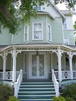
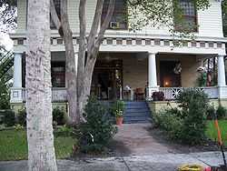
Bradlee-McIntyre House |
|
01991-03-28-0000March 28, 1991
(#72000352) |
130 West Warren Avenue
28°39′50″N 81°22′04″W / 28.663889°N 81.367778°W / 28.663889; -81.367778 (Bradlee-McIntyre House) |
Longwood |
|
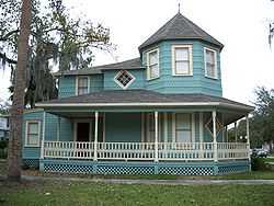
| 2 |
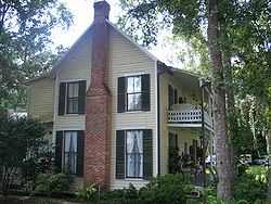
Browne-King House |
|
02001-09-20-0000September 20, 2001
(#01001023) |
322 King Street
28°40′18″N 81°12′50″W / 28.671667°N 81.213889°W / 28.671667; -81.213889 (Browne-King House) |
Oviedo |
|
| 3 |
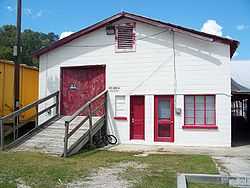
R. W. Estes Celery Company Precooler Historic District |
|
02001-09-20-0000September 20, 2001
(#01001022) |
159 North Central Avenue
28°40′18″N 81°12′33″W / 28.671667°N 81.209167°W / 28.671667; -81.209167 (R. W. Estes Celery Company Precooler Historic District) |
Oviedo |
|
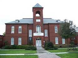
| 4 |
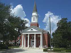
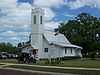
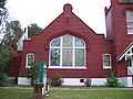
First Methodist Church of Oviedo |
|
02007-07-18-0000July 18, 2007
(#07000743) |
263 King Street
28°40′20″N 81°12′48″W / 28.672222°N 81.213333°W / 28.672222; -81.213333 (First Methodist Church of Oviedo) |
Oviedo |
|
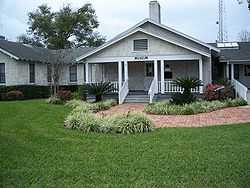
| 5 |
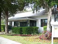
Lake Mary Chamber of Commerce Building |
|
02004-02-11-0000February 11, 2004
(#04000022) |
158 North Country Club Road
28°45′29″N 81°19′21″W / 28.758056°N 81.3225°W / 28.758056; -81.3225 (Lake Mary Chamber of Commerce Building) |
Lake Mary |
|
| 6 |
Longwood Historic District |
|
01990-10-05-0000October 5, 1990
(#90001480) |
Roughly bounded by West Pine Avenue, South Milwee Street, Palmetto Avenue and County Road 427
28°41′57″N 81°20′54″W / 28.699167°N 81.348333°W / 28.699167; -81.348333 (Longwood Historic District) |
Longwood |
|
| 7 |
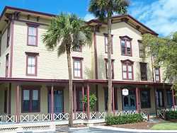
Longwood Hotel |
|
01984-05-10-0000May 10, 1984
(#84000963) |
Old Dixie Highway
28°42′01″N 81°20′52″W / 28.700278°N 81.347778°W / 28.700278; -81.347778 (Longwood Hotel) |
Longwood |
|
| 8 |
Nelson and Company Historic District |
|
02001-09-20-0000September 20, 2001
(#01001010) |
110-166 East Broadway Street and 30-110 Station Street
28°40′05″N 81°32′53″W / 28.668056°N 81.548056°W / 28.668056; -81.548056 (Nelson and Company Historic District) |
Oviedo |
|
| 9 |
Old Fernald-Laughton Memorial Hospital |
|
01987-05-21-0000May 21, 1987
(#87000805) |
500 South Oak Avenue
28°48′27″N 81°16′10″W / 28.8075°N 81.269444°W / 28.8075; -81.269444 (Old Fernald-Laughton Memorial Hospital) |
Sanford |
|
| 10 |
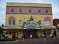
Ritz Theater |
|
02001-01-29-0000January 29, 2001
(#00001130) |
201 South Magnolia Avenue
28°48′37″N 81°16′01″W / 28.810278°N 81.266944°W / 28.810278; -81.266944 (Ritz Theater) |
Sanford |
|
| 11 |
St. James A. M. E. Church |
|
01992-04-24-0000April 24, 1992
(#92000352) |
819 Cypress Avenue
28°48′16″N 81°15′50″W / 28.804444°N 81.263889°W / 28.804444; -81.263889 (St. James A. M. E. Church) |
Sanford |
|
| 12 |
Sanford Commercial District |
|
01976-06-15-0000June 15, 1976
(#76000606) |
Parts of 1st, 2nd, and Commercial Streets, between Palmetto and Oak Streets
28°48′42″N 81°16′03″W / 28.811667°N 81.2675°W / 28.811667; -81.2675 (Sanford Commercial District) |
Sanford |
|
| 13 |
Sanford Grammar School |
|
01984-11-23-0000November 23, 1984
(#84000253) |
7th and Myrtle Streets
28°48′20″N 81°16′15″W / 28.805556°N 81.270833°W / 28.805556; -81.270833 (Sanford Grammar School) |
Sanford |
|
| 14 |
Sanford Residential Historic District |
|
01989-12-15-0000December 15, 1989
(#89002119) |
Roughly bounded by Sanford Avenue, 14th Street, Elm Avenue, and 3rd Street
28°48′17″N 81°16′09″W / 28.804722°N 81.269167°W / 28.804722; -81.269167 (Sanford Residential Historic District) |
Sanford |
|
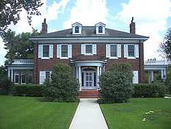
| 15 |
Seminole County Home |
|
01999-06-10-0000June 10, 1999
(#99000696) |
300 Bush Boulevard
28°44′35″N 81°17′58″W / 28.743056°N 81.299444°W / 28.743056; -81.299444 (Seminole County Home) |
Sanford |
|
| 16 |
Wheeler-Evans House |
|
02001-09-20-0000September 20, 2001
(#01001024) |
340 South Lake Jesup Avenue
28°39′57″N 81°12′45″W / 28.665833°N 81.2125°W / 28.665833; -81.2125 (Wheeler-Evans House) |
Oviedo |
|
See also
References
- ↑ The latitude and longitude information provided in this table was derived originally from the National Register Information System, which has been found to be fairly accurate for about 99% of listings. For about 1% of NRIS original coordinates, experience has shown that one or both coordinates are typos or otherwise extremely far off; some corrections may have been made. A more subtle problem causes many locations to be off by up to 150 yards, depending on location in the country: most NRIS coordinates were derived from tracing out latitude and longitudes off of USGS topographical quadrant maps created under the North American Datum of 1927, which differs from the current, highly accurate WGS84 GPS system used by most on-line maps. Chicago is about right, but NRIS longitudes in Washington are higher by about 4.5 seconds, and are lower by about 2.0 seconds in Maine. Latitudes differ by about 1.0 second in Florida. Some locations in this table may have been corrected to current GPS standards.
- ↑ "National Register of Historic Places: Weekly List Actions". National Park Service, United States Department of the Interior. Retrieved on May 1, 2015.
- ↑ Numbers represent an ordering by significant words. Various colorings, defined here, differentiate National Historic Landmarks and historic districts from other NRHP buildings, structures, sites or objects.
- ↑ "National Register Information System". National Register of Historic Places. National Park Service. 2009-03-13.
- ↑ The eight-digit number below each date is the number assigned to each location in the National Register Information System database, which can be viewed by clicking the number.
|
|---|
| | Lists by county | | |
|---|
| | Lists by city | |
|---|
| | Other lists | |
|---|
| |
|