National Register of Historic Places listings in Searcy County, Arkansas
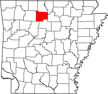
Location of Searcy County in Arkansas
This is a list of the National Register of Historic Places listings in Searcy County, Arkansas.
This is intended to be a complete list of the properties and districts on the National Register of Historic Places in Searcy County, Arkansas, United States. The locations of National Register properties and districts for which the latitude and longitude coordinates are included below, may be seen in a Google map.[1]
There are 49 properties and districts listed on the National Register in the county.
- This National Park Service list is complete through NPS recent listings posted May 1, 2015.[2]
Current listings
| [3] | Name on the Register[4] | Image | Date listed[5] | Location | City or town | Description |
|---|---|---|---|---|---|---|
| 1 | 3SE33 | Upload image | (#76000468) |
Address Restricted |
Silver Hill | |
| 2 | Aday-Stephenson House | Upload image | (#93001365) |
Pine St. 35°54′22″N 92°37′29″W / 35.906111°N 92.624722°W |
Marshall | part of the Searcy County Multiple Property Submission (MPS) |
| 3 | American Legion Post No. 131 | 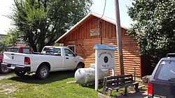 |
(#93001369) |
Center St. west of its junction with Walnut St. 35°49′46″N 92°33′36″W / 35.829444°N 92.56°W |
Leslie | part of the Searcy County MPS |
| 4 | Bank of Marshall Building | Upload image | (#93000974) |
Southeastern corner of the junction of Main and Center Sts. 35°54′33″N 92°37′53″W / 35.909167°N 92.631389°W |
Marshall | part of the Searcy County MPS |
| 5 | Guy Bartley House |  |
(#93001372) |
Northeastern corner of the junction of Elm and 5th Sts. 35°50′02″N 92°33′25″W / 35.833889°N 92.556944°W |
Leslie | part of the Searcy County MPS |
| 6 | Bates Tourist Court | Upload image | (#93000979) |
Fair St. 35°54′39″N 92°37′56″W / 35.910833°N 92.632222°W |
Marshall | part of the Searcy County MPS |
| 7 | Bromley-Mills-Treece House | Upload image | (#93000966) |
Main St. 35°54′32″N 92°37′43″W / 35.908889°N 92.628611°W |
Marshall | part of the Searcy County MPS |
| 8 | Noah Bryan Store | Upload image | (#93000760) |
Southwestern corner of the junction of Glade and Main Sts. 35°54′33″N 92°37′56″W / 35.909167°N 92.632222°W |
Marshall | part of the Searcy County MPS |
| 9 | Campbell Post Office-Kuykendall General Store | Upload image | (#93001364) |
County Road 73 northwest of Oxley 35°52′19″N 92°28′35″W / 35.871944°N 92.476389°W |
Oxley | part of the Searcy County MPS |
| 10 | Dr. Clay House |  |
(#93001368) |
Junction of Walnut and Center Sts. 35°49′46″N 92°33′33″W / 35.829444°N 92.559167°W |
Leslie | part of the Searcy County MPS |
| 11 | Cooper's Bluff | Upload image | (#82002132) |
Address Restricted |
Snowball | part of the Rock Art Sites in Arkansas Thematic Resource (TR) |
| 12 | Dr. J.O. Cotton House | 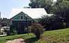 |
(#93001366) |
Southeastern corner of the junction of Highway 66 and High St. 35°49′49″N 92°33′28″W / 35.830278°N 92.557778°W |
Leslie | part of the Searcy County MPS |
| 13 | Dr. Sam G. Daniel House | Upload image | (#93000759) |
Northern side of Nome St., one block west of Courthouse Square 35°54′36″N 92°37′57″W / 35.91°N 92.6325°W |
Marshall | part of the Searcy County MPS |
| 14 | Dugger and Schultz Millinery Store Building | Upload image | (#93000973) |
Southwestern corner of the junction of Glade and Nome Sts. 35°54′35″N 92°37′57″W / 35.909722°N 92.6325°W |
Marshall | part of the Searcy County MPS |
| 15 | Farmers Bank Building | Upload image | (#93000753) |
Junction of Main and Walnut Sts. 35°49′44″N 92°33′35″W / 35.828889°N 92.559722°W |
Leslie | part of the Searcy County MPS |
| 16 | Bud Fendley House | Upload image | (#93000816) |
201 Spring St. 35°54′28″N 92°37′45″W / 35.907778°N 92.629167°W |
Marshall | part of the Searcy County MPS |
| 17 | Ferguson Gas Station | Upload image | (#93000967) |
Southeastern corner of the junction of Center and U.S. Highway 65 35°54′37″N 92°37′52″W / 35.910278°N 92.631111°W |
Marshall | part of the Searcy County MPS |
| 18 | T.M. Ferguson House | Upload image | (#93000972) |
Canaan St. 35°54′29″N 92°38′05″W / 35.908056°N 92.634722°W |
Marshall | part of the Searcy County MPS |
| 19 | Zeb Ferguson House | Upload image | (#93000968) |
U.S. Highway 65 35°54′39″N 92°37′51″W / 35.910833°N 92.630833°W |
Marshall | part of the Searcy County MPS |
| 20 | Gates-Helm Farm | Upload image | (#93000817) |
County Road 13, approximately 1 mile (1.6 km) north of its junction with County Road 250 35°55′16″N 92°50′04″W / 35.921111°N 92.834444°W |
Snowball | part of the Searcy County MPS |
| 21 | Mary Greenhaw Memorial Methodist Episcopal Church South | Upload image | (#12000805) |
115 E. Nome St. 35°54′36″N 92°37′49″W / 35.910004°N 92.630294°W |
Marshall | |
| 22 | Columbus Hatchett House | 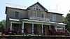 |
(#93000756) |
Northern side of the junction of Main and Hazel Sts. 35°49′40″N 92°33′26″W / 35.827778°N 92.557222°W |
Leslie | part of the Searcy County MPS |
| 23 | Henley Hotel | Upload image | (#10001152) |
112 U.S. Highway 65 North 36°01′47″N 92°48′09″W / 36.029722°N 92.8025°W |
St. Joe | part of the Searcy County MPS |
| 24 | Benjamin Franklin Henley House | Upload image | (#85003070) |
Off U.S. Highway 65 36°02′15″N 92°47′09″W / 36.0375°N 92.785833°W |
St. Joe | |
| 25 | Dr. Cleveland Hollabaugh House | 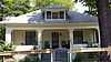 |
(#93001371) |
Oak St. 35°49′56″N 92°33′34″W / 35.832222°N 92.559444°W |
Leslie | part of the Searcy County MPS |
| 26 | S.A. Lay House | Upload image | (#93000971) |
Junction of Glade St. and U.S. Highway 65 35°54′38″N 92°37′55″W / 35.910556°N 92.631944°W |
Marshall | part of the Searcy County MPS |
| 27 | Leslie-Rolen House | 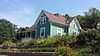 |
(#93000815) |
Junction of Cherry and High Sts. 35°49′48″N 92°33′25″W / 35.83°N 92.556944°W |
Leslie | part of the Searcy County MPS |
| 28 | Anthony Luna House | 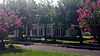 |
(#93000975) |
Southwestern corner of the junction of Main and Spring Sts. 35°54′33″N 92°37′50″W / 35.909167°N 92.630556°W |
Marshall | part of the Searcy County MPS |
| 29 | Thomas Lynch House | Upload image | (#93000757) |
County Road 52, approximately 2.5 miles (4.0 km) north of Morning Star 36°00′18″N 92°35′52″W / 36.005°N 92.597778°W |
Morning Star | part of the Searcy County MPS |
| 30 | Sam Marshall House | Upload image | (#93000980) |
County Road 163 35°58′14″N 92°35′05″W / 35.970556°N 92.584722°W |
Morning Star | part of the Searcy County MPS |
| 31 | William P. and Rosa Lee Martin Farm | Upload image | (#11000356) |
7429 Campbell Rd. 35°56′04″N 92°28′26″W / 35.934444°N 92.473889°W |
Marshall vicinity | |
| 32 | Mays General Store | Upload image | (#83001166) |
Front St. 35°59′20″N 92°42′57″W / 35.988889°N 92.715833°W |
Gilbert | |
| 33 | J.M. McCall House | Upload image | (#93000970) |
Spring St. 35°54′18″N 92°37′46″W / 35.905°N 92.629444°W |
Marshall | part of the Searcy County MPS |
| 34 | Vinie McCall House | Upload image | (#93000969) |
Spring St. 35°54′20″N 92°37′45″W / 35.905556°N 92.629167°W |
Marshall | part of the Searcy County MPS |
| 35 | Meek Building | 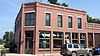 |
(#00001367) |
Junction of Main and Oak Sts. 35°49′47″N 92°33′36″W / 35.829722°N 92.56°W |
Leslie | |
| 36 | J.C. Miller House | 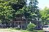 |
(#93001370) |
Northwestern corner of the junction of Oak and High Sts. 35°49′56″N 92°33′34″W / 35.832222°N 92.559444°W |
Leslie | part of the Searcy County MPS |
| 37 | Missouri and North Arkansas Depot-Leslie | 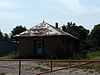 |
(#92000613) |
Southwestern end of Walnut St. 35°49′38″N 92°33′32″W / 35.827222°N 92.558889°W |
Leslie | part of the Historic Railroad Depots of Arkansas MPS |
| 38 | Old Searcy County Jail |  |
(#10000290) |
Highway 27 (Center St.) 35°54′35″N 92°37′54″W / 35.9096°N 92.6318°W |
Marshall | |
| 39 | Charley Passmore House | Upload image | (#93000978) |
Campus St. 35°54′19″N 92°37′56″W / 35.905278°N 92.632222°W |
Marshall | part of the Searcy County MPS |
| 40 | Oscar Redman Building | Upload image | (#93000758) |
119 E. Main St. 35°54′34″N 92°37′52″W / 35.909444°N 92.631111°W |
Marshall | part of the Searcy County MPS |
| 41 | W.F. Reeves House | Upload image | (#93000977) |
Short St. 35°54′48″N 92°38′02″W / 35.913333°N 92.633889°W |
Marshall | part of the Searcy County MPS |
| 42 | Dr. Robinson House | Upload image | (#93001367) |
Walnut St. east of its junction with Center St. 35°49′46″N 92°33′31″W / 35.829444°N 92.558611°W |
Leslie | part of the Searcy County MPS |
| 43 | St. Joe Missouri and North Arkansas Railroad Depot | Upload image | (#93000988) |
Southern side of U.S. Highway 65 36°01′47″N 92°48′09″W / 36.029722°N 92.8025°W |
St. Joe | part of the Historic Railroad Depots of Arkansas MPS |
| 44 | Sanders-Hollabaugh House | Upload image | (#93000976) |
Church St. 35°54′39″N 92°37′47″W / 35.910833°N 92.629722°W |
Marshall | part of the Searcy County MPS |
| 45 | Searcy County Courthouse | 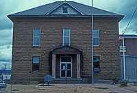 |
(#76000467) |
Courthouse Sq. 35°54′34″N 92°37′55″W / 35.909444°N 92.631944°W |
Marshall | |
| 46 | Greene Thomas House | Upload image | (#93000755) |
West of County Road 55, 0.25 miles (0.40 km) south of its junction with County Road 74 35°51′32″N 92°33′58″W / 35.858889°N 92.566111°W |
Leslie | part of the Searcy County MPS |
| 47 | Treat Commercial Building |  |
(#93000752) |
Northwestern side of Oak St. between High and 4th Sts. 35°49′49″N 92°33′36″W / 35.830278°N 92.56°W |
Leslie | part of the Searcy County MPS |
| 48 | Jasper E. Treece Building | Upload image | (#93000754) |
West of County Road 55, approximately 0.5 miles (0.80 km) south of its junction with Highway 74 35°54′21″N 92°29′05″W / 35.905833°N 92.484722°W |
Baker | part of the Searcy County MPS |
| 49 | Willmering Tourist Cabins Historic District | Upload image | (#00001361) |
U.S. Highway 65 35°58′09″N 92°44′52″W / 35.969167°N 92.747778°W |
Silver Hill | part of the Arkansas Highway History and Architecture MPS |
Former listings
| [3] | Name on the Register | Image | Date listed/removed | Location | City or town | Summary |
|---|---|---|---|---|---|---|
| 1 | Searcy City Hall | Upload image | (#91001227) |
Junction of Gum and Race Streets |
Searcy |
See also
| Wikimedia Commons has media related to National Register of Historic Places in Searcy County, Arkansas. |
- List of National Historic Landmarks in Arkansas
- National Register of Historic Places listings in Arkansas
References
- ↑ The latitude and longitude information provided in this table was derived originally from the National Register Information System, which has been found to be fairly accurate for about 99% of listings. For about 1% of NRIS original coordinates, experience has shown that one or both coordinates are typos or otherwise extremely far off; some corrections may have been made. A more subtle problem causes many locations to be off by up to 150 yards, depending on location in the country: most NRIS coordinates were derived from tracing out latitude and longitudes off of USGS topographical quadrant maps created under the North American Datum of 1927, which differs from the current, highly accurate WGS84 GPS system used by most on-line maps. Chicago is about right, but NRIS longitudes in Washington are higher by about 4.5 seconds, and are lower by about 2.0 seconds in Maine. Latitudes differ by about 1.0 second in Florida. Some locations in this table may have been corrected to current GPS standards.
- ↑ "National Register of Historic Places: Weekly List Actions". National Park Service, United States Department of the Interior. Retrieved on May 1, 2015.
- ↑ 3.0 3.1 Numbers represent an ordering by significant words. Various colorings, defined here, differentiate National Historic Landmarks and historic districts from other NRHP buildings, structures, sites or objects.
- ↑ "National Register Information System". National Register of Historic Places. National Park Service. 2009-03-13.
- ↑ The eight-digit number below each date is the number assigned to each location in the National Register Information System database, which can be viewed by clicking the number.
| ||||||||||||||||||||||||||
| |||||||||||||||||||||||||||||