| [3] |
Name on the Register[4] |
Image |
Date listed[5] |
Location |
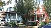
City or town |
Description |
|---|
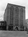
| 1 |
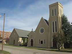
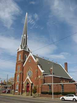
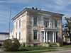
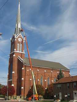
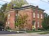
All Saints Episcopal Church |
|
01982-03-25-0000March 25, 1982
(#82003639) |
4th and Court Sts.
38°43′59″N 83°00′02″W / 38.733056°N 83.000556°W / 38.733056; -83.000556 (All Saints Episcopal Church) |
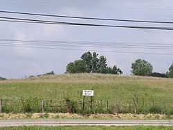
Portsmouth |
|
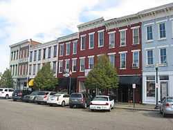
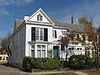
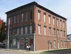
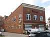
| 2 |
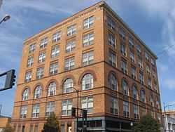
Anderson Brothers Department Store |
|
02001-02-02-0000February 2, 2001
(#01000052) |
301-307 Chillicothe St.
38°43′57″N 82°59′49″W / 38.732500°N 82.996944°W / 38.732500; -82.996944 (Anderson Brothers Department Store) |
Portsmouth |
|
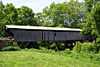
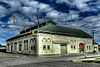
| 3 |
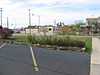
Bennett Schoolhouse Road Covered Bridge |
Upload image |
01978-10-11-0000October 11, 1978
(#78002185) |
Southeast of Minford
38°49′45″N 82°48′26″W / 38.829167°N 82.807222°W / 38.829167; -82.807222 (Bennett Schoolhouse Road Covered Bridge) |
Harrison Township |
|
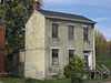
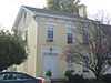
| 4 |
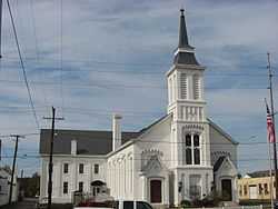
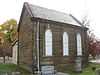
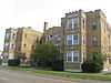
Bigelow United Methodist Church |
|
01987-12-08-0000December 8, 1987
(#87002073) |
415 Washington St.
38°44′02″N 82°59′56″W / 38.733889°N 82.998889°W / 38.733889; -82.998889 (Bigelow United Methodist Church) |
Portsmouth |
|
| 5 |
Boneyfiddle Commercial District |
|
01979-06-06-0000June 6, 1979
(#79001938) |
Roughly bounded by Front, Washington, 3rd, and Scioto Sts.
38°43′54″N 83°00′19″W / 38.731667°N 83.005278°W / 38.731667; -83.005278 (Boneyfiddle Commercial District) |
Portsmouth |
|
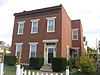
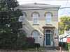
| 6 |
Cunningham-Maier House |
|
01987-12-08-0000December 8, 1987
(#87002074) |
506 6th St.
38°44′05″N 83°00′09″W / 38.734722°N 83.002500°W / 38.734722; -83.002500 (Cunningham-Maier House) |
Portsmouth |
|
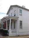
| 7 |
Dole-Darrell House |
|
01987-12-08-0000December 8, 1987
(#87002075) |
322 Market St.
38°43′59″N 83°00′10″W / 38.733139°N 83.002778°W / 38.733139; -83.002778 (Dole-Darrell House) |
Portsmouth |
|
| 8 |
Elden House |
|
01987-12-08-0000December 8, 1987
(#87002076) |
634 4th St.
38°43′59″N 82°59′58″W / 38.733056°N 82.999444°W / 38.733056; -82.999444 (Elden House) |
Portsmouth |
|
| 9 |
Evangelical Church of Christ |
|
01987-12-08-0000December 8, 1987
(#87002077) |
701 5th St.
38°44′03″N 82°59′54″W / 38.734167°N 82.998472°W / 38.734167; -82.998472 (Evangelical Church of Christ) |
Portsmouth |
|
| 10 |
Feurt Mounds and Village Site |
|
01973-06-18-0000June 18, 1973
(#73001531) |
Eastern bank of the Scioto River along the western side of U.S. Route 23, north of Portsmouth[6]
38°48′21″N 82°59′19″W / 38.805833°N 82.988611°W / 38.805833; -82.988611 (Feurt Mounds and Village Site) |
Clay Township |
|
| 11 |
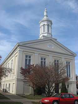
First Presbyterian Church |
|
01973-11-28-0000November 28, 1973
(#73001532) |
221 Court St.
38°43′56″N 83°00′04″W / 38.732222°N 83.001111°W / 38.732222; -83.001111 (First Presbyterian Church) |
Portsmouth |
|
| 12 |
George H. Gharky House |
|
01987-12-08-0000December 8, 1987
(#87002078) |
638 4th St.
38°43′58″N 82°59′56″W / 38.732778°N 82.998889°W / 38.732778; -82.998889 (George H. Gharky House) |
Portsmouth |
|
| 13 |
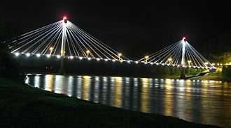
General U.S. Grant Bridge |
|
02001-05-31-0000May 31, 2001
(#01000560) |
Spanning the Ohio River, beginning at the intersection of Chillicothe and 2nd Sts.
38°43′50″N 82°59′49″W / 38.730556°N 82.996944°W / 38.730556; -82.996944 (General U.S. Grant Bridge) |
Portsmouth |
Extends into Greenup County, Kentucky. Demolished in 2001.
|
| 14 |
Greenlawn Cemetery Chapel |
|
01980-01-03-0000January 3, 1980
(#80003216) |
Offnere St.
38°44′38″N 82°59′04″W / 38.743833°N 82.984306°W / 38.743833; -82.984306 (Greenlawn Cemetery Chapel) |
Portsmouth |
|
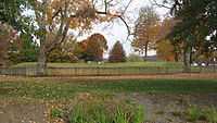
| 15 |
Horseshoe Mound |
|
01974-05-02-0000May 2, 1974
(#74001621) |
Within Mound Park
38°44′35″N 82°58′40″W / 38.743056°N 82.977778°W / 38.743056; -82.977778 (Horseshoe Mound) |
Portsmouth |
|
| 16 |
Hurth Hotel |
|
01983-07-28-0000July 28, 1983
(#83002056) |
222 Chillicothe St.
38°43′56″N 82°59′48″W / 38.732222°N 82.996667°W / 38.732222; -82.996667 (Hurth Hotel) |
Portsmouth |
|
| 17 |
Aaron Kinney House |
|
01973-07-02-0000July 2, 1973
(#73001533) |
Waller St.
38°44′51″N 82°59′19″W / 38.7475°N 82.988611°W / 38.7475; -82.988611 (Aaron Kinney House) |
Portsmouth |
|
| 18 |
Eli Kinney House |
|
01988-03-10-0000March 10, 1988
(#87002079) |
317 Court St.
38°43′59″N 83°00′04″W / 38.733056°N 83.001111°W / 38.733056; -83.001111 (Eli Kinney House) |
Portsmouth |
|
| 19 |
Labold House and Gardens |
|
01987-12-08-0000December 8, 1987
(#87002085) |
633 4th St.
38°44′00″N 82°59′57″W / 38.733333°N 82.999167°W / 38.733333; -82.999167 (Labold House and Gardens) |
Portsmouth |
|
| 20 |
Joseph Marsh House |
|
01987-12-08-0000December 8, 1987
(#87002087) |
701 Market St.
38°44′09″N 83°00′11″W / 38.735833°N 83.003056°W / 38.735833; -83.003056 (Joseph Marsh House) |
Portsmouth |
|
| 21 |
Meyer House |
|
01988-03-10-0000March 10, 1988
(#87002088) |
309 Washington St.
38°43′58″N 82°59′56″W / 38.732778°N 82.998889°W / 38.732778; -82.998889 (Meyer House) |
Portsmouth |
|
| 22 |
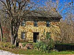
Philip Moore Stone House |
|
01975-10-21-0000October 21, 1975
(#75001531) |
South of West Portsmouth on State Route 239
38°44′36″N 83°02′02″W / 38.743333°N 83.033889°W / 38.743333; -83.033889 (Philip Moore Stone House) |
Washington Township |
|
| 23 |
William Newman House |
|
01987-12-08-0000December 8, 1987
(#87002089) |
716 2nd St.
38°43′53″N 82°59′54″W / 38.731389°N 82.998333°W / 38.731389; -82.998333 (William Newman House) |
Portsmouth |
|
| 24 |
Odd Fellows Hall |
|
01987-12-08-0000December 8, 1987
(#87002090) |
500-506 Court St.
38°44′03″N 83°00′02″W / 38.734167°N 83.000556°W / 38.734167; -83.000556 (Odd Fellows Hall) |
Portsmouth |
|
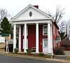
| 25 |
Otway Covered Bridge |
|
01974-05-03-0000May 3, 1974
(#74002280) |
North of State Route 348
38°51′46″N 83°11′24″W / 38.862778°N 83.19°W / 38.862778; -83.19 (Otway Covered Bridge) |
Otway |
|
| 26 |
Portsmouth Fire Department No. 1 |
|
01987-12-08-0000December 8, 1987
(#87002091) |
642 7th St.
38°44′08″N 82°59′56″W / 38.735556°N 82.998889°W / 38.735556; -82.998889 (Portsmouth Fire Department No. 1) |
Portsmouth |
|
| 27 |
Portsmouth Foundry and Machine Works |
|
01987-12-08-0000December 8, 1987
(#87002095) |
401 3rd St.
38°43′57″N 83°00′18″W / 38.7325°N 83.005°W / 38.7325; -83.005 (Portsmouth Foundry and Machine Works) |
Portsmouth |
|
| 28 |
Purdum-Tracy House |
|
01987-12-08-0000December 8, 1987
(#87002097) |
626 4th St.
38°43′59″N 82°59′59″W / 38.733056°N 82.999722°W / 38.733056; -82.999722 (Purdum-Tracy House) |
Portsmouth |
|
| 29 |
Joseph G. Reed Company |
|
01987-12-08-0000December 8, 1987
(#87002099) |
700 2nd St.
38°43′53″N 82°59′56″W / 38.731389°N 82.998889°W / 38.731389; -82.998889 (Joseph G. Reed Company) |
Portsmouth |
|
| 30 |
St. Mary's Roman Catholic Church |
|
01979-08-24-0000August 24, 1979
(#79001940) |
5th and Market Sts.
38°44′04″N 83°00′08″W / 38.734333°N 83.002222°W / 38.734333; -83.002222 (St. Mary's Roman Catholic Church) |
Portsmouth |
|
| 31 |
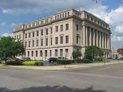
Scioto County Courthouse |
|
01987-12-08-0000December 8, 1987
(#87002101) |
Bounded by 7th, Court, 6th, and Washington Sts.
38°44′07″N 83°00′01″W / 38.735278°N 83.000278°W / 38.735278; -83.000278 (Scioto County Courthouse) |
Portsmouth |
|
| 32 |
Second Presbyterian Church |
|
01996-08-22-0000August 22, 1996
(#96000926) |
801 Waller St.
38°44′11″N 82°59′24″W / 38.736389°N 82.990000°W / 38.736389; -82.990000 (Second Presbyterian Church) |
Portsmouth |
|
| 33 |
Second Street Historic District |
|
01983-11-30-0000November 30, 1983
(#83004336) |
2nd St.
38°43′52″N 82°59′25″W / 38.731111°N 82.990278°W / 38.731111; -82.990278 (Second Street Historic District) |
Portsmouth |
|
| 34 |
Sixth Street Historic District |
|
01988-03-10-0000March 10, 1988
(#87002103) |
533, 534, 537, 538, 541, 542, 543, 547, and 548 6th St., west of Court St.
38°44′05″N 83°00′04″W / 38.734722°N 83.001111°W / 38.734722; -83.001111 (Sixth Street Historic District) |
Portsmouth |
|
| 35 |
Steindam House |
|
01987-12-08-0000December 8, 1987
(#87002104) |
725 Court St.
38°44′12″N 83°00′03″W / 38.736528°N 83.000833°W / 38.736528; -83.000833 (Steindam House) |
Portsmouth |
|
| 36 |
Streich Apartments |
|
01987-12-08-0000December 8, 1987
(#87002105) |
716-722 Washington St.
38°44′10″N 82°59′54″W / 38.736111°N 82.998333°W / 38.736111; -82.998333 (Streich Apartments) |
Portsmouth |
|
| 37 |
Tremper Mound and Works |
|
01972-12-08-0000December 8, 1972
(#72001041) |
West of State Routes 73 and 104 north of West Portsmouth[7]
38°48′06″N 83°00′36″W / 38.8017°N 83.01°W / 38.8017; -83.01 (Tremper Mound and Works) |
Rush Township |
|
| 38 |
Tripp-Bauer Building |
Upload image |
01988-06-09-0000June 9, 1988
(#88000719) |
51-53 N. Jackson St.
38°49′00″N 82°43′35″W / 38.816667°N 82.726389°W / 38.816667; -82.726389 (Tripp-Bauer Building) |
South Webster |
|
| 39 |
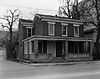
Zottman House |
|
01996-08-08-0000August 8, 1996
(#96000882) |
11 Offnere St.
38°43′46″N 82°59′09″W / 38.729583°N 82.985833°W / 38.729583; -82.985833 (Zottman House) |
Portsmouth |
|