| [3] |
Name on the Register[4] |
Image |
Date listed[5] |
Location |
City or town |
Description |
|---|
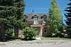
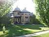
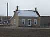
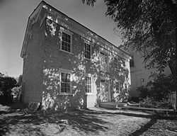
| 1 |
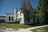
Claus P. Andersen House |
Upload image |
01983-02-01-0000February 1, 1983
(#83003183) |
200 E. 200 South
39°21′22″N 111°34′55″W / 39.356111°N 111.582083°W / 39.356111; -111.582083 (Claus P. Andersen House) |
Ephraim |
|
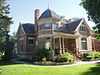
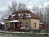
| 2 |
Lars S. Andersen House |
Upload image |
01983-02-01-0000February 1, 1983
(#83003184) |
213 N. 200 East
39°21′49″N 111°34′53″W / 39.363611°N 111.581389°W / 39.363611; -111.581389 (Lars S. Andersen House) |
Ephraim |
|
| 3 |
James Anderson House |
|
01980-10-03-0000October 3, 1980
(#80003945) |
15 S. 200 East
39°37′40″N 111°26′03″W / 39.627778°N 111.434167°W / 39.627778; -111.434167 (James Anderson House) |
Fairview |
|
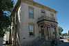
| 4 |
Lewis and Clara Anderson House |
Upload image |
01998-01-12-0000January 12, 1998
(#97001629) |
542 S. Main St.
39°15′27″N 111°38′12″W / 39.2575°N 111.636667°W / 39.2575; -111.636667 (Lewis and Clara Anderson House) |
Manti |
|
| 5 |
Niels Ole Anderson House |
Upload image |
01978-10-05-0000October 5, 1978
(#78002687) |
306 S. 100 East
39°21′16″N 111°35′02″W / 39.354444°N 111.583889°W / 39.354444; -111.583889 (Niels Ole Anderson House) |
Ephraim |
|
| 6 |
Ole Arilsen House |
Upload image |
01980-10-03-0000October 3, 1980
(#80003953) |
89 N. 300 East
39°32′51″N 111°26′57″W / 39.5475°N 111.449167°W / 39.5475; -111.449167 (Ole Arilsen House) |
Mount Pleasant |
|
| 7 |
Andrew Barentsen House |
Upload image |
01983-02-01-0000February 1, 1983
(#83003185) |
195 W. 200 South
39°37′28″N 111°38′22″W / 39.624444°N 111.639444°W / 39.624444; -111.639444 (Andrew Barentsen House) |
Fountain Green |
|
| 8 |
Anthony W. Bessey House |
Upload image |
01980-10-22-0000October 22, 1980
(#80003947) |
415 N. 300 West
39°16′18″N 111°38′33″W / 39.271667°N 111.6425°W / 39.271667; -111.6425 (Anthony W. Bessey House) |
Manti |
|
| 9 |
Billings-Hougaard House |
Upload image |
01980-10-14-0000October 14, 1980
(#80003948) |
75 E. 300 North
39°16′13″N 111°38′09″W / 39.270278°N 111.635833°W / 39.270278; -111.635833 (Billings-Hougaard House) |
Manti |
|
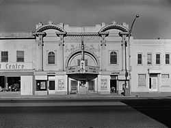
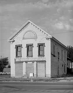
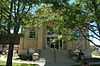
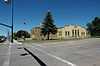
| 10 |
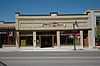
Casino Theatre |
|
01989-09-22-0000September 22, 1989
(#89001416) |
78 S. Main St.
39°09′15″N 111°49′04″W / 39.154167°N 111.817778°W / 39.154167; -111.817778 (Casino Theatre) |
Gunnison |
|
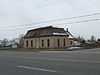
| 11 |
Centerfield School and Meetinghouse |
|
02000-09-12-0000September 12, 2000
(#00001068) |
140 S. Main St.
39°07′25″N 111°49′08″W / 39.123611°N 111.818889°W / 39.123611; -111.818889 (Centerfield School and Meetinghouse) |
Centerfield |
|
| 12 |
Cox-Shoemaker-Parry House |
Upload image |
01982-08-04-0000August 4, 1982
(#82004157) |
50 N. 100 West
39°15′59″N 111°38′16″W / 39.266389°N 111.637778°W / 39.266389; -111.637778 (Cox-Shoemaker-Parry House) |
Manti |
|
| 13 |
Charles Crawforth Farmstead |
Upload image |
01980-02-19-0000February 19, 1980
(#80003956) |
Southwest of Spring City on Pigeon Hollow Rd.
39°27′16″N 111°30′43″W / 39.454444°N 111.511944°W / 39.454444; -111.511944 (Charles Crawforth Farmstead) |
Spring City |
|
| 14 |
John Dorius, Jr. House |
|
01985-05-09-0000May 9, 1985
(#85000964) |
46 W. 100 North
39°21′43″N 111°35′14″W / 39.361944°N 111.587222°W / 39.361944; -111.587222 (John Dorius, Jr. House) |
Ephraim |
|
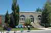
| 15 |
Ephraim Carnegie Library |
|
01984-10-25-0000October 25, 1984
(#84000149) |
30 S. Main St.
39°22′05″N 111°35′12″W / 39.368056°N 111.586667°W / 39.368056; -111.586667 (Ephraim Carnegie Library) |
Ephraim |
|
| 16 |
Ephraim United Order Cooperative Building |
|
01973-03-20-0000March 20, 1973
(#73001862) |
Main and 1st North Sts.
39°21′41″N 111°35′09″W / 39.361389°N 111.585833°W / 39.361389; -111.585833 (Ephraim United Order Cooperative Building) |
Ephraim |
|
| 17 |
Fairview Amusement Hall |
|
02002-05-10-0000May 10, 2002
(#02000507) |
75 S. State St.
39°37′38″N 111°26′18″W / 39.627222°N 111.438333°W / 39.627222; -111.438333 (Fairview Amusement Hall) |
Fairview |
|
| 18 |
Fairview City Hall |
|
01986-04-09-0000April 9, 1986
(#86000745) |
85 S. State St.
39°37′36″N 111°26′18″W / 39.626667°N 111.438333°W / 39.626667; -111.438333 (Fairview City Hall) |
Fairview |
|
| 19 |
Fairview Tithing Office/Bishop's Storehouse |
|
01985-01-25-0000January 25, 1985
(#85000281) |
60 W. 100 South
39°37′36″N 111°26′23″W / 39.626667°N 111.439722°W / 39.626667; -111.439722 (Fairview Tithing Office/Bishop's Storehouse) |
Fairview |
|
| 20 |
Jabez Faux House and Barn |
Upload image |
01976-11-07-0000November 7, 1976
(#76001835) |
Approximately 74 N. State Route 132
39°31′35″N 111°35′24″W / 39.526389°N 111.59°W / 39.526389; -111.59 (Jabez Faux House and Barn) |
Moroni |
|
| 21 |
Fountain Green Hydroelectric Plant Historic District |
Upload image |
01989-04-20-0000April 20, 1989
(#89000277) |
Northwest of Fountain Green
39°38′11″N 111°40′19″W / 39.636389°N 111.671944°W / 39.636389; -111.671944 (Fountain Green Hydroelectric Plant Historic District) |
Fountain Green |
|
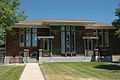
| 22 |
Great Basin Research Station Historic District |
Upload image |
01996-06-28-0000June 28, 1996
(#96000678) |
State Route 29, approximately 8 miles (13 km) east of Ephraim in the Manti-La Sal National Forest
Coordinates missing |
Ephraim |
|
| 23 |
Greaves-Deakin House |
|
01980-10-03-0000October 3, 1980
(#80003942) |
118 S. Main St.
39°21′27″N 111°35′13″W / 39.3575°N 111.586944°W / 39.3575; -111.586944 (Greaves-Deakin House) |
Ephraim |
|
| 24 |
Hans A. Hansen House |
|
01980-10-22-0000October 22, 1980
(#80003943) |
75 W. 100 North
39°21′41″N 111°35′15″W / 39.361389°N 111.5875°W / 39.361389; -111.5875 (Hans A. Hansen House) |
Ephraim |
|
| 25 |
Peter Hansen House |
Upload image |
01983-02-01-0000February 1, 1983
(#83003187) |
247 S. 200 East
39°15′42″N 111°37′56″W / 39.261667°N 111.632222°W / 39.261667; -111.632222 (Peter Hansen House) |
Manti |
|
| 26 |
Niels P. Hjort House |
|
01980-10-03-0000October 3, 1980
(#80003946) |
26 S. State St.
39°37′40″N 111°26′20″W / 39.627778°N 111.438889°W / 39.627778; -111.438889 (Niels P. Hjort House) |
Fairview |
|
| 27 |
Frederick C. Jensen House |
Upload image |
01982-04-19-0000April 19, 1982
(#82004158) |
215 S. 100 West
39°32′37″N 111°27′22″W / 39.543611°N 111.456111°W / 39.543611; -111.456111 (Frederick C. Jensen House) |
Mount Pleasant |
|
| 28 |
Hans C. Jensen House |
Upload image |
01983-02-01-0000February 1, 1983
(#83003188) |
263 E. 100 South
39°21′31″N 111°34′46″W / 39.358611°N 111.579444°W / 39.358611; -111.579444 (Hans C. Jensen House) |
Ephraim |
|
| 29 |
Rasmus Jensen House |
Upload image |
01983-02-01-0000February 1, 1983
(#83003189) |
97 E. 100 South
39°21′29″N 111°35′04″W / 39.358194°N 111.584583°W / 39.358194; -111.584583 (Rasmus Jensen House) |
Ephraim |
|
| 30 |
Robert Johnson House |
Upload image |
01980-10-14-0000October 14, 1980
(#80003949) |
103 E. 300 North
39°16′13″N 111°38′02″W / 39.270278°N 111.633889°W / 39.270278; -111.633889 (Robert Johnson House) |
Manti |
|
| 31 |
Johnson-Nielson House |
|
01982-07-26-0000July 26, 1982
(#82004156) |
351 N. Main St.
39°22′00″N 111°35′12″W / 39.366667°N 111.586667°W / 39.366667; -111.586667 (Johnson-Nielson House) |
Ephraim |
|
| 32 |
Francis Marion Jolley House |
Upload image |
01980-10-14-0000October 14, 1980
(#80003950) |
201 S. 200 East
39°15′45″N 111°37′56″W / 39.2625°N 111.632222°W / 39.2625; -111.632222 (Francis Marion Jolley House) |
Manti |
|
| 33 |
Oluf Larsen House |
Upload image |
01983-02-01-0000February 1, 1983
(#83003190) |
75 S. 100 West
39°21′31″N 111°35′18″W / 39.358611°N 111.588333°W / 39.358611; -111.588333 (Oluf Larsen House) |
Ephraim |
|
| 34 |
Larsen-Noyes House |
|
01978-12-01-0000December 1, 1978
(#78002688) |
96 E. Center St.
39°21′34″N 111°35′01″W / 39.359444°N 111.583611°W / 39.359444; -111.583611 (Larsen-Noyes House) |
Ephraim |
|
| 35 |
John T. Lewellyn House |
Upload image |
01980-10-03-0000October 3, 1980
(#80003958) |
15 N. State St.
39°29′09″N 111°38′05″W / 39.485833°N 111.634722°W / 39.485833; -111.634722 (John T. Lewellyn House) |
Wales |
|
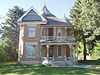
| 36 |
David and Evinda Madsen House |
Upload image |
02014-07-03-0000July 3, 2014
(#14000383) |
60 N. 100 W.
39°21′39″N 111°35′23″W / 39.360972°N 111.589861°W / 39.360972; -111.589861 (David and Evinda Madsen House) |
Ephraim |
|
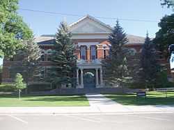
| 37 |
Manti Carnegie Library |
|
01984-10-25-0000October 25, 1984
(#84000150) |
2 S. Main St.
39°15′55″N 111°37′59″W / 39.265278°N 111.633056°W / 39.265278; -111.633056 (Manti Carnegie Library) |
Manti |
|
| 38 |
Manti City Hall |
|
01985-06-27-0000June 27, 1985
(#85001397) |
191 N. Main St.
39°16′08″N 111°38′32″W / 39.268889°N 111.642222°W / 39.268889; -111.642222 (Manti City Hall) |
Manti |
|
| 39 |
Manti Motor Company Building |
|
02008-05-07-0000May 7, 2008
(#08000384) |
87 N. Main St.
39°16′00″N 111°38′13″W / 39.26671°N 111.63703°W / 39.26671; -111.63703 (Manti Motor Company Building) |
Manti |
|
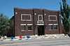
| 40 |
Manti National Guard Armory |
|
01986-04-09-0000April 9, 1986
(#86000744) |
50 E. 100 North
39°16′00″N 111°38′08″W / 39.266667°N 111.635556°W / 39.266667; -111.635556 (Manti National Guard Armory) |
Manti |
|
| 41 |
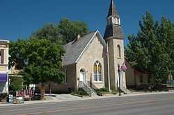
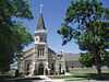
Manti Presbyterian Church |
|
01980-03-27-0000March 27, 1980
(#80003951) |
185 S. Main St.
39°15′42″N 111°38′08″W / 39.261667°N 111.635556°W / 39.261667; -111.635556 (Manti Presbyterian Church) |
Manti |
|
| 42 |
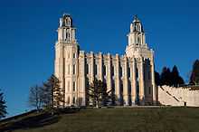
Manti Temple |
|
01971-08-12-0000August 12, 1971
(#71000854) |
Northern edge of Manti, on U.S. Route 89
39°16′23″N 111°37′59″W / 39.273056°N 111.633056°W / 39.273056; -111.633056 (Manti Temple) |
Manti |
|
| 43 |
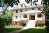
James and Caroline M. Metcalf House |
|
01998-07-23-0000July 23, 1998
(#98000905) |
290 E. 500 South
39°08′43″N 111°48′32″W / 39.145278°N 111.808889°W / 39.145278; -111.808889 (James and Caroline M. Metcalf House) |
Gunnison |
|
| 44 |
Moroni High School Mechanical Arts Building |
Upload image |
01985-04-01-0000April 1, 1985
(#85000812) |
350 N. Center St.
39°31′51″N 111°34′58″W / 39.530833°N 111.582778°W / 39.530833; -111.582778 (Moroni High School Mechanical Arts Building) |
Moroni |
|
| 45 |
Moroni Opera House |
Upload image |
01996-05-23-0000May 23, 1996
(#96000590) |
325 W. Main St.
39°31′30″N 111°35′23″W / 39.525°N 111.589722°W / 39.525; -111.589722 (Moroni Opera House) |
Moroni |
|
| 46 |
Mortensen-Nelson House |
Upload image |
02003-07-10-0000July 10, 2003
(#03000632) |
291 E. 100 South
39°31′26″N 111°34′40″W / 39.523889°N 111.577778°W / 39.523889; -111.577778 (Mortensen-Nelson House) |
Moroni |
|
| 47 |
Mount Pleasant Carnegie Library |
|
01984-10-25-0000October 25, 1984
(#84000152) |
24 E. Main St.
39°32′48″N 111°27′14″W / 39.546667°N 111.453889°W / 39.546667; -111.453889 (Mount Pleasant Carnegie Library) |
Mount Pleasant |
|
| 48 |
Mount Pleasant Commercial Historic District |
|
01979-10-26-0000October 26, 1979
(#79002508) |
U.S. Route 89 and State Route 116
39°32′46″N 111°27′22″W / 39.546111°N 111.456111°W / 39.546111; -111.456111 (Mount Pleasant Commercial Historic District) |
Mount Pleasant |
|
| 49 |
Mount Pleasant High School Mechanical Arts Building |
Upload image |
01985-04-01-0000April 1, 1985
(#85000813) |
150 N. State St.
39°32′58″N 111°27′13″W / 39.549444°N 111.453611°W / 39.549444; -111.453611 (Mount Pleasant High School Mechanical Arts Building) |
Mount Pleasant |
|
| 50 |
Mount Pleasant National Guard Armory |
|
01986-04-09-0000April 9, 1986
(#86000740) |
10 N. State St.
39°32′50″N 111°27′14″W / 39.547222°N 111.453889°W / 39.547222; -111.453889 (Mount Pleasant National Guard Armory) |
Mount Pleasant |
|
| 51 |
Jens Nielsen House |
Upload image |
01983-02-01-0000February 1, 1983
(#83003191) |
192 W. 200 South
39°21′24″N 111°35′27″W / 39.356667°N 111.590833°W / 39.356667; -111.590833 (Jens Nielsen House) |
Ephraim |
|
| 52 |
John R. Nielson Cabin |
Upload image |
02004-06-08-0000June 8, 2004
(#03000772) |
Manti Canyon
39°15′59″N 111°30′02″W / 39.266389°N 111.500556°W / 39.266389; -111.500556 (John R. Nielson Cabin) |
Manti |
|
| 53 |
N.S. Nielson House |
Upload image |
01982-07-26-0000July 26, 1982
(#82004160) |
179 W. Main St.
39°32′47″N 111°27′29″W / 39.546389°N 111.458056°W / 39.546389; -111.458056 (N.S. Nielson House) |
Mount Pleasant |
|
| 54 |
Oberg-Metcalf House |
|
01997-11-24-0000November 24, 1997
(#97001464) |
12 N. 100 East
39°09′19″N 111°49′05″W / 39.155278°N 111.818056°W / 39.155278; -111.818056 (Oberg-Metcalf House) |
Gunnison |
|
| 55 |
Hans Peter Olsen House |
Upload image |
01976-04-22-0000April 22, 1976
(#76001834) |
215 S. State St.
39°37′36″N 111°38′00″W / 39.626667°N 111.633333°W / 39.626667; -111.633333 (Hans Peter Olsen House) |
Fountain Green |
|
| 56 |
Hans Ottesen House |
Upload image |
01987-08-06-0000August 6, 1987
(#87001177) |
202 S. 200 West
39°15′45″N 111°38′25″W / 39.2625°N 111.640278°W / 39.2625; -111.640278 (Hans Ottesen House) |
Manti |
|
| 57 |
John Patten House |
Upload image |
01977-08-22-0000August 22, 1977
(#77001315) |
95 W. 300 North
39°16′18″N 111°38′17″W / 39.271667°N 111.638056°W / 39.271667; -111.638056 (John Patten House) |
Manti |
|
| 58 |
Canute Peterson House |
|
01978-07-17-0000July 17, 1978
(#78002689) |
10 N. Main St.
39°21′36″N 111°35′09″W / 39.36°N 111.585833°W / 39.36; -111.585833 (Canute Peterson House) |
Ephraim |
|
| 59 |
Poulsen-Hall House |
Upload image |
02011-04-27-0000April 27, 2011
(#11000235) |
90 S. 100 East
39°15′51″N 111°38′07″W / 39.264167°N 111.635278°W / 39.264167; -111.635278 (Poulsen-Hall House) |
Manti |
|
| 60 |
Morten Rasmussen House |
Upload image |
01977-08-18-0000August 18, 1977
(#77001317) |
417 W. Main St.
39°32′47″N 111°27′46″W / 39.546389°N 111.462778°W / 39.546389; -111.462778 (Morten Rasmussen House) |
Mount Pleasant |
|
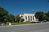
| 61 |
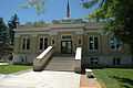
Sanpete County Courthouse |
|
01985-04-01-0000April 1, 1985
(#85000811) |
160 N. Main St.
39°16′05″N 111°38′09″W / 39.268056°N 111.635833°W / 39.268056; -111.635833 (Sanpete County Courthouse) |
Manti |
|
| 62 |
William Stuart Seeley House |
Upload image |
01992-07-16-0000July 16, 1992
(#92000894) |
150 S. State St.
39°32′41″N 111°27′18″W / 39.544722°N 111.455°W / 39.544722; -111.455 (William Stuart Seeley House) |
Mount Pleasant |
|
| 63 |
John H. Seely House |
Upload image |
01982-03-09-0000March 9, 1982
(#82004159) |
91 S. 5th West
39°32′44″N 111°27′50″W / 39.545556°N 111.463889°W / 39.545556; -111.463889 (John H. Seely House) |
Mount Pleasant |
|
| 64 |
Ezra and Abigail Shomaker House |
Upload image |
02014-10-15-0000October 15, 2014
(#14000864) |
194 W. 400 North
39°16′17″N 111°38′26″W / 39.2713°N 111.6405°W / 39.2713; -111.6405 (Ezra and Abigail Shomaker House) |
Manti |
|
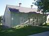
| 65 |
Snow Academy Building |
|
01987-11-20-0000November 20, 1987
(#87002062) |
150 College Ave.
39°21′40″N 111°34′56″W / 39.361111°N 111.582222°W / 39.361111; -111.582222 (Snow Academy Building) |
Ephraim |
|
| 66 |
Dykes Sorensen House |
Upload image |
01982-10-20-0000October 20, 1982
(#82001756) |
302 S. 200 East
39°21′15″N 111°34′53″W / 39.354167°N 111.581389°W / 39.354167; -111.581389 (Dykes Sorensen House) |
Ephraim |
|
| 67 |
Fredrick Christian Sorensen House |
|
01980-10-14-0000October 14, 1980
(#80003944) |
62 E. Center St.
39°21′35″N 111°35′06″W / 39.359722°N 111.585°W / 39.359722; -111.585 (Fredrick Christian Sorensen House) |
Ephraim |
|
| 68 |
Spring City Historic District |
|
01980-10-22-0000October 22, 1980
(#80003957) |
State Route 117
39°28′37″N 111°29′47″W / 39.476944°N 111.496389°W / 39.476944; -111.496389 (Spring City Historic District) |
Spring City |
|
| 69 |
Spring City School |
|
01978-11-14-0000November 14, 1978
(#78002691) |
45 S. 100 East
39°28′40″N 111°29′35″W / 39.477778°N 111.493056°W / 39.477778; -111.493056 (Spring City School) |
Spring City |
|
| 70 |
Alma Staker House |
Upload image |
01979-07-09-0000July 9, 1979
(#79002509) |
81 E. 300 South
39°32′33″N 111°27′11″W / 39.5425°N 111.453056°W / 39.5425; -111.453056 (Alma Staker House) |
Mount Pleasant |
|
| 71 |
James B. Staker House |
Upload image |
01980-10-03-0000October 3, 1980
(#80003954) |
209 N. State St.
39°33′00″N 111°27′19″W / 39.55°N 111.455278°W / 39.55; -111.455278 (James B. Staker House) |
Mount Pleasant |
|
| 72 |
Tuttle-Folsom House |
Upload image |
01977-07-21-0000July 21, 1977
(#77001316) |
195 W. 300 North
39°16′11″N 111°38′23″W / 39.269722°N 111.639722°W / 39.269722; -111.639722 (Tuttle-Folsom House) |
Manti |
|
| 73 |
Wales Co-operative Mercantile Institution |
Upload image |
02000-09-29-0000September 29, 2000
(#00001176) |
150 N. State St.
39°29′16″N 111°38′03″W / 39.487778°N 111.634167°W / 39.487778; -111.634167 (Wales Co-operative Mercantile Institution) |
Wales |
|
| 74 |
Wasatch Academy |
|
01978-10-02-0000October 2, 1978
(#78002690) |
200 S. 100 West
39°32′39″N 111°27′26″W / 39.544167°N 111.457222°W / 39.544167; -111.457222 (Wasatch Academy) |
Mount Pleasant |
|
| 75 |
Watkins-Tholman-Larsen Farmstead |
Upload image |
01996-12-27-0000December 27, 1996
(#96001531) |
422 E. 400 South St.
39°32′27″N 111°26′49″W / 39.540833°N 111.446944°W / 39.540833; -111.446944 (Watkins-Tholman-Larsen Farmstead) |
Mount Pleasant |
|
| 76 |
Cyrus Wheelock House |
Upload image |
01980-10-03-0000October 3, 1980
(#80003955) |
200 E. 100 North
39°32′54″N 111°27′02″W / 39.548333°N 111.450556°W / 39.548333; -111.450556 (Cyrus Wheelock House) |
Mount Pleasant |
|