National Register of Historic Places listings in Sandusky County, Ohio
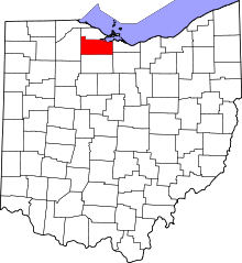
Location of Sandusky County in Ohio
This is a list of the National Register of Historic Places listings in Sandusky County, Ohio.
This is intended to be a complete list of the properties and districts on the National Register of Historic Places in Sandusky County, Ohio, United States. The locations of National Register properties and districts for which the latitude and longitude coordinates are included below, may be seen in a Google map.[1]
There are 12 properties and districts listed on the National Register in the county, including 1 National Historic Landmark. Another property was once listed but has been removed.
- This National Park Service list is complete through NPS recent listings posted May 1, 2015.[2]
Current listings
| [3] |
Name on the Register[4] |
Image |
Date listed[5] |
Location |
City or town |
Description |
|---|
| 1 |
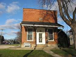
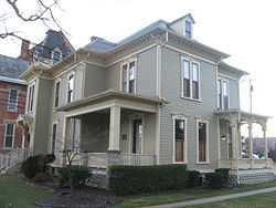
Joseph and Rachel Bartlett House |
|
01990-03-21-0000March 21, 1990
(#90000388) |
212 S. Park Ave.
41°20′42″N 83°07′03″W / 41.345000°N 83.117500°W / 41.345000; -83.117500 (Joseph and Rachel Bartlett House) |
Fremont |
|
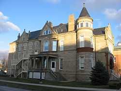
| 2 |
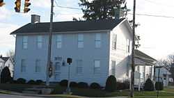
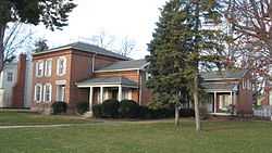
Ralph P. Buckland House |
|
01974-12-17-0000December 17, 1974
(#74001620) |
300 S. Park Ave.
41°20′38″N 83°07′04″W / 41.344027°N 83.117778°W / 41.344027; -83.117778 (Ralph P. Buckland House) |
Fremont |
|
| 3 |
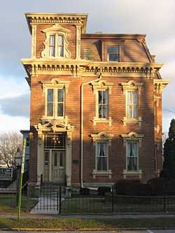
Georg Cronenwett House |
|
01978-12-01-0000December 1, 1978
(#78002184) |
606 W. Main St.
41°27′11″N 83°22′07″W / 41.453055°N 83.368611°W / 41.453055; -83.368611 (Georg Cronenwett House) |
Woodville |
|
| 4 |
Frederick Fabing House |
|
01983-05-26-0000May 26, 1983
(#83002054) |
201 S. Park Ave.
41°20′43″N 83°07′01″W / 41.345277°N 83.116944°W / 41.345277; -83.116944 (Frederick Fabing House) |
Fremont |
|
| 5 |
Rutherford B. Hayes House |
|
01966-10-15-0000October 15, 1966
(#66000624) |
Hayes and Buckland Aves.
41°20′27″N 83°07′50″W / 41.340833°N 83.130556°W / 41.340833; -83.130556 (Rutherford B. Hayes House) |
Fremont |
|
| 6 |
Christopher C. Layman Law Office |
|
01986-05-15-0000May 15, 1986
(#86001062) |
212 W. 1st St.
41°27′08″N 83°21′52″W / 41.452333°N 83.364444°W / 41.452333; -83.364444 (Christopher C. Layman Law Office) |
Woodville |
|
| 7 |
Maj. Gen. James B. McPherson House |
|
01974-10-18-0000October 18, 1974
(#74001619) |
300 E. McPherson Highway
41°18′31″N 82°58′17″W / 41.308611°N 82.971389°W / 41.308611; -82.971389 (Maj. Gen. James B. McPherson House) |
Clyde |
|
| 8 |
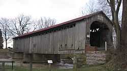
Mull Covered Bridge |
|
01974-10-15-0000October 15, 1974
(#74001618) |
East of Burgoon between State Routes 12 and 53
41°15′39″N 83°11′04″W / 41.260833°N 83.184444°W / 41.260833; -83.184444 (Mull Covered Bridge) |
Ballville Township |
|
| 9 |
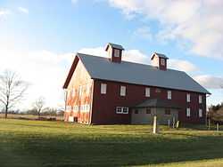
Overmyer-Waggoner-Roush Farm |
|
01983-09-08-0000September 8, 1983
(#83002055) |
654 S. Main St.
41°24′39″N 83°13′18″W / 41.410833°N 83.221667°W / 41.410833; -83.221667 (Overmyer-Waggoner-Roush Farm) |
Lindsey |
|
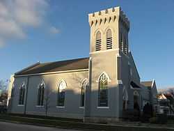
| 10 |
St. Paul's Episcopal Church |
|
01977-06-09-0000June 9, 1977
(#77001085) |
200 N. Park Ave.
41°20′51″N 83°07′03″W / 41.347500°N 83.117500°W / 41.347500; -83.117500 (St. Paul's Episcopal Church) |
Fremont |
|
| 11 |
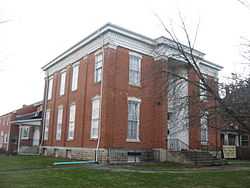
Sandusky County Jail and Sheriff's House |
|
01997-02-27-0000February 27, 1997
(#97000198) |
622 Croghan St.
41°20′49″N 83°07′06″W / 41.346944°N 83.118333°W / 41.346944; -83.118333 (Sandusky County Jail and Sheriff's House) |
Fremont |
|
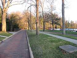
| 12 |
Soldiers Memorial Parkway and McKinley Memorial Parkway |
|
01991-01-25-0000January 25, 1991
(#90002212) |
Soldiers Memorial Parkway and McKinley Memorial Parkway
41°20′24″N 83°07′59″W / 41.34°N 83.133056°W / 41.34; -83.133056 (Soldiers Memorial Parkway and McKinley Memorial Parkway) |
Fremont |
|
Former listing
| [3] |
Name on the Register |
Image |
Date listed | Date removed |
Location |
City or town |
Summary |
|---|
| 1 |
Fremont City Hall |
Upload image |
01978-08-30-0000August 30, 1978
(#78002183) | 01980-02-20-0000February 20, 1980 |
401 Croghan St.
|
Fremont |
|
See also
References
- ↑ The latitude and longitude information provided in this table was derived originally from the National Register Information System, which has been found to be fairly accurate for about 99% of listings. For about 1% of NRIS original coordinates, experience has shown that one or both coordinates are typos or otherwise extremely far off; some corrections may have been made. A more subtle problem causes many locations to be off by up to 150 yards, depending on location in the country: most NRIS coordinates were derived from tracing out latitude and longitudes off of USGS topographical quadrant maps created under the North American Datum of 1927, which differs from the current, highly accurate WGS84 GPS system used by most on-line maps. Chicago is about right, but NRIS longitudes in Washington are higher by about 4.5 seconds, and are lower by about 2.0 seconds in Maine. Latitudes differ by about 1.0 second in Florida. Some locations in this table may have been corrected to current GPS standards.
- ↑ "National Register of Historic Places: Weekly List Actions". National Park Service, United States Department of the Interior. Retrieved on May 1, 2015.
- ↑ 3.0 3.1 Numbers represent an ordering by significant words. Various colorings, defined here, differentiate National Historic Landmarks and historic districts from other NRHP buildings, structures, sites or objects.
- ↑ "National Register Information System". National Register of Historic Places. National Park Service. 2008-04-24.
- ↑ The eight-digit number below each date is the number assigned to each location in the National Register Information System database, which can be viewed by clicking the number.
|
|---|
| | Lists by county | | |
|---|
| | Lists by city | |
|---|
| | Other lists | |
|---|
| |
|
.jpg)