National Register of Historic Places listings in Sagadahoc County, Maine
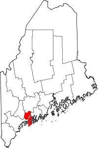
Location of Sagadahoc County in Maine
This is a list of the National Register of Historic Places listings in Sagadahoc County, Maine.
This is intended to be a complete list of the properties and districts on the National Register of Historic Places in Sagadahoc County, Maine, United States. Latitude and longitude coordinates are provided for many National Register properties and districts; these locations may be seen together in a Google map.[1]
There are 57 properties and districts listed on the National Register in the county.
- This National Park Service list is complete through NPS recent listings posted May 1, 2015.[2]
| Androscoggin - Aroostook - Cumberland - Franklin - Hancock - Kennebec - Knox - Lincoln - Oxford - Penobscot - Piscataquis - Sagadahoc - Somerset - Waldo - Washington - York |
Current listings
| [3] | Name on the Register[4] | Image | Date listed[5] | Location | City or town | Description |
|---|---|---|---|---|---|---|
| 1 | Arnold Trail to Quebec |  |
(#69000018) |
Along the Kennebec River, through Wayman and Flagstaff Lakes along the Dead River and Chain of Ponds to Quebec Canada 43°45′08″N 69°46′45″W / 43.7522°N 69.7791°W |
Popham Beach | Extends through Franklin, Kennebec, Sagadahoc, and Somerset counties |
| 2 | Bath Historic District |  |
(#73000261) |
Roughly bounded by High, Beacon, and Court Sts., U.S. Route 1, and the Kennebec River 43°55′07″N 69°49′00″W / 43.918611°N 69.816667°W |
Bath | |
| 3 | Butterfield-Sampson House |  |
(#96001190) |
18 River Rd. 44°00′28″N 69°53′51″W / 44.007778°N 69.8975°W |
Bowdoinham | |
| 4 | Robert P. Carr House | Upload image | (#90001904) |
Main St. 44°00′36″N 69°53′53″W / 44.01°N 69.898056°W |
Bowdoinham | |
| 5 | Cathance Water Tower | Upload image | (#00001637) |
Cathance Rd. at its junction with Beechwood Dr. 43°57′06″N 69°55′50″W / 43.951667°N 69.930556°W |
Topsham | |
| 6 | Clarke and Lake Company Archeological Site | Upload image | (#78000329) |
Address Restricted |
Arrowsic | Site of a major colonial settlement; destroyed during King Philip's War and abandoned. Listed as being in the Bath vicinity. |
| 7 | Cold Spring Farm | Upload image | (#85000274) |
Off Fiddler's Reach Rd. 43°51′12″N 69°48′00″W / 43.853333°N 69.8°W |
Phippsburg | |
| 8 | Viola Coombs House | Upload image | (#91001816) |
Main St. 44°00′36″N 69°53′52″W / 44.01°N 69.897778°W |
Bowdoinham | |
| 9 | Cornish House | Upload image | (#80000250) |
Main St. 44°00′34″N 69°54′08″W / 44.009444°N 69.902222°W |
Bowdoinham | |
| 10 | W.D. Crooker House | 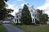 |
(#79000165) |
71 South St. 43°54′28″N 69°49′08″W / 43.907778°N 69.818889°W |
Bath | |
| 11 | Days Ferry Historic District | Upload image | (#75000109) |
North of Bath along State Route 128 43°56′47″N 69°48′24″W / 43.946389°N 69.806667°W |
Woolwich | Listed as being in Bath vicinity. |
| 12 | William T. Donnell House | 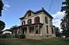 |
(#89000840) |
279 Washington St. 43°53′42″N 69°49′03″W / 43.895°N 69.8175°W |
Bath | Owned by the Maine Maritime Museum. |
| 13 | Doubling Point Light Station | 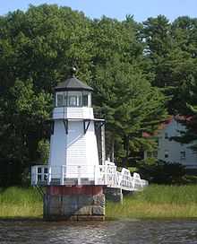 |
(#87002271) |
Western side of Arrowsic Island 43°52′57″N 69°48′27″W / 43.8825°N 69.8075°W |
Arrowsic | Listed as being in Bath vicinity. |
| 14 | Fiddler's Reach Fog Signal | 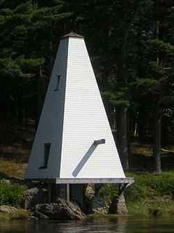 |
(#09000594) |
Northern shore of the Kennebec River, east of the Doubling Point Light Station 43°52′54″N 69°47′57″W / 43.8816°N 69.7993°W |
Arrowsic | |
| 15 | First Baptist Church of Bowdoin and Coombs Cemetery | Upload image | (#97000604) |
Off the western side of U.S. Route 201, 0.65 miles north of its junction with State Route 125 44°02′22″N 69°56′44″W / 44.039444°N 69.945556°W |
Bowdoin Center | |
| 16 | Fort Baldwin Historic Site | 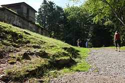 |
(#79000166) |
Sabino Hill 43°45′01″N 69°47′23″W / 43.750278°N 69.789722°W |
Phippsburg | |
| 17 | Fort Popham Memorial | |
(#69000012) |
North of Popham on Hunnewell Point 43°45′19″N 69°47′04″W / 43.755278°N 69.784444°W |
Popham Beach | |
| 18 | Grey Havens Inn | Upload image | (#85000614) |
Reid Park Rd. 43°48′39″N 69°43′16″W / 43.810833°N 69.721111°W |
Georgetown | |
| 19 | Harward Family House | Upload image | (#96001038) |
Western side of Pork Point Rd., 0.4 miles south of its junction with State Route 24 44°01′48″N 69°49′35″W / 44.03°N 69.826389°W |
Richmond | |
| 20 | Lt. Richard Hathorn House | Upload image | (#80000251) |
State Route 127 43°57′57″N 69°46′58″W / 43.965833°N 69.782778°W |
Woolwich | |
| 21 | Heal Family House | Upload image | (#94001243) |
Western side of State Route 127, 1.2 miles south of its junction with Robinhood Rd. 43°49′47″N 69°45′03″W / 43.829722°N 69.750833°W |
Georgetown | |
| 22 | Hunter Site | Upload image | (#84001493) |
Address Restricted |
Topsham | |
| 23 | Hyde Mansion | 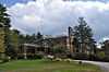 |
(#78000197) |
616 High St. 43°54′19″N 69°49′23″W / 43.905278°N 69.823056°W |
Bath | |
| 24 | Charles H. Ingraham Cottage | Upload image | (#86003512) |
Off State Route 209 43°44′53″N 69°47′17″W / 43.748056°N 69.788056°W |
Phippsburg | |
| 25 | Kennebec River Light Station | 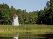 |
(#87002263) |
Fiddler Reach, Arrowsic Island 43°52′59″N 69°47′46″W / 43.883056°N 69.796111°W |
Arrowsic | Listed as being in Bath vicinity. |
| 26 | Gov. William King House | 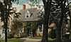 |
(#76000112) |
Whiskeag Rd. 43°55′58″N 69°49′25″W / 43.932778°N 69.823611°W |
Bath | |
| 27 | Joseph and Susan Manley Summer Cottage | Upload image | (#97001642) |
Eastern side of Club Rd., 0.1 miles south of its junction with State Route 216 and Club Rd. 43°43′24″N 69°50′14″W / 43.723333°N 69.837222°W |
Small Point | |
| 28 | McCobb-Hill-Minott House | 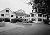 |
(#77000083) |
Parker Head Rd. 43°49′10″N 69°48′43″W / 43.819444°N 69.811944°W |
Phippsburg | |
| 29 | Captain Merritt House | 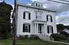 |
(#85000243) |
619 High St. 43°54′33″N 69°49′14″W / 43.909167°N 69.820556°W |
Bath | |
| 30 | Mill Cove School | Upload image | (#00000763) |
Western side of Berrys Mill Rd., 0.1 miles south of its junction with Hill Rd. 43°52′52″N 69°51′03″W / 43.881111°N 69.850833°W |
West Bath | Listed as being in Bath vicinity. |
| 31 | Peacock Tavern | Upload image | (#86000675) |
U.S. Route 201 44°09′33″N 69°51′42″W / 44.159167°N 69.861667°W |
Richmond | |
| 32 | Pejepscot Paper Company | 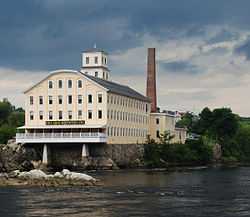 |
(#74000192) |
Off U.S. Route 201 at the Androscoggin River 43°55′18″N 69°57′53″W / 43.921667°N 69.964722°W |
Topsham | Also known as Bowdoin Mill |
| 33 | Pejepscot Site | Upload image | (#87000922) |
Address Restricted |
Pejepscot | |
| 34 | Percy and Small Shipyard | 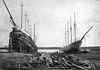 |
(#71000043) |
451 Washington St. 43°53′41″N 69°49′08″W / 43.894722°N 69.818889°W |
Bath | This is now the main campus of the Maine Maritime Museum. |
| 35 | Percy District School House, (Former) | Upload image | (#99000377) |
Junction of Parker Head Rd. and Cox Head Rd. 43°46′04″N 69°48′06″W / 43.767778°N 69.801667°W |
Parker Head | |
| 36 | Perkins Island Light Station | 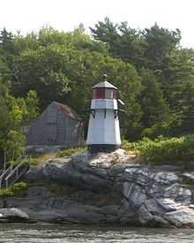 |
(#87002282) |
Perkins Island 43°47′12″N 69°47′09″W / 43.786667°N 69.785833°W |
Georgetown | |
| 37 | Popham Colony Site | 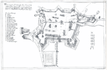 |
(#70000063) |
near Fort Popham 43°45′12″N 69°47′18″W / 43.7532°N 69.7884°W |
Popham Beach | |
| 38 | Purinton Family Farm | Upload image | (#89000842) |
65 Elm St. 43°55′27″N 69°57′05″W / 43.924167°N 69.951389°W |
Topsham | |
| 39 | Randall-Hildreth House | Upload image | (#04001048) |
806 Foreside Rd. 43°56′58″N 69°53′42″W / 43.949444°N 69.895°W |
Topsham | |
| 40 | Robert Reed House | Upload image | (#82000777) |
State Route 128 and Chop Point Rd. 44°00′16″N 69°48′34″W / 44.004444°N 69.809444°W |
Woolwich | |
| 41 | Richmond Historic District |  |
(#73000146) |
Roughly bounded by South, High, and Kimbal Sts., and the Kennebec River 44°05′08″N 69°48′15″W / 44.085556°N 69.804167°W |
Richmond | |
| 42 | Benjamin Riggs House |  |
(#88003008) |
Robinhood Rd. 43°51′13″N 69°44′12″W / 43.853611°N 69.736667°W |
Georgetown | |
| 43 | Riggs-Zorach House | Upload image | (#88003007) |
Off Robinhood Rd. 43°50′51″N 69°44′11″W / 43.8475°N 69.736389°W |
Georgetown | |
| 44 | Ropes End | Upload image | (#01001421) |
36 Hyde Rd. 43°43′24″N 69°50′12″W / 43.723333°N 69.836667°W |
Phippsburg | |
| 45 | Seguin Island Light Station | 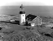 |
(#77000084) |
South of Georgetown 43°42′32″N 69°45′29″W / 43.708889°N 69.758056°W |
Georgetown | |
| 46 | SEGUIN (tugboat) | 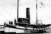 |
(#69000013) |
Maine Maritime Museum 43°53′39″N 69°48′59″W / 43.8942°N 69.8163°W |
Bath | Remnants stored at museum after failed restoration attempt.[6] |
| 47 | Small Point Club | Upload image | (#99000376) |
Club Rd., 0.3 miles south of its junction with State Route 216 and Club Rd. 43°43′16″N 69°50′14″W / 43.721111°N 69.837222°W |
Small Point | |
| 48 | Southard Block | 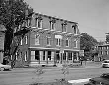 |
(#72000079) |
25 Front St. 44°05′26″N 69°51′09″W / 44.090556°N 69.8525°W |
Richmond | |
| 49 | Squirrel Point Light Station | 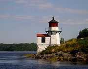 |
(#87002281) |
Squirrel Point, Arrowsic Island 43°48′59″N 69°48′10″W / 43.816389°N 69.802778°W |
Phippsburg | |
| 50 | Stone Schoolhouse | Upload image | (#77000085) |
South of Georgetown on Bay Point Rd. 43°46′45″N 69°45′54″W / 43.779167°N 69.765°W |
Georgetown | |
| 51 | Swan Island Historic District | Upload image | (#95001461) |
Kennebec River between Richmond and Dresden 44°03′32″N 69°47′59″W / 44.058889°N 69.799722°W |
Perkins Township | |
| 52 | Topsham Fairgrounds Grandstand | Upload image | (#92000277) |
Off the northern side of Elm St., east of its junction with Fair Cir. 43°55′38″N 69°57′12″W / 43.927222°N 69.953333°W |
Topsham | |
| 53 | Topsham Historic District | 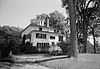 |
(#78000198) |
Elm, Main, and Green Sts. 43°55′35″N 69°57′30″W / 43.926389°N 69.958333°W |
Topsham | |
| 54 | Trufant Historic District | 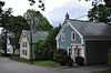 |
(#03001402) |
Portions of Corliss, Highland, Middle, Pine, and Washington Sts. 43°54′02″N 69°49′05″W / 43.900556°N 69.818056°W |
Bath | |
| 55 | U.S. Customhouse and Post Office | 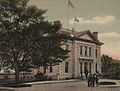 |
(#70000064) |
25 Front St. 43°54′43″N 69°48′56″W / 43.911944°N 69.815556°W |
Bath | |
| 56 | Winter Street Church | 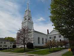 |
(#71000044) |
Corner of Washington and Winter Sts. 43°54′58″N 69°49′07″W / 43.916111°N 69.818611°W |
Bath | |
| 57 | Woolwich Town House |  |
(#78000199) |
Northeast of Bath at Old Stage and Dana Mills Rds. 43°58′10″N 69°46′12″W / 43.969444°N 69.77°W |
Woolwich |
See also
| Wikimedia Commons has media related to National Register of Historic Places in Sagadahoc County, Maine. |
References
- ↑ The latitude and longitude information provided in this table was derived originally from the National Register Information System, which has been found to be fairly accurate for about 99% of listings. For about 1% of NRIS original coordinates, experience has shown that one or both coordinates are typos or otherwise extremely far off; some corrections may have been made. A more subtle problem causes many locations to be off by up to 150 yards, depending on location in the country: most NRIS coordinates were derived from tracing out latitude and longitudes off of USGS topographical quadrant maps created under the North American Datum of 1927, which differs from the current, highly accurate WGS84 GPS system used by most on-line maps. Chicago is about right, but NRIS longitudes in Washington are higher by about 4.5 seconds, and are lower by about 2.0 seconds in Maine. Latitudes differ by about 1.0 second in Florida. Some locations in this table may have been corrected to current GPS standards.
- ↑ "National Register of Historic Places: Weekly List Actions". National Park Service, United States Department of the Interior. Retrieved on May 1, 2015.
- ↑ Numbers represent an ordering by significant words. Various colorings, defined here, differentiate National Historic Landmarks and historic districts from other NRHP buildings, structures, sites or objects.
- ↑ "National Register Information System". National Register of Historic Places. National Park Service. 2008-04-24.
- ↑ The eight-digit number below each date is the number assigned to each location in the National Register Information System database, which can be viewed by clicking the number.
- ↑ "Cultural Resource Management Bulletin (PDF pages 15-16)" (PDF). National Park Service. Retrieved 2014-09-17.
| ||||||||||||||||||||||||||
| |||||||||||||||||||||||||||||