National Register of Historic Places listings in Rutherford County, Tennessee
Location of Rutherford County in Tennessee
This is a list of the National Register of Historic Places listings in Rutherford County, Tennessee.
This is intended to be a complete list of the properties and districts on the National Register of Historic Places in Rutherford County, Tennessee, United States. Latitude and longitude coordinates are provided for many National Register properties and districts; these locations may be seen together in a Google map.[1]
There are 47 properties and districts listed on the National Register in the county, and five former listings.
| Anderson – Bedford – Benton – Bledsoe – Blount – Bradley – Campbell – Cannon – Carroll – Carter – Cheatham – Chester – Claiborne – Clay – Cocke – Coffee – Crockett – Cumberland – Davidson – Decatur – DeKalb – Dickson – Dyer – Fayette – Fentress – Franklin – Gibson – Giles – Grainger – Greene – Grundy – Hamblen – Hamilton – Hancock – Hardeman – Hardin – Hawkins – Haywood – Henderson – Henry – Hickman – Houston – Humphreys – Jackson – Jefferson – Johnson – Knox – Lake – Lauderdale – Lawrence – Lewis – Lincoln – Loudon – Macon – Madison – Marion – Marshall – Maury – McMinn – McNairy – Meigs – Monroe – Montgomery – Moore – Morgan – Obion – Overton – Perry – Pickett – Polk – Putnam – Rhea – Roane – Robertson – Rutherford – Scott – Sequatchie – Sevier – Shelby – Smith – Stewart – Sullivan – Sumner – Tipton – Trousdale – Unicoi – Union – Van Buren – Warren – Washington – Wayne – Weakley – White – Williamson – Wilson |
- This National Park Service list is complete through NPS recent listings posted May 1, 2015.[2]
Current listings
| [3] | Name on the Register[4] | Image | Date listed[5] | Location | City or town | Description |
|---|---|---|---|---|---|---|
| 1 | Allen Chapel A.M.E. Church | 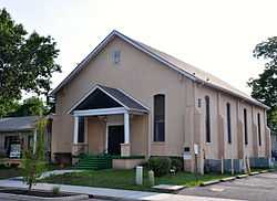 |
(#95000291) |
224 S. Maney Ave. 35°50′38″N 86°23′14″W / 35.843889°N 86.387222°W |
Murfreesboro | |
| 2 | Arnold-Harrell House | 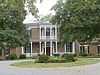 |
(#92000145) |
1710 E. Main St. 35°50′26″N 86°21′51″W / 35.840556°N 86.364167°W |
Murfreesboro | |
| 3 | Beesley Primitive Baptist Church | 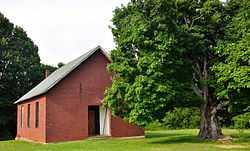 |
(#99000397) |
461 Beesley Rd. 35°51′11″N 86°29′51″W / 35.853056°N 86.4975°W |
Murfreesboro | |
| 4 | Thomas C. Black House | Upload image | (#96000231) |
4431 Lebanon Rd. 35°55′38″N 86°22′58″W / 35.927222°N 86.382778°W |
Murfreesboro | |
| 5 | Boxwood | 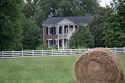 |
(#84000139) |
Old Salem Pike 35°48′37″N 86°27′09″W / 35.810278°N 86.4525°W |
Murfreesboro | |
| 6 | Bradley Academy | 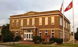 |
(#90000914) |
415 S. Academy St. 35°50′31″N 86°23′19″W / 35.841944°N 86.388611°W |
Murfreesboro | School established 1811; current building completed in 1917 |
| 7 | Caff-E-Hill Farm | Upload image | (#95000412) |
3783 Cripple Creek Rd. 35°46′42″N 86°11′53″W / 35.778333°N 86.198056°W |
Readyville | |
| 8 | Childress-Ray House | 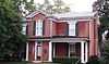 |
(#79002458) |
225 N. Academy St. 35°50′51″N 86°23′19″W / 35.8475°N 86.388611°W |
Murfreesboro | Originally built 1847; remodeled 1874 |
| 9 | Collier-Crichlow House | 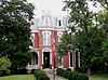 |
(#73001822) |
511 E. Main St. 35°50′42″N 86°22′18″W / 35.845°N 86.371667°W |
Murfreesboro | Second Empire-style house built in 1879 |
| 10 | Collier-Lane-Crichlow House | 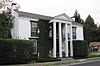 |
(#78002629) |
500 N. Spring St. 35°51′00″N 86°23′21″W / 35.85°N 86.389167°W |
Murfreesboro | Commonly called the "House of Mayors"; built in 1850 |
| 11 | Sam Davis House | 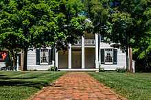 |
(#69000181) |
Northeast of Smyrna off State Route 102 35°59′21″N 86°29′56″W / 35.989167°N 86.498889°W |
Smyrna | |
| 12 | Dement House | Upload image | (#86001379) |
Cainsville Pike 35°55′56″N 86°16′01″W / 35.932222°N 86.266944°W |
Lascassas | |
| 13 | East Main Street Historic District | 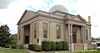 |
(#85001516) |
Roughly E. Main, E. Lytle, College, University, and E. Vine Sts. 35°50′42″N 86°22′50″W / 35.845°N 86.380556°W |
Murfreesboro | |
| 14 | Elmwood | Upload image | (#73001823) |
Northwest of Murfreesboro off U.S. Routes 41/70S; also 5722 Old Nashville Highway 35°53′46″N 86°27′28″W / 35.896111°N 86.457778°W |
Murfreesboro | 5722 Old Nashville Highway represents a boundary increase of July 3, 2007 |
| 15 | First Presbyterian Church | 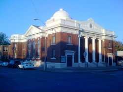 |
(#93000561) |
210 N. Spring St. 35°50′49″N 86°23′23″W / 35.846944°N 86.389722°W |
Murfreesboro | |
| 16 | Fortress Rosecrans Site | 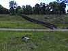 |
(#74001926) |
Old Fort Parkway west of downtown Murfreesboro at the Stones River 35°51′12″N 86°24′41″W / 35.853333°N 86.411389°W |
Murfreesboro | |
| 17 | Logan Henderson Farm |  |
(#03000971) |
3600 Manchester Pike 35°47′27″N 86°21′25″W / 35.790833°N 86.356944°W |
Murfreesboro | |
| 18 | Idler's Retreat |  |
(#04000475) |
112 Oak St. 35°59′15″N 86°30′55″W / 35.9875°N 86.515278°W |
Smyrna | |
| 19 | Jarman Farm | Upload image | (#87001368) |
Cainsville Pike 35°57′46″N 86°15′30″W / 35.962778°N 86.258333°W |
Lascassas | |
| 20 | Enoch H. Jones House | Upload image | (#95001043) |
6339 Halls Hill Pike 35°51′39″N 86°13′04″W / 35.860833°N 86.217778°W |
Murfreesboro | |
| 21 | William B. Jordan Farm | Upload image | (#92000825) |
2665 Taylor Ln. 35°46′03″N 86°36′10″W / 35.7675°N 86.602778°W |
Eagleville | |
| 22 | Landsberger-Gerhardt House | Upload image | (#93001397) |
435 N. Spring St. 35°51′00″N 86°23′21″W / 35.85°N 86.389167°W |
Murfreesboro | |
| 23 | Uncle Dave Macon House |  |
(#73001827) |
West of Readyville on U.S. Route 70S 35°49′27″N 86°14′27″W / 35.824167°N 86.240833°W |
Readyville | Home of banjoist and showman Uncle Dave Macon |
| 24 | Marymont |  |
(#73001824) |
Southwest of Murfreesboro, off State Route 99 on Rucker Lane 35°49′12″N 86°28′45″W / 35.82°N 86.479167°W |
Murfreesboro | |
| 25 | William Harrison McCord House | Upload image | (#84001121) |
U.S. Route 41A 35°44′46″N 86°39′06″W / 35.746111°N 86.651667°W |
Eagleville | |
| 26 | McGill – Becton – Cates Family Farm | Upload image | (#05001220) |
2432 Cripple Creek Rd. 35°47′03″N 86°12′41″W / 35.784167°N 86.211389°W |
Readyville | |
| 27 | Middle Tennessee State Teachers College Training School | 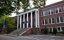 |
(#92001731) |
923 E. Lytle St. 35°50′49″N 86°22′31″W / 35.846944°N 86.375278°W |
Murfreesboro | |
| 28 | Morgan House | 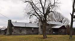 |
(#79002457) |
Southwest of Christiana 35°39′22″N 86°27′27″W / 35.656111°N 86.4575°W |
Christiana | |
| 29 | Murfreesboro Veterans Administration Hospital Historic District | Upload image | (#12000119) |
3400 Lebanon Pike 35°55′00″N 86°22′41″W / 35.916625°N 86.378054°W |
Murfreesboro | United States Second Generation Veterans Hospitals Multiple Property Submission |
| 30 | Murray Farm | Upload image | (#91000980) |
9409 Bradyville Rd. 35°45′21″N 86°15′49″W / 35.755833°N 86.263611°W |
Readyville | |
| 31 | North Maney Avenue Historic District | Upload image | (#85000709) |
Roughly bounded by N. Maney and N. Highland Aves., E. College St., and N. Academy Ave. 35°50′55″N 86°23′10″W / 35.848611°N 86.386111°W |
Murfreesboro | |
| 32 | Oaklands | .jpg) |
(#70000616) |
N. Maney Ave. 35°51′21″N 86°23′06″W / 35.855833°N 86.385°W |
Murfreesboro | |
| 33 | Old First Presbyterian Church and Old City Cemetery | 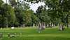 |
(#12000120) |
390 E. Vine St. 35°50′37″N 86°23′16″W / 35.843508°N 86.387871°W |
Murfreesboro | Cemetery dating to the 1820s and site of the original First Presbyterian Church in Murfreesboro which was destroyed by Union Army troops during the American Civil War[6] |
| 34 | Gen. Joseph B. Palmer House | 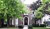 |
(#73001825) |
434 E. Main St. 35°50′43″N 86°23′07″W / 35.845278°N 86.385278°W |
Murfreesboro | Built in 1869 by Confederate general Joseph B. Palmer (1825–1890) |
| 35 | Providence Primitive Baptist Church | Upload image | (#00001357) |
256 Central Valley Rd. 35°56′19″N 86°22′51″W / 35.938611°N 86.380833°W |
Walterhill | |
| 36 | Charles Ready House | 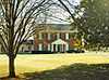 |
(#73001828) |
On U.S. Route 70S 35°49′45″N 86°10′47″W / 35.829167°N 86.179722°W |
Readyville | Known as "The Corners," built in 1829 by Charles Ready |
| 37 | Riverside Farm | Upload image | (#06001132) |
1218 W. Jefferson Pike 35°57′55″N 86°23′21″W / 35.965278°N 86.389167°W |
Walterhill | |
| 38 | Rockvale Store | Upload image | (#95001114) |
8964 Rockvale Rd. 35°45′27″N 86°31′53″W / 35.7575°N 86.531389°W |
Rockvale | |
| 39 | Benjamine Rucker House | Upload image | (#91000223) |
3978 Betty Ford Rd. 35°55′14″N 86°19′51″W / 35.920556°N 86.330833°W |
Compton | |
| 40 | Rutherford County Courthouse | 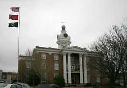 |
(#73001826) |
Public Square 35°50′46″N 86°23′31″W / 35.846111°N 86.391944°W |
Murfreesboro | |
| 41 | Rutherford Health Department | 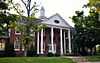 |
(#92000960) |
303 N. Church St. 35°50′54″N 86°23′27″W / 35.848333°N 86.390833°W |
Murfreesboro | |
| 42 | Absalom Scales House | Upload image | (#73001821) |
North of Eagleville off State Route 16, on Rocky Glade Rd. 35°46′27″N 86°38′22″W / 35.774167°N 86.639444°W |
Eagleville | |
| 43 | Searcy – Matthews – Tarpley Farm | Upload image | (#11000459) |
455 W. Jefferson Pike 35°57′08″N 86°23′07″W / 35.952222°N 86.385278°W |
Walterhill | Historic Family Farms in Middle Tennessee MPS |
| 44 | Robert Andrew Smith Farm | Upload image | (#92001712) |
2568 Armstrong Valley Rd. 35°46′06″N 86°28′45″W / 35.768333°N 86.479167°W |
Murfreesboro | |
| 45 | John C. Spence House | 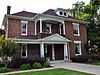 |
(#04000302) |
503 N. Maple St. 35°51′10″N 86°23′32″W / 35.852778°N 86.392222°W |
Murfreesboro | |
| 46 | Stones River National Battlefield |  |
(#66000075) |
3 miles (4.8 km) northwest of Murfreesboro on U.S. Route 41 35°52′24″N 86°25′17″W / 35.873333°N 86.421389°W |
Murfreesboro | |
| 47 | Walter Hill Hydroelectric Station | Upload image | (#90001660) |
U.S. Route 231 at the Stones River 35°56′37″N 86°22′37″W / 35.943611°N 86.376944°W |
Murfreesboro |
Former listings
Four other properties have previously been listed, but were removed:
| [3] | Name on the Register | Image | Date listed | Date removed | Location | City or town | Summary |
|---|---|---|---|---|---|---|---|
| 1 | Brown's Mill | Upload image | (#78002628) | SE of Lascassas on Brown's Mill Road |
Lascassas | ||
| 2 | Crichlow Grammar School and E. C. Cox Memorial Gym | Upload image | (#92001685) | 400 N. Maple St. and 105 Olive St. |
Murfreesboro | ||
| 3 | Hiram Jenkins House | Upload image | (#89000504) | 1556 Gresham Lane |
Murfreesboro | ||
| 4 | Ridley's Landing | Upload image | (#73001829) | N of Smyrna on Jones Mill Rd., at Stones River |
Smyrna vicinity | ||
| 5 | Thomas Williamson House | Upload image | (#96000687) | 2263 Little Rock Rd. 35°44′58″N 86°37′17″W / 35.749444°N 86.621389°W |
Eagleville |
See also
| Wikimedia Commons has media related to National Register of Historic Places in Rutherford County, Tennessee. |
- List of National Historic Landmarks in Tennessee
- National Register of Historic Places listings in Tennessee
References
- ↑ The latitude and longitude information provided in this table was derived originally from the National Register Information System, which has been found to be fairly accurate for about 99% of listings. For about 1% of NRIS original coordinates, experience has shown that one or both coordinates are typos or otherwise extremely far off; some corrections may have been made. A more subtle problem causes many locations to be off by up to 150 yards, depending on location in the country: most NRIS coordinates were derived from tracing out latitude and longitudes off of USGS topographical quadrant maps created under the North American Datum of 1927, which differs from the current, highly accurate WGS84 GPS system used by most on-line maps. Chicago is about right, but NRIS longitudes in Washington are higher by about 4.5 seconds, and are lower by about 2.0 seconds in Maine. Latitudes differ by about 1.0 second in Florida. Some locations in this table may have been corrected to current GPS standards.
- ↑ "National Register of Historic Places: Weekly List Actions". National Park Service, United States Department of the Interior. Retrieved on May 1, 2015.
- ↑ 3.0 3.1 Numbers represent an ordering by significant words. Various colorings, defined here, differentiate National Historic Landmarks and historic districts from other NRHP buildings, structures, sites or objects.
- ↑ "National Register Information System". National Register of Historic Places. National Park Service. 2008-04-24.
- ↑ The eight-digit number below each date is the number assigned to each location in the National Register Information System database, which can be viewed by clicking the number.
- ↑ West, Mike. "Union army destroyed historic church". Murfreesboro Post. Retrieved March 26, 2012.
| ||||||||||||||||||||||||||
| |||||||||||||||||||||||||||||