National Register of Historic Places listings in Rogers County, Oklahoma

Location of Rogers County in Oklahoma
This is a list of the National Register of Historic Places listings in Rogers County, Oklahoma.
This is intended to be a complete list of the properties and districts on the National Register of Historic Places in Rogers County, Oklahoma, United States. The locations of National Register properties and districts for which the latitude and longitude coordinates are included below, may be seen in a Google map.[1]
There are 16 properties and districts listed on the National Register in the county.
- This National Park Service list is complete through NPS recent listings posted May 1, 2015.[2]
Current listings
| [3] |
Name on the Register[4] |
Image |
Date listed[5] |
Location |
City or town |
Description |
|---|
| 1 |
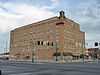
I.W.W. Beck Building |
Upload image |
01999-09-10-0000September 10, 1999
(#99001086) |
146 W. Cooweescoowee Ave.
36°26′50″N 95°42′31″W / 36.447222°N 95.708611°W / 36.447222; -95.708611 (I.W.W. Beck Building) |
Oologah |
|
| 2 |
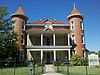
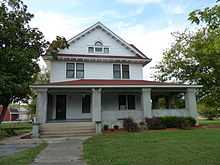
The Belvidere |
|
01982-03-24-0000March 24, 1982
(#82003696) |
109 N. Chickasaw Ave.
36°18′39″N 95°36′37″W / 36.310833°N 95.610278°W / 36.310833; -95.610278 (The Belvidere) |
Claremore |
|
| 3 |
Chelsea Motel |
|
02004-05-27-0000May 27, 2004
(#04000525) |
Junction of 1st and State Highway 66
36°32′15″N 95°25′33″W / 36.5375°N 95.425833°W / 36.5375; -95.425833 (Chelsea Motel) |
Chelsea |
|
| 4 |
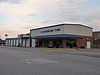
Claremore Auto Dealership |
|
01995-02-23-0000February 23, 1995
(#95000042) |
625 W. Will Rogers Boulevard
36°18′46″N 95°37′02″W / 36.312778°N 95.617222°W / 36.312778; -95.617222 (Claremore Auto Dealership) |
Claremore |
|
| 5 |
Eastern University Preparatory School |
|
01982-02-19-0000February 19, 1982
(#82003697) |
College Hill
36°19′12″N 95°38′07″W / 36.32°N 95.635278°W / 36.32; -95.635278 (Eastern University Preparatory School) |
Claremore |
|
| 6 |
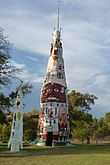
Ed Galloway's Totem Pole Park |
|
01999-03-30-0000March 30, 1999
(#99000354) |
State Highway 28A, 3.5 miles east of the former U.S. Route 66
36°26′14″N 95°26′53″W / 36.437222°N 95.448056°W / 36.437222; -95.448056 (Ed Galloway's Totem Pole Park) |
Foyil |
|
| 7 |
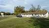
Hanes Home |
Upload image |
01982-07-12-0000July 12, 1982
(#82003700) |
Off State Highway 88
36°20′04″N 95°39′06″W / 36.334444°N 95.651667°W / 36.334444; -95.651667 (Hanes Home) |
Sageeyah |
|
| 8 |
Hogue House |
|
01982-12-17-0000December 17, 1982
(#82001498) |
1001 S. Olive St.
36°31′52″N 95°26′03″W / 36.531111°N 95.434167°W / 36.531111; -95.434167 (Hogue House) |
Chelsea |
|
| 9 |
Mendenhall's Bath House |
Upload image |
01983-03-23-0000March 23, 1983
(#83002127) |
601 E. 7th St.
36°18′39″N 95°36′02″W / 36.310833°N 95.600556°W / 36.310833; -95.600556 (Mendenhall's Bath House) |
Claremore |
|
| 10 |
Maurice Meyer Barracks |
Upload image |
01982-03-01-0000March 1, 1982
(#82003698) |
College Hill
36°19′08″N 95°38′07″W / 36.318889°N 95.635278°W / 36.318889; -95.635278 (Maurice Meyer Barracks) |
Claremore |
|
| 11 |
Oologah Bank |
Upload image |
01982-05-10-0000May 10, 1982
(#82003699) |
105 S. Maple St.
36°26′48″N 95°42′35″W / 36.446667°N 95.709722°W / 36.446667; -95.709722 (Oologah Bank) |
Oologah |
|
| 12 |
Oologah Pump |
Upload image |
01982-12-17-0000December 17, 1982
(#82001499) |
Maple and Cooweescoowee Sts.
36°26′48″N 95°42′35″W / 36.446667°N 95.709722°W / 36.446667; -95.709722 (Oologah Pump) |
Oologah |
|
| 13 |
Pryor Creek Bridge |
|
02006-09-06-0000September 6, 2006
(#06000796) |
Carries 1st St. over Pryor Creek, southwest of its junction with State Highway 66
36°32′18″N 95°24′54″W / 36.538333°N 95.415°W / 36.538333; -95.415 (Pryor Creek Bridge) |
Chelsea |
|
| 14 |
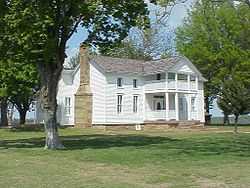
Will Rogers Birthplace |
|
01970-09-29-0000September 29, 1970
(#70000538) |
About 4 miles northeast of Oologah
36°28′10″N 95°39′26″W / 36.469444°N 95.657222°W / 36.469444; -95.657222 (Will Rogers Birthplace) |
Oologah |
|
| 15 |
Will Rogers Hotel |
|
01994-12-29-0000December 29, 1994
(#94001508) |
524 W. Will Rogers Boulevard
36°18′45″N 95°36′55″W / 36.3125°N 95.615278°W / 36.3125; -95.615278 (Will Rogers Hotel) |
Claremore |
|
| 16 |
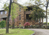
Verdigris Club Lodge |
|
02003-09-02-0000September 2, 2003
(#03000876) |
27795 S. Skelly Dr.
36°12′43″N 95°37′44″W / 36.211944°N 95.628889°W / 36.211944; -95.628889 (Verdigris Club Lodge) |
Catoosa |
|
See also
References
- ↑ The latitude and longitude information provided in this table was derived originally from the National Register Information System, which has been found to be fairly accurate for about 99% of listings. For about 1% of NRIS original coordinates, experience has shown that one or both coordinates are typos or otherwise extremely far off; some corrections may have been made. A more subtle problem causes many locations to be off by up to 150 yards, depending on location in the country: most NRIS coordinates were derived from tracing out latitude and longitudes off of USGS topographical quadrant maps created under the North American Datum of 1927, which differs from the current, highly accurate WGS84 GPS system used by most on-line maps. Chicago is about right, but NRIS longitudes in Washington are higher by about 4.5 seconds, and are lower by about 2.0 seconds in Maine. Latitudes differ by about 1.0 second in Florida. Some locations in this table may have been corrected to current GPS standards.
- ↑ "National Register of Historic Places: Weekly List Actions". National Park Service, United States Department of the Interior. Retrieved on May 1, 2015.
- ↑ Numbers represent an ordering by significant words. Various colorings, defined here, differentiate National Historic Landmarks and historic districts from other NRHP buildings, structures, sites or objects.
- ↑ "National Register Information System". National Register of Historic Places. National Park Service. 2009-03-13.
- ↑ The eight-digit number below each date is the number assigned to each location in the National Register Information System database, which can be viewed by clicking the number.
|
|---|
| | Topics | |
|---|
| | Lists by states | |
|---|
| | Lists by insular areas | |
|---|
| | Lists by associated states | |
|---|
| | Other areas | |
|---|
|
-
 Category Category
-
 Portal Portal
-
 WikiProject WikiProject
|
|