National Register of Historic Places listings in Rock County, Wisconsin
Buildings, sites, structures, districts, and objects in Rock County listed on the National Register of Historic Places
- This National Park Service list is complete through NPS recent listings posted May 1, 2015.[1]
Current listings
| [2] | Name on the Register[3] | Image | Date listed[4] | Location | City or town | Description |
|---|---|---|---|---|---|---|
| 1 | John Alexander Wheat Warehouse |  |
(#78003383) |
304 S. Janesville St. 42°46′29″N 88°56′11″W / 42.774722°N 88.936389°W |
Milton | |
| 2 | Abram Allen House |  |
(#78003386) |
205 E. Madison Ave. 42°46′45″N 88°56′54″W / 42.779167°N 88.948333°W |
Milton | |
| 3 | The Armory | Upload image | (#78000130) |
10 S. High St. 42°40′49″N 89°01′40″W / 42.680278°N 89.027778°W |
Janesville | |
| 4 | Bartlett Memorial Historical Museum | Upload image | (#77000048) |
2149 St. Lawrence Ave. 42°30′15″N 89°04′10″W / 42.504167°N 89.069444°W |
Beloit | |
| 5 | Beloit Water Tower |  |
(#83003410) |
1005 Pleasant St. 42°30′33″N 89°01′49″W / 42.509167°N 89.030278°W |
Beloit | |
| 6 | Benton Avenue Historic District | Upload image | (#96000251) |
Roughly bounded by Benton Ave., Wilton Ave., Sherman Ave., Richardson St., Blaine Ave. and Prairie Ave. 42°41′48″N 89°00′48″W / 42.696667°N 89.013333°W |
Janesville | |
| 7 | Selvy Blodgett House |  |
(#80000183) |
417 Bluff St. 42°29′59″N 89°02′29″W / 42.499722°N 89.041389°W |
Beloit | |
| 8 | Bluff Street Historic District | Upload image | (#83003411) |
Roughly both sides of Bluff St. from Shirland Ave. to Merrill St. 42°30′04″N 89°02′30″W / 42.501111°N 89.041667°W |
Beloit | |
| 9 | Bostwick Avenue Historic District | Upload image | (#06000321) |
404-436 Bostwick Ave. and 1118 and 1128 Grace St. 42°40′56″N 89°00′37″W / 42.682222°N 89.010278°W |
Janesville | |
| 10 | Brasstown Cottage |  |
(#83003412) |
1701 Colley Rd. 42°30′26″N 89°00′53″W / 42.507222°N 89.014722°W |
Beloit | |
| 11 | Church of St. Thomas the Apostle |  |
(#83003413) |
822 E. Grand Ave. 42°29′58″N 89°01′41″W / 42.499444°N 89.028056°W |
Beloit | |
| 12 | Citizens Bank |  |
(#85001661) |
Front & Allen Sts. 42°33′12″N 88°51′46″W / 42.553333°N 88.862778°W |
Clinton | |
| 13 | City of Beloit Waterworks and Pump Station |  |
(#90001460) |
1005 Pleasant St. 42°30′32″N 89°01′51″W / 42.508889°N 89.030833°W |
Beloit | |
| 14 | Clark-Brown House | Upload image | (#85002126) |
3457 Riverside Dr. 42°33′45″N 89°02′06″W / 42.5625°N 89.035°W |
Beloit | |
| 15 | Clinton Village Hall | 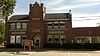 |
(#85001660) |
301 Cross St. 42°33′18″N 88°51′42″W / 42.555°N 88.861667°W |
Clinton | |
| 16 | Clinton Water Tower | 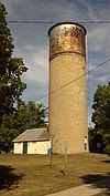 |
(#85000493) |
High St. 42°33′39″N 88°51′48″W / 42.560833°N 88.863333°W |
Clinton | |
| 17 | Columbus Circle Historic District | Upload image | (#05000453) |
Columbus Circle generally bounded by N. Adams and E. Milwaukee Sts. and N. Garfield Ave. 42°41′24″N 89°00′38″W / 42.69°N 89.010556°W |
Janesville | |
| 18 | Conrad Cottages Historic District | Upload image | (#93000157) |
235-330 Milton Ave. 42°41′12″N 89°01′03″W / 42.686667°N 89.0175°W |
Janesville | |
| 19 | Cooksville Cheese Factory |  |
(#80000395) |
SR 1 42°50′06″N 89°14′36″W / 42.835°N 89.243333°W |
Evansville | |
| 20 | Cooksville Historic District | 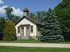 |
(#73000254) |
Both sides of streets bordering the Public Sq. and Rock St. 42°50′08″N 89°14′19″W / 42.835556°N 89.238611°W |
Cooksville | Boundary increase (listed September 17, 1980): Roughly Tolles Rd., Church St., Rock St., Dane St., and Main St. |
| 21 | Cooksville Mill and Mill Pond Site | Upload image | (#80000394) |
SR 1 42°50′19″N 89°14′32″W / 42.838611°N 89.242222°W |
Evansville | |
| 22 | Cooper-Gillies House |  |
(#80000397) |
SR 1 42°50′03″N 89°15′17″W / 42.834167°N 89.254722°W |
Evansville | |
| 23 | Court Street Methodist Church |  |
(#77000045) |
36 S. Main St. 42°40′55″N 89°01′17″W / 42.681944°N 89.021389°W |
Janesville | |
| 24 | Courthouse Hill Historic District | Upload image | (#86000205) |
Roughly bounded by E. Milwaukee St., Garfield and Oakland Aves., S. Main St., and E. Court St. and Milton Ave. 42°41′00″N 89°00′58″W / 42.683333°N 89.016111°W |
Janesville | |
| 25 | J. W. Crist House | Upload image | (#83003414) |
2601 Afton Rd. 42°32′26″N 89°03′04″W / 42.540556°N 89.051111°W |
Beloit | |
| 26 | Crosby Block |  |
(#85001658) |
102 Allen St. 42°33′12″N 88°51′46″W / 42.553333°N 88.862778°W |
Clinton | |
| 27 | James B. Crosby House | Upload image | (#95001454) |
1005 Sutherland Ave. 42°41′41″N 89°01′27″W / 42.694722°N 89.024167°W |
Janesville | |
| 28 | Charles L. Culton House | Upload image | (#77000046) |
708 Washington St. 42°50′19″N 89°04′34″W / 42.838611°N 89.076111°W |
Edgerton | |
| 29 | De Jean House |  |
(#78003388) |
27 Third St. 42°46′54″N 88°57′33″W / 42.781667°N 88.959167°W |
Milton | |
| 30 | Erastus Dean Farmstead | Upload image | (#78000131) |
E of Janesville on U.S. 14 42°39′20″N 88°52′50″W / 42.655556°N 88.880556°W |
Janesville | |
| 31 | Homer B. DeLong House |  |
(#85001659) |
500 Milwaukee Rd. 42°33′29″N 88°51′51″W / 42.558056°N 88.864167°W |
Clinton | |
| 32 | John T. Dow House |  |
(#80000396) |
SR 1 42°50′05″N 89°14′49″W / 42.834722°N 89.246944°W |
Evansville | |
| 33 | Eager Free Public Library | Upload image | (#77000047) |
39 W. Main St. 42°47′05″N 89°03′23″W / 42.784722°N 89.056389°W |
Evansville | |
| 34 | Almeron Eager Funerary Monument and Plot |  |
(#11000477) |
8012 N. Cemetery Rd. 42°46′59″N 89°17′21″W / 42.783056°N 89.289167°W |
Evansville | |
| 35 | East Milwaukee Street Historic District | Upload image | (#80000184) |
N. Parker Dr. and E. Milwaukee St. 42°41′01″N 89°01′18″W / 42.683611°N 89.021667°W |
Janesville | |
| 36 | Edgerton Depot | Upload image | (#98000283) |
20 S. Main St. 42°50′00″N 89°04′13″W / 42.833333°N 89.070278°W |
Edgerton | |
| 37 | Edgerton Post Office | Upload image | (#00001239) |
104 N. Swift St. 42°50′08″N 89°04′16″W / 42.835556°N 89.071111°W |
Edgerton | |
| 38 | Edgerton Public Grade Schools | Upload image | (#86003568) |
116 N. Swift St. 42°50′09″N 89°04′11″W / 42.835833°N 89.069722°W |
Edgerton | |
| 39 | Emerson Hall |  |
(#79000109) |
Beloit College campus 42°30′26″N 89°01′43″W / 42.507222°N 89.028611°W |
Beloit | |
| 40 | Evansville Historic District | Upload image | (#78000132) |
roughly bounded by Allens Creek, Liberty, 4th and Garfield Sts. 42°46′46″N 89°18′10″W / 42.779444°N 89.302778°W |
Evansville | |
| 41 | Evansville Standpipe | 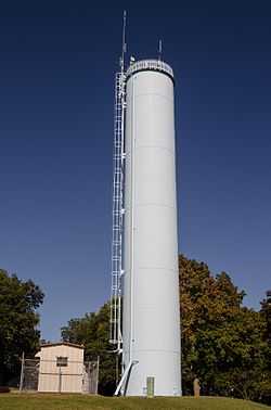 |
(#08000120) |
288 N. 4th St. 42°47′05″N 89°18′47″W / 42.784722°N 89.313056°W |
Evansville | |
| 42 | Fairbanks Flats | Upload image | (#83003416) |
205, 215 Birch Ave. and 206, 216 Carpenter Ave. 42°31′19″N 89°02′24″W / 42.521944°N 89.04°W |
Beloit | |
| 43 | First Congregational Church | 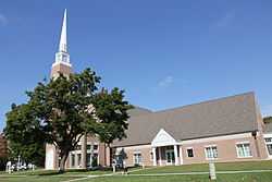 |
(#75000078) |
801 Bushnell St. 42°30′06″N 89°01′40″W / 42.501667°N 89.027778°W |
Beloit | |
| 44 | Footville Condensery | Upload image | (#82000704) |
Beloit St. 42°40′00″N 89°12′27″W / 42.666667°N 89.2075°W |
Footville | |
| 45 | Footville State Bank | Upload image | (#82000705) |
158 Depot St. 42°40′11″N 89°12′40″W / 42.669722°N 89.211111°W |
Footville | |
| 46 | Fredendall Block | Upload image | (#82000706) |
33-39 S. Main St. 42°40′56″N 89°01′17″W / 42.682222°N 89.021389°W |
Janesville | |
| 47 | Fulton Congregational Church | Upload image | (#76000077) |
Fulton St. 42°48′21″N 89°07′44″W / 42.805833°N 89.128889°W |
Fulton | |
| 48 | Fulton Street Historic District | Upload image | (#99000788) |
Along Fulton St., roughly bounded by Main ans Albion Sts.; 11-21 Swift St. 42°50′03″N 89°04′13″W / 42.834167°N 89.070278°W |
Edgerton | |
| 49 | Gempeler Round Barn | Upload image | (#79000110) |
SW of Orfordville 42°39′50″N 89°19′50″W / 42.663889°N 89.330556°W |
Orfordville | |
| 50 | Gifford House |  |
(#78003387) |
308 Vernal 42°46′51″N 88°57′36″W / 42.780833°N 88.96°W |
Milton | |
| 51 | Gilley-Tofsland Octagonal Barn | Upload image | (#79000111) |
NW of Edgerton 42°50′40″N 89°10′30″W / 42.844444°N 89.175°W |
Edgerton | |
| 52 | Goodrich Blacksmith Shop | Upload image | (#78003382) |
28 S. Janesville St. 42°46′34″N 88°56′10″W / 42.776111°N 88.936111°W |
Milton | |
| 53 | Goodrich-Buten House |  |
(#78003385) |
528 E. Madison St. 42°46′38″N 88°56′22″W / 42.777222°N 88.939444°W |
Milton | |
| 54 | Grove Street Historic District | Upload image | (#11000531) |
103, 111, 112, 116, 119, 125, 126, 133 & 134 Grove St. 42°47′00″N 89°18′08″W / 42.783464°N 89.302222°W |
Evansville | NRHP # 11000531 |
| 55 | Hanchett Block |  |
(#80000185) |
307 State St. 42°29′56″N 89°02′08″W / 42.498889°N 89.035556°W |
Beloit | |
| 56 | Hilton House Hotel | Upload image | (#03001128) |
434 E. Grand Ave. 42°29′58″N 89°02′02″W / 42.499444°N 89.033889°W |
Beloit | |
| 57 | How-Beckman Mill |  |
(#77000049) |
Address Restricted |
Beloit | |
| 58 | John and Martha Hugunin House | Upload image | (#05000534) |
2739 Beloit Ave. 42°38′30″N 89°00′41″W / 42.641667°N 89.011389°W |
Janesville | |
| 59 | Janesville Cotton Mill | Upload image | (#80000186) |
220 N. Franklin St. 42°41′02″N 89°01′39″W / 42.683889°N 89.0275°W |
Janesville | |
| 60 | Janesville High School | Upload image | (#99000760) |
408 S. Main St. 42°40′40″N 89°01′02″W / 42.677778°N 89.017222°W |
Janesville | Also known as Marshall Junior High School |
| 61 | Janesville Public Library |  |
(#81000057) |
64 S. Main St. 42°40′53″N 89°01′15″W / 42.681389°N 89.020833°W |
Janesville | |
| 62 | Janesville Pumping Station | Upload image | (#85000494) |
500 Blk. River St. 42°40′48″N 89°01′22″W / 42.68°N 89.022778°W |
Janesville | |
| 63 | Jefferson Avenue Historic District | Upload image | (#06000300) |
Bounded by Oakland, Garfield and Ruger Aves. and Forest Park Blvd. 42°41′10″N 89°00′40″W / 42.686111°N 89.011111°W |
Janesville | |
| 64 | John H. Jones House | Upload image | (#08000186) |
538 S. Main St. 42°40′36″N 89°00′56″W / 42.676667°N 89.015556°W |
Janesville | |
| 65 | Samuel S. Jones Cobblestone House |  |
(#78000133) |
E of Clinton on Milwaukee Rd. 42°33′57″N 88°49′02″W / 42.565833°N 88.817222°W |
Clinton | |
| 66 | Kinney Farmstead-Tay-e-he-Dah Site | |
(#78000134) |
Address Restricted |
Edgerton | |
| 67 | Lappin-Hayes Block | Upload image | (#76000224) |
20 E. Milwaukee St. 42°40′58″N 89°01′21″W / 42.682778°N 89.0225°W |
Janesville | |
| 68 | LaPrairie Grange Hall No. 79 | Upload image | (#77000050) |
SE of Janesville on Town Hall Rd. 42°37′37″N 88°57′12″W / 42.626944°N 88.953333°W |
Janesville | |
| 69 | Lathrop-Munn Cobblestone House |  |
(#77000051) |
524 Bluff St. 42°30′03″N 89°02′31″W / 42.500833°N 89.041944°W |
Beloit | |
| 70 | Leonard—Leota Park | Upload image | (#12000610) |
20, 30, 40, 50, ca 60, 120, 121 Antes Dr., 321, 340, 359, 360, 363, 365, 395 Burr W. Jones Cir., Leonard Park Dr. 42°47′07″N 89°18′06″W / 42.785362°N 89.30164°W |
Evansville | |
| 71 | Look West Historic District | Upload image | (#87000506) |
Roughly bounded by Mineral Point Ave., N. Franklin and Race Sts., Laurel Ave., and N. Chatham St. 42°41′03″N 89°02′00″W / 42.684167°N 89.033333°W |
Janesville | Boundary increase (listed December 10, 1993): Roughly bounded by Laurel Ave. and N. Madison, W. Court and N. Palm Sts. |
| 72 | Lovejoy and Merrill-Nowlan Houses | Upload image | (#80000187) |
220 and 202 St. Lawrence Ave. 42°40′55″N 89°01′07″W / 42.681944°N 89.018611°W |
Janesville | |
| 73 | Peter McEwan Warehouse |  |
(#78003384) |
711 E. High St. 42°46′22″N 88°56′19″W / 42.772778°N 88.938611°W |
Milton | |
| 74 | Merrill Avenue Historic District | Upload image | (#93000028) |
103, 107, 111, 115 Merrill Ave. 42°30′34″N 89°02′13″W / 42.509444°N 89.036944°W |
Beloit | |
| 75 | Miller House | Upload image | (#80000399) |
SR 1 42°49′40″N 89°14′25″W / 42.827778°N 89.240278°W |
Evansville | |
| 76 | Milton College Historic District |  |
(#80000188) |
College St. 42°46′27″N 88°56′32″W / 42.774167°N 88.942222°W |
Milton | |
| 77 | Milton House |  |
(#72000065) |
18 S. Janesville St. 42°46′37″N 88°56′11″W / 42.776944°N 88.936389°W |
Milton | |
| 78 | Moran's Saloon |  |
(#83003417) |
312 State St. 42°29′57″N 89°02′09″W / 42.499167°N 89.035833°W |
Beloit | |
| 79 | Mouth of the Yahara Archeological District | |
(#75000079) |
Address Restricted |
Fulton | |
| 80 | Murray-George House | Upload image | (#85002125) |
SR P 42°30′33″N 88°56′18″W / 42.509167°N 88.938333°W |
Beloit | |
| 81 | Peter Myers Pork Packing Plant and Willard Coleman Building | Upload image | (#83003418) |
117-123 N. Main St. 42°41′03″N 89°01′26″W / 42.684167°N 89.023889°W |
Janesville | |
| 82 | Myers-Newhoff House | Upload image | (#79000277) |
121 N. Parker Dr. 42°41′05″N 89°01′22″W / 42.684722°N 89.022778°W |
Janesville | |
| 83 | Near East Side Historic District |  |
(#83003419) |
Roughly bounded by Pleasant, Clary Sts., Wisconsin and E. Grand Aves. 42°30′10″N 89°01′40″W / 42.502778°N 89.027778°W |
Beloit | |
| 84 | Elbert Neese House |  |
(#83003420) |
1302 Bushnell St 42°30′04″N 89°01′15″W / 42.501111°N 89.020833°W |
Beloit | |
| 85 | North Main Street Historic District | Upload image | (#80000189) |
N. Main St. and N. Parker Dr. 42°41′02″N 89°01′23″W / 42.683889°N 89.023056°W |
Janesville | |
| 86 | Sterling North House | Upload image | (#96001579) |
409 W. Rollin St. 42°50′14″N 89°04′04″W / 42.837222°N 89.067778°W |
Edgerton | |
| 87 | Clark Nye House | Upload image | (#83003422) |
2501 Spring Creek Rd. 42°31′34″N 89°04′45″W / 42.526111°N 89.079167°W |
Beloit | |
| 88 | Old Fourth Ward Historic District | Upload image | (#90000789) |
Roughly bounded by Washington St., Center Ave., Court St., Franklin St., and Monterey Park 42°40′24″N 89°01′45″W / 42.673333°N 89.029167°W |
Janesville | |
| 89 | Orfordville Depot | 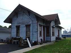 |
(#88002004) |
Beloit St. 42°37′41″N 89°15′22″W / 42.628056°N 89.256111°W |
Orfordville | |
| 90 | William J. Owen Store | Upload image | (#82000707) |
220 Depot St. 42°40′11″N 89°12′40″W / 42.669722°N 89.211111°W |
Footville | |
| 91 | J. L. Pangborn House |  |
(#85001664) |
300 Allen St. 42°33′20″N 88°51′47″W / 42.555556°N 88.863056°W |
Clinton | |
| 92 | Payne-Craig House | Upload image | (#87000990) |
2200 W. Memorial Dr. 42°41′44″N 89°02′52″W / 42.695556°N 89.047778°W |
Janesville | |
| 93 | Pearsons Hall of Science |  |
(#80000190) |
Beloit College campus 42°30′13″N 89°01′53″W / 42.503611°N 89.031389°W |
Beloit | |
| 94 | Pomeroy and Pelton Tobacco Warehouse | Upload image | (#98000848) |
1 W. Fulton St. 42°50′00″N 89°04′10″W / 42.833333°N 89.069444°W |
Edgerton | Also known as Dickinson Tobacco Warehouse |
| 95 | J. K. Porter Farmstead | Upload image | (#80000400) |
SR 1 42°50′09″N 89°13′35″W / 42.835833°N 89.226389°W |
Evansville | |
| 96 | Prospect Hill Historic District | Upload image | (#92001558) |
Roughly bounded by Eisenhower, Prospect and Atwood Aves., Milwaukee St., Parker Dr. and Centerway 42°41′10″N 89°01′16″W / 42.686111°N 89.021111°W |
Janesville | |
| 97 | Brewster Randall House | Upload image | (#84003782) |
1412 Ruger Ave. 42°41′10″N 89°00′19″W / 42.686111°N 89.005278°W |
Janesville | |
| 98 | Rasey House |  |
(#74000123) |
517 Prospect St. 42°30′05″N 89°01′50″W / 42.501389°N 89.030556°W |
Beloit | |
| 99 | Charles Rau House |  |
(#83003423) |
757 Euclid Ave. 42°30′01″N 89°02′56″W / 42.500278°N 89.048889°W |
Beloit | |
| 100 | Richardson Grout House | Upload image | (#80000402) |
SR 1 42°49′06″N 89°12′41″W / 42.818333°N 89.211389°W |
Evansville | |
| 101 | Hamilton Richardson House | Upload image | (#78000135) |
429 Prospect Ave. 42°41′14″N 89°01′13″W / 42.687222°N 89.020278°W |
Janesville | |
| 102 | Richardson-Brinkman Cobblestone House |  |
(#77000052) |
607 W. Milwaukee Rd. 42°33′27″N 88°51′58″W / 42.5575°N 88.866111°W |
Clinton | |
| 103 | Rindfleisch Building | 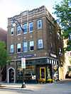 |
(#83003424) |
512 E. Grand Ave. 42°29′58″N 89°02′00″W / 42.499444°N 89.033333°W |
Beloit | |
| 104 | Risum Round Barn | Upload image | (#79000112) |
Southwest of Orfordville 42°35′55″N 89°17′35″W / 42.598611°N 89.293056°W |
Orfordville | |
| 105 | John C. and Mary Robinson Farmstead | Upload image | (#09001221) |
18002 W. County Trunk Highway C 42°47′14″N 89°21′26″W / 42.787339°N 89.357269°W |
Union | |
| 106 | St. John's Lutheran Church | Upload image | (#12000521) |
312 S. 3rd St. 42°46′34″N 89°18′21″W / 42.775992°N 89.305706°W |
Evansville | |
| 107 | Shopiere Congregational Church | Upload image | (#76000078) |
Buss Rd., near Shopiere Rd. 42°34′14″N 88°56′17″W / 42.570556°N 88.938056°W |
Shopiere | |
| 108 | Stephen Slaymaker House | 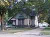 |
(#83003425) |
348 Euclid Ave. 42°29′59″N 89°02′32″W / 42.499722°N 89.042222°W |
Beloit | |
| 109 | Samuel Smiley House | Upload image | (#82001849) |
SE of Orfordville on WI 213 42°35′59″N 89°12′25″W / 42.599722°N 89.206944°W |
Orfordville | |
| 110 | John Smith House | 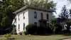 |
(#85001663) |
312 Pleasant St. 42°33′24″N 88°52′04″W / 42.556667°N 88.867778°W |
Clinton | |
| 111 | South First Street Residential Historic District | Upload image | (#11000532) |
341, 348, 349, 402, 408, 409, 412, 419, 433, 439 & 443, S. 1st St. 42°46′29″N 89°18′03″W / 42.774722°N 89.300833°W |
Evansville | NRHP # 11000532 |
| 112 | South Main Street Historic District | Upload image | (#90000820) |
Roughly S. Main St. from Milwaukee St. to Rock Co. Courthouse grounds and E. Court St. from Parker Dr. to Rock R. 42°40′55″N 89°01′17″W / 42.681944°N 89.021389°W |
Janesville | |
| 113 | St. Paul's Episcopal Church | 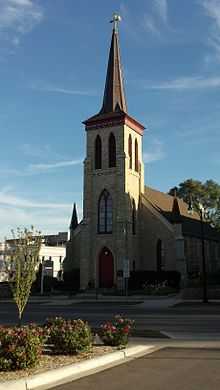 |
(#78000136) |
212 W. Grand Ave. 42°30′05″N 89°02′22″W / 42.501389°N 89.039444°W |
Beloit | |
| 114 | Stark-Clint House | Upload image | (#85002124) |
Creek Rd. 42°35′04″N 88°55′32″W / 42.584444°N 88.925556°W |
Tiffany | |
| 115 | Harrison Stebbins House | Upload image | (#80000401) |
SR 1 42°49′36″N 89°12′55″W / 42.826667°N 89.215278°W |
Evansville | |
| 116 | Soloman J. Strang House | Upload image | (#82000708) |
231 North Gilbert 42°40′25″N 89°12′32″W / 42.673611°N 89.208889°W |
Footville | |
| 117 | Strong Building |  |
(#83003426) |
400-408 E. Grand Ave. 42°29′58″N 89°02′07″W / 42.499444°N 89.035278°W |
Beloit | |
| 118 | Strong Partridge Mound Group | Upload image | (#94000057) |
1750 Arrowhead Dr. 42°31′09″N 89°00′37″W / 42.519167°N 89.010278°W |
Beloit | |
| 119 | John and Eleanor Strunk House | Upload image | (#08000184) |
2306 N. Parker Dr. 42°42′38″N 89°01′59″W / 42.710556°N 89.033056°W |
Janesville | |
| 120 | Tallman House | Upload image | (#70000085) |
440 N. Jackson St. 42°41′10″N 89°01′53″W / 42.686111°N 89.031389°W |
Janesville | |
| 121 | A. E. Taylor House |  |
(#85001662) |
318 Durand St. 42°33′25″N 88°51′51″W / 42.556944°N 88.864167°W |
Clinton | |
| 122 | Turtleville Iron Bridge | .jpg) |
(#77000053) |
N of Beloit on Lathers Rd. 42°33′56″N 88°57′52″W / 42.565556°N 88.964444°W |
Beloit | |
| 123 | West Luther Valley Lutheran Church | Upload image | (#80000191) |
SW of Orfordville on W. Church Rd. 42°36′26″N 89°19′35″W / 42.607222°N 89.326389°W |
Orfordville | |
| 124 | West Milwaukee Street Historic District | Upload image | (#90000790) |
Roughly bounded by Wall, River, Court, and Academy Sts. 42°40′52″N 89°01′33″W / 42.681111°N 89.025833°W |
Janesville | |
| 125 | Frances Willard Schoolhouse | Upload image | (#77000054) |
Craig Ave. 42°41′29″N 89°00′19″W / 42.691389°N 89.005278°W |
Janesville | |
| 126 | Wyman-Rye Farmstead |  |
(#77000055) |
N of Clinton on Wyman-Rye Dr. 42°35′28″N 88°52′18″W / 42.591111°N 88.871667°W |
Clinton | |
| 127 | Florence Yates House |  |
(#83003427) |
1614 Emerson St. 42°30′16″N 89°00′59″W / 42.504444°N 89.016389°W |
Beloit |
Formerly listed
| [2] | Name on the Register | Image | Date listed | Date removed | Location | City or town | Summary |
|---|---|---|---|---|---|---|---|
| 1 | Belle Cottage | Upload image | (#79000107) | 1837 Center Ave. |
Janesville | Gothic revival-styled house clad in local cobblestones, built by George Josiah Kellog in 1854. A.k.a. Damrow House. Demolished February 27, 1987.[5] | |
| 2 | Carlton Hotel | Upload image | (#88002173) | 14 N. Henry St. |
Edgerton | 3-story German Renaissance Revival hotel designed by Frank H. Kemp and built in 1898. Destroyed by fire in 1991.[6] | |
| 3 | Dean-Armstrong-Englund Octagonal Barn | Upload image | (#79003769) | |
Milton | Built in 1893.[7]:3 | |
| 4 | Dougan Round Barn | 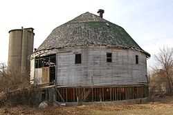 |
(#79000108) | 444 West Colley Rd. |
Beloit | Demolished in 2012.[8] | |
| 5 | J.B. Dow House and Carpenter Douglas Barn | Upload image | (#83003415) | 910 Board St. |
Beloit | The Dow house was a mix of Colonial Revival and Queen Anne styles, built in 1905. Dow was a realtor, lawyer and insurance salesman. Damaged by fire September 1996, demolished.[9] The 1847 barn is clad in cobblestone with limestone quoins.[10] | |
| 6 | Leedle Mill Truss Bridge | 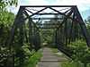 |
(#80000398) | SR 1 |
Evansville | ||
| 7 | Wisconsin School for the Blind-Music Building | Upload image | (#87000440) | 1700 W. State St. |
Janesville |
See also
| Wikimedia Commons has media related to National Register of Historic Places in Rock County, Wisconsin. |
- List of National Historic Landmarks in Wisconsin
- National Register of Historic Places listings in Wisconsin
References
- ↑ "National Register of Historic Places: Weekly List Actions". National Park Service, United States Department of the Interior. Retrieved on May 1, 2015.
- ↑ 2.0 2.1 Numbers represent an ordering by significant words. Various colorings, defined here, differentiate National Historic Landmarks and historic districts from other NRHP buildings, structures, sites or objects.
- ↑ "National Register Information System". National Register of Historic Places. National Park Service. 2008-04-24.
- ↑ The eight-digit number below each date is the number assigned to each location in the National Register Information System database, which can be viewed by clicking the number.
- ↑ "George Josiah Kellogg House (Belle Cottage)". Architecture and History Inventory. Wisconsin Historical Society. Retrieved 2014-09-02.
- ↑ "Carlton Hotel". Architecture and History Inventory. Wisconsin Historical Society. Retrieved 2014-09-02.
- ↑ Nancy Belle Douglas (November 10, 1978). "National Register of Historic Places Multiple Property Documentation: Centric Barns in Rock County TR" (PDF). National Park Service.
- ↑ http://www.beloitdailynews.com/news/historic-dougan-round-barn-demolished/article_92a45bf4-8a33-11e1-854c-001a4bcf887a.html
- ↑ "J. B. Dow House". Architecture and History Inventory. Wisconsin Historical Society. Retrieved 2014-09-02.
- ↑ "Carpenter-Douglas Barn". Architecture and History Inventory. Wisconsin Historical Society. Retrieved 2014-09-02.
External links
- Janesville's Benton Avenue Historic District: A Guide
- Janesville's Columbus Circle Historic District : A Guide
- Janesville's Court House Hill Historic District: A Guide
- Janesville's Look West Historic District: A Guide
- Main & Milwaukee, Janesville's Downtown Historic Districts: A Guide
- Janesville's Old Fourth Ward Historic District: A Guide
- Janesville's Prospect Hill & Conrad Cottages Historic Districts: A Guide
| ||||||||||||||||||||||||||
| |||||||||||||||||||||||||||||||||||||