National Register of Historic Places listings in Riverside County, California
This list includes properties and districts listed on the National Register of Historic Places in Riverside County, California. Click the "Map of all coordinates" link to the right to view a Google map of all properties and districts with latitude and longitude coordinates in the table below.[1]
-
- This National Park Service list is complete through NPS recent listings posted May 1, 2015.[2]
| [3] | Name on the Register[4] | Image | Date listed[5] | Location | City or town | Description |
|---|---|---|---|---|---|---|
| 1 | Administration Building, Sherman Institute | Upload image | (#80000831) |
9010 Magnolia Ave. 33°55′30″N 117°26′13″W / 33.925°N 117.436944°W |
Riverside | |
| 2 | All Souls Universalist Church | 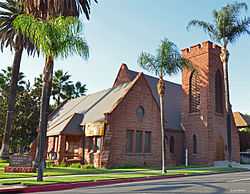 |
(#78000736) |
3657 Lemon St. 33°58′56″N 117°22′14″W / 33.982222°N 117.370556°W |
Riverside | |
| 3 | Andreas Canyon | Upload image | (#73000422) |
Address Restricted |
Palm Springs | |
| 4 | Archeological Sites CA-RIV-504 and CA-RIV-773 | Upload image | (#03000121) |
Address Restricted |
Blythe | |
| 5 | Arlington Branch Library and Fire Hall |  |
(#93000668) |
9556 Magnolia Ave. 33°55′11″N 117°26′48″W / 33.919722°N 117.446667°W |
Riverside | |
| 6 | Armory Hall |  |
(#91002032) |
252 N. Main St. 33°40′15″N 117°19′32″W / 33.670833°N 117.325556°W |
Lake Elsinore | |
| 7 | Barker Dam | 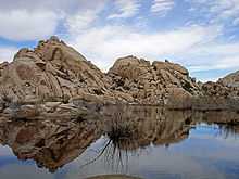 |
(#75000173) |
SE of Twentynine Palms in Joshua Tree National Park 34°01′52″N 116°08′39″W / 34.031111°N 116.144167°W |
Twentynine Palms | |
| 8 | Blythe Intaglios | .jpg) |
(#75000452) |
Address Restricted |
Blythe | |
| 9 | Buttercup Farms Pictograph | Upload image | (#76000509) |
Address Restricted |
Perris | |
| 10 | Cabot's Old Indian Pueblo Museum | 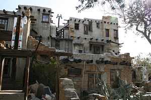 |
(#11000942) |
67-616 E. Desert View Ave. 33°57′29″N 116°28′56″W / 33.958069°N 116.482234°W |
Desert Hot Springs | |
| 11 | Andrew Carnegie Library | Upload image | (#77000324) |
8th and Main Sts. 33°52′23″N 117°33′56″W / 33.873056°N 117.565556°W |
Corona | Demolished in 1978 |
| 12 | William Childs House | Upload image | (#99000895) |
1151 Monte Vista Dr. 33°57′32″N 117°20′11″W / 33.958889°N 117.336389°W |
Riverside | |
| 13 | Chinatown | Upload image | (#90000151) |
Brockton and Tequesquite Aves. 33°58′35″N 117°23′05″W / 33.976389°N 117.384722°W |
Riverside | |
| 14 | Coachella Valley Fish Traps | Upload image | (#72000247) |
Restricted Address |
Valerie | |
| 15 | Corn Springs | Upload image | (#98001286) |
Address Restricted |
Desert Center | |
| 16 | Corona High School | Upload image | (#05000772) |
815 W. 6th St. 33°52′35″N 117°34′32″W / 33.876389°N 117.575617°W |
Corona | |
| 17 | Crescent Bathhouse | 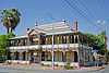 |
(#75000453) |
201 W. Graham Ave. 33°40′09″N 117°19′47″W / 33.669167°N 117.329722°W |
Lake Elsinore | |
| 18 | Desert Queen Mine | 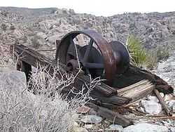 |
(#76000216) |
S of Twentynine Palms in Joshua Tree National Park 34°01′26″N 116°04′09″W / 34.023889°N 116.069167°W |
Twentynine Palms | |
| 19 | Estudillo Mansion | 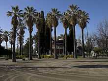 |
(#01001178) |
150 S. Dillon 33°46′51″N 116°58′02″W / 33.780833°N 116.967222°W |
San Jacinto | |
| 20 | Federal Post Office |  |
(#78000737) |
3720 Orange St. 33°58′55″N 117°22′18″W / 33.981944°N 117.371667°W |
Riverside | |
| 21 | First Church of Christ, Scientist |  |
(#92001250) |
3606 Lemon St. 33°58′57″N 117°22′11″W / 33.9825°N 117.369722°W |
Riverside | |
| 22 | First Congregational Church of Riverside |  |
(#97000297) |
3504 Mission Inn Ave. 33°58′54″N 117°22′16″W / 33.981667°N 117.371111°W |
Riverside | |
| 23 | Galleano Winery | Upload image | (#03000533) |
4231 Wineville Rd. 34°00′40″N 117°32′29″W / 34.011111°N 117.541389°W |
Mira Loma | |
| 24 | Rocco Garbani Homestead | Upload image | (#99001593) |
33555 Holland Rd. 33°39′34″N 117°04′24″W / 33.659444°N 117.073333°W |
Winchester | |
| 25 | Gilman Ranch |  |
(#76000508) |
1937 W. Gilman St. 33°56′15″N 116°53′54″W / 33.9375°N 116.898333°W |
Banning | |
| 26 | Grand Boulevard Historic District | 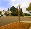 |
(#11000432) |
Grand Boulevard 33°52′09″N 117°34′02″W / 33.869167°N 117.567222°W |
Corona | |
| 27 | Harada House | 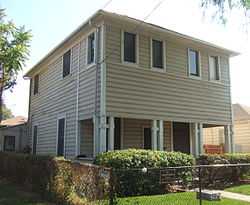 |
(#77000325) |
3356 Lemon St. 33°59′06″N 117°22′05″W / 33.985°N 117.368056°W |
Riverside | |
| 28 | Heritage House | 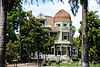 |
(#73000423) |
8193 Magnolia Ave. 33°56′05″N 117°25′20″W / 33.934722°N 117.422222°W |
Riverside | |
| 29 | Cornelius Jensen Ranch | Upload image | (#79000519) |
4350 Riverview Dr 33°59′34″N 117°25′01″W / 33.992778°N 117.416944°W |
Rubidoux | |
| 30 | Lake Norconian Club | 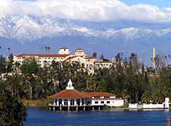 |
(#00000033) |
Junction of Fifth and Western Ave. 33°55′30″N 117°34′06″W / 33.925°N 117.568333°W |
Norco | |
| 31 | Gus Lederer Site | Upload image | (#03000118) |
Address Restricted |
Desert Center | |
| 32 | Luiseno Ancestral Origin Landscape | Upload image | (#14000851) |
Address restricted |
Temecula vicinity | |
| 33 | March Field Historic District | |
(#94001420) |
Eschscholtzia Ave., March Air Force Base 33°53′59″N 117°15′17″W / 33.899722°N 117.254722°W |
Riverside | |
| 34 | Martinez Canyon Rockhouse | 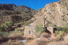 |
(#99001471) |
BLM, Palm Springs-South Coast Resource Area 33°30′20″N 116°19′31″W / 33.505556°N 116.325278°W |
North Palm Springs | |
| 35 | Martinez Historical District | Upload image | (#73000425) |
Off SR 86 33°33′46″N 116°09′12″W / 33.562778°N 116.153333°W |
Torres-Martinez Indian Reservation | |
| 36 | Masonic Temple | Upload image | (#80000832) |
3650 11th St. 33°58′43″N 117°22′30″W / 33.978611°N 117.375°W |
Riverside | |
| 37 | McCoy Spring Archeological Site | Upload image | (#82002226) |
Address Restricted |
Blythe | |
| 38 | Mission Court Bungalows | Upload image | (#93000549) |
3355-3373 Second St. and 3354-3362 First St. 33°59′12″N 117°21′55″W / 33.986667°N 117.365278°W |
Riverside | |
| 39 | Mission Inn | 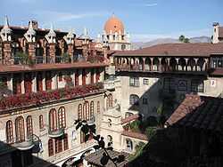 |
(#71000173) |
3649 7th St. 33°59′00″N 117°22′18″W / 33.983333°N 117.371667°W |
Riverside | |
| 40 | Mount San Jacinto State Park Historic District |  |
(#13000416) |
25905 CA 243 33°45′01″N 116°42′52″W / 33.750321°N 116.714344°W |
Idyllwild vicinity | |
| 41 | Murrieta Creek Archeological Area | Upload image | (#73000424) |
Address Restricted |
Temecula | |
| 42 | North Chuckwalla Mountain Quarry District | Upload image | (#81000165) |
Address Restricted |
Desert Center | |
| 43 | North Chuckwalla Mountains Petroglyph District Ca-Riv 1383 | Upload image | (#81000166) |
Address Restricted |
Desert Center | |
| 44 | Thomas O'Donnell House | Upload image | (#10001123) |
447 Alejo Rd. 33°49′49″N 116°33′09″W / 33.830278°N 116.5525°W |
Palm Springs | |
| 45 | Old YWCA Building | 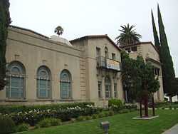 |
(#82002227) |
3425 Mission Inn Avenue 33°58′54″N 117°22′14″W / 33.981722°N 117.370472°W |
Riverside | |
| 46 | Perris Depot | 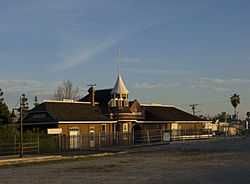 |
(#94000819) |
120 W. Fourth St. 33°46′58″N 117°13′46″W / 33.782639°N 117.229314°W |
Perris | |
| 47 | Riverside Municipal Auditorium and Soldiers' Memorial Building | 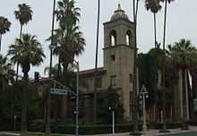 |
(#78000738) |
3485 7th St. 33°58′55″N 117°22′12″W / 33.981944°N 117.37°W |
Riverside | |
| 48 | Riverside-Arlington Heights Fruit Exchange | Upload image | (#80000833) |
3391 7th St. 33°58′52″N 117°22′10″W / 33.981111°N 117.369444°W |
Riverside | |
| 49 | Ryan House and Lost Horse Well | 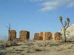 |
(#75000175) |
S of Twentynine Palms in Joshua Tree National Park 33°59′06″N 116°08′52″W / 33.985°N 116.147778°W |
Twentynine Palms | |
| 50 | San Pedro, Los Angeles, & Salt Lake RR Depot | 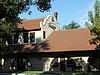 |
(#77000326) |
3751 Vine St. 33°58′45″N 117°21′59″W / 33.979167°N 117.366389°W |
Riverside | |
| 51 | San Timoteo Canyon Schoolhouse |  |
(#00001646) |
31985 San Timoteo Canyon Rd. 33°58′33″N 117°06′10″W / 33.975833°N 117.102778°W |
Redlands | |
| 52 | M. H. Simon's Undertaking Chapel |  |
(#80000834) |
3610 11th St. 33°58′43″N 117°22′29″W / 33.978611°N 117.374722°W |
Riverside | |
| 53 | Southern Hotel | 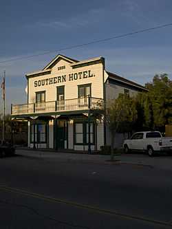 |
(#92001384) |
445 S. D St. 33°46′55″N 117°13′42″W / 33.781833°N 117.228417°W |
Perris | |
| 54 | Steel Development House Number 2 | Upload image | (#12000125) |
3125 N. Sunny View Dr. 33°51′30″N 116°32′40″W / 33.858228°N 116.544324°W |
Riverside | |
| 55 | Sutherland Fruit Company | Upload image | (#86000732) |
3191 Seventh St. 33°58′50″N 117°21′59″W / 33.980556°N 117.366389°W |
Riverside | |
| 56 | Tahquitz Canyon |  |
(#72000246) |
500 West Mesquite 33°48′31″N 116°33′02″W / 33.808592°N 116.550491°W |
Palm Springs | |
| 57 | University Heights Junior High School | Upload image | (#93000547) |
2060 University Ave. 33°58′30″N 117°21′20″W / 33.975°N 117.355556°W |
Riverside | |
| 58 | Victoria Avenue | 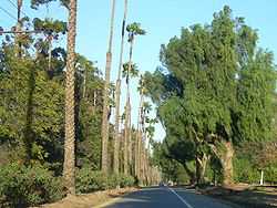 |
(#00001267) |
Victoria Ave., from Arlington Ave. to Boundary Ln. 33°55′33″N 117°23′57″W / 33.925833°N 117.399167°W |
Riverside | |
| 59 | Woman's Improvement Club Clubhouse | 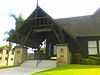 |
(#88002014) |
1101 S. Main St. 33°52′12″N 117°33′58″W / 33.87°N 117.566111°W |
Corona |
See also
- National Register of Historic Places listings in California
- List of National Historic Landmarks in California
- California Historical Landmarks in Riverside County, California
References
- ↑ The latitude and longitude information provided in this table was derived originally from the National Register Information System, which has been found to be fairly accurate for about 99% of listings. For about 1% of NRIS original coordinates, experience has shown that one or both coordinates are typos or otherwise extremely far off; some corrections may have been made. A more subtle problem causes many locations to be off by up to 150 yards, depending on location in the country: most NRIS coordinates were derived from tracing out latitude and longitudes off of USGS topographical quadrant maps created under the North American Datum of 1927, which differs from the current, highly accurate WGS84 GPS system used by most on-line maps. Chicago is about right, but NRIS longitudes in Washington are higher by about 4.5 seconds, and are lower by about 2.0 seconds in Maine. Latitudes differ by about 1.0 second in Florida. Some locations in this table may have been corrected to current GPS standards.
- ↑ "National Register of Historic Places: Weekly List Actions". National Park Service, United States Department of the Interior. Retrieved on May 1, 2015.
- ↑ Numbers represent an ordering by significant words. Various colorings, defined here, differentiate National Historic Landmarks and historic districts from other NRHP buildings, structures, sites or objects.
- ↑ "National Register Information System". National Register of Historic Places. National Park Service. 2008-04-24.
- ↑ The eight-digit number below each date is the number assigned to each location in the National Register Information System database, which can be viewed by clicking the number.
| Wikimedia Commons has media related to National Register of Historic Places in Riverside County, California. |
External links
- NoeHill Travels in California: Historic Sites in Riverside County for a listing of NRHP and California landmarks
| ||||||||||||||||||||||||||