National Register of Historic Places listings in Rio Grande County, Colorado

Location of Rio Grande County in Colorado
This is a list of the National Register of Historic Places listings in Rio Grande County, Colorado. It is intended to be a complete list of the properties and districts on the National Register of Historic Places in Rio Grande County, Colorado, United States. The locations of National Register properties and districts for which the latitude and longitude coordinates are included below, may be seen in a Google map.[1]
There are 13 properties and districts listed on the National Register in the county.
- This National Park Service list is complete through NPS recent listings posted May 1, 2015.[2]
Listings county-wide
| [3] | Name on the Register[4] | Image | Date listed[5] | Location | City or town | Description |
|---|---|---|---|---|---|---|
| 1 | Carnegie Library | .JPG) |
(#95000439) |
120 Jefferson St. 37°34′48″N 106°08′40″W / 37.58°N 106.144444°W |
Monte Vista | |
| 2 | Central School Auditorium and Gymnasium | 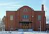 |
(#96000274) |
612 1st Ave. 37°34′46″N 106°08′59″W / 37.579444°N 106.149722°W |
Monte Vista | |
| 3 | Creede Branch, Denver and Rio Grande Railroad | Upload image | (#02001408) |
Along the D&RGW right-of-way between South Fork and Creede 37°44′46″N 106°22′13″W / 37.746111°N 106.370278°W |
South Fork | |
| 4 | Denver & Rio Grande Railroad South Fork Water Tank | 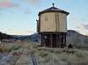 |
(#02001132) |
U.S. Route 160 37°40′18″N 106°37′31″W / 37.671667°N 106.625278°W |
South Fork | |
| 5 | El Monte Hotel | 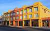 |
(#90000870) |
925 1st Ave. 37°34′50″N 106°08′43″W / 37.580556°N 106.145278°W |
Monte Vista | |
| 6 | First Methodist Episcopal Church | .JPG) |
(#03001011) |
215 Washington St. 37°34′44″N 106°08′52″W / 37.578889°N 106.147778°W |
Monte Vista | |
| 7 | Keck Homestead | Upload image | (#98000437) |
12888 County Road 15 37°42′00″N 106°26′03″W / 37.7°N 106.434167°W |
Del Norte | |
| 8 | Monte Vista Downtown Historic District | 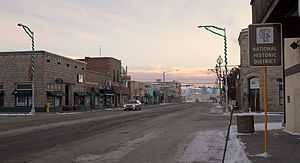 |
(#91001612) |
Junction of 1st Ave. and Washington St. 37°34′50″N 106°08′51″W / 37.580556°N 106.1475°W |
Monte Vista | |
| 9 | Monte Vista Library | 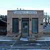 |
(#95000782) |
110 Jefferson St. 37°34′48″N 106°08′40″W / 37.58°N 106.144444°W |
Monte Vista | |
| 10 | Spruce Lodge | 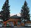 |
(#08001009) |
29431 U.S. Route 160 Coordinates missing |
South Fork | |
| 11 | Sutherland Bridge | 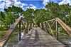 |
(#85000234) |
Off U.S. Route 160 37°40′35″N 106°19′36″W / 37.676389°N 106.326667°W |
Del Norte | Warren Pony Truss |
| 12 | US Post Office and Federal Building-Monte Vista Main | 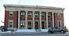 |
(#86000182) |
Washington and 2nd Ave. 37°34′45″N 106°08′39″W / 37.579167°N 106.144167°W |
Monte Vista | |
| 13 | Wheeler Bridge | 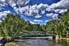 |
(#85000235) |
Off U.S. Route 160 37°39′29″N 106°17′20″W / 37.658056°N 106.288889°W |
Del Norte | Howe Pony Truss |
Former listings
| [3] | Name on the Register | Image | Date listed | Date removed | Location | City or town | Summary |
|---|---|---|---|---|---|---|---|
| 1 | Masonic Park Bridge | Upload image | (#85000236) | Masonic Park Drive over Rio Grande Coordinates missing |
South Fork vicinity | Replaced in 1994. |
See also
| Wikimedia Commons has media related to National Register of Historic Places in Rio Grande County, Colorado. |
- List of National Historic Landmarks in Colorado
- National Register of Historic Places listings in Colorado
References
- ↑ The latitude and longitude information provided in this table was derived originally from the National Register Information System, which has been found to be fairly accurate for about 99% of listings. For about 1% of NRIS original coordinates, experience has shown that one or both coordinates are typos or otherwise extremely far off; some corrections may have been made. A more subtle problem causes many locations to be off by up to 150 yards, depending on location in the country: most NRIS coordinates were derived from tracing out latitude and longitudes off of USGS topographical quadrant maps created under the North American Datum of 1927, which differs from the current, highly accurate WGS84 GPS system used by most on-line maps. Chicago is about right, but NRIS longitudes in Washington are higher by about 4.5 seconds, and are lower by about 2.0 seconds in Maine. Latitudes differ by about 1.0 second in Florida. Some locations in this table may have been corrected to current GPS standards.
- ↑ "National Register of Historic Places: Weekly List Actions". National Park Service, United States Department of the Interior. Retrieved on May 1, 2015.
- ↑ 3.0 3.1 Numbers represent an ordering by significant words. Various colorings, defined here, differentiate National Historic Landmarks and historic districts from other NRHP buildings, structures, sites or objects.
- ↑ "National Register Information System". National Register of Historic Places. National Park Service. 2008-04-24.
- ↑ The eight-digit number below each date is the number assigned to each location in the National Register Information System database, which can be viewed by clicking the number.
| ||||||||||||||||||||||||||
| |||||||||||||||||||||||||||||