National Register of Historic Places listings in Ridgewood, New Jersey

Map of Bergen County, New Jersey, highlighting Ridgewood
The table below includes 13 sites listed on the National Register of Historic Places in the village of Ridgewood, New Jersey in Bergen County. Latitude and longitude coordinates of the sites listed on this page may be displayed in a map or exported in several formats by clicking on one of the links in the box below the map to the right.[1]
National Register listings elsewhere in Bergen County may be found in separate articles.
- This National Park Service list is complete through NPS recent listings posted May 1, 2015.[2]
Current listings
| [3] |
Name on the Register[4] |
Image |
Date listed[5] |
Location |
Description |
|---|
| 1 |
Ackerman House |
Upload image |
01983-01-10-0000January 10, 1983
(#83001450) |
222 Doremus Ave.
40°58′23″N 74°07′37″W / 40.973056°N 74.126944°W / 40.973056; -74.126944 (Ackerman House) |
|
| 2 |
Ackerman House |
Upload image |
01983-01-10-0000January 10, 1983
(#83001451) |
252 Lincoln Ave.
40°58′29″N 74°08′05″W / 40.974722°N 74.134722°W / 40.974722; -74.134722 (Ackerman House) |
|
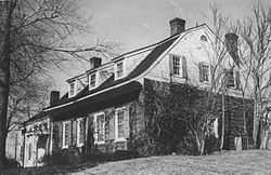
| 3 |
David Ackerman House |
|
01983-01-10-0000January 10, 1983
(#83001448) |
415 E. Saddle River
40°59′06″N 74°05′20″W / 40.985°N 74.088889°W / 40.985; -74.088889 (David Ackerman House) |
|
| 4 |
Ackerman-Van Emburgh House |
Upload image |
01983-01-10-0000January 10, 1983
(#83001456) |
789 E. Glen Ave.
40°59′03″N 74°05′19″W / 40.984167°N 74.088611°W / 40.984167; -74.088611 (Ackerman-Van Emburgh House) |
|
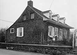
| 5 |
Archibald-Vroom House |
Upload image |
01984-07-24-0000July 24, 1984
(#84002596) |
160 E. Ridgewood Ave.
40°58′43″N 74°06′58″W / 40.978611°N 74.116111°W / 40.978611; -74.116111 (Archibald-Vroom House) |
|
| 6 |
Beech Street School |
Upload image |
01998-03-12-0000March 12, 1998
(#98000233) |
49 Cottage Place
40°58′47″N 74°06′53″W / 40.979647°N 74.114825°W / 40.979647; -74.114825 (Beech Street School) |
|
| 7 |
Paramus Reformed Church Historic District |
Upload image |
01975-02-25-0000February 25, 1975
(#75001121) |
Bounded by Franklin Tpke., NJ 17, Saddle River, S side of cemetery, and Glen Ave.
40°59′09″N 74°05′39″W / 40.985939°N 74.094078°W / 40.985939; -74.094078 (Paramus Reformed Church Historic District) |
|
| 8 |
Rathbone-Zabriskie House |
Upload image |
01983-01-10-0000January 10, 1983
(#83001545) |
570 N. Maple Ave.
40°59′43″N 74°06′41″W / 40.995278°N 74.111389°W / 40.995278; -74.111389 (Rathbone-Zabriskie House) |
|
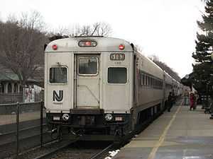
| 9 |
Ridgewood Station |
|
01984-06-22-0000June 22, 1984
(#84002582) |
Garber Sq.
40°58′51″N 74°07′16″W / 40.980833°N 74.121111°W / 40.980833; -74.121111 (Ridgewood Station) |
|
| 10 |
Van Dien House |
Upload image |
01983-01-10-0000January 10, 1983
(#83001567) |
627 Grove St.
40°57′59″N 74°06′03″W / 40.966389°N 74.100833°W / 40.966389; -74.100833 (Van Dien House) |
|
| 11 |
Vanderbeck House |
Upload image |
01983-01-10-0000January 10, 1983
(#83001564) |
249 Prospect St.
40°58′25″N 74°07′01″W / 40.973611°N 74.116944°W / 40.973611; -74.116944 (Vanderbeck House) |
|
| 12 |
Westervelt-Cameron House |
Upload image |
01983-01-10-0000January 10, 1983
(#83001581) |
26 E. Glen Ave.
40°59′21″N 74°06′54″W / 40.989167°N 74.115°W / 40.989167; -74.115 (Westervelt-Cameron House) |
|
| 13 |
Albert J. Zabriskie Farmhouse |
|
01977-11-07-0000November 7, 1977
(#77000847) |
7 E. Ridgewood Ave., Paramus, NJ (not Ridgewood, NJ)
40°58′12″N 74°04′39″W / 40.97°N 74.0775°W / 40.97; -74.0775 (Albert J. Zabriskie Farmhouse) |
|
References
- ↑ The latitude and longitude information provided in this table was derived originally from the National Register Information System, which has been found to be fairly accurate for about 99% of listings. For about 1% of NRIS original coordinates, experience has shown that one or both coordinates are typos or otherwise extremely far off; some corrections may have been made. A more subtle problem causes many locations to be off by up to 150 yards, depending on location in the country: most NRIS coordinates were derived from tracing out latitude and longitudes off of USGS topographical quadrant maps created under the North American Datum of 1927, which differs from the current, highly accurate WGS84 GPS system used by most on-line maps. Chicago is about right, but NRIS longitudes in Washington are higher by about 4.5 seconds, and are lower by about 2.0 seconds in Maine. Latitudes differ by about 1.0 second in Florida. Some locations in this table may have been corrected to current GPS standards.
- ↑ "National Register of Historic Places: Weekly List Actions". National Park Service, United States Department of the Interior. Retrieved on May 1, 2015.
- ↑ Numbers represent an ordering by significant words. Various colorings, defined here, differentiate National Historic Landmarks and historic districts from other NRHP buildings, structures, sites or objects.
- ↑ "National Register Information System". National Register of Historic Places. National Park Service. 2010-07-09.
- ↑ The eight-digit number below each date is the number assigned to each location in the National Register Information System database, which can be viewed by clicking the number.
|
|---|
| | Topics | |
|---|
| | Lists by states | |
|---|
| | Lists by insular areas | |
|---|
| | Lists by associated states | |
|---|
| | Other areas | |
|---|
|
-
 Category Category
-
 Portal Portal
-
 WikiProject WikiProject
|
|