National Register of Historic Places listings in Republic County, Kansas
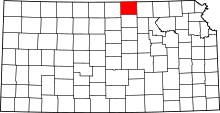
Location of Republic County in Kansas
This is a list of the National Register of Historic Places listings in Republic County, Kansas.
This is intended to be a complete list of the properties and districts on the National Register of Historic Places in Republic County, Kansas, United States. The locations of National Register properties and districts for which the latitude and longitude coordinates are included below, may be seen in a Google map.[1]
There are 12 properties and districts listed on the National Register in the county.
- This National Park Service list is complete through NPS recent listings posted April 24, 2015.[2]
Current listings
| [3] | Name on the Register[4] | Image | Date listed[5] | Location | City or town | Description |
|---|---|---|---|---|---|---|
| 1 | Belleville High School | 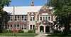 |
(#13000434) |
915 W.18th Street 39°49′28″N 97°38′02″W / 39.82433°N 97.63398°W |
Belleville | |
| 2 | Cossaart Barn | Upload image | (#09001166) |
3040 Birch Rd. 39°59′14″N 97°22′50″W / 39.987222°N 97.380556°W |
Narka | |
| 3 | County Line Bowstring | 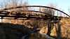 |
(#89002192) |
Over West Creek, northwest of Hollis 39°39′12″N 97°34′21″W / 39.653333°N 97.5725°W |
Wayne | |
| 4 | Cuba Blacksmith Shop | |
(#09000810) |
½ block west of Baird St. on Lynn St. 39°48′02″N 97°27′31″W / 39.800572°N 97.458699°W |
Cuba | |
| 5 | East Riley Creek Bridge | 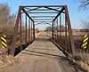 |
(#89002176) |
Over East Riley Creek, S of Belleville Coordinates missing |
Belleville | |
| 6 | Pawnee Indian Village Site | |
(#71000325) |
On K-266 and the Republican River 39°54′30″N 97°51′38″W / 39.908333°N 97.860556°W |
Republic | |
| 7 | Republic County Courthouse | 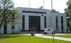 |
(#02000393) |
Bounded by M St., 18th St., N St., and 19th St. 39°49′05″N 97°37′24″W / 39.818056°N 97.623333°W |
Belleville | |
| 8 | Riley Creek Bridge | 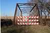 |
(#89002175) |
Over Riley Creek, south of Belleville 39°47′16″N 97°37′56″W / 39.787778°N 97.632222°W |
Belleville | |
| 9 | Shimanek Barn | 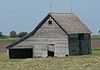 |
(#09000194) |
1806 220 Road 39°54′03″N 97°32′20″W / 39.900889°N 97.538936°W |
Munden | Agriculture-Related Resources of Kansas MPS |
| 10 | Site No. JF00-072 | 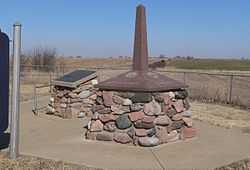 |
(#87001000) |
Junction of Thayer, Jefferson, Washington, and Republic County lines 40°00′07″N 97°22′09″W / 40.00198°N 97.3692°W |
Mahaska | |
| 11 | S.T. Stevenson House | 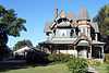 |
(#10000451) |
2012 N St. 39°49′18″N 97°37′45″W / 39.821667°N 97.629167°W |
Belleville | |
| 12 | US Post Office-Belleville | 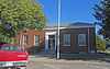 |
(#89001633) |
1119 18th St. 39°49′28″N 97°37′57″W / 39.824444°N 97.6325°W |
Belleville |
See also
| Wikimedia Commons has media related to National Register of Historic Places in Republic County, Kansas. |
- List of National Historic Landmarks in Kansas
- National Register of Historic Places listings in Kansas
References
- ↑ The latitude and longitude information provided in this table was derived originally from the National Register Information System, which has been found to be fairly accurate for about 99% of listings. For about 1% of NRIS original coordinates, experience has shown that one or both coordinates are typos or otherwise extremely far off; some corrections may have been made. A more subtle problem causes many locations to be off by up to 150 yards, depending on location in the country: most NRIS coordinates were derived from tracing out latitude and longitudes off of USGS topographical quadrant maps created under the North American Datum of 1927, which differs from the current, highly accurate WGS84 GPS system used by most on-line maps. Chicago is about right, but NRIS longitudes in Washington are higher by about 4.5 seconds, and are lower by about 2.0 seconds in Maine. Latitudes differ by about 1.0 second in Florida. Some locations in this table may have been corrected to current GPS standards.
- ↑ "National Register of Historic Places: Weekly List Actions". National Park Service, United States Department of the Interior. Retrieved on April 24, 2015.
- ↑ Numbers represent an ordering by significant words. Various colorings, defined here, differentiate National Historic Landmarks and historic districts from other NRHP buildings, structures, sites or objects.
- ↑ "National Register Information System". National Register of Historic Places. National Park Service. 2009-03-13.
- ↑ The eight-digit number below each date is the number assigned to each location in the National Register Information System database, which can be viewed by clicking the number.


| |||||||||||||||||||||