National Register of Historic Places listings in Putnam County, Florida
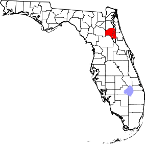
Location of Putnam County in Florida
This is a list of the National Register of Historic Places listings in Putnam County, Florida.
This is intended to be a complete list of the properties and districts on the National Register of Historic Places in Putnam County, Florida, United States. The locations of National Register properties and districts for which the latitude and longitude coordinates are included below may be seen in a Google map.[1]
There are 17 properties and districts listed on the National Register in the county.
- This National Park Service list is complete through NPS recent listings posted May 1, 2015.[2]
Current listings
| [3] |
Name on the Register[4] |
Image |
Date listed[5] |
Location |
City or town |
Description |
|---|
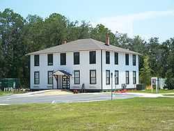
| 1 |
Bostwick School |
|
01999-09-29-0000September 29, 1999
(#99001204) |
125 Tillman Street
29°46′16″N 81°38′02″W / 29.771111°N 81.633889°W / 29.771111; -81.633889 (Bostwick School) |
Bostwick |
|
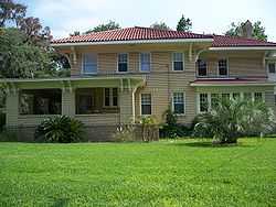
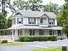
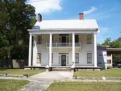
| 2 |
Bronson-Mulholland House |
|
01972-12-27-0000December 27, 1972
(#72000351) |
Madison between 1st and 2nd Streets
29°39′00″N 81°37′42″W / 29.65°N 81.628333°W / 29.65; -81.628333 (Bronson-Mulholland House) |
Palatka |
|
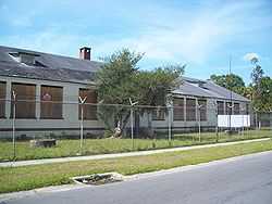
| 3 |
Central Academy |
|
01998-11-12-0000November 12, 1998
(#98001348) |
1207 Washington Street
29°39′19″N 81°38′26″W / 29.655278°N 81.640556°W / 29.655278; -81.640556 (Central Academy) |
Palatka |
|
| 4 |
Crescent City Historic District |
|
01996-12-05-0000December 5, 1996
(#96001367) |
Roughly bounded by Lake Stella, Vernon Avenue, Lake Crescent, and Orange Avenue
29°25′49″N 81°30′36″W / 29.430278°N 81.51°W / 29.430278; -81.51 (Crescent City Historic District) |
Crescent City |
|
| 5 |
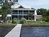
Cummings House |
Upload image |
02015-03-17-0000March 17, 2015
(#15000075) |
298 Cty. Rd. 310
29°32′32″N 81°46′28″W / 29.542115°N 81.774488°W / 29.542115; -81.774488 (Cummings House) |
Palatka vicinity |
|
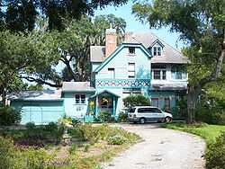
| 6 |
Hubbard House |
|
01973-08-14-0000August 14, 1973
(#73000601) |
600 North Park Street in Hubbard Park
29°26′02″N 81°30′22″W / 29.433889°N 81.506111°W / 29.433889; -81.506111 (Hubbard House) |
Crescent City |
|
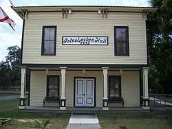
| 7 |
Interlachen Hall |
|
02000-06-02-0000June 2, 2000
(#00000561) |
215 Atlantic Avenue
29°37′24″N 81°53′32″W / 29.623333°N 81.892222°W / 29.623333; -81.892222 (Interlachen Hall) |
Interlachen |
|
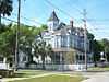
| 8 |
Larimer Memorial Library |
|
02008-03-12-0000March 12, 2008
(#08000163) |
216 Reid Street
29°38′51″N 81°37′50″W / 29.6475°N 81.630556°W / 29.6475; -81.630556 (Larimer Memorial Library) |
Palatka |
|
| 9 |
Melrose Historic District |
|
01990-01-12-0000January 12, 1990
(#89002305) |
Roughly bounded by Seminole Ridge Road, Grove Street, South Street, Quail Street, and Melrose Bay
29°42′45″N 82°03′03″W / 29.7125°N 82.050833°W / 29.7125; -82.050833 (Melrose Historic District) |
Melrose |
|
| 10 |
Melrose Woman's Club |
|
01978-04-06-0000April 6, 1978
(#78000956) |
Pine Street
29°42′40″N 82°02′49″W / 29.711111°N 82.046944°W / 29.711111; -82.046944 (Melrose Woman's Club) |
Melrose |
|
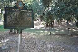
| 11 |
Mount Royal |
|
01973-05-07-0000May 7, 1973
(#73000603) |
Address Restricted
29°26′11″N 81°39′37″W / 29.436389°N 81.660278°W / 29.436389; -81.660278 (Mount Royal) |
Welaka |
|
| 12 |
Old A.C.L. Union Depot |
|
01988-02-25-0000February 25, 1988
(#88000162) |
200 North Twelfth Street
29°38′58″N 81°38′26″W / 29.649444°N 81.640556°W / 29.649444; -81.640556 (Old A.C.L. Union Depot) |
Palatka |
|
| 13 |
Palatka North Historic District |
|
01983-11-17-0000November 17, 1983
(#83003552) |
Roughly bounded by the St. Johns River and Bronson, North 1st, North 5th, and Main Streets
29°38′59″N 81°37′47″W / 29.649722°N 81.629722°W / 29.649722; -81.629722 (Palatka North Historic District) |
Palatka |
|
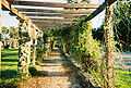
| 14 |
Palatka Ravine Gardens Historic District |
|
01999-06-10-0000June 10, 1999
(#99000694) |
1600 Twigg Street
29°38′00″N 81°38′48″W / 29.633333°N 81.646667°W / 29.633333; -81.646667 (Palatka Ravine Gardens Historic District) |
Palatka |
|
| 15 |
Palatka South Historic District |
|
01983-11-17-0000November 17, 1983
(#83003553) |
Roughly bounded by the St. Johns River and Oak, South 9th, and Morris Streets
29°38′40″N 81°38′06″W / 29.644444°N 81.635°W / 29.644444; -81.635 (Palatka South Historic District) |
Palatka |
|
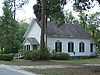
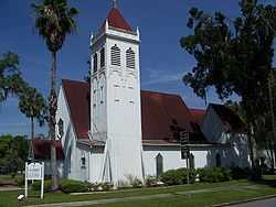
| 16 |
St. Marks Episcopal Church |
|
01973-05-09-0000May 9, 1973
(#73000602) |
2nd and Main Streets
29°38′55″N 81°37′46″W / 29.648611°N 81.629444°W / 29.648611; -81.629444 (St. Marks Episcopal Church) |
Palatka |
|
| 17 |
Tenney House and Groveland Hotel |
|
01997-10-30-0000October 30, 1997
(#97001284) |
100 and 102 Commercial Avenue
29°44′48″N 81°32′50″W / 29.746667°N 81.547222°W / 29.746667; -81.547222 (Tenney House and Groveland Hotel) |
Federal Point |
|
See also
References
- ↑ The latitude and longitude information provided in this table was derived originally from the National Register Information System, which has been found to be fairly accurate for about 99% of listings. For about 1% of NRIS original coordinates, experience has shown that one or both coordinates are typos or otherwise extremely far off; some corrections may have been made. A more subtle problem causes many locations to be off by up to 150 yards, depending on location in the country: most NRIS coordinates were derived from tracing out latitude and longitudes off of USGS topographical quadrant maps created under the North American Datum of 1927, which differs from the current, highly accurate WGS84 GPS system used by most on-line maps. Chicago is about right, but NRIS longitudes in Washington are higher by about 4.5 seconds, and are lower by about 2.0 seconds in Maine. Latitudes differ by about 1.0 second in Florida. Some locations in this table may have been corrected to current GPS standards.
- ↑ "National Register of Historic Places: Weekly List Actions". National Park Service, United States Department of the Interior. Retrieved on May 1, 2015.
- ↑ Numbers represent an ordering by significant words. Various colorings, defined here, differentiate National Historic Landmarks and historic districts from other NRHP buildings, structures, sites or objects.
- ↑ "National Register Information System". National Register of Historic Places. National Park Service. 2009-03-13.
- ↑ The eight-digit number below each date is the number assigned to each location in the National Register Information System database, which can be viewed by clicking the number.
|
|---|
| | Lists by county | | |
|---|
| | Lists by city | |
|---|
| | Other lists | |
|---|
| |
|