| [3] |
Name on the Register[4] |
Image |
Date listed[5] |
Location |
City or town |
Description |
|---|
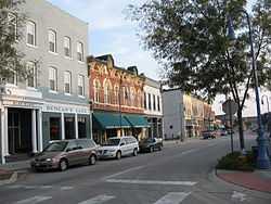
| 1 |
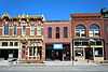
100 Block of West Broadway Historic District |
|
02002-05-09-0000May 9, 2002
(#02000455) |
W. Broadway, 1st St., and 4th St.
41°15′46″N 95°50′42″W / 41.262778°N 95.845°W / 41.262778; -95.845 (100 Block of West Broadway Historic District) |
Council Bluffs |
|
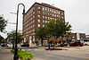
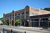
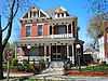
| 2 |
Bennett Building |
|
02001-08-08-0000August 8, 2001
(#01000861) |
405 West Broadway
41°15′38″N 95°50′57″W / 41.260556°N 95.849167°W / 41.260556; -95.849167 (Bennett Building) |
Council Bluffs |
|
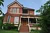
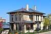
| 3 |
August Beresheim House |
|
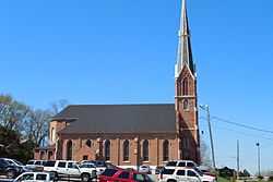
01976-08-13-0000August 13, 1976
(#76000802) |
621 3rd St.
41°15′16″N 95°50′52″W / 41.254444°N 95.847778°W / 41.254444; -95.847778 (August Beresheim House) |
Council Bluffs |
|
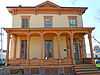
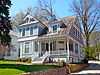
| 4 |
Jean and Inez Bregant House |
|
02013-10-16-0000October 16, 2013
(#13000832) |
514 S. 4th Street
41°15′23″N 95°51′01″W / 41.256442°N 95.850175°W / 41.256442; -95.850175 (Jean and Inez Bregant House) |
Council Bluffs |
|
| 5 |
Carstens Farmstead |
Upload image |
01979-07-10-0000July 10, 1979
(#79000932) |
South of Shelby on Iowa Highway 168
41°28′57″N 95°27′22″W / 41.4825°N 95.456111°W / 41.4825; -95.456111 (Carstens Farmstead) |
Shelby |
|
| 6 |
Thomas E. Cavin House |
|
01984-09-27-0000September 27, 1984
(#84001306) |
150 Park Ave.
41°15′36″N 95°50′39″W / 41.26°N 95.844167°W / 41.26; -95.844167 (Thomas E. Cavin House) |
Council Bluffs |
|
| 7 |
Chevra B'nai Yisroel Synagogue |
|
02007-03-07-0000March 7, 2007
(#07000113) |
618 Mynster St.
41°15′52″N 95°51′09″W / 41.264444°N 95.8525°W / 41.264444; -95.8525 (Chevra B'nai Yisroel Synagogue) |
Council Bluffs |
|
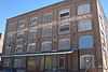
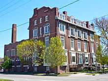
| 8 |
Chicago, Rock Island & Pacific Railroad Passenger Depot |
|
01995-07-21-0000July 21, 1995
(#95000856) |
1512 S. Main St.
41°14′49″N 95°51′08″W / 41.246944°N 95.852222°W / 41.246944; -95.852222 (Chicago, Rock Island & Pacific Railroad Passenger Depot) |
Council Bluffs |
|
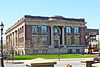
| 9 |
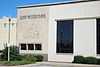
Council Bluffs Free Public Library |
|
01999-01-27-0000January 27, 1999
(#99000048) |
200 Pearl St.
41°15′29″N 95°51′04″W / 41.258056°N 95.851111°W / 41.258056; -95.851111 (Council Bluffs Free Public Library) |
Council Bluffs |
|
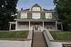
| 10 |
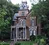
Grenville M. Dodge House |
|
01966-10-15-0000October 15, 1966
(#66000338) |
605 S. 3rd St.
41°15′17″N 95°50′50″W / 41.254722°N 95.847222°W / 41.254722; -95.847222 (Grenville M. Dodge House) |
Council Bluffs |
|
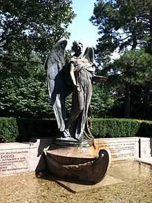
| 11 |
Ruth Anne Dodge Memorial |
|
01980-02-08-0000February 8, 1980
(#80001457) |
Fairview Cemetery
41°16′02″N 95°50′51″W / 41.267222°N 95.8475°W / 41.267222; -95.8475 (Ruth Anne Dodge Memorial) |
Council Bluffs |
|
| 12 |
Eckle Round Barn |
Upload image |
01986-06-30-0000June 30, 1986
(#86001470) |
Off Iowa Highway 168
41°30′20″N 95°29′37″W / 41.505556°N 95.493611°W / 41.505556; -95.493611 (Eckle Round Barn) |
Shelby |
part of the Iowa Round Barns: The Sixty Year Experiment Thematic Resource (TR)
|
| 13 |
German Bank Building of Walnut, Iowa |
Upload image |
01991-05-01-0000May 1, 1991
(#91000536) |
Junction of Highland and Central Sts.
41°28′39″N 95°13′20″W / 41.4775°N 95.222222°W / 41.4775; -95.222222 (German Bank Building of Walnut, Iowa) |
Walnut |
|
| 14 |
Graceland Cemetery Chapel |
Upload image |
01986-04-28-0000April 28, 1986
(#86000873) |
Graceland Cemetery, U.S. Route 59
41°29′32″N 95°20′15″W / 41.492222°N 95.3375°W / 41.492222; -95.3375 (Graceland Cemetery Chapel) |
Avoca |
|
| 15 |
Hancock Savings Bank |
Upload image |
01983-01-19-0000January 19, 1983
(#83000401) |
311 Main St.
41°23′27″N 95°21′43″W / 41.390833°N 95.361944°W / 41.390833; -95.361944 (Hancock Savings Bank) |
Hancock |
|
| 16 |
Haymarket Commercial Historic District |
|
01985-04-11-0000April 11, 1985
(#85000774) |
S. Main St.
41°15′22″N 95°51′25″W / 41.256111°N 95.856944°W / 41.256111; -95.856944 (Haymarket Commercial Historic District) |
Council Bluffs |
|
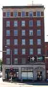
| 17 |
Hotel Chieftain |
|
02014-06-06-0000June 6, 2014
(#14000286) |
38 Pearl St.
41°15′36″N 95°51′03″W / 41.259881°N 95.850930°W / 41.259881; -95.850930 (Hotel Chieftain) |
Council Bluffs |
|
| 18 |
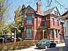
Martin Hughes House |
|
01984-09-27-0000September 27, 1984
(#84001310) |
903 3rd St.
41°15′11″N 95°50′53″W / 41.253056°N 95.848056°W / 41.253056; -95.848056 (Martin Hughes House) |
Council Bluffs |
|
| 19 |
Hughes-Irons Motor Company |
|
02011-06-23-0000June 23, 2011
(#11000392) |
149-161 W. Broadway
41°15′45″N 95°50′42″W / 41.2625°N 95.845°W / 41.2625; -95.845 (Hughes-Irons Motor Company) |
Council Bluffs |
|
| 20 |
Thomas Jefferis House |
|
01979-12-25-0000December 25, 1979
(#79000928) |
523 6th Ave.
41°15′21″N 95°51′07″W / 41.255833°N 95.851944°W / 41.255833; -95.851944 (Thomas Jefferis House) |
Council Bluffs |
|
| 21 |
Lincoln-Fairview Historic District |
Upload image |
02007-04-10-0000April 10, 2007
(#07000281) |
Roughly bounded by W. Kanesville Boulevard, Oakland Ave., Fairview Cemetery, and N. 1st St.
41°15′58″N 95°50′51″W / 41.266231°N 95.847633°W / 41.266231; -95.847633 (Lincoln-Fairview Historic District) |
Council Bluffs |
|
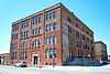
| 22 |
McCormick Harvesting Machine Company Building |
|
02012-09-10-0000September 10, 2012
(#12000780) |
1001 S. 6th St.
41°15′09″N 95°51′11″W / 41.252444°N 95.853022°W / 41.252444; -95.853022 (McCormick Harvesting Machine Company Building) |
Council Bluffs |
|
| 23 |
Charles Henry and Charlotte Norton House |
Upload image |
02004-12-30-0000December 30, 2004
(#04001401) |
401 N. Chestnut St.
41°28′47″N 95°20′11″W / 41.479722°N 95.336389°W / 41.479722; -95.336389 (Charles Henry and Charlotte Norton House) |
Avoca |
|
| 24 |
Park/Glen Avenues Historic District |
|
02010-04-07-0000April 7, 2010
(#10000160) |
101-508 Glen Ave., 102-471 Park Ave., 209 & 301 W. Pierce, & 524 & 600 Huntington
41°15′32″N 95°50′38″W / 41.258897°N 95.843767°W / 41.258897; -95.843767 (Park/Glen Avenues Historic District) |
Council Bluffs |
|
| 25 |
Pioneer Implement Company |
|
02008-04-30-0000April 30, 2008
(#08000357) |
1000 S. Main St.
41°15′09″N 95°51′06″W / 41.25244°N 95.85165°W / 41.25244; -95.85165 (Pioneer Implement Company) |
Council Bluffs |
|
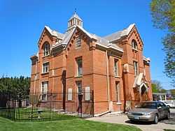
| 26 |
Pottawattamie County Jail |
|
01972-03-16-0000March 16, 1972
(#72000481) |
226 Pearl St.
41°16′35″N 95°50′39″W / 41.276389°N 95.844167°W / 41.276389; -95.844167 (Pottawattamie County Jail) |
Council Bluffs |
|
| 27 |
Pottawattamie County Sub Courthouse |
Upload image |
01981-07-02-0000July 2, 1981
(#81000265) |
Elm St.
41°28′41″N 95°20′19″W / 41.478056°N 95.338611°W / 41.478056; -95.338611 (Pottawattamie County Sub Courthouse) |
Avoca |
part of the County Courthouses in Iowa TR
|
| 28 |
Reverend Little's Young Ladies Seminary |
|
01982-02-04-0000February 4, 1982
(#82002637) |
541 6th Ave.
41°15′22″N 95°51′08″W / 41.256111°N 95.852222°W / 41.256111; -95.852222 (Reverend Little's Young Ladies Seminary) |
Council Bluffs |
|
| 29 |
St. Peter's Church and Rectory |
|
01992-07-24-0000July 24, 1992
(#92000923) |
1 Bluff St.
41°15′37″N 95°50′50″W / 41.260278°N 95.847222°W / 41.260278; -95.847222 (St. Peter's Church and Rectory) |
Council Bluffs |
|
| 30 |
Sandwich–Marseilles Manufacturing Building |
Upload image |
02014-05-27-0000May 27, 2014
(#14000253) |
1216–1230 S. Main St.
41°14′59″N 95°51′07″W / 41.249828°N 95.851968°W / 41.249828; -95.851968 (Sandwich–Marseilles Manufacturing Building) |
Council Bluffs |
|
| 31 |
John J. and Agnes Shea House |
|
01995-11-22-0000November 22, 1995
(#95001315) |
309 S. 8th St.
41°15′29″N 95°51′19″W / 41.258056°N 95.855278°W / 41.258056; -95.855278 (John J. and Agnes Shea House) |
Council Bluffs |
|
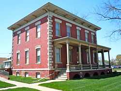
| 32 |
State Savings Bank |
|
01984-06-04-0000June 4, 1984
(#84001312) |
509 W. Broadway
41°15′39″N 95°51′02″W / 41.260833°N 95.850556°W / 41.260833; -95.850556 (State Savings Bank) |
Council Bluffs |
|
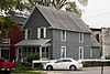
| 33 |
Lysander Tulleys House |
|
01979-10-18-0000October 18, 1979
(#79000929) |
151 Park Ave.
41°15′37″N 95°50′38″W / 41.260278°N 95.843889°W / 41.260278; -95.843889 (Lysander Tulleys House) |
Council Bluffs |
|
| 34 |
Francis A. and Rose M. Turner House |
Upload image |
01997-01-31-0000January 31, 1997
(#96001583) |
1004 Cherry St.
41°30′06″N 95°20′06″W / 41.501667°N 95.335°W / 41.501667; -95.335 (Francis A. and Rose M. Turner House) |
Avoca |
|
| 35 |
O.P. Wickham House |
|
01979-06-18-0000June 18, 1979
(#79000930) |
616 S. 7th St.
41°15′19″N 95°51′17″W / 41.255278°N 95.854722°W / 41.255278; -95.854722 (O.P. Wickham House) |
Council Bluffs |
|
| 36 |
Wickham-De Vol House |
|
01995-05-04-0000May 4, 1995
(#95000557) |
332 Willow Ave.
41°15′30″N 95°50′54″W / 41.258333°N 95.848333°W / 41.258333; -95.848333 (Wickham-De Vol House) |
Council Bluffs |
|
| 37 |
Willow-Bluff-3rd Street Historic District |
Upload image |
02005-09-15-0000September 15, 2005
(#05001019) |
Roughly bounded by Worth, High School Ave., Clark Ave., and the western side of Bluff St.
41°15′24″N 95°50′51″W / 41.256667°N 95.8475°W / 41.256667; -95.8475 (Willow-Bluff-3rd Street Historic District) |
Council Bluffs |
|
| 38 |
Y.M.C.A. Building |
|
01979-06-27-0000June 27, 1979
(#79000931) |
628 1st Ave.
41°15′37″N 95°51′13″W / 41.260278°N 95.853611°W / 41.260278; -95.853611 (Y.M.C.A. Building) |
Council Bluffs |
|