| [3] |
Name on the Register[4] |
Image |
Date listed[5] |
Location |
City or town |
Description |
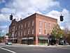
|---|
| 1 |
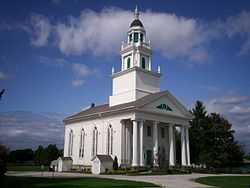
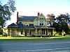
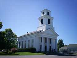
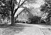
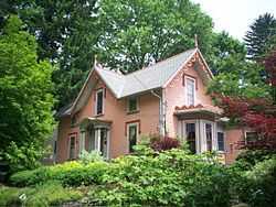
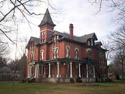
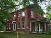
Atwater Congregational Church |
|
01973-02-23-0000February 23, 1973
(#73001517) |
1237 State Route 183 at Atwater
41°01′21″N 81°08′12″W / 41.0225°N 81.136667°W / 41.0225; -81.136667 (Atwater Congregational Church) |
Atwater Township |
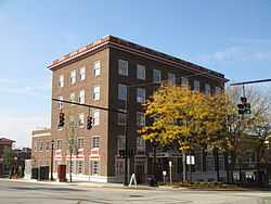
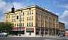
|
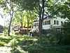
| 2 |
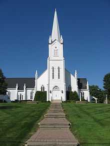
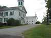
Aurora Center Historic District |
|
01974-06-20-0000June 20, 1974
(#74001601) |
Roughly both sides of State Route 306 from and including Pioneer Trail to State Route 82, also Maple Lane
41°18′49″N 81°20′50″W / 41.313611°N 81.347222°W / 41.313611; -81.347222 (Aurora Center Historic District) |
Aurora |
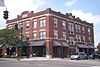
|
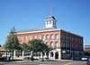
| 3 |
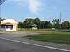
Aurora Train Station |
|
01986-05-22-0000May 22, 1986
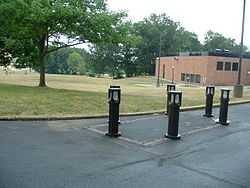
(#86001131) |
13 New Hudson Rd.
41°19′01″N 81°20′00″W / 41.316806°N 81.333333°W / 41.316806; -81.333333 (Aurora Train Station) |
Aurora |
|
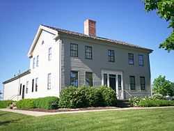
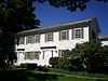
| 4 |
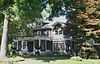
Horace Y. Beebe House |
Upload image |
01983-06-16-0000June 16, 1983
(#83002022) |
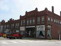
6538 Cleveland Rd., northwest of Ravenna
41°10′07″N 81°15′19″W / 41.168611°N 81.255278°W / 41.168611; -81.255278 (Horace Y. Beebe House) |
Ravenna Township |
|
| 5 |
John F. Byers House |
Upload image |
02008-07-02-0000July 2, 2008
(#08000590) |
5551 S. Prospect St., south of Ravenna
41°08′30″N 81°14′31″W / 41.141533°N 81.241825°W / 41.141533; -81.241825 (John F. Byers House) |
Ravenna Township |
|
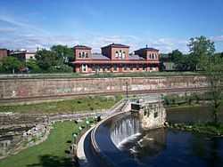
| 6 |
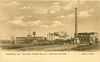
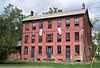
Cleveland Worsted Mills Redfern Mill |
|
01988-12-29-0000December 29, 1988
(#88003065) |
S. Chestnut St.
41°08′58″N 81°14′37″W / 41.149444°N 81.243611°W / 41.149444; -81.243611 (Cleveland Worsted Mills Redfern Mill) |
Ravenna |
|
| 7 |
Cottage Hill Farm |
Upload image |
01993-05-06-0000May 6, 1993
(#93000401) |
5555 Newton Falls Rd., east of Ravenna
41°09′54″N 81°11′45″W / 41.165°N 81.195833°W / 41.165; -81.195833 (Cottage Hill Farm) |
Ravenna Township |
|
| 8 |
William H. Crafts House |
Upload image |
01982-04-29-0000April 29, 1982
(#82003634) |
4619 W. Prospect St.
41°16′56″N 81°13′34″W / 41.282222°N 81.226111°W / 41.282222; -81.226111 (William H. Crafts House) |
Mantua |
|
| 9 |
Crystal Lake Stock Farm |
|
01986-04-10-0000April 10, 1986
(#86000698) |
4655 Hayes Rd., southeast of Ravenna
41°08′15″N 81°13′35″W / 41.1375°N 81.226389°W / 41.1375; -81.226389 (Crystal Lake Stock Farm) |
Ravenna Township |
|
| 10 |
John Davey House |
|
01975-05-29-0000May 29, 1975
(#75001524) |
338 Woodard St.
41°09′31″N 81°21′55″W / 41.158611°N 81.365278°W / 41.158611; -81.365278 (John Davey House) |
Kent |
|
| 11 |
John Diver House and Storebuilding |
|
01982-09-16-0000September 16, 1982
(#82003632) |
9465 Akron-Canfield Rd. at Deerfield
41°01′29″N 81°02′59″W / 41.024722°N 81.049722°W / 41.024722; -81.049722 (John Diver House and Storebuilding) |
Deerfield Township |
|
| 12 |
East Main Street Historic District |
|
01985-10-10-0000October 10, 1985
(#85003123) |
E. Main St. between Clinton and Linden Sts.
41°09′26″N 81°14′03″W / 41.157222°N 81.234167°W / 41.157222; -81.234167 (East Main Street Historic District) |
Ravenna |
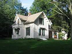
|
| 13 |
Ellenwood House |
Upload image |
01975-06-20-0000June 20, 1975
(#75001523) |
Northwest of Garrettsville on State Route 82
41°17′31″N 81°06′47″W / 41.291944°N 81.113056°W / 41.291944; -81.113056 (Ellenwood House) |
Hiram Township |
|
| 14 |
Etna House |
|
01985-07-25-0000July 25, 1985
(#85001641) |
219½ W. Main St.
41°09′26″N 81°14′38″W / 41.157222°N 81.243889°W / 41.157222; -81.243889 (Etna House) |
Ravenna |
|
| 15 |
Aaron Ferrey House |
|
01974-08-13-0000August 13, 1974
(#74001605) |
5058 Sunnybrook Rd.
41°07′38″N 81°21′55″W / 41.127222°N 81.365278°W / 41.127222; -81.365278 (Aaron Ferrey House) |
Kent |
|
| 16 |
Franklin Hotel |
|
02013-01-18-0000January 18, 2013
(#12000802) |
176 E. Main St.
41°09′12″N 81°21′24″W / 41.15343°N 81.356637°W / 41.15343; -81.356637 (Franklin Hotel) |
Kent |
|
| 17 |
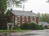
Franklin Township Hall |
|
01975-10-10-0000October 10, 1975
(#75001525) |
218 Gougler Ave.
41°09′19″N 81°21′38″W / 41.155278°N 81.360556°W / 41.155278; -81.360556 (Franklin Township Hall) |
Kent |
|
| 18 |
Freedom Congregational Church |
|
01975-07-07-0000July 7, 1975
(#75001521) |
Public Green on State Route 88 at Freedom
41°14′07″N 81°08′50″W / 41.235278°N 81.147222°W / 41.235278; -81.147222 (Freedom Congregational Church) |
Freedom Township |
|
| 19 |
James A. Garfield House |
|
01975-01-30-0000January 30, 1975
(#09000098) |
6825 Hinsdale St.
41°18′47″N 81°08′41″W / 41.313194°N 81.144722°W / 41.313194; -81.144722 (James A. Garfield House) |
Hiram |
|
| 20 |
A.B. Griffin-O.H. Griffin House |
|
01985-03-07-0000March 7, 1985
(#85000485) |
409 S. Walnut St.
41°09′16″N 81°14′25″W / 41.154444°N 81.240278°W / 41.154444; -81.240278 (A.B. Griffin-O.H. Griffin House) |
Ravenna |
|
| 21 |
Alexander B. Griffin House |
Upload image |
01987-07-02-0000July 2, 1987
(#87000987) |
417 S. Walnut St.
41°09′13″N 81°14′24″W / 41.153611°N 81.24°W / 41.153611; -81.24 (Alexander B. Griffin House) |
Ravenna |
|
| 22 |
Horace L. Hine House |
Upload image |
01976-12-12-0000December 12, 1976
(#76001513) |
4624 W. Prospect St.
41°16′54″N 81°13′32″W / 41.281667°N 81.225556°W / 41.281667; -81.225556 (Horace L. Hine House) |
Mantua |
|
| 23 |
Benjamin F. Hopkins Stone Building |
|
01982-11-25-0000November 25, 1982
(#82003633) |
Standing Rock Cemetery
41°09′55″N 81°21′11″W / 41.165278°N 81.353056°W / 41.165278; -81.353056 (Benjamin F. Hopkins Stone Building) |
Kent |
No longer at its original location
|
| 24 |
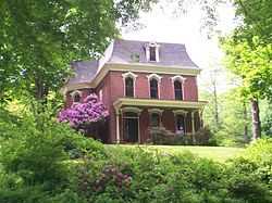
C.R. Howard House |
|
01974-08-13-0000August 13, 1974
(#74001602) |
411 E. Garfield St.
41°19′04″N 81°19′51″W / 41.317778°N 81.330833°W / 41.317778; -81.330833 (C.R. Howard House) |
Aurora |
|
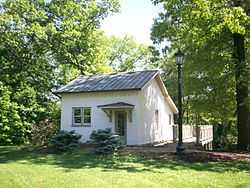
| 25 |
John Johnson Farm |
|
01976-12-12-0000December 12, 1976
(#76001512) |
6203 Pioneer Trail, southwest of Hiram
41°17′48″N 81°10′05″W / 41.296667°N 81.168056°W / 41.296667; -81.168056 (John Johnson Farm) |
Hiram Township |
|
| 26 |
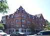
Kent Industrial District |
|
01974-12-30-0000December 30, 1974
(#74001603) |
Roughly bounded by West Main and River Streets, Haymaker Parkway, and Franklin Avenue
41°09′11″N 81°21′37″W / 41.153056°N 81.360278°W / 41.153056; -81.360278 (Kent Industrial District) |
Kent |
|
| 27 |
Kent Jail |
|
02001-08-22-0000August 22, 2001
(#01000895) |
947 Middlebury Rd.
41°09′00″N 81°22′07″W / 41.15°N 81.368611°W / 41.15; -81.368611 (Kent Jail) |
Kent |
Listed in 1978 at 124 W. Day St., but removed in 2000 before relisting at current location in 2001[4]
|
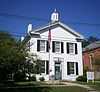
| 28 |
Charles Kent House |
|
01978-02-23-0000February 23, 1978
(#78002174) |
125 N. Pearl St.
41°09′15″N 81°21′56″W / 41.154167°N 81.365556°W / 41.154167; -81.365556 (Charles Kent House) |
Kent |
|
| 29 |
Zeno Kent House |
Upload image |
01973-04-23-0000April 23, 1973
(#73001518) |
2.5 mi (4.0 km) southwest of central Aurora on Aurora-Hudson Rd.
41°17′03″N 81°21′48″W / 41.284167°N 81.363333°W / 41.284167; -81.363333 (Zeno Kent House) |
Aurora |
|
| 30 |
Kent State Shootings Site |
|
02010-02-23-0000February 23, 2010
(#10000046) |
0.5 miles (0.80 km) southeast of the intersection of E. Main St. and S. Lincoln St.
41°09′00″N 81°20′40″W / 41.15°N 81.344444°W / 41.15; -81.344444 (Kent State Shootings Site) |
Kent |
Site of May 4, 1970, shootings of Vietnam War protesters by Ohio National Guardsmen that killed four.
|
| 31 |
Mantua Center District |
|
01974-10-09-0000October 9, 1974
(#74001607) |
Roughly bounded by State Route 82 and Mantua Center Rd., in Mantua Center
41°18′35″N 81°14′42″W / 41.309722°N 81.245°W / 41.309722; -81.245 (Mantua Center District) |
Mantua Township |
|
| 32 |
Mantua Center School |
|
02013-09-04-0000September 4, 2013
(#13000682) |
11741 Mantua Center Rd. at Mantua Center
41°18′41″N 81°14′42″W / 41.311389°N 81.245000°W / 41.311389; -81.245000 (Mantua Center School) |
Mantua Township |
|
| 33 |
Mantua Station Brick Commercial District |
|
01974-12-24-0000December 24, 1974
(#74001606) |
Main and Prospect Sts.
41°16′54″N 81°13′26″W / 41.281667°N 81.223889°W / 41.281667; -81.223889 (Mantua Station Brick Commercial District) |
Mantua |
|
| 34 |
Masonic Temple |
|
01974-07-18-0000July 18, 1974
(#74001604) |
409 W. Main St.
41°09′15″N 81°21′47″W / 41.154167°N 81.363056°W / 41.154167; -81.363056 (Masonic Temple) |
Kent |
|
| 35 |
Mott Drug Store |
Upload image |
01996-02-29-0000February 29, 1996
(#96000221) |
8107 Main St.
41°17′06″N 81°05′53″W / 41.285°N 81.098056°W / 41.285; -81.098056 (Mott Drug Store) |
Garrettsville |
|
| 36 |
Luman Nelson House |
|
01993-12-22-0000December 22, 1993
(#93001393) |
8219 State Route 44, north of Ravenna
41°12′53″N 81°14′33″W / 41.214722°N 81.2425°W / 41.214722; -81.2425 (Luman Nelson House) |
Shalersville Township |
|
| 37 |
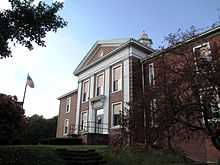
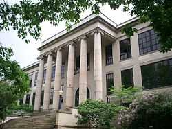
Ohio State Normal College at Kent |
|
01975-05-30-0000May 30, 1975
(#75001526) |
Hilltop Dr. on the Kent State University campus
41°09′06″N 81°20′53″W / 41.151667°N 81.348056°W / 41.151667; -81.348056 (Ohio State Normal College at Kent) |
Kent |
|
| 38 |
Arvin Olin House |
|
01995-10-20-0000October 20, 1995
(#95001157) |
1423 Ravenna Rd., north of Kent
41°11′02″N 81°20′33″W / 41.183889°N 81.3425°W / 41.183889; -81.3425 (Arvin Olin House) |
Franklin Township |
Demolished by the city of Akron on 10 March 2010[6]
|
| 39 |
Palmyra Center Hotel |
|
01976-04-30-0000April 30, 1976
(#76001514) |
County Road 18 and State Route 225 at Palmyra Center
41°05′57″N 81°03′07″W / 41.099167°N 81.051944°W / 41.099167; -81.051944 (Palmyra Center Hotel) |
Palmyra Township |
|
| 40 |
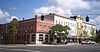
Phoenix Block |
|
01985-03-18-0000March 18, 1985
(#85000624) |
Northeastern corner of Main and Chestnut Sts.
41°09′28″N 81°14′37″W / 41.157778°N 81.243611°W / 41.157778; -81.243611 (Phoenix Block) |
Ravenna |
|
| 41 |
C.A. Reed House |
Upload image |
01985-10-10-0000October 10, 1985
(#85003116) |
299 W. Riddle St.
41°09′18″N 81°13′56″W / 41.155°N 81.232222°W / 41.155; -81.232222 (C.A. Reed House) |
Ravenna |
|
| 42 |
Riddle Block |
|
01976-03-17-0000March 17, 1976
(#76001515) |
Public Sq., Chestnut, and Main Sts.
41°09′26″N 81°14′35″W / 41.157222°N 81.243056°W / 41.157222; -81.243056 (Riddle Block) |
Ravenna |
|
| 43 |
Riddle Block No. 5 |
|
01985-07-25-0000July 25, 1985
(#85001642) |
141-145 E. Main St.
41°09′28″N 81°14′30″W / 41.157778°N 81.241667°W / 41.157778; -81.241667 (Riddle Block No. 5) |
Ravenna |
|
| 44 |
Riddle Block No. 9 |
|
01985-03-18-0000March 18, 1985
(#85000625) |
113-115 W. Main St.
41°09′28″N 81°14′37″W / 41.157778°N 81.243611°W / 41.157778; -81.243611 (Riddle Block No. 9) |
Ravenna |
|
| 45 |
Riddle Block No. 11 |
|
01985-03-18-0000March 18, 1985
(#85000626) |
133-137 E. Main St.
41°09′28″N 81°14′32″W / 41.157778°N 81.242222°W / 41.157778; -81.242222 (Riddle Block No. 11) |
Ravenna |
|
| 46 |
Frederick Wadsworth House |
|
01975-05-29-0000May 29, 1975
(#75001520) |
4889 State Route 14, northwest of Edinburg
41°07′21″N 81°10′48″W / 41.1225°N 81.18°W / 41.1225; -81.18 (Frederick Wadsworth House) |
Edinburg Township |
|
| 47 |
West Main Street District |
|
01977-06-17-0000June 17, 1977
(#77001082) |
409-625 W. Main St.
41°09′14″N 81°21′56″W / 41.153889°N 81.365556°W / 41.153889; -81.365556 (West Main Street District) |
Kent |
|
| 48 |
Thomas F. Young House |
|
01976-10-22-0000October 22, 1976
(#76001511) |
Wakefield and Garfield Sts.
41°18′35″N 81°08′40″W / 41.309722°N 81.144444°W / 41.309722; -81.144444 (Thomas F. Young House) |
Hiram |
|