National Register of Historic Places listings in Pope County, Arkansas

Location of Pope County in Arkansas
This is a list of the National Register of Historic Places listings in Pope County, Arkansas.
This is intended to be a complete list of the properties and districts on the National Register of Historic Places in Pope County, Arkansas, United States. The locations of National Register properties and districts for which the latitude and longitude coordinates are included below, may be seen in a Google map.[1]
There are 37 properties and districts listed on the National Register in the county.
- This National Park Service list is complete through NPS recent listings posted May 1, 2015.[2]
Current listings
| [3] | Name on the Register[4] | Image | Date listed[5] | Location | City or town | Description |
|---|---|---|---|---|---|---|
| 1 | Archeological Site 3PP141 | Upload image | (#06000837) |
Address Restricted |
Atkins | |
| 2 | Archeological Site 3PP142 | Upload image | (#06000839) |
Address Restricted |
Atkins | |
| 3 | Archeological Site 3PP614 | Upload image | (#07000203) |
Address Restricted |
Sand Gap | |
| 4 | Atkins Commercial Historic District | Upload image | (#09000739) |
Roughly bounded by Main, Church, and 1st Sts., Ave. 2. 35°14′33″N 92°56′18″W / 35.242544°N 92.938306°W |
Atkins | |
| 5 | Caraway Hall—Arkansas Tech University | 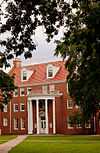 |
(#92001213) |
N. Arkansas St. 35°17′33″N 93°08′02″W / 35.2925°N 93.133889°W |
Russellville | |
| 6 | Center Valley Well House | 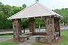 |
(#92001206) |
Highway 124 35°19′47″N 93°05′09″W / 35.329722°N 93.085833°W |
Center Valley | |
| 7 | Confederate Mothers Memorial Park | 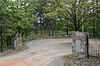 |
(#96000500) |
Junction of Highway 326 and S. Glenwood Ave. 35°15′30″N 93°08′26″W / 35.258333°N 93.140556°W |
Russellville | |
| 8 | Crow Mountain Petroglyph | Upload image | (#82004838) |
Address Restricted |
Dover | |
| 9 | Fair View School | 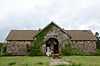 |
(#00000030) |
2367 Mill Creek Rd. 35°21′13″N 93°12′41″W / 35.353611°N 93.211389°W |
Russellville | |
| 10 | First Christian Church | 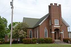 |
(#06000418) |
103 S. Boston Ave. 35°16′47″N 93°07′55″W / 35.279722°N 93.131944°W |
Russellville | |
| 11 | Girls' Domestic Science and Arts Building—Arkansas Tech University | 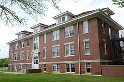 |
(#92001212) |
East of N. El Paso St. 35°17′33″N 93°08′04″W / 35.2925°N 93.134444°W |
Russellville | |
| 12 | Thomas J. Hankins House | Upload image | (#13000788) |
W. side of AR 7 approx. 375 ft. N. of jct. with AR 123 35°43′19″N 93°05′47″W / 35.722071°N 93.09652°W |
Pelsor | |
| 13 | Hughes Hall—Arkansas Tech University | 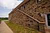 |
(#92001210) |
W. M St. 35°17′32″N 93°08′20″W / 35.292222°N 93.138889°W |
Russellville | |
| 14 | Henry R. Koen Forest Service Building | 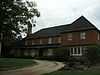 |
(#89001628) |
605 W. Main St. 35°16′43″N 93°08′20″W / 35.278611°N 93.138889°W |
Russellville | |
| 15 | Latimore Tourist Home | 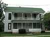 |
(#11001049) |
318 S. Houston Ave. 35°16′36″N 93°08′26″W / 35.276656°N 93.140483°W |
Russellville | part of the Arkansas Highway History and Architecture Multiple Property Submission |
| 16 | Little Rock to Cantonment Gibson Rd-Fourth Street Segment | Upload image | (#08001342) |
4th St. between Union Grove and Blackland Sts. 35°14′15″N 92°53′56″W / 35.237436°N 92.898761°W |
Atkins | A Trail of Tears site[6] |
| 17 | Missouri-Pacific Depot-Atkins | Upload image | (#92000600) |
U.S. Route 64 35°14′30″N 92°56′07″W / 35.241667°N 92.935278°W |
Atkins | |
| 18 | Missouri-Pacific Depot-Russellville | 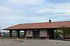 |
(#92000620) |
North of the junction of C St. and Denver Ave. 35°16′49″N 93°08′07″W / 35.280278°N 93.135278°W |
Russellville | |
| 19 | Mountain View School | 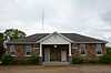 |
(#92001207) |
Highway 326 35°16′32″N 93°10′13″W / 35.275556°N 93.170278°W |
Russellville | |
| 20 | Norristown Cemetery | 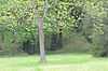 |
(#94001415) |
Off Highway 78 on Lock and Dam Rd. 35°14′35″N 93°09′01″W / 35.243056°N 93.150278°W |
Russellville | |
| 21 | Old South Restaurant | 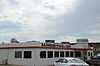 |
(#99001064) |
1330 E. Main St. 35°16′41″N 93°07′01″W / 35.278056°N 93.116944°W |
Russellville | |
| 22 | Physical Education Building—Arkansas Tech University | 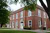 |
(#92001211) |
Southeastern corner of the junction of N. El Paso and W. O Sts. 35°17′36″N 93°08′11″W / 35.293333°N 93.136389°W |
Russellville | |
| 23 | Potts Inn | 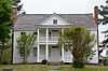 |
(#70000123) |
Main and Center Sts. 35°14′54″N 93°02′42″W / 35.248333°N 93.045°W |
Pottsville | |
| 24 | Pottsville Citizen's Bank | 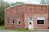 |
(#02000261) |
156 E. Ash St. 35°14′59″N 93°02′45″W / 35.249722°N 93.045833°W |
Pottsville | |
| 25 | Pottsville Commercial Historic District | 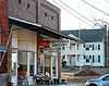 |
(#04001510) |
155, 160, 162, and 164 E. Ash St. 35°15′07″N 93°02′50″W / 35.251944°N 93.047222°W |
Pottsville | |
| 26 | Pottsville Dipping Vat | 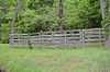 |
(#06000086) |
Corner of Rankin Park on E. Ash St. 35°15′08″N 93°02′48″W / 35.252222°N 93.046667°W |
Pottsville | |
| 27 | Riggs-Hamilton American Legion Post No. 20 | 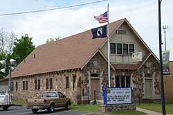 |
(#94000855) |
215 N. Denver Ave. 35°16′48″N 93°08′09″W / 35.28°N 93.135833°W |
Russellville | |
| 28 | Russellville Downtown Historic District | 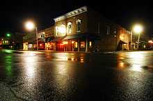 |
(#96000941) |
Roughly bounded by W. 2nd St., Arkansas Ave., the former Missouri Pacific railroad tracks, and El Paso St. 35°16′44″N 93°08′06″W / 35.278889°N 93.135°W |
Russellville | |
| 29 | Russellville Masonic Temple | 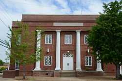 |
(#05000499) |
205 S. Commerce 35°16′39″N 93°08′07″W / 35.2775°N 93.135278°W |
Russellville | |
| 30 | Russellville Public Library | 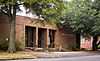 |
(#00001319) |
114 E. 3rd St. 35°16′32″N 93°08′00″W / 35.275556°N 93.133333°W |
Russellville | |
| 31 | Threlkeld House | 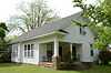 |
(#00000610) |
1301 N. Boston Ave. 35°17′27″N 93°07′56″W / 35.290833°N 93.132222°W |
Russellville | |
| 32 | Old US 64, Scotia Segment | 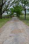 |
(#07000959) |
South of U.S. Route 64, east of Cedar Ln. 35°19′56″N 93°17′40″W / 35.332197°N 93.294358°W |
London | A Trail of Tears site[6] |
| 33 | John W. White House | 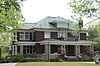 |
(#88000524) |
1509 W. Main St. 35°16′55″N 93°08′48″W / 35.281944°N 93.146667°W |
Russellville | |
| 34 | W.J. White House | 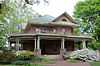 |
(#78000617) |
1412 W. Main St. 35°16′57″N 93°08′54″W / 35.2825°N 93.148333°W |
Russellville | |
| 35 | Williamson Hall—Arkansas Tech University | 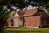 |
(#92001208) |
N. El Paso St. 35°17′25″N 93°08′13″W / 35.290278°N 93.136944°W |
Russellville | |
| 36 | Wilson Hall—Arkansas Tech University | 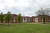 |
(#92001209) |
N. El Paso St. 35°17′33″N 93°08′15″W / 35.2925°N 93.1375°W |
Russellville | |
| 37 | Wilson House | 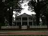 |
(#78000618) |
214 E. 5th St. 35°16′25″N 93°07′51″W / 35.273611°N 93.130833°W |
Russellville |
Former listings
| [3] | Name on the Register | Image | Date listed | Date removed | Location | City or town | Summary |
|---|---|---|---|---|---|---|---|
| 1 | Galla Creek Bridge | Upload image | (#93000090) | Old AR 64 over Galla Cr. |
Pottsville |
See also
| Wikimedia Commons has media related to National Register of Historic Places in Pope County, Arkansas. |
- List of National Historic Landmarks in Arkansas
- National Register of Historic Places listings in Arkansas
References
- ↑ The latitude and longitude information provided in this table was derived originally from the National Register Information System, which has been found to be fairly accurate for about 99% of listings. For about 1% of NRIS original coordinates, experience has shown that one or both coordinates are typos or otherwise extremely far off; some corrections may have been made. A more subtle problem causes many locations to be off by up to 150 yards, depending on location in the country: most NRIS coordinates were derived from tracing out latitude and longitudes off of USGS topographical quadrant maps created under the North American Datum of 1927, which differs from the current, highly accurate WGS84 GPS system used by most on-line maps. Chicago is about right, but NRIS longitudes in Washington are higher by about 4.5 seconds, and are lower by about 2.0 seconds in Maine. Latitudes differ by about 1.0 second in Florida. Some locations in this table may have been corrected to current GPS standards.
- ↑ "National Register of Historic Places: Weekly List Actions". National Park Service, United States Department of the Interior. Retrieved on May 1, 2015.
- ↑ 3.0 3.1 Numbers represent an ordering by significant words. Various colorings, defined here, differentiate National Historic Landmarks and historic districts from other NRHP buildings, structures, sites or objects.
- ↑ "National Register Information System". National Register of Historic Places. National Park Service. 2009-03-13.
- ↑ The eight-digit number below each date is the number assigned to each location in the National Register Information System database, which can be viewed by clicking the number.
- ↑ 6.0 6.1 "Trail Of Tears National Historic Trail: National Register Research". National Park Service. Retrieved January 22, 2013.
| ||||||||||||||||||||||||||