| [3] |
Name on the Register[4] |
Image |
Date listed[5] |
Location |
City or town |
Description |
|---|
| 1 |
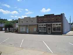
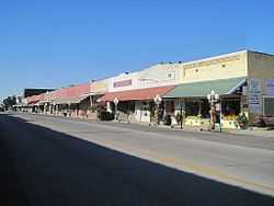
Bacon Hotel |
Upload image |
01995-12-13-0000December 13, 1995
(#95001437) |
Southeastern corner of the junction of Homestead Rd. and a railroad line
35°28′48″N 90°44′05″W / 35.48°N 90.734722°W / 35.48; -90.734722 (Bacon Hotel) |
Whitehall |
|
| 2 |
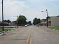
Harrisburg Commercial Historic District |
|
02009-09-18-0000September 18, 2009
(#09000736) |
Roughly bounded by Jackson, Water, South, and Gould Sts.
35°33′48″N 90°43′02″W / 35.563319°N 90.717206°W / 35.563319; -90.717206 (Harrisburg Commercial Historic District) |
Harrisburg |
|
| 3 |
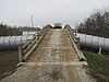
Highway A-7, Bridges Historic District |
Upload image |
02009-05-12-0000May 12, 2009
(#09000318) |
Old U.S. Route 63 over Ditch No. 1 and its reliefs
35°30′58″N 90°23′50″W / 35.516111°N 90.397222°W / 35.516111; -90.397222 (Highway A-7, Bridges Historic District) |
Marked Tree |
Historic Bridges of Arkansas MPS
|
| 4 |
Highway A-7, Ditch No. 6 Bridge |
Upload image |
02009-05-20-0000May 20, 2009
(#09000319) |
E. Davis St. over Ditch No. 6, southeast of Steel Bridge Rd.
35°28′55″N 90°20′37″W / 35.481944°N 90.343611°W / 35.481944; -90.343611 (Highway A-7, Ditch No. 6 Bridge) |
Tyronza |
|
| 5 |
Highway A-7, Tyronza Segment |
Upload image |
02009-05-20-0000May 20, 2009
(#09000320) |
Old U.S. Route 63 between Memphis Ave. and the Tyronza River
35°29′59″N 90°22′14″W / 35.49975°N 90.370661°W / 35.49975; -90.370661 (Highway A-7, Tyronza Segment) |
Tyronza |
|
| 6 |
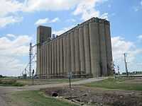
Hubbard Rice Dryer |
|
02004-10-01-0000October 1, 2004
(#04001070) |
15015 Senteney Rd.
35°40′04″N 90°45′54″W / 35.667778°N 90.765°W / 35.667778; -90.765 (Hubbard Rice Dryer) |
Weiner |
|
| 7 |
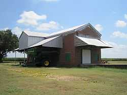
Judd Hill Cotton Gin |
|
02005-09-28-0000September 28, 2005
(#05001080) |
Highway 214 east of Bridgewood Rd.
35°36′12″N 90°31′06″W / 35.603333°N 90.518333°W / 35.603333; -90.518333 (Judd Hill Cotton Gin) |
Judd Hill |
|
| 8 |
Willie Lamb Post No. 26 American Legion Hut |
Upload image |
02003-01-08-0000January 8, 2003
(#02001674) |
205 Alexander St.
35°36′44″N 90°19′52″W / 35.612222°N 90.331111°W / 35.612222; -90.331111 (Willie Lamb Post No. 26 American Legion Hut) |
Lepanto |
|
| 9 |
Lepanto Commercial Historic District |
|
02009-09-21-0000September 21, 2009
(#09000743) |
Roughly bounded by Holmes St., the Little River, Dewey St., and Alexander Ave.
35°36′41″N 90°19′50″W / 35.611433°N 90.330447°W / 35.611433; -90.330447 (Lepanto Commercial Historic District) |
Lepanto |
|
| 10 |
Marked Tree Commercial Historic District |
Upload image |
02009-09-18-0000September 18, 2009
(#09000735) |
Elm St. between Liberty and Frisco Sts.; Frisco St. between Elm and Nathan Sts.
35°31′57″N 90°25′19″W / 35.532567°N 90.421825°W / 35.532567; -90.421825 (Marked Tree Commercial Historic District) |
Marked Tree |
|
| 11 |
Marked Tree Lock and Siphons |
|
01988-05-02-0000May 2, 1988
(#88000431) |
On the St. Francis River
35°35′10″N 90°25′47″W / 35.586111°N 90.429722°W / 35.586111; -90.429722 (Marked Tree Lock and Siphons) |
Marked Tree |
|
| 12 |
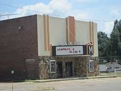
Maxie Theatre |
|
02011-04-07-0000April 7, 2011
(#10000933) |
136 Arkansas Highway 463 S.
35°40′14″N 90°30′59″W / 35.670556°N 90.516389°W / 35.670556; -90.516389 (Maxie Theatre) |
Trumann |
|
| 13 |
Modern News Building |
Upload image |
01976-06-18-0000June 18, 1976
(#76000447) |
216 N. Main St.
35°33′50″N 90°43′30″W / 35.563889°N 90.725°W / 35.563889; -90.725 (Modern News Building) |
Harrisburg |
|
| 14 |
Poinsett Community Club |
Upload image |
01986-10-09-0000October 9, 1986
(#86002847) |
Main and Poinsett Sts.
35°40′18″N 90°30′45″W / 35.671667°N 90.5125°W / 35.671667; -90.5125 (Poinsett Community Club) |
Trumann |
|
| 15 |
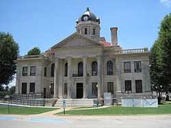
Poinsett County Courthouse |
|
01989-11-03-0000November 3, 1989
(#89001876) |
Bounded by Market, East, Court, and Main Sts.
35°33′47″N 90°43′02″W / 35.563056°N 90.717222°W / 35.563056; -90.717222 (Poinsett County Courthouse) |
Harrisburg |
|
| 16 |
Poinsett Lumber and Manufacturing Company Manager's House |
Upload image |
02010-01-21-0000January 21, 2010
(#09001257) |
512 Poinsett Ave.
35°40′28″N 90°31′01″W / 35.674583°N 90.516958°W / 35.674583; -90.516958 (Poinsett Lumber and Manufacturing Company Manager's House) |
Trumann |
|
| 17 |
Rivervale Inverted Siphons |
Upload image |
01991-03-22-0000March 22, 1991
(#91000339) |
Just southwest of Highway 135 across the Little River
35°40′19″N 90°20′21″W / 35.671944°N 90.339167°W / 35.671944; -90.339167 (Rivervale Inverted Siphons) |
Rivervale |
|
| 18 |
Tyronza Commercial Historic District |
|
02010-07-29-0000July 29, 2010
(#09000896) |
S. Main St. bounded on the north by Old U.S. Highway 63 and on the south by Mullins St.
35°29′27″N 90°21′31″W / 35.490833°N 90.358611°W / 35.490833; -90.358611 (Tyronza Commercial Historic District) |
Tyronza |
|
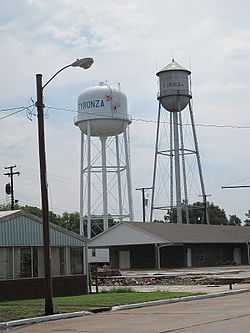
| 19 |
Tyronza Water Tower |
|
02007-09-20-0000September 20, 2007
(#07000963) |
Northwest of the junction of Main St. and Oliver St.
35°29′24″N 90°21′30″W / 35.49°N 90.358333°W / 35.49; -90.358333 (Tyronza Water Tower) |
Tyronza |
|