| [3] |
Name on the Register[4] |
Image |
Date listed[5] |
Location |
City or town |
Description |
|---|
| 1 |
Allin House |
Upload image |
01973-06-04-0000June 4, 1973
(#73000383) |
515 Columbia St.
34°31′38″N 90°35′30″W / 34.527222°N 90.591667°W / 34.527222; -90.591667 (Allin House) |
Helena-West Helena |
|
| 2 |
Almer Store |
Upload image |
01974-10-18-0000October 18, 1974
(#74000488) |
824 Columbia St.
34°31′42″N 90°35′20″W / 34.528333°N 90.588889°W / 34.528333; -90.588889 (Almer Store) |
Helena-West Helena |
|
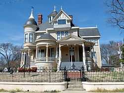
| 3 |
Altman House |
Upload image |
01988-01-21-0000January 21, 1988
(#87002497) |
1202 Perry St.
34°31′47″N 90°35′50″W / 34.529722°N 90.597222°W / 34.529722; -90.597222 (Altman House) |
Helena-West Helena |
|
| 4 |
Battery A Site, Battle of Helena |
Upload image |
01992-08-18-0000August 18, 1992
(#92001012) |
Northwest of the junction of Adams and Columbia Sts.
34°32′15″N 90°35′33″W / 34.5375°N 90.5925°W / 34.5375; -90.5925 (Battery A Site, Battle of Helena) |
Helena-West Helena |
|
| 5 |
Battery B Site, Battle of Helena |
Upload image |
01992-08-18-0000August 18, 1992
(#92001011) |
Northeast of the junction of Liberty St. and Summit Rd.
34°32′02″N 90°35′51″W / 34.533889°N 90.5975°W / 34.533889; -90.5975 (Battery B Site, Battle of Helena) |
Helena-West Helena |
|
| 6 |
Battery C Site |
|
01978-12-01-0000December 1, 1978
(#78000615) |
Clark and York Sts.
34°31′29″N 90°35′39″W / 34.524722°N 90.594167°W / 34.524722; -90.594167 (Battery C Site) |
Helena-West Helena |
|
| 7 |
Battery D |
Upload image |
01974-09-17-0000September 17, 1974
(#74000489) |
Military Rd.
34°31′05″N 90°35′22″W / 34.518056°N 90.589444°W / 34.518056; -90.589444 (Battery D) |
Helena-West Helena |
|
| 8 |
Beech Street Historic District |
Upload image |
01987-01-30-0000January 30, 1987
(#86003314) |
Roughly bounded by McDonough, Columbia, Beech, Elm, Perry, and College
34°31′38″N 90°35′48″W / 34.527222°N 90.596667°W / 34.527222; -90.596667 (Beech Street Historic District) |
Helena-West Helena |
|
| 9 |
Centennial Baptist Church |
|
01987-03-26-0000March 26, 1987
(#87000518) |
York and Columbia Sts.
34°31′32″N 90°35′27″W / 34.525556°N 90.590833°W / 34.525556; -90.590833 (Centennial Baptist Church) |
Helena-West Helena |
|
| 10 |
Cherry Street Historic District |
|
01987-08-17-0000August 17, 1987
(#86003546) |
Along Cherry St. between Porter and Elm Sts.; also Cherry St. between Porter and Perry Sts. and from Elm to the south side of Missouri St.
34°31′36″N 90°35′04″W / 34.526667°N 90.584444°W / 34.526667; -90.584444 (Cherry Street Historic District) |
Helena-West Helena |
Second set of addresses represents a boundary increase of 02010-05-27-0000May 27, 2010
|
| 11 |
Chicago Mill Company Office Building |
Upload image |
01996-10-31-0000October 31, 1996
(#96001133) |
129 N. Washington St.
34°32′39″N 90°39′22″W / 34.544167°N 90.656111°W / 34.544167; -90.656111 (Chicago Mill Company Office Building) |
Helena-West Helena |
|
| 12 |
Coolidge House |
Upload image |
01983-09-08-0000September 8, 1983
(#83001161) |
820 Perry St.
34°31′46″N 90°35′36″W / 34.529444°N 90.593333°W / 34.529444; -90.593333 (Coolidge House) |
Helena-West Helena |
|
| 13 |
Denison House |
Upload image |
01996-10-31-0000October 31, 1996
(#96001132) |
427 Garland Ave.
34°32′44″N 90°38′25″W / 34.545556°N 90.640278°W / 34.545556; -90.640278 (Denison House) |
Helena-West Helena |
|
| 14 |
Estevan Hall |
Upload image |
01974-10-22-0000October 22, 1974
(#74000491) |
653 S. Biscoe St.
34°30′48″N 90°35′37″W / 34.513333°N 90.593611°W / 34.513333; -90.593611 (Estevan Hall) |
Helena-West Helena |
|
| 15 |
Faust House |
|
01996-10-31-0000October 31, 1996
(#96001130) |
114 Richmond Hill
34°32′36″N 90°38′02″W / 34.543333°N 90.633889°W / 34.543333; -90.633889 (Faust House) |
Helena-West Helena |
|
| 16 |
First Baptist Church |
Upload image |
01991-05-13-0000May 13, 1991
(#91000587) |
Junction of Pine and Carruth Sts.
34°33′26″N 90°54′44″W / 34.557222°N 90.912222°W / 34.557222; -90.912222 (First Baptist Church) |
Marvell |
|
| 17 |
Henry and Cornelia Ford Farm |
Upload image |
02006-03-02-0000March 2, 2006
(#06000085) |
1335 County Road 249
34°37′12″N 90°42′28″W / 34.62°N 90.707778°W / 34.62; -90.707778 (Henry and Cornelia Ford Farm) |
Lexa |
|
| 18 |
Gemmill-Faust House |
Upload image |
01996-10-31-0000October 31, 1996
(#96001134) |
321 St. Andrew's Terrace
34°32′20″N 90°38′01″W / 34.538889°N 90.633611°W / 34.538889; -90.633611 (Gemmill-Faust House) |
Helena-West Helena |
|
| 19 |
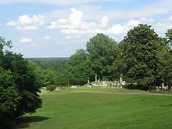
Helena Confederate Cemetery |
|
01996-05-03-0000May 3, 1996
(#96000501) |
Southwestern corner of Maple Hill Cemetery, approximately 0.5 miles north of the junction of Poplar and Adams Sts.
34°32′30″N 90°35′34″W / 34.541667°N 90.592778°W / 34.541667; -90.592778 (Helena Confederate Cemetery) |
Helena-West Helena |
|
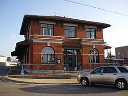
| 20 |
Helena Depot |
|
01987-11-05-0000November 5, 1987
(#87000877) |
Natchez and Missouri Sts.
34°31′19″N 90°35′09″W / 34.521944°N 90.585833°W / 34.521944; -90.585833 (Helena Depot) |
Helena-West Helena |
|
| 21 |
Helena Library and Museum |
Upload image |
01975-12-06-0000December 6, 1975
(#75000400) |
623 Peach St.
34°31′42″N 90°35′19″W / 34.528333°N 90.588611°W / 34.528333; -90.588611 (Helena Library and Museum) |
Helena-West Helena |
|
| 22 |
Helena National Guard Armory |
Upload image |
02007-01-24-0000January 24, 2007
(#06001266) |
511 Miller St.
34°31′53″N 90°35′19″W / 34.531339°N 90.588619°W / 34.531339; -90.588619 (Helena National Guard Armory) |
Helena-West Helena |
|
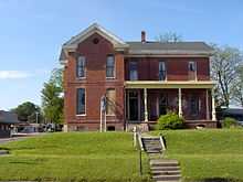
| 23 |
Sidney H. Horner House |
|
01975-12-04-0000December 4, 1975
(#75000401) |
626 Porter St.
34°31′41″N 90°35′26″W / 34.528056°N 90.590556°W / 34.528056; -90.590556 (Sidney H. Horner House) |
Helena-West Helena |
|
| 24 |
Keesee House |
Upload image |
01983-09-08-0000September 8, 1983
(#83001162) |
723 Arkansas St.
34°31′18″N 90°35′31″W / 34.521667°N 90.591944°W / 34.521667; -90.591944 (Keesee House) |
Helena-West Helena |
|
| 25 |
Richard L. Kitchens Post No. 41 |
|
01976-09-30-0000September 30, 1976
(#76000444) |
409 Porter St.
34°31′40″N 90°35′16″W / 34.527778°N 90.587778°W / 34.527778; -90.587778 (Richard L. Kitchens Post No. 41) |
Helena-West Helena |
|
| 26 |
Little Cypress Creek Bridge |
Upload image |
01995-05-18-0000May 18, 1995
(#95000611) |
County Road 66G over Little Cypress Creek
34°33′27″N 91°01′24″W / 34.5575°N 91.023333°W / 34.5575; -91.023333 (Little Cypress Creek Bridge) |
Postelle |
|
| 27 |
Louisiana Purchase Survey Marker |
|
01972-02-23-0000February 23, 1972
(#72000206) |
Southeast of Blackton at the corner of Monroe and Phillips counties
34°38′48″N 91°03′05″W / 34.646667°N 91.051389°W / 34.646667; -91.051389 (Louisiana Purchase Survey Marker) |
Blackton |
Extends into Lee and Monroe counties
|
| 28 |
Maple Hill Cemetery |
Upload image |
02000-04-06-0000April 6, 2000
(#00000318) |
N. Holly St.
34°32′35″N 90°35′28″W / 34.543056°N 90.591111°W / 34.543056; -90.591111 (Maple Hill Cemetery) |
Helena-West Helena |
|
| 29 |
Mayo House |
Upload image |
01997-12-19-0000December 19, 1997
(#97001513) |
302 Elm St.
34°33′28″N 90°54′44″W / 34.557778°N 90.912222°W / 34.557778; -90.912222 (Mayo House) |
Marvell |
|
| 30 |
Moore-Hornor House |
Upload image |
01973-06-04-0000June 4, 1973
(#73000384) |
323 Beech St.
34°31′31″N 90°36′08″W / 34.525278°N 90.602222°W / 34.525278; -90.602222 (Moore-Hornor House) |
Helena-West Helena |
|
| 31 |
Myers House |
|
01996-10-31-0000October 31, 1996
(#96001136) |
221 St. Andrew's Terrace
34°32′27″N 90°38′00″W / 34.540833°N 90.633333°W / 34.540833; -90.633333 (Myers House) |
Helena-West Helena |
|
| 32 |
Nelson House |
Upload image |
01996-10-31-0000October 31, 1996
(#96001135) |
303 St. Andrew's Terrace
34°32′22″N 90°38′00″W / 34.539444°N 90.633333°W / 34.539444; -90.633333 (Nelson House) |
Helena-West Helena |
|
| 33 |
New Light Missionary Baptist Church |
Upload image |
01995-12-07-0000December 7, 1995
(#95001410) |
522 Arkansas St.
34°31′18″N 90°35′25″W / 34.521667°N 90.590278°W / 34.521667; -90.590278 (New Light Missionary Baptist Church) |
Helena-West Helena |
|
| 34 |
Perry Street Historic District |
|
01986-11-26-0000November 26, 1986
(#86002954) |
Perry St. between Pecan and Franklin and Pecan St. from Porter to Perry
34°31′43″N 90°35′21″W / 34.528611°N 90.589167°W / 34.528611; -90.589167 (Perry Street Historic District) |
Helena-West Helena |
|
| 35 |
Phillips County Courthouse |
|
01977-07-15-0000July 15, 1977
(#77000265) |
622 Cherry St.
34°31′42″N 90°35′06″W / 34.528333°N 90.585°W / 34.528333; -90.585 (Phillips County Courthouse) |
Helena-West Helena |
|
| 36 |
Phillips County Penal Farm Historic District |
Upload image |
02007-01-24-0000January 24, 2007
(#06001268) |
County Road 353 south of U.S. Route 49
34°33′06″N 90°48′11″W / 34.551667°N 90.803056°W / 34.551667; -90.803056 (Phillips County Penal Farm Historic District) |
Poplar Grove |
|
| 37 |
Jerome Bonaparte Pillow House |
|
01973-05-07-0000May 7, 1973
(#73000385) |
718 Perry St.
34°31′44″N 90°35′31″W / 34.528889°N 90.591944°W / 34.528889; -90.591944 (Jerome Bonaparte Pillow House) |
Helena-West Helena |
|
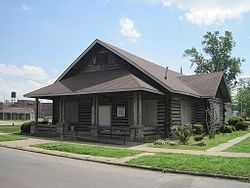
| 38 |
E.S. Ready House |
Upload image |
01976-01-01-0000January 1, 1976
(#76000445) |
929 Beech St.
34°31′55″N 90°35′33″W / 34.531944°N 90.5925°W / 34.531944; -90.5925 (E.S. Ready House) |
Helena-West Helena |
|
| 39 |
Richardson-Turner House |
Upload image |
01998-05-29-0000May 29, 1998
(#98000583) |
1469 Highway 1, N.
34°35′09″N 90°47′17″W / 34.585833°N 90.788056°W / 34.585833; -90.788056 (Richardson-Turner House) |
Lexa |
|
| 40 |
St. Mary's Catholic Church |
Upload image |
02007-01-24-0000January 24, 2007
(#06001278) |
123 Columbia
34°31′28″N 90°35′31″W / 34.524444°N 90.591944°W / 34.524444; -90.591944 (St. Mary's Catholic Church) |
Helena-West Helena |
|
| 41 |
William A. Short House |
Upload image |
01985-04-18-0000April 18, 1985
(#85000833) |
317 Biscoe St.
34°31′05″N 90°35′31″W / 34.518056°N 90.591944°W / 34.518056; -90.591944 (William A. Short House) |
Helena-West Helena |
|
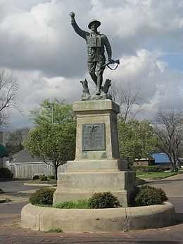
| 42 |
Spirit of the American Doughboy Monument-Helena |
|
01997-05-23-0000May 23, 1997
(#97000455) |
Junction of Cherry and Perry Sts.
34°31′42″N 90°35′06″W / 34.528333°N 90.585°W / 34.528333; -90.585 (Spirit of the American Doughboy Monument-Helena) |
Helena-West Helena |
|
| 43 |
William Nicholas Straub House |
Upload image |
01985-04-18-0000April 18, 1985
(#85000834) |
531 Perry St.
34°31′37″N 90°35′31″W / 34.526944°N 90.591944°W / 34.526944; -90.591944 (William Nicholas Straub House) |
Helena-West Helena |
|
| 44 |
James C. Tappan House |
Upload image |
01973-06-04-0000June 4, 1973
(#73002270) |
717 Poplar St.
34°31′46″N 90°35′38″W / 34.529444°N 90.593889°W / 34.529444; -90.593889 (James C. Tappan House) |
Helena-West Helena |
|
| 45 |
Maj. James Alexander Tappan House |
Upload image |
01974-09-09-0000September 9, 1974
(#74000493) |
727 Columbia St.
34°31′59″N 90°35′28″W / 34.533056°N 90.591111°W / 34.533056; -90.591111 (Maj. James Alexander Tappan House) |
Helena-West Helena |
|
| 46 |
Turner Historic District |
Upload image |
02006-03-02-0000March 2, 2006
(#06000073) |
Corners of Highway 318 and County Road 606
34°29′31″N 90°57′24″W / 34.491944°N 90.956667°W / 34.491944; -90.956667 (Turner Historic District) |
Cypert |
|
| 47 |
Warrens Bridge |
Upload image |
01995-05-18-0000May 18, 1995
(#95000612) |
County Road 14I over Lambrook Levee Ditch
34°20′09″N 91°00′42″W / 34.335833°N 91.011667°W / 34.335833; -91.011667 (Warrens Bridge) |
Lambrook |
|
| 48 |
West House |
Upload image |
01983-09-08-0000September 8, 1983
(#83001163) |
229 Beech St.
34°31′39″N 90°35′33″W / 34.5275°N 90.5925°W / 34.5275; -90.5925 (West House) |
Helena-West Helena |
|
| 49 |
White House |
Upload image |
01982-12-22-0000December 22, 1982
(#82000871) |
1015 Perry St.
34°31′57″N 90°35′56″W / 34.5325°N 90.598889°W / 34.5325; -90.598889 (White House) |
Helena-West Helena |
|