| [3] |
Name on the Register[4] |
Image |
Date listed[5] |
Location |
City or town |
Description |
|---|
| 1 |
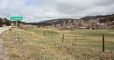
Boreas Railroad Station Site |
|
01993-10-28-0000October 28, 1993
(#93001108) |
Boreas Pass Rd. northwest of Como in the Pike National Forest
39°24′40″N 105°58′05″W / 39.411111°N 105.968056°W / 39.411111; -105.968056 (Boreas Railroad Station Site) |
Como |
|
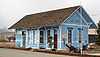
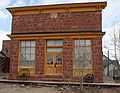
| 2 |
Buckley Ranch |
|
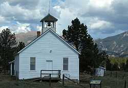
02000-01-28-0000January 28, 2000
(#99001667) |
County Road 59
39°00′55″N 105°43′48″W / 39.015278°N 105.73°W / 39.015278; -105.73 (Buckley Ranch) |
Hartsel |
|
| 3 |
Colorado Salt Works |
Upload image |
02001-02-02-0000February 2, 2001
(#01000033) |
3858 U.S. Route 285
38°57′11″N 105°56′43″W / 38.953056°N 105.945278°W / 38.953056; -105.945278 (Colorado Salt Works) |
Hartsel |
|
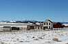
| 4 |
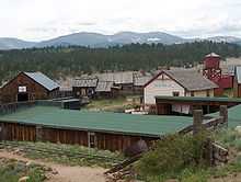
Como Roundhouse, Railroad Depot and Hotel Complex |
|
01983-05-20-0000May 20, 1983
(#83003880) |
Off U.S. Route 285
39°19′01″N 105°53′29″W / 39.316944°N 105.891389°W / 39.316944; -105.891389 (Como Roundhouse, Railroad Depot and Hotel Complex) |
Como |
Renovated Denver, South Park and Pacific Railroad roundhouse in Como, Colorado.
|
| 5 |
Como School |
|
02000-06-30-0000June 30, 2000
(#00000739) |
Spruce St.
39°19′01″N 105°53′48″W / 39.316944°N 105.896667°W / 39.316944; -105.896667 (Como School) |
Como |
|
| 6 |
EM Ranch |
Upload image |
02002-10-15-0000October 15, 2002
(#02001142) |
County Road 439
39°04′40″N 105°48′33″W / 39.077778°N 105.809167°W / 39.077778; -105.809167 (EM Ranch) |
Hartsel |
|
| 7 |
Estabrook Historic District |
Upload image |
01980-10-20-0000October 20, 1980
(#80000919) |
Northeast of Bailey
39°22′51″N 105°25′42″W / 39.380833°N 105.428333°W / 39.380833; -105.428333 (Estabrook Historic District) |
Bailey |
|
| 8 |
Fairplay Hotel |
|
02008-01-16-0000January 16, 2008
(#07001395) |
500 Main St.
39°13′29″N 106°00′03″W / 39.224722°N 106.000833°W / 39.224722; -106.000833 (Fairplay Hotel) |
Fairplay |
|
| 9 |
Glenisle |
|
01985-01-18-0000January 18, 1985
(#85000084) |
Off U.S. Route 285
39°24′34″N 105°30′00″W / 39.409444°N 105.5°W / 39.409444; -105.5 (Glenisle) |
Bailey |
|
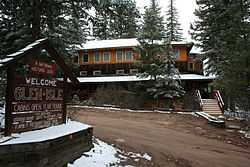
| 10 |
Jefferson Denver South Park and Pacific Railroad Depot |
|
01998-12-31-0000December 31, 1998
(#98001554) |
Junction of U.S. Route 285 and County Road 35
39°22′38″N 105°48′02″W / 39.377222°N 105.800556°W / 39.377222; -105.800556 (Jefferson Denver South Park and Pacific Railroad Depot) |
Jefferson |
|
| 11 |
Paris Mill |
Upload image |
02013-08-06-0000August 6, 2013
(#13000574) |
Address Restricted
|
Alma |
|
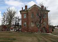
| 12 |
Park County Courthouse and Jail |
|
01979-05-25-0000May 25, 1979
(#79000618) |
418 Main St.
39°13′32″N 106°00′06″W / 39.225556°N 106.001667°W / 39.225556; -106.001667 (Park County Courthouse and Jail) |
Fairplay |
|
| 13 |
Salt Works Ranch |
Upload image |
02001-02-02-0000February 2, 2001
(#01000032) |
3858 U.S. Route 285
38°57′19″N 105°56′59″W / 38.955278°N 105.949722°W / 38.955278; -105.949722 (Salt Works Ranch) |
Hartsel |
|
| 14 |
Shawnee |
|
02010-07-08-0000July 8, 2010
(#10000434) |
56016-56114 Frontage Rd.; 55919-56278 U.S. Route 285; 31-36 W. Shawnee Rd.; 54-152 Waterworks Rd.
39°25′16″N 105°53′15″W / 39.421111°N 105.8875°W / 39.421111; -105.8875 (Shawnee) |
Shawnee |
|
| 15 |
South Park City Museum |
|
02014-11-05-0000November 5, 2014
(#14000899) |
100 4th St.
39°13′31″N 106°00′16″W / 39.2253°N 106.0044°W / 39.2253; -106.0044 (South Park City Museum) |
Fairplay |
|
| 16 |
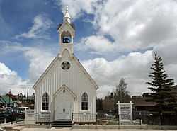
South Park Community Church |
|
01977-11-22-0000November 22, 1977
(#77000382) |
6th and Hathaway Sts.
39°13′29″N 105°59′57″W / 39.224722°N 105.999167°W / 39.224722; -105.999167 (South Park Community Church) |
Fairplay |
|
| 17 |
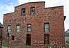
South Park Lager Beer Brewery |
|
01974-06-25-0000June 25, 1974
(#74000590) |
3rd and Front Sts.
39°13′32″N 106°00′12″W / 39.225556°N 106.003333°W / 39.225556; -106.003333 (South Park Lager Beer Brewery) |
Fairplay |
|
| 18 |
Staunton Ranch-Rural Historic Landscape |
Upload image |
02012-12-04-0000December 4, 2012
(#12000991) |
11559 Upper Ranch Dr.
39°30′17″N 105°23′24″W / 39.504628°N 105.389948°W / 39.504628; -105.389948 (Staunton Ranch-Rural Historic Landscape) |
Pine vicinity |
Extends into Jefferson County
|
| 19 |
Summer Saloon |
|
01974-05-08-0000May 8, 1974
(#74000591) |
3rd and Front Sts.
39°13′29″N 106°00′17″W / 39.224722°N 106.004722°W / 39.224722; -106.004722 (Summer Saloon) |
Fairplay |
|
| 20 |
Tarryall School |
|
01985-05-16-0000May 16, 1985
(#85001060) |
31000 County Rd.
39°07′14″N 105°28′25″W / 39.120556°N 105.473611°W / 39.120556; -105.473611 (Tarryall School) |
Tarryall |
|
| 21 |
Threemile Gulch |
Upload image |
02011-09-13-0000September 13, 2011
(#11000632) |
Feeding into the Middle Fork South Platte River, 3 miles (4.8 km) north of Hartsel[6]
39°03′42″N 105°47′34″W / 39.061667°N 105.792778°W / 39.061667; -105.792778 (Threemile Gulch) |
Hartsel |
|
| 22 |
Trout Creek--Annex--Settele Ranch |
Upload image |
02008-04-29-0000April 29, 2008
(#08000345) |
3242 Co.Rd. 7
39°07′33″N 105°54′11″W / 39.125841°N 105.903119°W / 39.125841; -105.903119 (Trout Creek--Annex--Settele Ranch) |
Fairplay |
|
| 23 |
Wahl Ranch |
|
02000-10-12-0000October 12, 2000
(#00001194) |
U.S. Route 285 and Lost Park Rd.
39°23′31″N 105°47′23″W / 39.391944°N 105.789722°W / 39.391944; -105.789722 (Wahl Ranch) |
Jefferson |
|