| [3] |
Name on the Register[4] |
Image |
Date listed[5] |
Location |
City or town |
Description |
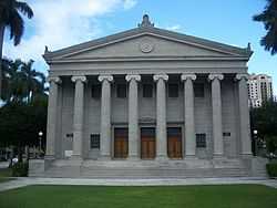
|---|
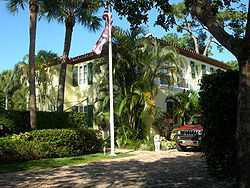
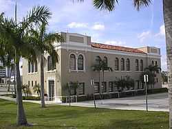
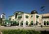
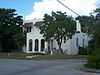
| 1 |
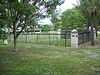
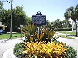
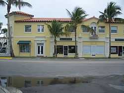
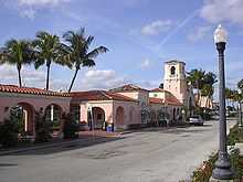
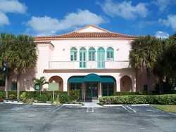
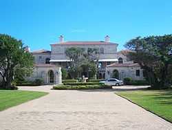
Administration Buildings |
|
01985-06-27-0000June 27, 1985
(#85001372) |
Dixie Highway and Camino Real
26°20′24″N 80°05′22″W / 26.34°N 80.089444°W / 26.34; -80.089444 (Administration Buildings) |
Boca Raton |
|
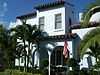
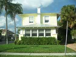
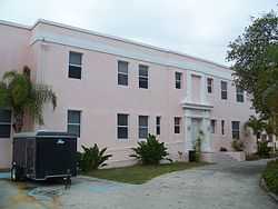
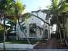
| 2 |
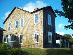
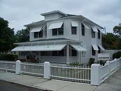
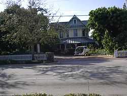
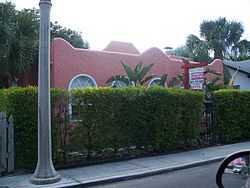
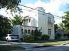
Fred C. Aiken House |
|
01992-09-24-0000September 24, 1992
(#92001271) |
801 Hibiscus Street
26°21′10″N 80°06′10″W / 26.352778°N 80.102778°W / 26.352778; -80.102778 (Fred C. Aiken House) |
Boca Raton |
|
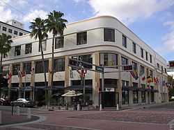
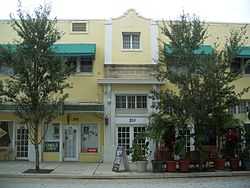
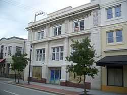
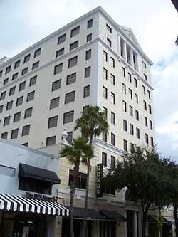
| 3 |
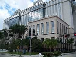
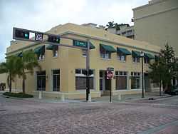
American National Bank Building |
|
01997-10-08-0000October 8, 1997
(#97001217) |
114 South Olive Avenue
26°42′42″N 80°03′12″W / 26.711667°N 80.053333°W / 26.711667; -80.053333 (American National Bank Building) |
West Palm Beach |
|
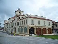
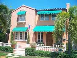
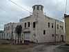
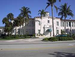
| 4 |
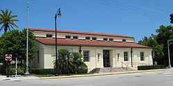
Old Belle Glade Town Hall |
|
02014-10-08-0000October 8, 2014
(#14000827) |
33 W. Ave. A
26°41′10″N 80°40′08″W / 26.686163°N 80.668906°W / 26.686163; -80.668906 (Old Belle Glade Town Hall) |
Belle Glade |
|
| 5 |
Big Mound City |
|
01973-05-24-0000May 24, 1973
(#73000596) |
Address Restricted
|
Canal Point |
|
| 6 |
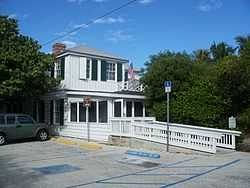
Boca Raton Fire Engine No. 1 |
Upload image |
02001-11-01-0000November 1, 2001
(#01001195) |
100 South Ocean Boulevard
26°20′59″N 80°04′13″W / 26.349722°N 80.070278°W / 26.349722; -80.070278 (Boca Raton Fire Engine No. 1) |
Boca Raton |
|
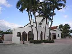
| 7 |
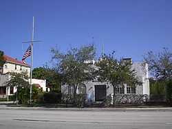
Boca Raton Old City Hall |
|
01980-10-16-0000October 16, 1980
(#80000958) |
71 North Federal Highway
26°21′03″N 80°05′13″W / 26.350833°N 80.086944°W / 26.350833; -80.086944 (Boca Raton Old City Hall) |
Boca Raton |
|
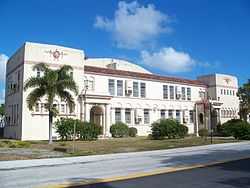
| 8 |
Boynton School |
|
01994-03-07-0000March 7, 1994
(#94000139) |
141 East Ocean Avenue
26°31′38″N 80°03′48″W / 26.527222°N 80.063333°W / 26.527222; -80.063333 (Boynton School) |
Boynton Beach |
|
| 9 |
Boynton Woman's Club |
|
01979-04-26-0000April 26, 1979
(#79000686) |
1010 South Federal Highway
26°31′07″N 80°03′30″W / 26.518611°N 80.058333°W / 26.518611; -80.058333 (Boynton Woman's Club) |
Boynton Beach |
|
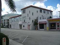
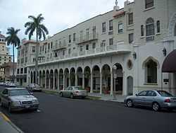
| 10 |
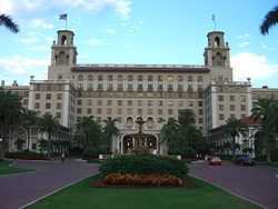
Breakers Hotel Complex |
|
01973-08-14-0000August 14, 1973
(#73000598) |
South County Road
26°42′54″N 80°02′02″W / 26.714909°N 80.03388°W / 26.714909; -80.03388 (Breakers Hotel Complex) |
Palm Beach |
|
| 11 |
Central Park Historic District |
|
01999-07-28-0000July 28, 1999
(#99000898) |
Roughly along State Road 805 and South Olive Avenue from Monroe Drive to Southern Boulevard
26°40′37″N 80°03′06″W / 26.676944°N 80.051667°W / 26.676944; -80.051667 (Central Park Historic District) |
West Palm Beach |
|
| 12 |
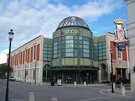
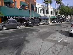
Clematis Street Historic Commercial District |
|
01998-10-08-0000October 8, 1998
(#98001230) |
500 block of Clematis Street
26°42′47″N 80°03′22″W / 26.713056°N 80.056111°W / 26.713056; -80.056111 (Clematis Street Historic Commercial District) |
West Palm Beach |
|
| 13 |
College Park Historic District |
|
02001-02-09-0000February 9, 2001
(#01000078) |
Roughly bounded by Maryland Drive, North Federal Highway, 19th Avenue North, and North Dixie Highway
26°38′24″N 80°03′17″W / 26.64°N 80.054722°W / 26.64; -80.054722 (College Park Historic District) |
Lake Worth |
|
| 14 |
Comeau Building |
|
01996-09-06-0000September 6, 1996
(#96000975) |
319 Clematis Street
26°42′48″N 80°03′09″W / 26.713333°N 80.0525°W / 26.713333; -80.0525 (Comeau Building) |
West Palm Beach |
|
| 15 |
Alfred J. Comeau House |
|
02000-03-24-0000March 24, 2000
(#00000238) |
701 Flamingo Drive
26°41′46″N 80°03′32″W / 26.696111°N 80.058889°W / 26.696111; -80.058889 (Alfred J. Comeau House) |
West Palm Beach |
|
| 16 |
Delray Beach Schools |
|
01988-03-10-0000March 10, 1988
(#88000210) |
Block 68
26°27′45″N 80°04′21″W / 26.4625°N 80.0725°W / 26.4625; -80.0725 (Delray Beach Schools) |
Delray Beach |
|
| 17 |
Eastover |
|
02002-12-23-0000December 23, 2002
(#02001694) |
1100 South Ocean Boulevard
26°34′13″N 80°02′25″W / 26.570278°N 80.040278°W / 26.570278; -80.040278 (Eastover) |
Manalapan |
|
| 18 |
El Cid Historic District |
|
01995-08-31-0000August 31, 1995
(#95001064) |
Roughly bounded by Flamingo Drive, South Flagler Drive, Dyer Road, and South Dixie Highway
26°41′31″N 80°03′05″W / 26.691944°N 80.051389°W / 26.691944; -80.051389 (El Cid Historic District) |
West Palm Beach |
|
| 19 |
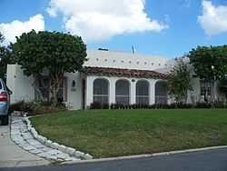
J. B. Evans House |
|
02002-03-28-0000March 28, 2002
(#02000265) |
142 South Ocean Boulevard
26°27′29″N 80°03′35″W / 26.458056°N 80.059722°W / 26.458056; -80.059722 (J. B. Evans House) |
Delray Beach |
|
| 20 |
Ferndix Building |
|
01999-07-22-0000July 22, 1999
(#99000861) |
401 Fern Street
26°42′38″N 80°03′15″W / 26.710556°N 80.054167°W / 26.710556; -80.054167 (Ferndix Building) |
West Palm Beach |
|
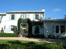
| 21 |
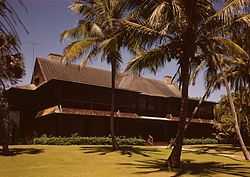
Henry Morrison Flagler House: Whitehall |
|
01972-12-05-0000December 5, 1972
(#72000345) |
Whitehall Way
26°42′49″N 80°02′38″W / 26.713611°N 80.043889°W / 26.713611; -80.043889 (Henry Morrison Flagler House: Whitehall) |
Palm Beach |
|
| 22 |
Flamingo Park Historic Residential District |
|
02000-07-14-0000July 14, 2000
(#00000785) |
Roughly bounded by Park Place, Parker Avenue, Beleveder Road, and Florida Avenue
26°41′33″N 80°03′38″W / 26.6925°N 80.060556°W / 26.6925; -80.060556 (Flamingo Park Historic Residential District) |
West Palm Beach |
|
| 23 |
Florida East Coast Railway Passenger Station |
|
01980-10-24-0000October 24, 1980
(#80000959) |
Off State Road 808
26°20′33″N 80°05′21″W / 26.3425°N 80.089167°W / 26.3425; -80.089167 (Florida East Coast Railway Passenger Station) |
Boca Raton |
|
| 24 |
Grandview Heights Historic District |
|
01999-07-08-0000July 8, 1999
(#99000795) |
Roughly bounded by Park Place, Alabama Avenue, M Street, and South Lake Avenue
26°37′30″N 80°02′27″W / 26.625°N 80.040833°W / 26.625; -80.040833 (Grandview Heights Historic District) |
West Palm Beach |
|
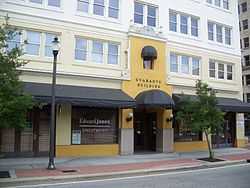
| 25 |
Guaranty Building |
|
01998-12-10-0000December 10, 1998
(#98001483) |
120 South Olive Avenue
26°42′44″N 80°03′04″W / 26.712222°N 80.051111°W / 26.712222; -80.051111 (Guaranty Building) |
West Palm Beach |
|
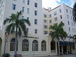
| 26 |
Gulf Stream Hotel |
|
01983-01-11-0000January 11, 1983
(#83001435) |
1 Lake Avenue
26°36′55″N 80°02′56″W / 26.615278°N 80.048889°W / 26.615278; -80.048889 (Gulf Stream Hotel) |
Lake Worth |
|
| 27 |
Hatch's Department Store |
|
01994-04-14-0000April 14, 1994
(#94000348) |
301-307 Clematis Street
26°42′49″N 80°03′08″W / 26.713611°N 80.052222°W / 26.713611; -80.052222 (Hatch's Department Store) |
West Palm Beach |
|
| 28 |
Historic Old Town Commercial District |
|
02001-09-22-0000September 22, 2001
(#01001011) |
Bounded by FEC, M Street, Lucerne Avenue, and 1st Avenue S
26°37′25″N 80°01′51″W / 26.623611°N 80.030833°W / 26.623611; -80.030833 (Historic Old Town Commercial District) |
Lake Worth |
|
| 29 |
House at 1240 Cocoanut Road |
|
02001-08-17-0000August 17, 2001
(#01000888) |
1240 Cocoanut Road
26°19′56″N 80°04′36″W / 26.332222°N 80.076667°W / 26.332222; -80.076667 (House at 1240 Cocoanut Road) |
Boca Raton |
|
| 30 |
Hurricane of 1928 African American Mass Burial Site |
|
02002-09-12-0000September 12, 2002
(#02001012) |
Junction of 25th Street and Tamarind Avenue
26°44′09″N 80°03′42″W / 26.735833°N 80.061667°W / 26.735833; -80.061667 (Hurricane of 1928 African American Mass Burial Site) |
West Palm Beach |
|
| 31 |
Jupiter Inlet Historic and Archeological Site |
|
01985-11-05-0000November 5, 1985
(#85003486) |
Address Restricted
|
Jupiter |
|
| 32 |
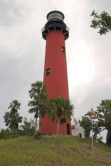
Jupiter Inlet Lighthouse |
|
01973-10-15-0000October 15, 1973
(#73000597) |
Junction of the Loxahatchee River and Jupiter Sound
26°56′50″N 80°04′47″W / 26.947222°N 80.079722°W / 26.947222; -80.079722 (Jupiter Inlet Lighthouse) |
Jupiter |
|
| 33 |
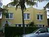
Kelsey City City Hall |
|
01981-09-03-0000September 3, 1981
(#81000195) |
535 Park Avenue
26°47′57″N 80°04′17″W / 26.799167°N 80.071389°W / 26.799167; -80.071389 (Kelsey City City Hall) |
Lake Park |
|
| 34 |
Lavender House |
|
01995-02-24-0000February 24, 1995
(#95000165) |
875 Alamanda Street
26°21′04″N 80°06′15″W / 26.351111°N 80.104167°W / 26.351111; -80.104167 (Lavender House) |
Boca Raton |
|
| 35 |
Lofthus (shipwreck) |
|
02004-01-06-0000January 6, 2004
(#03001363) |
¾ mile north of Boynton Inlet, 175 yards offshore
26°33′47″N 80°02′23″W / 26.563056°N 80.039722°W / 26.563056; -80.039722 (Lofthus (shipwreck)) |
Boynton Beach |
|
| 36 |
Mango Promenade Historic District |
|
01999-07-08-0000July 8, 1999
(#99000801) |
Roughly bounded by South Dixie Highway, Austin Lane, Coconut Lane, and Cranesnest Way
26°41′51″N 80°03′12″W / 26.6975°N 80.053333°W / 26.6975; -80.053333 (Mango Promenade Historic District) |
West Palm Beach |
|
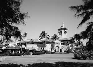
| 37 |
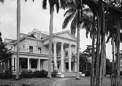
Mar-A-Lago National Historic Landmark |
|
01980-12-23-0000December 23, 1980
(#80000961) |
1100 South Ocean Boulevard
26°40′40″N 80°02′10″W / 26.677778°N 80.036111°W / 26.677778; -80.036111 (Mar-A-Lago National Historic Landmark) |
Palm Beach |
|
| 38 |
Marina Historic District |
|
02014-06-02-0000June 2, 2014
(#14000268) |
Bounded by E. Atlantic Ave., Marine Way, SE 4th Str, SE 7th Ave.
26°27′30″N 80°03′56″W / 26.4583109°N 80.065674°W / 26.4583109; -80.065674 (Marina Historic District) |
Delray Beach |
|
| 39 |
Mickens House |
|
01985-04-11-0000April 11, 1985
(#85000769) |
801 4th Street
26°43′02″N 80°03′36″W / 26.717222°N 80.06°W / 26.717222; -80.06 (Mickens House) |
West Palm Beach |
|
| 40 |
Milton-Myers American Legion Post No. 65 |
|
01995-04-20-0000April 20, 1995
(#95000471) |
263 Northeast 5th Avenue
26°27′57″N 80°04′05″W / 26.465833°N 80.068056°W / 26.465833; -80.068056 (Milton-Myers American Legion Post No. 65) |
Delray Beach |
|
| 41 |
Northboro Park Historic District |
|
02007-02-20-0000February 20, 2007
(#07000059) |
Bounded by 40th N., Flagler Drive, 36th Street, and Broadway
26°44′51″N 80°03′16″W / 26.7475°N 80.054444°W / 26.7475; -80.054444 (Northboro Park Historic District) |
West Palm Beach |
|
| 42 |
Northwest Historic District |
|
01992-01-22-0000January 22, 1992
(#91002005) |
Roughly bounded by Tamarind Avenue, Eleventh Street, Rosemary Avenue, and Third Street
26°43′09″N 80°03′34″W / 26.719167°N 80.059444°W / 26.719167; -80.059444 (Northwest Historic District) |
West Palm Beach |
|
| 43 |
Norton House |
|
01990-07-26-0000July 26, 1990
(#90001106) |
253 Barcelona Road
26°41′42″N 80°03′03″W / 26.695°N 80.050833°W / 26.695; -80.050833 (Norton House) |
West Palm Beach |
|
| 44 |
Old Lake Worth City Hall |
|
01989-05-18-0000May 18, 1989
(#89000432) |
414 Lake Avenue
26°36′57″N 80°03′18″W / 26.615833°N 80.055°W / 26.615833; -80.055 (Old Lake Worth City Hall) |
Lake Worth |
|
| 45 |
Old Northwood Historic District |
|
01994-04-14-0000April 14, 1994
(#94000368) |
Roughly bounded by Broadway, North Dixie Highway, and 26th and 35th Streets
26°44′28″N 80°03′17″W / 26.741111°N 80.054722°W / 26.741111; -80.054722 (Old Northwood Historic District) |
West Palm Beach |
|
| 46 |
Old Lucerne Historic Residential District |
|
02001-06-04-0000June 4, 2001
(#01000526) |
Roughly along North Lakeside Drive, North Palmway Street, and North O Street, from Lake Avenue to 7th Avenue, N.
26°37′10″N 80°03′04″W / 26.619444°N 80.051111°W / 26.619444; -80.051111 (Old Lucerne Historic Residential District) |
Lake Worth |
|
| 47 |
Old Palm Beach Junior College Building |
|
01991-05-30-0000May 30, 1991
(#91000601) |
813 Gardenia Avenue
26°42′34″N 80°03′38″W / 26.709444°N 80.060556°W / 26.709444; -80.060556 (Old Palm Beach Junior College Building) |
West Palm Beach |
|
| 48 |
Old West Palm Beach National Guard Armory |
|
01992-06-11-0000June 11, 1992
(#92000142) |
1703 South Lake Avenue
26°41′53″N 80°03′41″W / 26.698056°N 80.061389°W / 26.698056; -80.061389 (Old West Palm Beach National Guard Armory) |
West Palm Beach |
|
| 49 |
Osborne School |
|
02003-08-01-0000August 1, 2003
(#03000701) |
1718 South Douglas Street
26°35′39″N 80°03′22″W / 26.594167°N 80.056111°W / 26.594167; -80.056111 (Osborne School) |
Lake Worth |
Part of the Florida's Historic Black Public Schools MPS
|
| 50 |
Pahokee High School |
|
01996-11-15-0000November 15, 1996
(#96001334) |
360 Main Street
26°49′30″N 80°39′48″W / 26.825°N 80.663333°W / 26.825; -80.663333 (Pahokee High School) |
Pahokee |
|
| 51 |
Palm Beach Daily News Building |
|
01985-12-24-0000December 24, 1985
(#85003121) |
204 Brazilian Avenue
26°42′13″N 80°02′13″W / 26.703611°N 80.036944°W / 26.703611; -80.036944 (Palm Beach Daily News Building) |
Palm Beach |
|
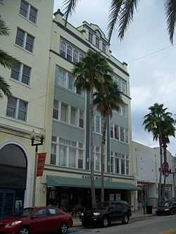
| 52 |
Palm Beach Hotel |
|
02010-04-21-0000April 21, 2010
(#10000212) |
235-251 Sunrise Ave.
26°43′13″N 80°02′23″W / 26.720278°N 80.039722°W / 26.720278; -80.039722 (Palm Beach Hotel) |
Palm Beach |
|
| 53 |
Palm Beach Mercantile Company |
|
01994-01-28-0000January 28, 1994
(#93001552) |
206 Clematis Street
26°42′46″N 80°03′08″W / 26.712778°N 80.052222°W / 26.712778; -80.052222 (Palm Beach Mercantile Company) |
West Palm Beach |
|
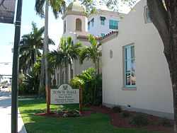
| 54 |
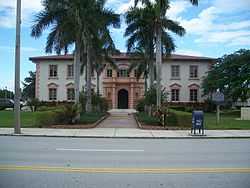
Palm Beach Town Hall |
|
02005-01-28-0000January 28, 2005
(#04001571) |
360 South County Road
26°42′09″N 80°02′12″W / 26.7025°N 80.036667°W / 26.7025; -80.036667 (Palm Beach Town Hall) |
Palm Beach |
|
| 55 |
Paramount Theatre Building |
|
01973-12-12-0000December 12, 1973
(#73000599) |
145 North County Road
26°43′09″N 80°02′14″W / 26.719167°N 80.037222°W / 26.719167; -80.037222 (Paramount Theatre Building) |
Palm Beach |
|
| 56 |
Pine Ridge Hospital |
|
02001-01-26-0000January 26, 2001
(#00001675) |
1401 Division Avenue
26°43′31″N 80°03′39″W / 26.725278°N 80.060833°W / 26.725278; -80.060833 (Pine Ridge Hospital) |
West Palm Beach |
|
| 57 |
Professional Building |
|
01996-10-24-0000October 24, 1996
(#96001187) |
310 South Dixie Highway
26°42′39″N 80°03′13″W / 26.710833°N 80.053611°W / 26.710833; -80.053611 (Professional Building) |
West Palm Beach |
|
| 58 |
Prospect Park-Southland Park Historic District |
|
02011-04-08-0000April 8, 2011
(#11000181) |
Bounded by Lake Worth, S Dixie HWY, Monceaux Rd, Monroe Dr,
26°41′03″N 80°03′05″W / 26.684167°N 80.051389°W / 26.684167; -80.051389 (Prospect Park-Southland Park Historic District) |
West Palm Beach |
|
| 59 |
Clifton Rice House |
|
01996-04-26-0000April 26, 1996
(#96000466) |
714 Claremore Drive
26°41′40″N 80°03′34″W / 26.694444°N 80.059444°W / 26.694444; -80.059444 (Clifton Rice House) |
West Palm Beach |
|
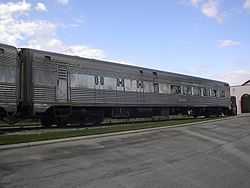
| 60 |
Seaboard Air Line Dining Car-6113 |
|
02001-04-05-0000April 5, 2001
(#01000334) |
747 South Dixie Highway
26°20′32″N 80°05′22″W / 26.342222°N 80.089444°W / 26.342222; -80.089444 (Seaboard Air Line Dining Car-6113) |
Boca Raton |
Florida's Historic Railroad Resources MPS
|
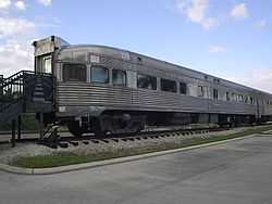
| 61 |
Seaboard Air Line Lounge Car-6603 |
|
02001-04-05-0000April 5, 2001
(#01000335) |
747 South Dixie Highway
26°20′32″N 80°05′22″W / 26.342222°N 80.089444°W / 26.342222; -80.089444 (Seaboard Air Line Lounge Car-6603) |
Boca Raton |
Florida's Historic Railroad Resources MPS
|
| 62 |
Seaboard Airline Railroad Station |
|
01986-09-04-0000September 4, 1986
(#86002172) |
1525 West Atlantic Avenue
26°51′33″N 80°05′17″W / 26.859167°N 80.088056°W / 26.859167; -80.088056 (Seaboard Airline Railroad Station) |
Delray Beach |
|
| 63 |
Seaboard Coastline Railroad Passenger Station |
|
01973-06-19-0000June 19, 1973
(#73000600) |
Tamarind Avenue at Datura Street
26°42′44″N 80°03′44″W / 26.712222°N 80.062222°W / 26.712222; -80.062222 (Seaboard Coastline Railroad Passenger Station) |
West Palm Beach |
|
| 64 |
John and Elizabeth Shaw Sundy House |
|
01992-01-16-0000January 16, 1992
(#91001910) |
106 South Swinton Avenue
26°27′33″N 80°04′25″W / 26.459167°N 80.073611°W / 26.459167; -80.073611 (John and Elizabeth Shaw Sundy House) |
Delray Beach |
|
| 65 |
US Post Office |
|
01983-07-21-0000July 21, 1983
(#83001436) |
95 North County Road
26°43′05″N 80°02′18″W / 26.718056°N 80.038333°W / 26.718056; -80.038333 (US Post Office) |
Palm Beach |
|
| 66 |
Vedado Historic District |
|
02010-10-15-0000October 15, 2010
(#10000821) |
Roughly bounded Merril Ave, Southern Blvd, Parker Ave & Paseo Morella
26°40′39″N 80°03′54″W / 26.6775°N 80.065°W / 26.6775; -80.065 (Vedado Historic District) |
West Palm Beach |
|
| 67 |
Grant Van Valkenburg House |
|
01999-08-02-0000August 2, 1999
(#99000860) |
213 Rosemary Avenue
26°42′41″N 80°03′26″W / 26.711389°N 80.057222°W / 26.711389; -80.057222 (Grant Van Valkenburg House) |
West Palm Beach |
|
| 68 |
Via Mizner |
|
01993-04-01-0000April 1, 1993
(#93000256) |
337-339 Worth Avenue
26°42′04″N 80°02′26″W / 26.701111°N 80.040556°W / 26.701111; -80.040556 (Via Mizner) |
Palm Beach |
|
| 69 |
Vineta Hotel |
|
01986-08-21-0000August 21, 1986
(#86001724) |
363 Cocoanut Row
26°42′10″N 80°02′28″W / 26.702778°N 80.041111°W / 26.702778; -80.041111 (Vineta Hotel) |
Palm Beach |
|
| 70 |
William Gray Warden House |
|
01984-08-01-0000August 1, 1984
(#84000940) |
112 Seminole Avenue
26°43′17″N 80°02′08″W / 26.721389°N 80.035556°W / 26.721389; -80.035556 (William Gray Warden House) |
Palm Beach |
|


.jpg)