National Register of Historic Places listings in Ozaukee County, Wisconsin
Buildings, sites, structures, districts, and objects in Ozaukee County listed on the National Register of Historic Places
- This National Park Service list is complete through NPS recent listings posted May 1, 2015.[1]
Current listings
| [2] | Name on the Register | Image | Date listed[3] | Location | City or town | Description |
|---|---|---|---|---|---|---|
| 1 | Bigelow School | 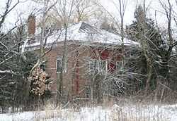 |
(#00000851) |
4228 W. Bonniwell Rd. 43°15′57″N 87°57′42″W / 43.265833°N 87.961667°W |
Mequon | |
| 2 | Harry W. Bolens House | 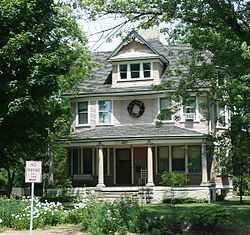 |
(#83003407) |
842 W. Grand Ave. 43°23′14″N 87°53′14″W / 43.387222°N 87.887222°W |
Port Washington | Home of Port Washington mayor and 1930's state senator. |
| 3 | Cedarburg Mill | 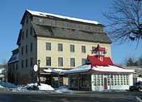 |
(#74000115) |
215 E. Columbia Ave. 43°17′48″N 87°59′10″W / 43.296667°N 87.986111°W |
Cedarburg | 1855 gristmill |
| 4 | Cedarburg Woolen Co. Worsted Mill | 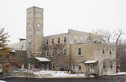 |
(#83003408) |
1350 14th Ave. 43°19′03″N 87°56′57″W / 43.3175°N 87.949167°W |
Grafton | |
| 5 | Jonathan Clark House | |
(#82000692) |
13615 N. Cedarburg Rd. 43°15′57″N 87°59′23″W / 43.265833°N 87.989722°W |
Mequon | |
| 6 | Columbia Historic District | 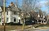 |
(#91001980) |
Roughly bounded by Cedar Cr., Highland Dr. and Bridge Rd. 43°17′59″N 87°58′57″W / 43.299722°N 87.9825°W |
Cedarburg | Residential neighborhood anchored by Trinity Lutheran Church |
| 7 | Concordia Mill |  |
(#74000116) |
252 Green Bay Rd. 43°17′05″N 87°58′13″W / 43.284722°N 87.970278°W |
Cedarburg | |
| 8 | Covered Bridge |  |
(#73000092) |
1 Mi. N of Five Corners over Cedar Creek 43°20′16″N 88°00′16″W / 43.337778°N 88.004444°W |
Cedarburg | The last remaining original covered bridge in Wisconsin. Built 1876, retired 1962 |
| 9 | Isham Day House | 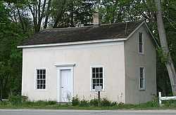 |
(#00001558) |
11312 N. Cedarburg Rd. 43°13′25″N 87°59′00″W / 43.223611°N 87.983333°W |
Mequon | 1839 New England Yankee pioneer style home |
| 10 | Edward Dodge House | 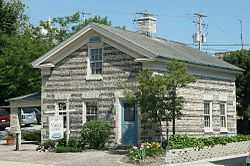 |
(#75000074) |
126 E. Grand Ave. 43°23′16″N 87°52′10″W / 43.387778°N 87.869444°W |
Port Washington | Greek Revival home with its faced covered in beach stones. Also known as Pebble House. |
| 11 | Grafton Flour Mill | 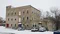 |
(#83003409) |
1300 14th Ave. 43°19′06″N 87°56′58″W / 43.318333°N 87.949444°W |
Grafton | |
| 12 | Green Bay Road Historic District | |
(#04001278) |
149-195 Green Bay Rd. 43°13′58″N 87°58′56″W / 43.232778°N 87.982222°W |
Thiensville | |
| 13 | Hamilton Historic District | |
(#76000070) |
Hamilton and Green Bay Rds. 43°17′00″N 87°58′17″W / 43.283333°N 87.971389°W |
Cedarburg | |
| 14 | Hilgen and Wittenberg Woolen Mill | 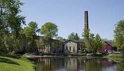 |
(#78000124) |
N70 W6340 Bridge Rd. 43°18′05″N 87°59′18″W / 43.301389°N 87.988333°W |
Cedarburg | |
| 15 | Hoffman House Hotel | 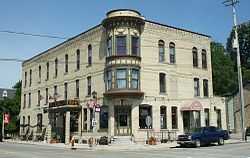 |
(#84003773) |
200 W. Grand Ave. 43°23′16″N 87°52′22″W / 43.387778°N 87.872778°W |
Port Washington | |
| 16 | Island City (schooner) Shipwreck | Upload image | (#11000810) |
9 miles southeast of Port Washington in Lake Michigan 43°14′18″N 87°50′43″W / 43.238333°N 87.845167°W |
Mequon vicinity | Great Lakes Shipwreck Sites of Wisconsin MPS |
| 17 | William F. Jahn Farmstead | 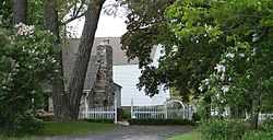 |
(#00000978) |
12112-12116 N. Wauwatosa Rd. 43°14′18″N 88°00′11″W / 43.238335°N 88.003048°W |
Mequon | |
| 18 | Main Street Historic District | 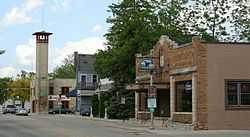 |
(#04001279) |
101 N. Main St., 105-130 S. Main St., 101 Green Bay Rd. & 107 W. Buntrock Ave. 43°13′49″N 87°59′02″W / 43.230278°N 87.983889°W |
Thiensville | |
| 19 | Mequon Town Hall and Fire Station Complex | 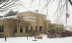 |
(#00000779) |
11333 N. Cedarburg Rd. 43°13′25″N 87°59′04″W / 43.223611°N 87.984444°W |
Mequon | 1937 Art Deco building complex |
| 20 | Milwaukee Falls Lime Company | 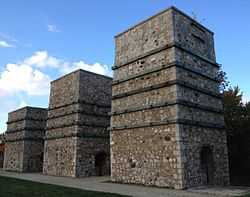 |
(#11001071) |
2020 Green Bay Rd 43°18′17″N 87°57′24″W / 43.30476°N 87.956565°W |
Grafton | |
| 21 | NIAGARA (steamer) |  |
(#96001456) |
one mile off shore 43°29′19″N 87°46′30″W / 43.488611°N 87.775°W |
Belgium | The wreck of the Niagara. Sank in 1856, taking the lives of 60 of its 170 passengers |
| 22 | Edwin J. Nieman Sr. House | Upload image | (#96000418) |
13030 N. Cedarburg Rd. 43°15′19″N 87°59′25″W / 43.255278°N 87.990278°W |
Mequon | |
| 23 | NORTHERNER Shipwreck (Schooner) | 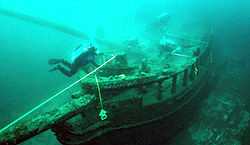 |
(#10001005) |
5 miles southeast of Port Washington Harbor in Lake Michigan 43°18′53″N 87°49′27″W / 43.314833°N 87.824167°W |
Grafton | 81-foot schooner, built in 1850, lost in 1868 off Port Ulao |
| 24 | O'Brien-Peuschel Farmstead | |
(#00001236) |
12510 N. Wauwatosa Rd. 43°14′43″N 88°00′10″W / 43.245278°N 88.002778°W |
Mequon | |
| 25 | Old Ozaukee County Courthouse | 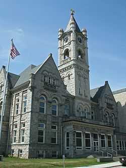 |
(#76000071) |
109 W. Main St. 43°23′18″N 87°52′16″W / 43.388333°N 87.871111°W |
Port Washington | |
| 26 | Payne Hotel | 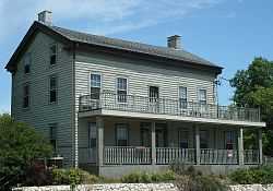 |
(#91000220) |
310 E. Green Bay Ave. 43°22′54″N 87°56′18″W / 43.381667°N 87.938333°W |
Saukville | A stagecoach inn, on Green Bay Road and Highway 33 |
| 27 | Port Washington Downtown Historic District | 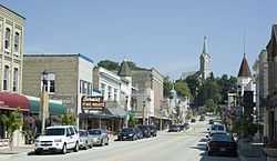 |
(#00001070) |
Roughly along N. Franklin St., from E Jackson St. to E Grand Ave. 43°23′22″N 87°52′07″W / 43.389444°N 87.868611°W |
Port Washington | |
| 28 | Port Washington Fire Engine House | 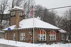 |
(#09000894) |
102 East Pier St. 43°23′24″N 87°52′15″W / 43.389892°N 87.870911°W |
Port Washington | |
| 29 | Port Washington Light Station | 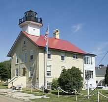 |
(#99001222) |
311 E. Johnson St. 43°23′28″N 87°52′03″W / 43.391111°N 87.8675°W |
Port Washington | Lighthouse, established 1860 |
| 30 | John Reichert Farmhouse | 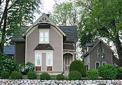 |
(#82000693) |
14053 N. Wauwatosa Rd. 43°16′25″N 88°00′15″W / 43.273611°N 88.004167°W |
Mequon | |
| 31 | St. Mary's Roman Catholic Church | 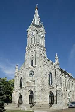 |
(#77000042) |
430 N. Johnson St. 43°23′30″N 87°52′10″W / 43.391667°N 87.869444°W |
Port Washington | Limestone Gothic Revival church |
| 32 | Stony Hill School |  |
(#76000072) |
NE of Waubeka on SR 1 43°28′46″N 87°58′48″W / 43.479444°N 87.98°W |
Waubeka | Location of the earliest formal observance of Flag Day, by schoolteacher Bernard Cigrand, in 1885. |
| 33 | TENNIE AND LAURA (Shipwreck) |  |
(#08000288) |
9 miles off shore from Port Washington Coordinates missing |
Port Washington | In 1903, the freighter Tennie & Laura sank in a storm while crossing Lake Michigan. |
| 34 | Jacob Voigt House |  |
(#00001164) |
11550 N. Wauwatosa Rd. 43°13′44″N 88°00′28″W / 43.228889°N 88.007778°W |
Mequon | |
| 35 | Washington Avenue Historic District | 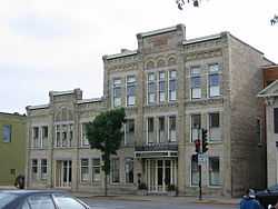 |
(#86000218) |
Roughly bounded by Elm St., Cedar Creek, Hamilton Rd., and Washington Ave. 43°18′01″N 87°59′16″W / 43.300278°N 87.987778°W |
Cedarburg | Much of downtown Cedarburg, with buildings dating to the 1850s. |
| 36 | Wayside House | 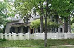 |
(#82000694) |
W61 N439 Washington Ave. 43°17′31″N 87°59′11″W / 43.291944°N 87.986389°W |
Cedarburg |
See also
| Wikimedia Commons has media related to National Register of Historic Places in Ozaukee County, Wisconsin. |
References
- ↑ "National Register of Historic Places: Weekly List Actions". National Park Service, United States Department of the Interior. Retrieved on May 1, 2015.
- ↑ Numbers represent an ordering by significant words. Various colorings, defined here, differentiate National Historic Landmarks and historic districts from other NRHP buildings, structures, sites or objects.
- ↑ The eight-digit number below each date is the number assigned to each location in the National Register Information System database, which can be viewed by clicking the number.
| ||||||||||||||||||||||||||
| |||||||||||||||||||||||||||||||||
