National Register of Historic Places listings in Okmulgee County, Oklahoma

Location of Okmulgee County in Oklahoma
This is a list of the National Register of Historic Places listings in Okmulgee County, Oklahoma.
This is intended to be a complete list of the properties and districts on the National Register of Historic Places in Okmulgee County, Oklahoma, United States. The locations of National Register properties and districts for which the latitude and longitude coordinates are included below, may be seen in a Google map.[1]
There are 19 properties and districts listed on the National Register in the county, including 1 National Historic Landmark.
- This National Park Service list is complete through NPS recent listings posted May 1, 2015.[2]
Current listings
| [3] |
Name on the Register[4] |
Image |
Date listed[5] |
Location |
City or town |
Description |
|---|
| 1 |
Creek National Capitol |
Upload image |
01966-10-15-0000October 15, 1966
(#66000632) |
6th St. and Grand Ave.
35°37′21″N 95°58′18″W / 35.6225°N 95.971667°W / 35.6225; -95.971667 (Creek National Capitol) |
Okmulgee |
|
| 2 |
Eastside Baptist Church |
Upload image |
01984-11-23-0000November 23, 1984
(#84000306) |
219 N. Osage Ave.
35°37′33″N 95°57′30″W / 35.625833°N 95.958333°W / 35.625833; -95.958333 (Eastside Baptist Church) |
Okmulgee |
|
| 3 |
First Baptist Central Church |
Upload image |
01984-11-23-0000November 23, 1984
(#84000307) |
521 N. Central Ave.
35°37′39″N 95°58′11″W / 35.6275°N 95.969722°W / 35.6275; -95.969722 (First Baptist Central Church) |
Okmulgee |
|
| 4 |
Harmon Athletic Field |
Upload image |
01999-01-25-0000January 25, 1999
(#98001588) |
North of the junction of 12th St. and Creek Ave.
35°37′05″N 95°57′51″W / 35.618056°N 95.964167°W / 35.618056; -95.964167 (Harmon Athletic Field) |
Okmulgee |
|
| 5 |
Hugh Henry House |
Upload image |
01983-08-18-0000August 18, 1983
(#83002110) |
N. 3rd St.
35°27′02″N 95°59′00″W / 35.450556°N 95.983333°W / 35.450556; -95.983333 (Hugh Henry House) |
Henryetta |
|
| 6 |
Isparhecher House and Grave |
Upload image |
01976-07-12-0000July 12, 1976
(#76001573) |
About 4 miles west of Beggs off State Highway 16
35°44′15″N 96°07′50″W / 35.7375°N 96.130556°W / 35.7375; -96.130556 (Isparhecher House and Grave) |
Beggs |
|
| 7 |
Kennedy Mansion |
Upload image |
02014-12-10-0000December 10, 2014
(#14001032) |
502 S. Okmulgee Ave.
35°37′07″N 95°58′31″W / 35.6187°N 95.9753°W / 35.6187; -95.9753 (Kennedy Mansion) |
Okmulgee |
|
| 8 |
Lake Okmulgee Dam Spillway Cascade |
Upload image |
01999-01-25-0000January 25, 1999
(#98001591) |
State Highway 56, 10 miles west of U.S. Route 62
35°37′19″N 96°03′32″W / 35.621944°N 96.058889°W / 35.621944; -96.058889 (Lake Okmulgee Dam Spillway Cascade) |
Okmulgee |
|
| 9 |
Nichols Park |
Upload image |
02006-12-06-0000December 6, 2006
(#06001115) |
1.9 miles south of the junction of Lake Rd. and Main St.
35°24′23″N 95°58′35″W / 35.406389°N 95.976389°W / 35.406389; -95.976389 (Nichols Park) |
Henryetta |
|
| 10 |
Nuyaka Mission |
Upload image |
01972-04-13-0000April 13, 1972
(#72001075) |
9 miles west of Okmulgee
35°38′59″N 96°09′46″W / 35.649722°N 96.162778°W / 35.649722; -96.162778 (Nuyaka Mission) |
Okmulgee |
|
| 11 |
Okmulgee Armory |
Upload image |
01999-01-25-0000January 25, 1999
(#98001589) |
Junction of 2nd and Alabama Sts.
35°37′37″N 95°58′35″W / 35.626944°N 95.976389°W / 35.626944; -95.976389 (Okmulgee Armory) |
Okmulgee |
|
| 12 |
Okmulgee Colored Hospital |
Upload image |
01984-06-22-0000June 22, 1984
(#84003387) |
320 N. Wood Dr.
35°38′03″N 95°57′39″W / 35.634167°N 95.960833°W / 35.634167; -95.960833 (Okmulgee Colored Hospital) |
Okmulgee |
|
| 13 |
Okmulgee County Courthouse |
Upload image |
01984-08-23-0000August 23, 1984
(#84003390) |
300 W. 7th St.
35°37′20″N 95°58′27″W / 35.622222°N 95.974167°W / 35.622222; -95.974167 (Okmulgee County Courthouse) |
Okmulgee |
|
| 14 |
Okmulgee Downtown Historic District |
|
01992-12-17-0000December 17, 1992
(#92001693) |
Roughly bounded by 4th St., Frisco Ave., 8th St., and Okmulgee Ave.
35°37′22″N 95°58′12″W / 35.622778°N 95.97°W / 35.622778; -95.97 (Okmulgee Downtown Historic District) |
Okmulgee |
|
| 15 |
Okmulgee Public Library |
Upload image |
01983-07-28-0000July 28, 1983
(#83002111) |
218 S. Okmulgee Ave.
35°37′17″N 95°58′31″W / 35.621389°N 95.975278°W / 35.621389; -95.975278 (Okmulgee Public Library) |
Okmulgee |
|
| 16 |
Okmulgee Stock Pavilion |
Upload image |
01999-01-25-0000January 25, 1999
(#98001590) |
Junction of Lagonda and Okmulgee Sts.
35°38′14″N 95°58′29″W / 35.637222°N 95.974722°W / 35.637222; -95.974722 (Okmulgee Stock Pavilion) |
Okmulgee |
|
| 17 |
St. Anthony's Catholic Church |
Upload image |
01983-07-14-0000July 14, 1983
(#83002112) |
515 S. Morton St.
35°37′06″N 95°58′20″W / 35.618333°N 95.972222°W / 35.618333; -95.972222 (St. Anthony's Catholic Church) |
Okmulgee |
|
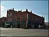
| 18 |
Severs Block |
Upload image |
01991-03-22-0000March 22, 1991
(#91000311) |
101 E. 6th St.
35°37′24″N 95°58′16″W / 35.623333°N 95.971111°W / 35.623333; -95.971111 (Severs Block) |
Okmulgee |
|
| 19 |
Wilson School |
Upload image |
01981-01-28-0000January 28, 1981
(#81000465) |
Northwest of Henryetta
35°30′28″N 96°02′06″W / 35.507778°N 96.035°W / 35.507778; -96.035 (Wilson School) |
Henryetta |
|
See also
References
- ↑ The latitude and longitude information provided in this table was derived originally from the National Register Information System, which has been found to be fairly accurate for about 99% of listings. For about 1% of NRIS original coordinates, experience has shown that one or both coordinates are typos or otherwise extremely far off; some corrections may have been made. A more subtle problem causes many locations to be off by up to 150 yards, depending on location in the country: most NRIS coordinates were derived from tracing out latitude and longitudes off of USGS topographical quadrant maps created under the North American Datum of 1927, which differs from the current, highly accurate WGS84 GPS system used by most on-line maps. Chicago is about right, but NRIS longitudes in Washington are higher by about 4.5 seconds, and are lower by about 2.0 seconds in Maine. Latitudes differ by about 1.0 second in Florida. Some locations in this table may have been corrected to current GPS standards.
- ↑ "National Register of Historic Places: Weekly List Actions". National Park Service, United States Department of the Interior. Retrieved on May 1, 2015.
- ↑ Numbers represent an ordering by significant words. Various colorings, defined here, differentiate National Historic Landmarks and historic districts from other NRHP buildings, structures, sites or objects.
- ↑ "National Register Information System". National Register of Historic Places. National Park Service. 2009-03-13.
- ↑ The eight-digit number below each date is the number assigned to each location in the National Register Information System database, which can be viewed by clicking the number.
|
|---|
| | Topics | |
|---|
| | Lists by states | |
|---|
| | Lists by insular areas | |
|---|
| | Lists by associated states | |
|---|
| | Other areas | |
|---|
|
-
 Category Category
-
 Portal Portal
-
 WikiProject WikiProject
|
|