National Register of Historic Places listings in Okaloosa County, Florida

Location of Okaloosa County in Florida
This is a list of the National Register of Historic Places listings in Okaloosa County, Florida.
This is intended to be a complete list of the properties and districts on the National Register of Historic Places in Okaloosa County, Florida, United States. The locations of National Register properties and districts for which the latitude and longitude coordinates are included below, may be seen in a Google map.[1]
There are 9 properties and districts listed on the National Register in the county, including 2 National Historic Landmarks.
- This National Park Service list is complete through NPS recent listings posted May 1, 2015.[2]
| Alachua - Baker - Bay - Bradford - Brevard - Broward - Calhoun - Charlotte - Citrus - Clay - Collier - Columbia - DeSoto - Dixie - Duval - Escambia - Flagler - Franklin - Gadsden - Gilchrist - Glades - Gulf - Hamilton - Hardee - Hendry - Hernando - Highlands - Hillsborough - Holmes - Indian River - Jackson - Jefferson - Lafayette - Lake - Lee - Leon - Levy - Liberty - Madison - Manatee - Marion - Martin - Miami-Dade - Monroe - Nassau - Okaloosa - Okeechobee - Orange - Osceola - Palm Beach - Pasco - Pinellas - Polk - Putnam - Santa Rosa - Sarasota - Seminole - St. Johns - St. Lucie - Sumter - Suwannee - Taylor - Union - Volusia - Wakulla - Walton - Washington |
Current listings
| [3] | Name on the Register[4] | Image | Date listed[5] | Location | City or town | Description |
|---|---|---|---|---|---|---|
| 1 | Camp Pinchot Historic District | |
(#98001255) |
Eglin Air Force Base, roughly east bank Garnier's Bayou, approximately ½ mile north of Fort Walton Beach 30°28′13″N 86°35′38″W / 30.470278°N 86.593889°W |
Fort Walton Beach | NRHP# 98001255 |
| 2 | Crestview Commercial Historic District | 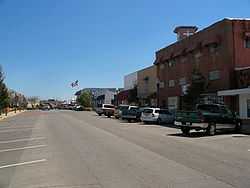 |
(#06000620) |
Roughly bounded by Industrial Drive, North Ferdon Boulevard, North Wilson Street, and James Lee Boulevard 30°45′33″N 86°34′15″W / 30.759167°N 86.570833°W |
Crestview | NRHP# 06000620 |
| 3 | Eglin Field Historic District | 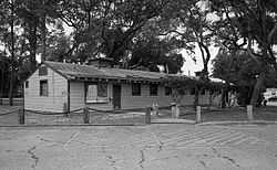 |
(#98001254) |
Eglin Air Force Base, roughly bounded by Barranca, Choctawhatchee, Fourth, and "F" Avenues 30°28′58″N 86°29′30″W / 30.482778°N 86.491667°W |
Fort Walton Beach | NRHP# 98001254 |
| 4 | Fort Walton Mound | 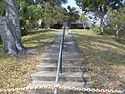 |
(#66000268) |
139 Miracle Strip Parkway Southeast 30°24′13″N 86°36′27″W / 30.403611°N 86.6075°W |
Fort Walton Beach | NRHP# 66000268 |
| 5 | GOVERNOR STONE (schooner) | 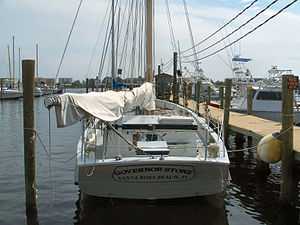 |
(#91002063) |
The Boat Marina 30°24′15″N 86°37′02″W / 30.404167°N 86.617222°W |
Fort Walton Beach | NRHP# 91002063 |
| 6 | Gulfview Hotel Historic District | 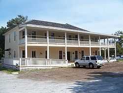 |
(#92001402) |
12 Miracle Strip Parkway Southeast 30°24′12″N 86°36′45″W / 30.403333°N 86.6125°W |
Fort Walton Beach | NRHP# 92001402 |
| 7 | McKinley Climatic Laboratory |  |
(#97001145) |
Building 440 at Eglin Air Force Base 30°28′33″N 86°30′27″W / 30.475833°N 86.5075°W |
Fort Walton Beach | NRHP# 97001145 |
| 8 | World War II JB-2 Launch Site |  |
(#96000395) |
Address Restricted |
Fort Walton Beach | NRHP# 96000394 |
| 9 | World War II JB-2 Mobile Launch Site | |
(#96000394) |
Address Restricted |
Fort Walton Beach | NRHP# 96000394 |
Former listings
| [3] | Name on the Register | Image | Date listed | Date removed | Location | City or town | Summary |
|---|---|---|---|---|---|---|---|
| 1 | Valparaiso Inn | Upload image | (#78000954) | 331 Bayshore Dr. Coordinates missing |
Valparaiso | Severely damaged in a fire March 2, 1997. Completely destroyed by a second fire October 25, 1980. |
See also
| Wikimedia Commons has media related to National Register of Historic Places in Okaloosa County, Florida. |
- List of National Historic Landmarks in Florida
- National Register of Historic Places listings in Florida
References
- ↑ The latitude and longitude information provided in this table was derived originally from the National Register Information System, which has been found to be fairly accurate for about 99% of listings. For about 1% of NRIS original coordinates, experience has shown that one or both coordinates are typos or otherwise extremely far off; some corrections may have been made. A more subtle problem causes many locations to be off by up to 150 yards, depending on location in the country: most NRIS coordinates were derived from tracing out latitude and longitudes off of USGS topographical quadrant maps created under the North American Datum of 1927, which differs from the current, highly accurate WGS84 GPS system used by most on-line maps. Chicago is about right, but NRIS longitudes in Washington are higher by about 4.5 seconds, and are lower by about 2.0 seconds in Maine. Latitudes differ by about 1.0 second in Florida. Some locations in this table may have been corrected to current GPS standards.
- ↑ "National Register of Historic Places: Weekly List Actions". National Park Service, United States Department of the Interior. Retrieved on May 1, 2015.
- ↑ 3.0 3.1 Numbers represent an ordering by significant words. Various colorings, defined here, differentiate National Historic Landmarks and historic districts from other NRHP buildings, structures, sites or objects.
- ↑ "National Register Information System". National Register of Historic Places. National Park Service. 2009-03-13.
- ↑ The eight-digit number below each date is the number assigned to each location in the National Register Information System database, which can be viewed by clicking the number.
| |||||||||||||||||||||


| |||||||||||||||||||||||||