National Register of Historic Places listings in Ocean County, New Jersey
List of the National Register of Historic Places listings in Ocean County, New Jersey
| Atlantic - Bergen - Burlington - Camden - Cape May - Cumberland - Essex - Gloucester - Hudson - Hunterdon - Mercer - Middlesex - Monmouth - Morris - Ocean - Passaic - Salem - Somerset - Sussex - Union - Warren |
This is intended to be a complete list of properties and districts listed on the National Register of Historic Places in Ocean County, New Jersey. The locations of National Register properties and districts (at least for all showing latitude and longitude coordinates below) may be seen in a Google map by clicking on "Map of all coordinates".[1]
- This National Park Service list is complete through NPS recent listings posted May 1, 2015.[2]
Current listings
| [3] | Name on the Register[4] | Image | Date listed[5] | Location | City or town | Description |
|---|---|---|---|---|---|---|
| 1 | Barnegat Light Public School | 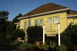 |
(#76001178) |
501 Central Ave. 39°45′35″N 74°06′20″W / 39.759722°N 74.105556°W |
Barnegat Light | |
| 2 | Barnegat Lighthouse |  |
(#71000512) |
North end of Long Beach Island, off Broadway Ave. 39°45′51″N 74°06′23″W / 39.764167°N 74.106389°W |
Barnegat Light | |
| 3 | Bartlett-Rockhill-Bartlett House | 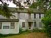 |
(#11001041) |
Bartlett Ln. 39°36′04″N 74°20′35″W / 39.601164°N 74.343167°W |
Tuckerton | |
| 4 | Bay Head Historic District | .JPG) |
(#05001566) |
Roughly bounded by Point Pleasant Beach Borough line, Atlantic Ocean, Mantoloking Borough line and Point Pleasant 40°04′18″N 74°02′51″W / 40.071667°N 74.0475°W |
Bay Head Borough | |
| 5 | Beach Haven Historic District | 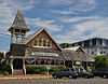 |
(#83001608) |
Roughly bounded by Bay and Atlantic Aves., Pearl and 3rd Sts.; later roughly bounded by Atlantic, Bay, 5th & Chatsworth 39°33′32″N 74°14′31″W / 39.558889°N 74.241944°W |
Beach Haven | Second set of addresses represents a boundary increase 11/19/14. |
| 6 | Capt. Amos Birdsall House | 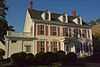 |
(#82003298) |
234 Washington St. 39°57′08″N 74°11′30″W / 39.952222°N 74.191667°W |
Toms River | |
| 7 | A.A. Brant House |  |
(#82003294) |
9 Allen St. 39°57′04″N 74°11′43″W / 39.951111°N 74.195278°W |
Toms River | |
| 8 | Cassville Crossroads Historic District |  |
(#82003291) |
Jct. of CR 571 and 528 40°06′17″N 74°23′14″W / 40.104722°N 74.387222°W |
Jackson Township | |
| 9 | Cavarly Cottage |  |
(#06000871) |
100 Stafford Ave. 39°41′50″N 74°15′19″W / 39.697222°N 74.255278°W |
Stafford Township | |
| 10 | Cedar Bridge Tavern |  |
(#13000586) |
200 Old Halfway Rd.[6] 39°47′00″N 74°21′38″W / 39.783333°N 74.360556°W |
Barnegat Township | |
| 11 | Converse Cottage | 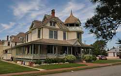 |
(#83001609) |
504 Atlantic Ave. 39°33′31″N 74°14′25″W / 39.558611°N 74.240278°W |
Beach Haven | |
| 12 | Mary Etta Cox House | 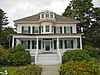 |
(#05000124) |
353 N. Main St. 39°45′13″N 74°13′26″W / 39.753611°N 74.223889°W |
Barnegat | |
| 13 | Crawford House | 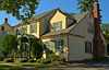 |
(#82003295) |
46 E. Water St. 39°57′03″N 74°11′46″W / 39.950833°N 74.196111°W |
Toms River | |
| 14 | Double Trouble Historic District | 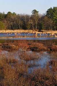 |
(#78001787) |
S of Beachwood off Garden State Pkwy. 39°53′51″N 74°13′37″W / 39.8975°N 74.226944°W |
Bayville | |
| 15 | Falkinburg Farmstead |  |
(#93000829) |
28 Westcott Ave., Ocean Township 39°47′03″N 74°11′35″W / 39.784167°N 74.193056°W |
Waretown | |
| 16 | Georgian Court |  |
(#78001788) |
Lakewood Ave. 40°05′52″N 74°13′37″W / 40.097778°N 74.226944°W |
Lakewood | |
| 17 | Capt. George W. Giberson House |  |
(#82004693) |
54 E. Water St. 39°57′03″N 74°11′46″W / 39.950833°N 74.196111°W |
Toms River | |
| 18 | Hangar No. 1, Lakehurst Naval Air Station |  |
(#68000031) |
N of Lakehurst on CR 547 40°01′44″N 74°18′59″W / 40.028889°N 74.316389°W |
Manchester Township | |
| 19 | Horner House | 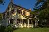 |
(#82003296) |
44 E. Water St. 39°57′04″N 74°11′47″W / 39.951111°N 74.196389°W |
Toms River | |
| 20 | Island Heights Historic District | 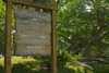 |
(#82003290) |
Roughly bounded by Toms River, Summit and River Aves. 39°56′26″N 74°08′43″W / 39.940556°N 74.145278°W |
Island Heights | |
| 21 | Little Egg Harbor Friends Meeting House | 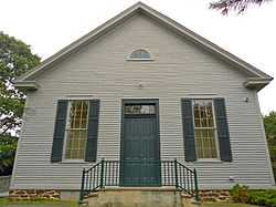 |
(#02001511) |
21 E. Main St. 39°36′12″N 74°20′29″W / 39.603333°N 74.341389°W |
Tuckerton | |
| 22 | Manahawkin Baptist Church | 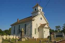 |
(#73001131) |
N. Main St. (US 9) and Lehigh Ave. 39°41′55″N 74°15′29″W / 39.698611°N 74.258056°W |
Manahawkin | |
| 23 | Manitou Park School House | 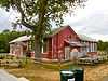 |
(#05000177) |
167 Third Ave. 39°56′48″N 74°13′03″W / 39.946667°N 74.2175°W |
Berkeley | |
| 24 | Ocean County Courthouse |  |
(#83001610) |
Washington St. 39°57′10″N 74°11′41″W / 39.952778°N 74.194722°W |
Toms River | |
| 25 | Ocean County Jail | 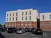 |
(#83001611) |
Sheriff St. 39°57′12″N 74°11′41″W / 39.953333°N 74.194722°W |
Toms River | |
| 26 | Orient Baptist Church | .JPG) |
(#77000902) |
NJ 88 40°04′11″N 74°07′40″W / 40.069722°N 74.127778°W |
Laurelton | |
| 27 | Stewart House | 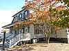 |
(#82003297) |
57 E. Water St. 39°57′03″N 74°11′46″W / 39.950833°N 74.196111°W |
Toms River | |
| 28 | Stoutenburgh-Minturn House | 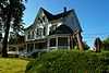 |
(#82003293) |
86 E. Water St. 39°57′02″N 74°11′36″W / 39.950556°N 74.193333°W |
Toms River | |
| 29 | Strand Theatre | 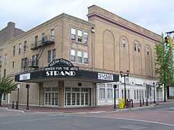 |
(#82003292) |
400 Clifton Ave. 40°05′39″N 74°12′57″W / 40.094167°N 74.215833°W |
Lakewood | |
| 30 | Torrey-Larrabee Store |  |
(#97000104) |
11 Union Ave. 40°06′09″N 74°18′34″W / 40.1025°N 74.309444°W |
Lakehurst | |
| 31 | U.S. Life Saving Station Station No. 14 |  |
(#78001789) |
S of Seaside Park on Island Beach State Park 39°56′01″N 74°04′17″W / 39.933611°N 74.071389°W |
Seaside Park | |
| 32 | Whitesbog Historic District |  |
(#88002115) |
N of SR 70 and S of Fort Dix 39°57′36″N 74°29′23″W / 39.96°N 74.489722°W |
Whiting | |
| 33 | Dr. Edward H. Williams House | 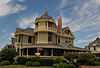 |
(#83001612) |
506 S. Atlantic Ave. 39°33′31″N 74°14′25″W / 39.558611°N 74.240278°W |
Beach Haven |
References
- ↑ The latitude and longitude information provided in this table was derived originally from the National Register Information System, which has been found to be fairly accurate for about 99% of listings. For about 1% of NRIS original coordinates, experience has shown that one or both coordinates are typos or otherwise extremely far off; some corrections may have been made. A more subtle problem causes many locations to be off by up to 150 yards, depending on location in the country: most NRIS coordinates were derived from tracing out latitude and longitudes off of USGS topographical quadrant maps created under the North American Datum of 1927, which differs from the current, highly accurate WGS84 GPS system used by most on-line maps. Chicago is about right, but NRIS longitudes in Washington are higher by about 4.5 seconds, and are lower by about 2.0 seconds in Maine. Latitudes differ by about 1.0 second in Florida. Some locations in this table may have been corrected to current GPS standards.
- ↑ "National Register of Historic Places: Weekly List Actions". National Park Service, United States Department of the Interior. Retrieved on May 1, 2015.
- ↑ Numbers represent an ordering by significant words. Various colorings, defined here, differentiate National Historic Landmarks and historic districts from other NRHP buildings, structures, sites or objects.
- ↑ "National Register Information System". National Register of Historic Places. National Park Service. 2008-04-24.
- ↑ The eight-digit number below each date is the number assigned to each location in the National Register Information System database, which can be viewed by clicking the number.
- ↑ Gall, Michael J., and Brock Giordano. Phase I and Extended Phase I Archaeological Investigation: Ocean Bridge Tavern (28-Oc-162). West Long Branch: Monmouth U, 2011-04, 1-5/1-6.
| ||||||||||||||||||||||||||
| Wikimedia Commons has media related to National Register of Historic Places in Ocean County, New Jersey. |