National Register of Historic Places listings in Nicollet County, Minnesota
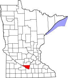
Location of Nicollet County in Minnesota
This is a list of the National Register of Historic Places listings in Nicollet County, Minnesota. It is intended to be a complete list of the properties and districts on the National Register of Historic Places in Nicollet County, Minnesota, United States. The locations of National Register properties and districts for which the latitude and longitude coordinates are included below, may be seen in an online map.[1]
There are 24 properties and districts listed on the National Register in the county. A supplementary list includes two additional sites that were formerly on the National Register.
- This National Park Service list is complete through NPS recent listings posted May 1, 2015.[2]
Current listings
| [3] | Name on the Register | Image | Date listed[4] | Location | City or town | Description |
|---|---|---|---|---|---|---|
| 1 | Broadway Bridge | 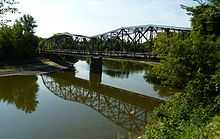 |
(#99000934) |
Minnesota Highway 99 over the Minnesota River 44°19′29″N 93°57′11″W / 44.324719°N 93.953024°W |
Oshawa Township | 1931 through truss bridge.[5] Extends into Le Sueur County. |
| 2 | Center Building-Minnesota Hospital for The Insane | Upload image | (#86002117) |
Freeman Dr. 44°18′19″N 93°58′40″W / 44.305416°N 93.977783°W |
St. Peter | 1878 Classical Revival building of Minnesota's first mental hospital, designed by Samuel Sloan on the Kirkbride Plan.[5] |
| 3 | Church of the Holy Communion-Episcopal | 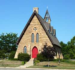 |
(#83000914) |
116 N. Minnesota Ave. 44°19′36″N 93°57′20″W / 44.326595°N 93.955525°W |
St. Peter | 1870 Gothic Revival church of Kasota limestone, designed by Henry Martyn Congdon.[5] |
| 4 | Eugene Saint Julien Cox House | 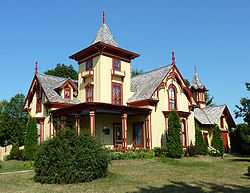 |
(#70000305) |
500 N. Washington Ave. 44°19′56″N 93°57′42″W / 44.332345°N 93.961654°W |
St. Peter | 1871 Gothic/Italianate house of St. Peter's first mayor. Now a Nicollet County Historical Society site.[6] |
| 5 | Frederick A. Donahower House | 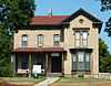 |
(#83000915) |
720 S. Minnesota Ave. 44°19′13″N 93°57′40″W / 44.320396°N 93.961061°W |
St. Peter | c. 1875 brick Italianate house with limestone trim.[5] |
| 6 | Fort Ridgely | 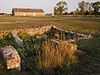 |
(#70000304) |
Minnesota Highway 4 44°27′11″N 94°44′04″W / 44.452968°N 94.734381°W |
Fairfax | 1853 U.S. Army fort built to monitor the Lower Sioux Indian Reservation. Site of the Battle of Fort Ridgely during the Dakota War of 1862. Now a state park and historic site.[7] |
| 7 | Fort Ridgely State Park CCC/Rustic Style Historic Resources | |
(#89001668) |
Off County Highway 30 northwest of New Ulm 44°27′11″N 94°43′51″W / 44.45301°N 94.730773°W |
New Ulm | 27 Rustic Style park structures built by the Civilian Conservation Corps in the mid-1930s.[8] |
| 8 | Alexander Harkin Store |  |
(#73000989) |
County highway 21 44°23′13″N 94°35′56″W / 44.386944°N 94.598889°W |
New Ulm | 1871 rural store and post office, now a Minnesota Historical Society museum with much of the original inventory intact.[9] |
| 9 | John A. Johnson House | 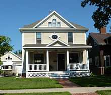 |
(#83000916) |
418 N. 3rd St. 44°19′47″N 93°57′17″W / 44.329824°N 93.954642°W |
St. Peter | 1905 frame house of three-term governor John Albert Johnson.[5] |
| 10 | Sarah and Thomas Montgomery House | 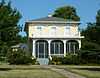 |
(#00001509) |
408 Washington Ave. S 44°19′32″N 93°57′51″W / 44.325523°N 93.964176°W |
St. Peter | 1874 brick Italianate house.[5] |
| 11 | Nicollet County Bank | 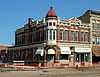 |
(#83000917) |
224 S. Minnesota Ave. 44°19′28″N 93°57′27″W / 44.324409°N 93.957379°W |
St. Peter | 1887 brick Queen Anne bank with Kasota limestone trim.[5] Also a contributing property to the St. Peter Commercial Historic District.[10] |
| 12 | Nicollet County Courthouse and Jail | 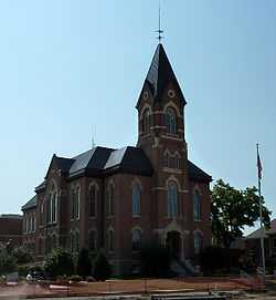 |
(#02000939) |
501 S, Minnesota Ave. 44°19′18″N 93°57′31″W / 44.321751°N 93.958597°W |
St. Peter | 1881 brick Romanesque Revival courthouse designed by Edward Bassford, and 1907 brick Queen Anne jailhouse.[5] |
| 13 | Nicollet Hotel | 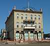 |
(#75000998) |
Minnesota Ave. at Park Row 44°19′31″N 93°57′24″W / 44.325285°N 93.956749°W |
St. Peter | 1874 brick Italianate hotel designed by Edward Bassford.[5] |
| 14 | Norseland General Store | 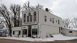 |
(#83000918) |
Minnesota Highway 22 44°24′43″N 94°06′56″W / 44.411892°N 94.115592°W |
Lake Prairie Township | c. 1900 rural store.[5] |
| 15 | North Mankato Public School | 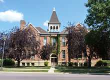 |
(#83000919) |
442 Belgrade Ave. 44°10′13″N 94°00′48″W / 44.170351°N 94.013204°W |
North Mankato | 1890 brick Queen Anne school with a 1904 addition.[5] |
| 16 | Old Main, Gustavus Adolphus College | 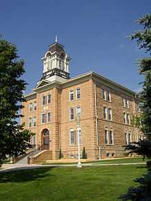 |
(#76001065) |
Gustavus Adolphus College campus 44°19′23″N 93°58′14″W / 44.322954°N 93.970648°W |
St. Peter | 1876 Italianate campus building of Kasota limestone, designed by Edward Bassford.[5] |
| 17 | Emily and Stephen Schumacher House | 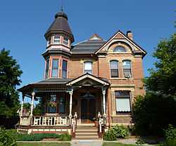 |
(#00001507) |
202 3rd St., N. 44°19′40″N 93°57′23″W / 44.327737°N 93.956477°W |
St. Peter | 1888 brick Queen Anne house.[5] |
| 18 | St. Peter Armory | 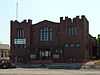 |
(#96001558) |
419 S. Minnesota Ave. 44°19′21″N 93°57′29″W / 44.322595°N 93.958015°W |
St. Peter | 1913 brick Gothic Revival armory with Kasota limestone trim, first state-owned National Guard armory in Minnesota.[5] |
| 19 | St. Peter Carnegie Library | 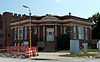 |
(#83000920) |
429 S. Minnesota Ave. 44°19′21″N 93°57′29″W / 44.322486°N 93.958151°W |
St. Peter | 1904 Classical Revival Carnegie library.[5] |
| 20 | St. Peter Commercial Historic District | |
(#00001610) |
Minnesota Ave. between Broadway and Grace Sts. 44°19′28″N 93°57′24″W / 44.324551°N 93.956797°W |
St. Peter | Late-19th and early-20th-century commercial buildings, largely of brick with stone trim.[5] |
| 21 | William E. Stewart House | 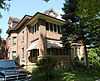 |
(#84000223) |
733 Range St. 44°10′30″N 94°00′32″W / 44.174943°N 94.008948°W |
North Mankato | 1910 brick house and outbuildings built adjacent to owner's brickyard.[5] |
| 22 | Henry A. Swift House | 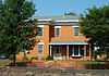 |
(#83000921) |
820 S. Minnesota Ave. 44°19′10″N 93°57′42″W / 44.319398°N 93.961769°W |
St. Peter | 1858 Federal/Italianate house of politician Henry Adoniram Swift.[5] |
| 23 | Traverse des Sioux | 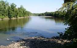 |
(#73000990) |
2 miles north of St. Peter off U.S. Route 169 44°21′23″N 93°57′15″W / 44.356402°N 93.954265°W |
St. Peter | An important river crossing from prehistory into the fur trade era, and site of U.S.–Dakota negotiations for the 1851 Treaty of Traverse des Sioux. Now a state and Nicollet County Historical Society site.[11] |
| 24 | Union Presbyterian Church | 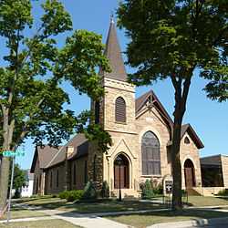 |
(#83000922) |
311 W. Locust St. 44°19′15″N 93°57′45″W / 44.320844°N 93.962478°W |
St. Peter | 1872 Gothic Revival church of Kasota limestone.[5] |
Former listings
| [3] | Name on the Register | Image | Date listed | Date removed | Location | City or town | Summary |
|---|---|---|---|---|---|---|---|
| 1 | Bridge No. 6422-Saint Peter | Upload image | (#99000933) | MN 99 over Washington Avenue |
St. Peter | 1948 deck girder bridge of cantilevered concrete, first of its kind in Minnesota.[5] Demolished in 2001.[12] | |
| 2 | St. Peter Central School | 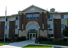 |
(#80002092) | 300 S. 5th St. 44°19′32″N 93°57′42″W / 44.325556°N 93.961667°W |
St. Peter | Destroyed in the 1998 Comfrey – St. Peter tornado outbreak. Original façade worked into Central Square Apartments on the same site. |
See also
- List of National Historic Landmarks in Minnesota
- National Register of Historic Places listings in Minnesota
References
- ↑ The latitude and longitude information provided in this table was derived originally from the National Register Information System, which has been found to be fairly accurate for about 99% of listings. For about 1% of NRIS original coordinates, experience has shown that one or both coordinates are typos or otherwise extremely far off; some corrections may have been made. A more subtle problem causes many locations to be off by up to 150 yards, depending on location in the country: most NRIS coordinates were derived from tracing out latitude and longitudes off of USGS topographical quadrant maps created under the North American Datum of 1927, which differs from the current, highly accurate WGS84 GPS system used by most on-line maps. Chicago is about right, but NRIS longitudes in Washington are higher by about 4.5 seconds, and are lower by about 2.0 seconds in Maine. Latitudes differ by about 1.0 second in Florida. Some locations in this table may have been corrected to current GPS standards.
- ↑ "National Register of Historic Places: Weekly List Actions". National Park Service, United States Department of the Interior. Retrieved on May 1, 2015.
- ↑ 3.0 3.1 Numbers represent an ordering by significant words. Various colorings, defined here, differentiate National Historic Landmarks and historic districts from other NRHP buildings, structures, sites or objects.
- ↑ The eight-digit number below each date is the number assigned to each location in the National Register Information System database, which can be viewed by clicking the number.
- ↑ 5.0 5.1 5.2 5.3 5.4 5.5 5.6 5.7 5.8 5.9 5.10 5.11 5.12 5.13 5.14 5.15 5.16 5.17 5.18 5.19 Nord, Mary Ann (2003). The National Register of Historic Places in Minnesota. Minnesota Historical Society. ISBN 0-87351-448-3.
- ↑ Hanson, Krista Finstad (2007). Minnesota Open House: A Guide to Historic House Museums. St. Paul, Minn.: Minnesota Historical Society Press. ISBN 978-0-87351-577-1.
- ↑ "Fort Ridgely". Minnesota Historical Society. Retrieved 2012-09-18.
- ↑ "Fort Ridgely State Park". Rustic Style Resources in Minnesota State Parks. Minnesota Historical Society. Retrieved 2012-08-26.
- ↑ "Harkin Store". Minnesota Historical Society. Retrieved 2012-09-18.
- ↑ "St. Peter Commercial Historic District". Minnesota Historical Society. 2009. Retrieved 2013-03-01.
- ↑ "Traverse des Sioux". Minnesota Historical Society. Retrieved 2012-09-18.
- ↑ "Changes to the National Register of Historic Places in Minnesota, 2003-2010". Minnesota State Historic Preservation Office. 2011-02-01. Retrieved 2013-03-01.
External links
| Wikimedia Commons has media related to National Register of Historic Places in Nicollet County, Minnesota. |
- Minnesota National Register Properties Database—Minnesota Historical Society
| ||||||||||||||||||||||||||
| |||||||||||||||||||||||||||||