National Register of Historic Places listings in Nevada County, Arkansas
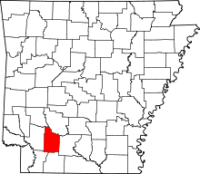
Location of Nevada County in Arkansas
This is a list of the National Register of Historic Places listings in Nevada County, Arkansas.
This is intended to be a complete list of the properties and districts on the National Register of Historic Places in Nevada County, Arkansas, United States. The locations of National Register properties and districts for which the latitude and longitude coordinates are included below, may be seen in a Google map.[1]
There are 17 properties and districts listed on the National Register in the county, including 2 National Historic Landmarks.
Contents: Counties in Arkansas
|
|
- This National Park Service list is complete through NPS recent listings posted May 1, 2015.[2]
Current listings
| [3] |
Name on the Register[4] |
Image |
Date listed[5] |
Location |
City or town |
Description |
|---|
| 1 |
Allen Tire Company and Gas Station |
Upload image |
02001-05-25-0000May 25, 2001
(#01000523) |
228 1st St., SW.
33°48′05″N 93°22′56″W / 33.801389°N 93.382222°W / 33.801389; -93.382222 (Allen Tire Company and Gas Station) |
Prescott |
|
| 2 |
Camden to Washington Road-Rosston Segment |
Upload image |
02009-01-29-0000January 29, 2009
(#08001374) |
County Road 10
33°35′30″N 93°10′08″W / 33.5917°N 93.1690°W / 33.5917; -93.1690 (Camden to Washington Road-Rosston Segment) |
Rosston |
|
| 3 |
Carolina Methodist Church |
Upload image |
01991-01-03-0000January 3, 1991
(#90001947) |
County Road 10 east of its junction with Kirk Rd. in the Poison Springs State Forest
33°35′31″N 93°10′07″W / 33.591944°N 93.168611°W / 33.591944; -93.168611 (Carolina Methodist Church) |
Rosston |
|
| 4 |
De Ann Cemetery Historic Section |
Upload image |
02005-06-01-0000June 1, 2005
(#05000498) |
½ mile west of the junction of U.S. Route 371 and Highway 19
33°48′38″N 93°23′32″W / 33.810556°N 93.392222°W / 33.810556; -93.392222 (De Ann Cemetery Historic Section) |
Prescott |
|
| 5 |
Elkins' Ferry |
Upload image |
01994-04-19-0000April 19, 1994
(#94001182) |
Both banks of the Little Missouri River, about 10 miles north of Prescott
33°56′09″N 93°21′12″W / 33.935833°N 93.353333°W / 33.935833; -93.353333 (Elkins' Ferry) |
Prescott |
Site of the Civil War Battle of Elkin's Ferry; one of the Camden Expedition Sites, a National Historic Landmark District consisting of sites in several counties; Elkin's Ferry extends into Clark County
|
| 6 |
Emmet Methodist Church |
Upload image |
02009-09-23-0000September 23, 2009
(#09000742) |
209 S. Walnut
33°43′40″N 93°28′19″W / 33.727803°N 93.472064°W / 33.727803; -93.472064 (Emmet Methodist Church) |
Emmet |
|
| 7 |
Ephesus Cemetery |
Upload image |
02009-01-22-0000January 22, 2009
(#08001340) |
¼ mile north of Emmet on U.S. Route 67
33°44′26″N 93°28′02″W / 33.7406°N 93.4672°W / 33.7406; -93.4672 (Ephesus Cemetery) |
Emmet |
|
| 8 |
Henry McKenzie House |
Upload image |
01998-09-03-0000September 3, 1998
(#98001128) |
324 E. Main
33°47′59″N 93°22′41″W / 33.799722°N 93.378056°W / 33.799722; -93.378056 (Henry McKenzie House) |
Prescott |
|
| 9 |
D.L. McRae House |
Upload image |
01982-12-22-0000December 22, 1982
(#82000869) |
424 E. Main St.
33°47′57″N 93°22′38″W / 33.799167°N 93.377222°W / 33.799167; -93.377222 (D.L. McRae House) |
Prescott |
|
| 10 |
T.C. McRae House |
Upload image |
01982-12-22-0000December 22, 1982
(#82000870) |
506 E. Elm St.
33°47′52″N 93°22′40″W / 33.797778°N 93.377778°W / 33.797778; -93.377778 (T.C. McRae House) |
Prescott |
|
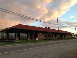
| 11 |
Missouri Pacific Depot |
|
01978-11-17-0000November 17, 1978
(#78000614) |
300 W. 1st St., N.
33°47′45″N 93°23′22″W / 33.795833°N 93.389444°W / 33.795833; -93.389444 (Missouri Pacific Depot) |
Prescott |
|
| 12 |
Moscow Methodist Church and Cemetery |
Upload image |
02006-09-20-0000September 20, 2006
(#06000826) |
Junction of Highways Highway 23 and Highway 260
33°46′42″N 93°22′00″W / 33.778333°N 93.366667°W / 33.778333; -93.366667 (Moscow Methodist Church and Cemetery) |
Prescott |
|
| 13 |
Prairie De Ann Battlefield |
Upload image |
01974-03-22-0000March 22, 1974
(#74000481) |
North and south of Highway 24 and southwest of Prescott
33°49′31″N 93°25′54″W / 33.825278°N 93.431667°W / 33.825278; -93.431667 (Prairie De Ann Battlefield) |
Prescott |
One of the Camden Expedition Sites, a National Historic Landmark consisting of sites in several counties
|
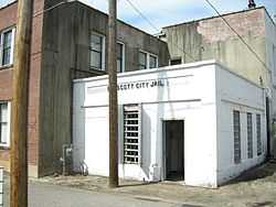
| 14 |
Prescott City Jail |
|
02005-09-28-0000September 28, 2005
(#05001077) |
Alley behind City Hall at 118 W. Elm St.
33°48′15″N 93°22′56″W / 33.804167°N 93.382222°W / 33.804167; -93.382222 (Prescott City Jail) |
Prescott |
|
| 15 |
Prescott Commercial Historic District |
Upload image |
02008-12-24-0000December 24, 2008
(#08000818) |
Roughly bounded by E. 3rd St., Walnut St., W. 3rd St., and Pine St.
33°48′06″N 93°22′54″W / 33.8018°N 93.3818°W / 33.8018; -93.3818 (Prescott Commercial Historic District) |
Prescott |
|
| 16 |
US 67 Bridge over Little Missouri River |
Upload image |
02007-01-24-0000January 24, 2007
(#06001271) |
U.S. Route 67
33°52′48″N 93°18′16″W / 33.88°N 93.304444°W / 33.88; -93.304444 (US 67 Bridge over Little Missouri River) |
Prescott |
Extends into Clark County
|
| 17 |
Wortham Gymnasium |
Upload image |
01990-04-19-0000April 19, 1990
(#90000667) |
Highway 200
33°35′55″N 93°14′19″W / 33.598611°N 93.238611°W / 33.598611; -93.238611 (Wortham Gymnasium) |
Oak Grove |
|
Former listings
| [3] |
Name on the Register |
Image |
Date listed | Date removed |
Location |
City or town |
Summary |
|---|
| 1 |
Bemis Florist Shop |
Upload image |
01982-12-22-0000December 22, 1982
(#82000868) | 01999-09-17-0000September 17, 1999 |
117 E. Second
|
Prescott |
|
See also
References
- ↑ The latitude and longitude information provided in this table was derived originally from the National Register Information System, which has been found to be fairly accurate for about 99% of listings. For about 1% of NRIS original coordinates, experience has shown that one or both coordinates are typos or otherwise extremely far off; some corrections may have been made. A more subtle problem causes many locations to be off by up to 150 yards, depending on location in the country: most NRIS coordinates were derived from tracing out latitude and longitudes off of USGS topographical quadrant maps created under the North American Datum of 1927, which differs from the current, highly accurate WGS84 GPS system used by most on-line maps. Chicago is about right, but NRIS longitudes in Washington are higher by about 4.5 seconds, and are lower by about 2.0 seconds in Maine. Latitudes differ by about 1.0 second in Florida. Some locations in this table may have been corrected to current GPS standards.
- ↑ "National Register of Historic Places: Weekly List Actions". National Park Service, United States Department of the Interior. Retrieved on May 1, 2015.
- ↑ 3.0 3.1 Numbers represent an ordering by significant words. Various colorings, defined here, differentiate National Historic Landmarks and historic districts from other NRHP buildings, structures, sites or objects.
- ↑ "National Register Information System". National Register of Historic Places. National Park Service. 2009-03-13.
- ↑ The eight-digit number below each date is the number assigned to each location in the National Register Information System database, which can be viewed by clicking the number.
|
|---|
| | Topics | |
|---|
| | Lists by states | |
|---|
| | Lists by insular areas | |
|---|
| | Lists by associated states | |
|---|
| | Other areas | |
|---|
|
-
 Category Category
-
 Portal Portal
-
 WikiProject WikiProject
|
|