National Register of Historic Places listings in Nassau County, Florida
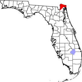
Location of Nassau County in Florida
This is a list of the National Register of Historic Places listings in Nassau County, Florida.
This is intended to be a complete list of the properties and districts on the National Register of Historic Places in Nassau County, Florida, United States. The locations of National Register properties and districts for which the latitude and longitude coordinates are included below, may be seen in a Google map.[1]
There are 14 properties and districts listed on the National Register in the county.
- This National Park Service list is complete through NPS recent listings posted May 1, 2015.[2]
| Alachua - Baker - Bay - Bradford - Brevard - Broward - Calhoun - Charlotte - Citrus - Clay - Collier - Columbia - DeSoto - Dixie - Duval - Escambia - Flagler - Franklin - Gadsden - Gilchrist - Glades - Gulf - Hamilton - Hardee - Hendry - Hernando - Highlands - Hillsborough - Holmes - Indian River - Jackson - Jefferson - Lafayette - Lake - Lee - Leon - Levy - Liberty - Madison - Manatee - Marion - Martin - Miami-Dade - Monroe - Nassau - Okaloosa - Okeechobee - Orange - Osceola - Palm Beach - Pasco - Pinellas - Polk - Putnam - Santa Rosa - Sarasota - Seminole - St. Johns - St. Lucie - Sumter - Suwannee - Taylor - Union - Volusia - Wakulla - Walton - Washington |
Current listings
| [3] | Name on the Register[4] | Image | Date listed[5] | Location | City or town | Description |
|---|---|---|---|---|---|---|
| 1 | Amelia Island Lighthouse | 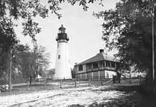 |
(#03000004) |
215½ Lighthouse Circle 30°40′23″N 81°26′33″W / 30.673056°N 81.4425°W |
Fernandina Beach | NRHP# 03000004, Part of the Florida's Historic Lighthouses MPS |
| 2 | American Beach Historic District | 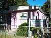 |
(#01001532) |
Roughly bounded by Gregg, Lewis, Leonard, Main, and James Streets, and Ocean Boulevard 30°34′24″N 81°26′46″W / 30.573333°N 81.446111°W |
American Beach | NRHP# 01001532 |
| 3 | Bailey House | 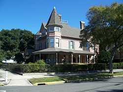 |
(#73000591) |
28 South 7th Street 30°40′09″N 81°27′37″W / 30.669167°N 81.460278°W |
Fernandina Beach | NRHP# 73000591 |
| 4 | Ervin's Rest | 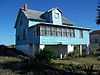 |
(#98000376) |
5448 Gregg Street 30°34′30″N 81°26′40″W / 30.575°N 81.444444°W |
American Beach | NRHP# 98000376 |
| 5 | Fairbanks House | 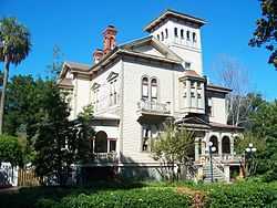 |
(#73000592) |
227 South 7th Street 30°40′10″N 81°27′46″W / 30.669444°N 81.462778°W |
Fernandina Beach | NRHP# 73000592 |
| 6 | Fernandina Beach Historic District | 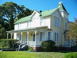 |
(#73000593) |
Roughly bounded by North 9th Street, Broome, Ash, South 5th Street, Date, and South 8th Street; also roughly bounded by Sixth, Broome, North Third, and Escambia Streets, Seventh and Date Streets, and Ash 30°40′13″N 81°27′42″W / 30.670278°N 81.461667°W |
Fernandina Beach | Second set of boundaries represents a boundary increase of April 20, 1987; NRHP# 73000593 and 87000195 |
| 7 | Fort Clinch |  |
(#72000343) |
3 miles north of Fernandina Beach on State Road A1A 30°42′17″N 81°27′18″W / 30.704722°N 81.455°W |
Fernandina Beach | NRHP# 72000343 |
| 8 | Hippard House | 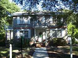 |
(#01001087) |
5406 Ervin Street 30°34′32″N 81°26′50″W / 30.575556°N 81.447222°W |
American Beach | NRHP# 01001087 |
| 9 | Merrick-Simmons House | 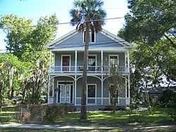 |
(#83001431) |
102 South 10th Street 30°40′08″N 81°27′26″W / 30.668889°N 81.457222°W |
Fernandina Beach | NRHP# 83001431 |
| 10 | Mount Olive Missionary Baptist Church | 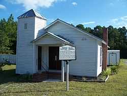 |
(#98001099) |
State Road 107 30°34′42″N 81°31′08″W / 30.578333°N 81.518889°W |
Nassauville | NRHP# 98001099 |
| 11 | Nassau County Jail |  |
(#09000927) |
233 South 3rd Street 30°40′04″N 81°27′49″W / 30.667778°N 81.463611°W |
Fernandina Beach | NRHP# 09000927 |
| 12 | Original Town of Fernandina Historic Site |  |
(#86003685) |
Roughly bounded by Towngate Street, the city cemetery, and Nassau, Marine, and Ladies Streets 30°41′20″N 81°27′16″W / 30.688889°N 81.454444°W |
Fernandina Beach | NRHP# 86003685 |
| 13 | John Denham Palmer House | 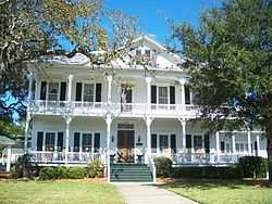 |
(#86001453) |
1305 Atlantic Avenue 30°40′11″N 81°27′11″W / 30.669722°N 81.453056°W |
Fernandina Beach | NRHP# 86001453 |
| 14 | Tabby House | 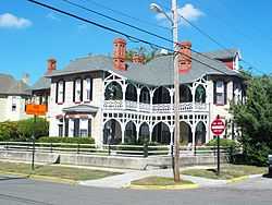 |
(#73000594) |
27 South 7th Street 30°40′08″N 81°27′36″W / 30.668889°N 81.46°W |
Fernandina Beach | NRHP# 73000594 |
See also
| Wikimedia Commons has media related to National Register of Historic Places in Nassau County, Florida. |
- List of National Historic Landmarks in Florida
- National Register of Historic Places listings in Florida
References
- ↑ The latitude and longitude information provided in this table was derived originally from the National Register Information System, which has been found to be fairly accurate for about 99% of listings. For about 1% of NRIS original coordinates, experience has shown that one or both coordinates are typos or otherwise extremely far off; some corrections may have been made. A more subtle problem causes many locations to be off by up to 150 yards, depending on location in the country: most NRIS coordinates were derived from tracing out latitude and longitudes off of USGS topographical quadrant maps created under the North American Datum of 1927, which differs from the current, highly accurate WGS84 GPS system used by most on-line maps. Chicago is about right, but NRIS longitudes in Washington are higher by about 4.5 seconds, and are lower by about 2.0 seconds in Maine. Latitudes differ by about 1.0 second in Florida. Some locations in this table may have been corrected to current GPS standards.
- ↑ "National Register of Historic Places: Weekly List Actions". National Park Service, United States Department of the Interior. Retrieved on May 1, 2015.
- ↑ Numbers represent an ordering by significant words. Various colorings, defined here, differentiate National Historic Landmarks and historic districts from other NRHP buildings, structures, sites or objects.
- ↑ "National Register Information System". National Register of Historic Places. National Park Service. 2009-03-13.
- ↑ The eight-digit number below each date is the number assigned to each location in the National Register Information System database, which can be viewed by clicking the number.
| |||||||||||||||||||||


| |||||||||||||||||||||||||