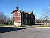
| [3] |
Name on the Register[4] |
Image |
Date listed[5] |
Location |
City or town |
Description |
|---|
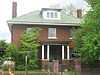
| 1 |
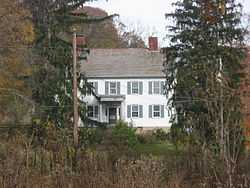
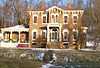
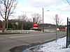
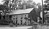
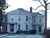
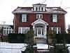
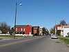
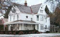
Adams-Gray House |
|
01979-12-05-0000December 5, 1979
(#79001797) |
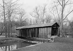
Southeast of Trinway on Tobacco Hill Rd.
40°09′31″N 81°56′54″W / 40.158611°N 81.948333°W / 40.158611; -81.948333 (Adams-Gray House) |
Cass Township |
Extends into Virginia Township in Coshocton County
|
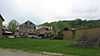
| 2 |
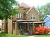
George W. Adams House |
Upload image |
01979-11-29-0000November 29, 1979
(#79001912) |
South of Trinway on Bottom Rd.
40°07′54″N 82°00′57″W / 40.131667°N 82.015833°W / 40.131667; -82.015833 (George W. Adams House) |
Cass Township |
|
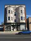
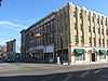
| 3 |
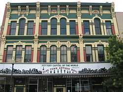
Adena Court Apartments |
|
01980-09-27-0000September 27, 1980
(#80003190) |
41 S. 4th St.
39°56′22″N 82°00′29″W / 39.939444°N 82.008056°W / 39.939444; -82.008056 (Adena Court Apartments) |
Zanesville |
|
| 4 |
Alameda Apartments |
|
01982-06-17-0000June 17, 1982
(#82003623) |
7th St.
39°56′40″N 82°00′15″W / 39.944444°N 82.004167°W / 39.944444; -82.004167 (Alameda Apartments) |
Zanesville |
|
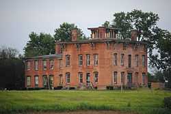
| 5 |
Arlington Hotel |
|
01982-12-16-0000December 16, 1982
(#82001482) |
722 Main St.
39°56′24″N 82°00′14″W / 39.94°N 82.003889°W / 39.94; -82.003889 (Arlington Hotel) |
Zanesville |
Destroyed
|
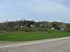
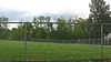
| 6 |
Baughman Memorial Park |
Upload image |
01979-08-27-0000August 27, 1979
(#79001909) |
West of Frazeysburg on State Route 586
40°06′41″N 82°10′37″W / 40.111389°N 82.176944°W / 40.111389; -82.176944 (Baughman Memorial Park) |
Jackson Township |
|
| 7 |
Belt Line and New York Central Freight House |
|
01983-03-24-0000March 24, 1983
(#83002015) |
3rd and Market Sts.
39°56′32″N 82°00′33″W / 39.942153°N 82.009097°W / 39.942153; -82.009097 (Belt Line and New York Central Freight House) |
Zanesville |
|
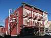
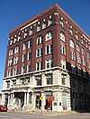
| 8 |
Black-Elliott Block |
|
01979-05-08-0000May 8, 1979
(#79001914) |
525 Main St.
39°56′25″N 82°00′21″W / 39.940278°N 82.005833°W / 39.940278; -82.005833 (Black-Elliott Block) |
Zanesville |
|
| 9 |
Blocksom-Rolls House |
|
01979-02-21-0000February 21, 1979
(#79001915) |
960 Eastman St.
39°56′34″N 81°59′59″W / 39.942778°N 81.999722°W / 39.942778; -81.999722 (Blocksom-Rolls House) |
Zanesville |
|
| 10 |
Charles Brendel House |
|
01980-11-25-0000November 25, 1980
(#80003191) |
427 Wayne Ave.
39°56′02″N 82°00′10″W / 39.933889°N 82.002778°W / 39.933889; -82.002778 (Charles Brendel House) |
Zanesville |
|
| 11 |
Brighton-Dryden Historic District |
|
01982-06-01-0000June 1, 1982
(#82003624) |
Dryden Rd., Brighton Boulevard, and Lexington and Stanberry Aves.
39°55′47″N 82°01′21″W / 39.929722°N 82.0225°W / 39.929722; -82.0225 (Brighton-Dryden Historic District) |
Zanesville |
|
| 12 |
Buckingham-Petty House |
Upload image |
01980-08-11-0000August 11, 1980
(#80003182) |
Mound Rd.
39°52′51″N 81°54′49″W / 39.880833°N 81.913611°W / 39.880833; -81.913611 (Buckingham-Petty House) |
Wayne Township |
|
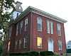
| 13 |
Nicholas Christman House |
|
01978-05-22-0000May 22, 1978
(#78002159) |
532 Wayne Ave.
39°55′51″N 82°00′05″W / 39.930833°N 82.001389°W / 39.930833; -82.001389 (Nicholas Christman House) |
Zanesville |
|
| 14 |
Howard Chandler Christy Art Studio |
|
02011-06-15-0000June 15, 2011
(#11000368) |
6020 S. River Rd., north of Blue Rock
39°51′22″N 81°53′52″W / 39.856111°N 81.897778°W / 39.856111; -81.897778 (Howard Chandler Christy Art Studio) |
Wayne Township |
1908-1909 estate of Howard Chandler Christy; also known as The Barracks[6]
|
| 15 |
Clossman Hardware Store |
|
01980-11-25-0000November 25, 1980
(#80003192) |
621-623 Main St.
39°56′24″N 82°00′18″W / 39.94°N 82.005°W / 39.94; -82.005 (Clossman Hardware Store) |
Zanesville |
|
| 16 |
Crescent Hill |
Upload image |
01986-01-09-0000January 9, 1986
(#86000034) |
44 W. 5th St.
40°07′23″N 82°00′57″W / 40.122972°N 82.015833°W / 40.122972; -82.015833 (Crescent Hill) |
Dresden |
|
| 17 |
William Denison House |
Upload image |
01982-04-29-0000April 29, 1982
(#82003620) |
7115 Adamsville Rd. (State Route 93), south of Adamsville
40°03′08″N 81°53′35″W / 40.052222°N 81.893056°W / 40.052222; -81.893056 (William Denison House) |
Salem Township |
|
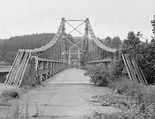
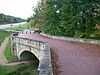
| 18 |
Dresden Suspension Bridge |
|
01978-12-01-0000December 1, 1978
(#78002153) |
State Routes 208 and 666
40°07′14″N 82°00′01″W / 40.120556°N 82.000278°W / 40.120556; -82.000278 (Dresden Suspension Bridge) |
Dresden and Madison Township |
|
| 19 |
Abram Emery House |
|
01978-12-06-0000December 6, 1978
(#78002160) |
413 Pershing Rd.
39°55′31″N 82°00′43″W / 39.925278°N 82.011944°W / 39.925278; -82.011944 (Abram Emery House) |
Zanesville |
Destroyed
|
| 20 |
Factory Site |
|
01980-03-11-0000March 11, 1980
(#80003183) |
Along Moxahala Creek in Ironspot
39°49′13″N 82°03′51″W / 39.820278°N 82.064167°W / 39.820278; -82.064167 (Factory Site) |
Newton Township |
|
| 21 |
Fairmont Avenue Historic District |
|
01982-11-30-0000November 30, 1982
(#82001483) |
Fairmont Ave.
39°57′31″N 82°00′47″W / 39.958611°N 82.013056°W / 39.958611; -82.013056 (Fairmont Avenue Historic District) |
Zanesville |
|
| 22 |
Five Mile House |
Upload image |
01977-04-11-0000April 11, 1977
(#77001081) |
South of Zanesville off U.S. Route 22
39°52′55″N 82°03′32″W / 39.881944°N 82.058889°W / 39.881944; -82.058889 (Five Mile House) |
Newton Township |
|
| 23 |
James Galigher House |
Upload image |
01979-02-22-0000February 22, 1979
(#79001916) |
South of Zanesville on S. River Rd.
39°53′57″N 81°59′58″W / 39.899167°N 81.999444°W / 39.899167; -81.999444 (James Galigher House) |
Wayne Township |
|
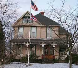
| 24 |
Ernest J. Gorsuch House |
|
01980-03-11-0000March 11, 1980
(#80003193) |
1869 Norwood Boulevard
39°57′47″N 82°00′19″W / 39.963056°N 82.005278°W / 39.963056; -82.005278 (Ernest J. Gorsuch House) |
Zanesville |
|
| 25 |
Ralph Hardesty Stone House |
|
01980-03-11-0000March 11, 1980
(#80003184) |
Main St.
39°59′08″N 81°47′24″W / 39.985556°N 81.79°W / 39.985556; -81.79 (Ralph Hardesty Stone House) |
Norwich |
|
| 26 |
William Rainey Harper Log House |
|
01978-04-06-0000April 6, 1978
(#78002154) |
E. Main St.
39°59′38″N 81°44′05″W / 39.993889°N 81.734722°W / 39.993889; -81.734722 (William Rainey Harper Log House) |
New Concord |
|
| 27 |
Harper-Cosgrave Block |
|
01980-01-03-0000January 3, 1980
(#80003195) |
62 N. 3rd St.[7]
39°56′30″N 82°00′32″W / 39.9417°N 82.0089°W / 39.9417; -82.0089 (Harper-Cosgrave Block) |
Zanesville |
|
| 28 |
William B. Harris House |
|
01978-05-22-0000May 22, 1978
(#78002161) |
1320 Newman Dr.
39°56′24″N 81°59′28″W / 39.94°N 81.991111°W / 39.94; -81.991111 (William B. Harris House) |
Zanesville |
|
| 29 |
Headley Inn, Smith House and Farm |
|
01978-04-26-0000April 26, 1978
(#78002162) |
5255 West Pike
39°57′14″N 82°05′39″W / 39.953889°N 82.094167°W / 39.953889; -82.094167 (Headley Inn, Smith House and Farm) |
Falls Township |
|
| 30 |
James Hunter Stone House |
Upload image |
01980-01-03-0000January 3, 1980
(#80003181) |
East of Adamsville on Mercer Rd.
40°05′35″N 81°48′15″W / 40.093183°N 81.804199°W / 40.093183; -81.804199 (James Hunter Stone House) |
Monroe Township |
|
| 31 |
Johnston-Crossland House |
|
01982-03-15-0000March 15, 1982
(#82003625) |
N. 7th St.
39°56′36″N 82°00′15″W / 39.943333°N 82.004167°W / 39.943333; -82.004167 (Johnston-Crossland House) |
Zanesville |
Destroyed
|
| 32 |
George and Edward Kearns Houses |
|
01979-02-02-0000February 2, 1979
(#79001917) |
306 and 320 Luck Ave.
39°56′07″N 82°01′05″W / 39.935278°N 82.018056°W / 39.935278; -82.018056 (George and Edward Kearns Houses) |
Zanesville |
|
| 33 |
Lafayette Lodge No. 79 |
|
01978-09-13-0000September 13, 1978
(#78002163) |
333 Market St.
39°56′32″N 82°00′28″W / 39.942222°N 82.007778°W / 39.942222; -82.007778 (Lafayette Lodge No. 79) |
Zanesville |
|
| 34 |
William D. Lash House |
|
01978-02-17-0000February 17, 1978
(#78002164) |
2261 Dresden Rd.
39°57′56″N 82°00′23″W / 39.965556°N 82.006389°W / 39.965556; -82.006389 (William D. Lash House) |
Zanesville |
|
| 35 |
Lilienthal Building |
|
01980-07-21-0000July 21, 1980
(#80003196) |
44 S. 6th St.
39°56′20″N 82°00′20″W / 39.938889°N 82.005556°W / 39.938889; -82.005556 (Lilienthal Building) |
Zanesville |
|
| 36 |
Locust Site (33MU160) |
|
01985-08-01-0000August 1, 1985
(#85001696) |
On a terrace along the Licking River east of Nashport[8]
40°03′25″N 82°09′22″W / 40.0569°N 82.156°W / 40.0569; -82.156 (Locust Site (33MU160)) |
Licking Township |
|
| 37 |
Masonic Temple Building |
|
01990-05-25-0000May 25, 1990
(#90000756) |
36-42 N. 4th St.
39°56′27″N 82°00′25″W / 39.940833°N 82.006944°W / 39.940833; -82.006944 (Masonic Temple Building) |
Zanesville |
|
| 38 |
Harry S. McClelland House |
|
01980-09-27-0000September 27, 1980
(#80003197) |
908 Laurel Ave.
39°57′15″N 82°00′55″W / 39.954167°N 82.015278°W / 39.954167; -82.015278 (Harry S. McClelland House) |
Zanesville |
|
| 39 |
McCully Log House |
Upload image |
01982-03-15-0000March 15, 1982
(#82003622) |
North of New Concord on Wharton Lane
40°05′21″N 81°44′55″W / 40.089167°N 81.748611°W / 40.089167; -81.748611 (McCully Log House) |
Monroe Township |
|
| 40 |
McIntire Terrace Historic District |
|
01979-09-06-0000September 6, 1979
(#79001918) |
Roughly bounded by Peter Alley, McIntire, Moorehead, Findley, Blue, and Adair Aves.
39°57′03″N 82°00′47″W / 39.950833°N 82.013056°W / 39.950833; -82.013056 (McIntire Terrace Historic District) |
Zanesville |
|
| 41 |
Mound House |
Upload image |
01979-06-06-0000June 6, 1979
(#79001908) |
400 Mound Rd.
39°52′47″N 81°54′41″W / 39.879722°N 81.911389°W / 39.879722; -81.911389 (Mound House) |
Wayne Township |
|
| 42 |
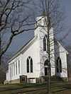
Mount Zion Presbyterian Church |
Upload image |
01978-12-19-0000December 19, 1978
(#78002152) |
Southeast of Chandlersville off State Route 146
39°51′45″N 81°44′59″W / 39.8625°N 81.749722°W / 39.8625; -81.749722 (Mount Zion Presbyterian Church) |
Rich Hill Township |
|
| 43 |
Muskingum College Campus Historic District |
|
01979-06-11-0000June 11, 1979
(#79001910) |
U.S. Route 22
39°59′47″N 81°44′09″W / 39.996389°N 81.735833°W / 39.996389; -81.735833 (Muskingum College Campus Historic District) |
New Concord |
|
| 44 |
Muskingum County Courthouse and Jail |
|
01973-07-16-0000July 16, 1973
(#73001515) |
4th and Main Sts.
39°56′26″N 82°00′26″W / 39.940556°N 82.007222°W / 39.940556; -82.007222 (Muskingum County Courthouse and Jail) |
Zanesville |
|
| 45 |
Muskingum River Lock No. 10 and Canal |
|
01978-12-19-0000December 19, 1978
(#78002165) |
Northern bank of the Muskingum River, north of the railroad bridge south to the lock terminals
39°56′02″N 82°00′11″W / 39.933889°N 82.003194°W / 39.933889; -82.003194 (Muskingum River Lock No. 10 and Canal) |
Zanesville |
|
| 46 |
Muskingum River Navigation Historic District |
|
02007-02-09-0000February 9, 2007
(#07000025) |
Coshocton, Muskingum, Morgan, Washington Counties
40°09′27″N 81°56′41″W / 40.157500°N 81.944722°W / 40.157500; -81.944722 (Muskingum River Navigation Historic District) |
Numerous jurisdictions |
|
| 47 |
Nashport Mound |
Upload image |
01973-05-24-0000May 24, 1973
(#73001512) |
Along the Licking River below Nashport[9]
40°03′37″N 82°09′57″W / 40.0603°N 82.1659°W / 40.0603; -82.1659 (Nashport Mound) |
Licking Township |
|
| 48 |
Ohio Power Company |
|
01980-11-25-0000November 25, 1980
(#80003198) |
604 Main St.
39°56′24″N 82°00′18″W / 39.94°N 82.005°W / 39.94; -82.005 (Ohio Power Company) |
Zanesville |
|
| 49 |
Paul Hall, Muskingum College |
|
01973-04-23-0000April 23, 1973
(#73001514) |
Layton Dr., Muskingum College campus
39°59′43″N 81°44′04″W / 39.995278°N 81.734444°W / 39.995278; -81.734444 (Paul Hall, Muskingum College) |
New Concord |
|
| 50 |
Peairs Homestead |
Upload image |
01979-02-27-0000February 27, 1979
(#79001919) |
East of Zanesville on State Route 146
39°54′44″N 81°53′53″W / 39.912222°N 81.898056°W / 39.912222; -81.898056 (Peairs Homestead) |
Salt Creek Township |
|
| 51 |
Philo II Archeological District |
Upload image |
01978-11-29-0000November 29, 1978
(#78002156) |
Western bank of the Muskingum River below Philo[10]
39°48′17″N 81°54′18″W / 39.8047°N 81.905°W / 39.8047; -81.905 (Philo II Archeological District) |
Harrison Township |
|
| 52 |
Pittsburg, Cincinnati, and St. Louis Depot |
|
01983-03-24-0000March 24, 1983
(#83002016) |
Market St.
39°56′34″N 82°00′36″W / 39.942778°N 82.01°W / 39.942778; -82.01 (Pittsburg, Cincinnati, and St. Louis Depot) |
Zanesville |
|
| 53 |
Prospect Place |
|
01979-05-10-0000May 10, 1979
(#79001913) |
South of Trinway on State Route 60
40°08′05″N 82°00′42″W / 40.134722°N 82.011667°W / 40.134722; -82.011667 (Prospect Place) |
Cass Township |
|
| 54 |
Putnam Historic District |
|
01975-06-30-0000June 30, 1975
(#75001511) |
Bounded by the former Penn Central Railroad tracks, Van Buren St., and the Muskingum River
39°55′55″N 82°00′26″W / 39.931944°N 82.007222°W / 39.931944; -82.007222 (Putnam Historic District) |
Zanesville |
|
| 55 |
C.W. Ransbottom House |
|
01980-03-11-0000March 11, 1980
(#80003185) |
291 Washington St.
39°48′35″N 82°04′16″W / 39.809861°N 82.071111°W / 39.809861; -82.071111 (C.W. Ransbottom House) |
Roseville |
|
| 56 |
Edward Ransbottom House |
|
01980-03-11-0000March 11, 1980
(#80003186) |
99 Main St.
39°48′22″N 82°04′22″W / 39.806000°N 82.072778°W / 39.806000; -82.072778 (Edward Ransbottom House) |
Roseville |
|
| 57 |
Frank M. Ransbottom House |
|
01980-03-11-0000March 11, 1980
(#80003187) |
289 Washington St.
39°48′35″N 82°04′16″W / 39.809722°N 82.071111°W / 39.809722; -82.071111 (Frank M. Ransbottom House) |
Roseville |
|
| 58 |
Mort Ransbottom House |
|
01980-03-11-0000March 11, 1980
(#80003188) |
152 N. Main St.
39°48′25″N 82°04′20″W / 39.807083°N 82.072222°W / 39.807083; -82.072222 (Mort Ransbottom House) |
Roseville |
|
| 59 |
Adam Rider House |
Upload image |
01979-11-29-0000November 29, 1979
(#79001911) |
9350 Athens Rd., south of Roseville
39°47′43″N 82°03′46″W / 39.795278°N 82.062778°W / 39.795278; -82.062778 (Adam Rider House) |
Clay Township |
|
| 60 |
Roseville High School |
|
01978-03-30-0000March 30, 1978
(#78002157) |
Stokeley and Perry Sts.
39°48′36″N 82°04′24″W / 39.810000°N 82.073333°W / 39.810000; -82.073333 (Roseville High School) |
Roseville |
|
| 61 |
"S" Bridge II |
|
01973-04-23-0000April 23, 1973
(#73001513) |
U.S. Route 40 west of New Concord
39°59′35″N 81°44′48″W / 39.993056°N 81.746667°W / 39.993056; -81.746667 ("S" Bridge II) |
Union Township |
|
| 62 |
St. James Episcopal Church |
|
01978-10-02-0000October 2, 1978
(#78002167) |
155 N. 6th St.
39°56′35″N 82°00′20″W / 39.943056°N 82.005556°W / 39.943056; -82.005556 (St. James Episcopal Church) |
Zanesville |
|
| 63 |
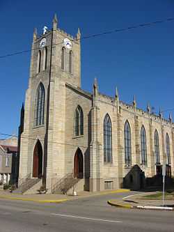
St. John's Evangelical Lutheran Church |
|
01980-01-03-0000January 3, 1980
(#80003189) |
South of Stovertown on State Route 555
39°49′59″N 81°59′17″W / 39.833056°N 81.988056°W / 39.833056; -81.988056 (St. John's Evangelical Lutheran Church) |
Brush Creek Township |
|
| 64 |
St. John's Lutheran Church |
|
01982-12-02-0000December 2, 1982
(#82001484) |
Market and N. 7th Sts.
39°56′31″N 82°00′15″W / 39.941944°N 82.004167°W / 39.941944; -82.004167 (St. John's Lutheran Church) |
Zanesville |
|
| 65 |
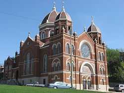
St. Nicholas's Catholic Church |
|
01975-09-25-0000September 25, 1975
(#75001512) |
925 Main St.
39°56′24″N 82°00′04″W / 39.94°N 82.001111°W / 39.94; -82.001111 (St. Nicholas's Catholic Church) |
Zanesville |
|
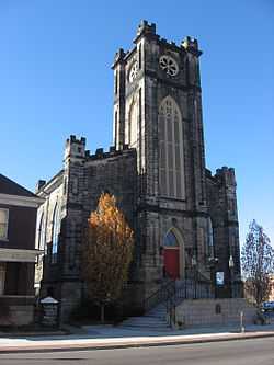
| 66 |
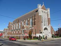
St. Thomas Aquinas Church |
|
01980-03-11-0000March 11, 1980
(#80003199) |
130 N. 5th St.
39°56′35″N 82°00′24″W / 39.943056°N 82.006667°W / 39.943056; -82.006667 (St. Thomas Aquinas Church) |
Zanesville |
|
| 67 |
Salt Creek Covered Bridge |
|
01974-09-10-0000September 10, 1974
(#74001587) |
3 mi (4.8 km) northwest of Norwich
39°59′55″N 81°50′24″W / 39.998611°N 81.84°W / 39.998611; -81.84 (Salt Creek Covered Bridge) |
Perry Township |
|
| 68 |
Frederick Augustus Seborn House |
|
01978-04-04-0000April 4, 1978
(#78002166) |
1115-1119 Maysville Pike
39°55′15″N 82°00′36″W / 39.920833°N 82.01°W / 39.920833; -82.01 (Frederick Augustus Seborn House) |
Zanesville |
|
| 69 |
William R. Smith House |
|
01982-06-01-0000June 1, 1982
(#82003627) |
920 Marietta St.
39°56′10″N 82°00′09″W / 39.936111°N 82.0025°W / 39.936111; -82.0025 (William R. Smith House) |
Zanesville |
|
| 70 |
David Stormont House |
|
01983-04-21-0000April 21, 1983
(#83002017) |
103 W. Main St.
39°59′37″N 81°44′18″W / 39.993611°N 81.738333°W / 39.993611; -81.738333 (David Stormont House) |
New Concord |
|
| 71 |
Capt. James Boggs Tannehill House |
|
01979-08-27-0000August 27, 1979
(#79001921) |
367 Taylor St.
39°58′03″N 82°00′15″W / 39.9675°N 82.004167°W / 39.9675; -82.004167 (Capt. James Boggs Tannehill House) |
Zanesville |
|
| 72 |
William C. Tanner House |
Upload image |
01979-09-17-0000September 17, 1979
(#79001922) |
Northwest of Zanesville
39°59′49″N 82°05′53″W / 39.996944°N 82.098056°W / 39.996944; -82.098056 (William C. Tanner House) |
Falls Township |
|
| 73 |
Tavener-Sears Tavern |
Upload image |
01982-04-29-0000April 29, 1982
(#82003621) |
Main St. in Mount Sterling
39°57′24″N 82°09′02″W / 39.956667°N 82.150556°W / 39.956667; -82.150556 (Tavener-Sears Tavern) |
Hopewell Township |
|
| 74 |
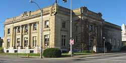
US Post Office and Federal Building-Zanesville |
|
01988-02-11-0000February 11, 1988
(#88000071) |
65 S. 5th St.
39°56′21″N 82°00′25″W / 39.939167°N 82.006944°W / 39.939167; -82.006944 (US Post Office and Federal Building-Zanesville) |
Zanesville |
Designed by architect George F. Hammond
|
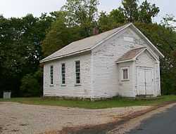
| 75 |
West Union School |
|
01978-03-30-0000March 30, 1978
(#78002155) |
South of Norwich on County Road 200
39°56′56″N 81°47′59″W / 39.948889°N 81.799722°W / 39.948889; -81.799722 (West Union School) |
Union Township |
|
| 76 |
West View |
|
01982-03-05-0000March 5, 1982
(#82003628) |
444 Sunkel Boulevard
39°57′50″N 82°00′25″W / 39.963889°N 82.006944°W / 39.963889; -82.006944 (West View) |
Zanesville |
|
| 77 |
Perry Wiles Grocery Company |
|
01980-11-25-0000November 25, 1980
(#80003200) |
32-36 N. 3rd St.
39°56′27″N 82°00′32″W / 39.940833°N 82.008889°W / 39.940833; -82.008889 (Perry Wiles Grocery Company) |
Zanesville |
|
| 78 |
Y Bridge |
|
01973-11-02-0000November 2, 1973
(#73001516) |
At the foot of Main St., over the Licking and Muskingum rivers
39°56′25″N 82°00′48″W / 39.940278°N 82.013333°W / 39.940278; -82.013333 (Y Bridge) |
Zanesville |
|
| 79 |
Zanesville YMCA |
|
01985-10-29-0000October 29, 1985
(#83002018) |
34 S. 5th St.
39°56′20″N 82°00′24″W / 39.938889°N 82.006667°W / 39.938889; -82.006667 (Zanesville YMCA) |
Zanesville |
Destroyed
|
| 80 |
Zanesville YWCA |
|
01978-07-17-0000July 17, 1978
(#78002168) |
49 N. 6th St.
39°56′28″N 82°00′20″W / 39.941111°N 82.005556°W / 39.941111; -82.005556 (Zanesville YWCA) |
Zanesville |
|