National Register of Historic Places listings in Morton County, Kansas
Location of Morton County in Kansas
This is a list of the National Register of Historic Places listings in Morton County, Kansas. It is intended to be a complete list of the properties and districts on the National Register of Historic Places in Morton County, Kansas, United States. The locations of National Register properties and districts for which the latitude and longitude coordinates are included below, may be seen in an online map.
There are 7 properties and districts listed on the National Register in the county.
- This National Park Service list is complete through NPS recent listings posted April 24, 2015.[1]
Current listings
| [2] | Name on the Register[3] | Image | Date listed[4] | Location | City or town | Description |
|---|---|---|---|---|---|---|
| 1 | Morton County WPA Bridge | 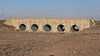 |
(#86003356) |
6 miles west and 4 miles north of Richfield 37°19′06″N 101°54′02″W / 37.318208°N 101.900616°W |
Richfield | |
| 2 | Point of Rocks — Middle Spring Santa Fe Trail Historic District | _at_sundown_2.JPG) |
(#13000151) |
2.5 miles (4.0 km) south of K-51 and 2 miles (3.2 km) west of K-27 37°06′14″N 101°56′19″W / 37.103846°N 101.938631°W |
Elkhart vicinity | |
| 3 | Santa Fe Trail — Cimarron National Grassland Segment 1 | 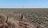 |
(#13000132) |
2.0 miles (3.2 km) south of K-51 at Colorado–Kansas state line Coordinates missing |
Elkhart vicinity | |
| 4 | Santa Fe Trail — Cimarron National Grassland Segment 2 | Upload image | (#13000133) |
1.66 miles (2.67 km) south of K-51 and 1 mile (1.6 km) east of County Road 2 Coordinates missing |
Elkhart vicinity | |
| 5 | Santa Fe Trail — Cimarron National Grassland Segment 3 | 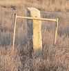 |
(#13000134) |
FSR-600, east and west sides of K-27 37°07′34″N 101°53′58″W / 37.126022°N 101.899463°W |
Elkhart vicinity | |
| 6 | Santa Fe Trail — Cimarron National Grassland Segment 4 | Upload image | (#13000135) |
2.5 miles (4.0 km) east of K-27, north of FSR-600 Coordinates missing |
Elkhart vicinity | |
| 7 | Santa Fe Trail — Cimarron National Grassland Segment 5 | 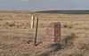 |
(#13000136) |
7 miles (11 km) north of US-56 along County Road 16 37°10′09″N 101°46′23″W / 37.169268°N 101.773141°W |
Wilburton vicinity |
See also
- List of National Historic Landmarks in Kansas
- National Register of Historic Places listings in Kansas
References
- ↑ "National Register of Historic Places: Weekly List Actions". National Park Service, United States Department of the Interior. Retrieved on April 24, 2015.
- ↑ Numbers represent an ordering by significant words. Various colorings, defined here, differentiate National Historic Landmarks and historic districts from other NRHP buildings, structures, sites or objects.
- ↑ "National Register Information System". National Register of Historic Places. National Park Service. 2010-07-09.
- ↑ The eight-digit number below each date is the number assigned to each location in the National Register Information System database, which can be viewed by clicking the number.


| ||||||||||||||||||||||||||
| |||||||||||||||||