National Register of Historic Places listings in Morrow County, Ohio
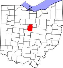
Location of Morrow County in Ohio
This is a list of the National Register of Historic Places listings in Morrow County, Ohio.
This is intended to be a complete list of the properties and districts on the National Register of Historic Places in Morrow County, Ohio, United States. The locations of National Register properties and districts for which the latitude and longitude coordinates are included below, may be seen in a Google map.[1]
There are 15 properties and districts listed on the National Register in the county. Another property was once listed but has been removed.
- This National Park Service list is complete through NPS recent listings posted May 1, 2015.[2]
Current listings
| [3] |
Name on the Register[4] |
Image |
Date listed[5] |
Location |
City or town |
Description |
|---|
| 1 |
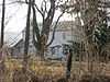
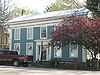
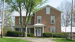
Reuben Benedict House |
|
02000-05-08-0000May 8, 2000
(#00000419) |
1463 County Road 24, west of Marengo
40°24′29″N 82°51′48″W / 40.408056°N 82.863333°W / 40.408056; -82.863333 (Reuben Benedict House) |
Peru Township |
|
| 2 |
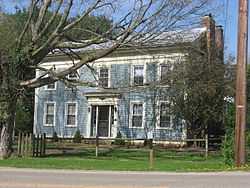
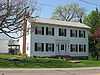
Samuel P. Brown House |
|
01982-03-15-0000March 15, 1982
(#82003619) |
South of Fulton on Worthington-New Haven Rd.
40°26′31″N 82°50′48″W / 40.441944°N 82.846667°W / 40.441944; -82.846667 (Samuel P. Brown House) |
Lincoln Township |
|
| 3 |
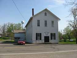
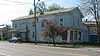
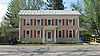
Chester Town Hall |
|
01979-08-21-0000August 21, 1979
(#79002752) |
Sandusky and Short Sts.
40°28′48″N 82°40′57″W / 40.48°N 82.6825°W / 40.48; -82.6825 (Chester Town Hall) |
Chesterville |
|
| 4 |
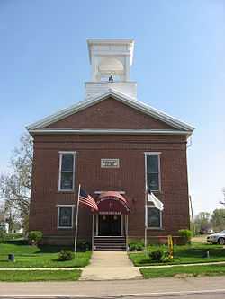
Chesterville Methodist Church |
|
01979-08-21-0000August 21, 1979
(#79002754) |
Sandusky and East Sts.
40°28′46″N 82°40′54″W / 40.479444°N 82.681667°W / 40.479444; -82.681667 (Chesterville Methodist Church) |
Chesterville |
|
| 5 |
Floral Hall |
|
01976-12-12-0000December 12, 1976
(#76001503) |
Morrow County Fairgrounds
40°32′39″N 82°49′52″W / 40.544167°N 82.831111°W / 40.544167; -82.831111 (Floral Hall) |
Mount Gilead |
|
| 6 |
Jarvis House |
|
01979-08-21-0000August 21, 1979
(#79002756) |
77 S. Portland St.
40°28′44″N 82°41′00″W / 40.478889°N 82.683333°W / 40.478889; -82.683333 (Jarvis House) |
Chesterville |
|
| 7 |
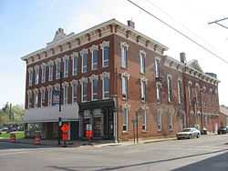
Levering Hall |
|
01980-05-29-0000May 29, 1980
(#80003180) |
12 S. Main St.
40°32′55″N 82°49′41″W / 40.548611°N 82.828056°W / 40.548611; -82.828056 (Levering Hall) |
Mount Gilead |
|
| 8 |
Enos Miles House |
|
01979-08-21-0000August 21, 1979
(#79002758) |
154 S. Portland St.
40°28′41″N 82°41′02″W / 40.478056°N 82.683889°W / 40.478056; -82.683889 (Enos Miles House) |
Chesterville |
|
| 9 |
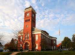
Morrow County Courthouse and Jail |
|
01974-07-25-0000July 25, 1974
(#74001586) |
Courthouse Sq.
40°32′57″N 82°49′35″W / 40.549167°N 82.826389°W / 40.549167; -82.826389 (Morrow County Courthouse and Jail) |
Mount Gilead |
|
| 10 |
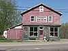
Old Bartlett and Goble Store |
|
01979-08-21-0000August 21, 1979
(#79002748) |
Sandusky and Portland Sts.
40°28′47″N 82°41′00″W / 40.479722°N 82.683333°W / 40.479722; -82.683333 (Old Bartlett and Goble Store) |
Chesterville |
|
| 11 |
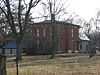
Old Union School |
|
01979-08-21-0000August 21, 1979
(#79002743) |
63 E. Denmon Ave.
40°28′51″N 82°40′56″W / 40.480833°N 82.682222°W / 40.480833; -82.682222 (Old Union School) |
Chesterville |
|
| 12 |
A.B. Sears House |
|
01979-08-21-0000August 21, 1979
(#79002745) |
52 W. Sandusky St.
40°28′49″N 82°41′07″W / 40.480278°N 82.685278°W / 40.480278; -82.685278 (A.B. Sears House) |
Chesterville |
|
| 13 |
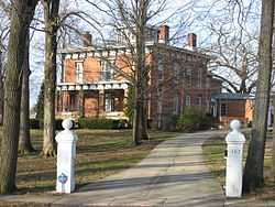
James S. Trimble House |
|
01982-11-30-0000November 30, 1982
(#82001481) |
187 Iberia St.
40°33′07″N 82°50′02″W / 40.551944°N 82.833889°W / 40.551944; -82.833889 (James S. Trimble House) |
Mount Gilead |
|
| 14 |
U.S. Post Office |
|
01979-08-21-0000August 21, 1979
(#79002750) |
44 E. Sandusky St.
40°28′46″N 82°40′58″W / 40.479444°N 82.682778°W / 40.479444; -82.682778 (U.S. Post Office) |
Chesterville |
|
| 15 |
Wood Commercial Building |
|
01979-08-21-0000August 21, 1979
(#79002747) |
Sandusky and Portland Sts.
40°28′47″N 82°41′01″W / 40.479722°N 82.683611°W / 40.479722; -82.683611 (Wood Commercial Building) |
Chesterville |
|
Former listing
See also
References
- ↑ The latitude and longitude information provided in this table was derived originally from the National Register Information System, which has been found to be fairly accurate for about 99% of listings. For about 1% of NRIS original coordinates, experience has shown that one or both coordinates are typos or otherwise extremely far off; some corrections may have been made. A more subtle problem causes many locations to be off by up to 150 yards, depending on location in the country: most NRIS coordinates were derived from tracing out latitude and longitudes off of USGS topographical quadrant maps created under the North American Datum of 1927, which differs from the current, highly accurate WGS84 GPS system used by most on-line maps. Chicago is about right, but NRIS longitudes in Washington are higher by about 4.5 seconds, and are lower by about 2.0 seconds in Maine. Latitudes differ by about 1.0 second in Florida. Some locations in this table may have been corrected to current GPS standards.
- ↑ "National Register of Historic Places: Weekly List Actions". National Park Service, United States Department of the Interior. Retrieved on May 1, 2015.
- ↑ 3.0 3.1 Numbers represent an ordering by significant words. Various colorings, defined here, differentiate National Historic Landmarks and historic districts from other NRHP buildings, structures, sites or objects.
- ↑ "National Register Information System". National Register of Historic Places. National Park Service. 2008-04-24.
- ↑ The eight-digit number below each date is the number assigned to each location in the National Register Information System database, which can be viewed by clicking the number.
|
|---|
| | Lists by county | | |
|---|
| | Lists by city | |
|---|
| | Other lists | |
|---|
| |
|