National Register of Historic Places listings in Montezuma County, Colorado

Location of Montezuma County in Colorado
This is a list of the National Register of Historic Places listings in Montezuma County, Colorado. It is intended to be a complete list of the properties and districts on the National Register of Historic Places in Montezuma County, Colorado, United States. The locations of National Register properties and districts for which the latitude and longitude coordinates are included below, may be seen in a Google map.[1]
There are 34 properties and districts listed on the National Register in the county, including 2 National Historic Landmarks.
- This National Park Service list is complete through NPS recent listings posted May 1, 2015.[2]
Listings county-wide
| [3] | Name on the Register | Image | Date listed[4] | Location | City or town | Description |
|---|---|---|---|---|---|---|
| 1 | Albert Porter Pueblo | Upload image | (#99000266) |
Address Restricted |
Yellow Jacket | |
| 2 | Anasazi Archeological District | Upload image | (#84001273) |
Address Restricted |
Dolores | |
| 3 | Archeological Site no. 5MT4700 | Upload image | (#99000685) |
Address Restricted |
Yellow Jacket | |
| 4 | Bass Site | Upload image | (#99000654) |
Address Restricted |
Yellow Jacket | |
| 5 | Bauer Bank Block | 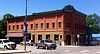 |
(#03001009) |
107 W. Grand Ave. 37°20′42″N 108°17′20″W / 37.345°N 108.288889°W |
Mancos | |
| 6 | Cannonball Ruins | 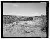 |
(#97000378) |
Address Restricted |
Cortez | |
| 7 | Ertel Funeral Home | Upload image | (#95001248) |
42 N. Market St. 37°20′58″N 108°35′03″W / 37.349444°N 108.584167°W |
Cortez | |
| 8 | Escalante Ruin | |
(#75000527) |
Address Restricted 37°28′40″N 108°32′44″W / 37.477766°N 108.545668°W |
Dolores | |
| 9 | Hovenweep National Monument | 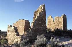 |
(#66000250) |
Northwest of Cortez 37°26′35″N 108°58′56″W / 37.443056°N 108.982222°W |
Cortez | |
| 10 | Indian Camp Ranch Archeological District | Upload image | (#12000145) |
Address Restricted |
Cortez vicinity | |
| 11 | Joe Ben Wheat Site Complex | Upload image | (#03001383) |
Address Restricted |
Yellow Jacket | |
| 12 | James A. Lancaster Site | Upload image | (#80000914) |
Address Restricted |
Pleasant View | |
| 13 | Lebanon School | Upload image | (#96000543) |
24925 County Road T 37°27′28″N 108°35′29″W / 37.457778°N 108.591389°W |
Dolores | |
| 14 | Lost Canyon Archeological District | Upload image | (#88001909) |
Address Restricted |
Mancos | |
| 15 | Lowry Ruin |  |
(#66000253) |
30 miles (48 km) northwest of Cortez via U.S. Route 160 Coordinates missing |
Pleasant View | |
| 16 | Mancos High School | Upload image | (#91001740) |
350 Grand Ave. 37°20′44″N 108°17′32″W / 37.345556°N 108.292222°W |
Mancos | |
| 17 | Mancos Opera House | 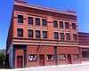 |
(#87002183) |
136 W. Grand Ave. 37°20′11″N 108°17′23″W / 37.336389°N 108.289722°W |
Mancos | |
| 18 | Mesa Verde Administrative District |  |
(#87001410) |
Area at head of Spruce Canyon off park service road 37°10′59″N 108°29′26″W / 37.183056°N 108.490556°W |
Mesa Verde National Park | |
| 19 | Mesa Verde National Park |  |
(#66000251) |
10 miles (16 km) east of Cortez on U.S. Route 160 37°14′52″N 108°27′06″W / 37.247821°N 108.451595°W |
Cortez | |
| 20 | Mitchell Springs Archeological Site | Upload image | (#01001207) |
7755 Road 25 37°19′30″N 108°35′44″W / 37.324893°N 108.595553°W |
Cortez | |
| 21 | Montezuma Valley Irrigation Company Flume No. 6 | 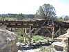 |
(#12000146) |
Approximately 4 miles (6.4 km) east of Cortez on US 160 Coordinates missing |
Cortez vicinity | |
| 22 | Montezuma Valley National Bank and Store Building | 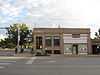 |
(#08001317) |
2-8 Main St. 37°20′55″N 108°35′06″W / 37.34864°N 108.58502°W |
Cortez | |
| 23 | Mud Springs Pueblo | Upload image | (#82001020) |
Address Restricted |
Cortez | |
| 24 | Painted Hand Pueblo | Upload image | (#13000576) |
Address Restricted |
Pleasant View | |
| 25 | Pigge Site | Upload image | (#80000915) |
Address Restricted |
Pleasant View | |
| 26 | Roy's Ruin | Upload image | (#91002027) |
Address Restricted |
Cortez | |
| 27 | Sand Canyon Archaeological District | |
(#05000138) |
Address Restricted |
Cortez | |
| 28 | Seven Towers Pueblo | Upload image | (#99000653) |
Address Restricted |
Yellow Jacket | |
| 29 | Southern Hotel | Upload image | (#89000018) |
101 S. 5th St. 37°28′35″N 108°30′09″W / 37.476389°N 108.5025°W |
Dolores | |
| 30 | Ute Mountain Ute Mancos Canyon Historic District |  |
(#72000273) |
Address Restricted |
Durango | |
| 31 | Woods Canyon Pueblo | Upload image | (#99000652) |
Address Restricted |
Yellow Jacket | |
| 32 | Wrightsman House | Upload image | (#97000045) |
209 Bauer Ave. 37°20′45″N 108°17′25″W / 37.345833°N 108.290278°W |
Mancos | |
| 33 | Yellowjacket Pueblo (5-MT-5) | Upload image | (#85002701) |
Address Restricted |
Yellow Jacket | |
| 34 | Yucca House National Monument | 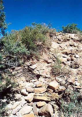 |
(#66000252) |
12 miles (19 km) south of Cortez via U.S. Route 666 37°15′00″N 108°41′07″W / 37.25°N 108.685278°W |
Cortez |
See also
| Wikimedia Commons has media related to National Register of Historic Places in Montezuma County, Colorado. |
- List of National Historic Landmarks in Colorado
- National Register of Historic Places listings in Colorado
References
- ↑ The latitude and longitude information provided in this table was derived originally from the National Register Information System, which has been found to be fairly accurate for about 99% of listings. For about 1% of NRIS original coordinates, experience has shown that one or both coordinates are typos or otherwise extremely far off; some corrections may have been made. A more subtle problem causes many locations to be off by up to 150 yards, depending on location in the country: most NRIS coordinates were derived from tracing out latitude and longitudes off of USGS topographical quadrant maps created under the North American Datum of 1927, which differs from the current, highly accurate WGS84 GPS system used by most on-line maps. Chicago is about right, but NRIS longitudes in Washington are higher by about 4.5 seconds, and are lower by about 2.0 seconds in Maine. Latitudes differ by about 1.0 second in Florida. Some locations in this table may have been corrected to current GPS standards.
- ↑ "National Register of Historic Places: Weekly List Actions". National Park Service, United States Department of the Interior. Retrieved on May 1, 2015.
- ↑ Numbers represent an ordering by significant words. Various colorings, defined here, differentiate National Historic Landmarks and historic districts from other NRHP buildings, structures, sites or objects.
- ↑ The eight-digit number below each date is the number assigned to each location in the National Register Information System database, which can be viewed by clicking the number.
| ||||||||||||||||||||||||||
| |||||||||||||||||||||||||||||