| [3] |
Name on the Register[4] |
Image |
Date listed[5] |
Location |
City or town |
Description |
|---|
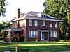
| 1 |
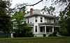
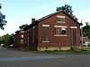
Abramson House |
Upload image |
01995-09-07-0000September 7, 1995
(#95001092) |
127 Crescent Heights
34°35′29″N 91°11′52″W / 34.591389°N 91.197778°W / 34.591389; -91.197778 (Abramson House) |
Holly Grove |
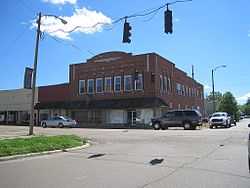
|
| 2 |
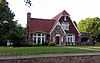
Anderson Boarding House |
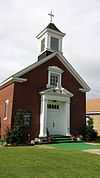
Upload image |
01984-11-01-0000November 1, 1984
(#84000180) |
201 Main St.
34°41′44″N 91°19′00″W / 34.695556°N 91.316667°W / 34.695556; -91.316667 (Anderson Boarding House) |
Clarendon |
|
| 3 |
Bank of Clarendon |
|
01984-11-01-0000November 1, 1984
(#84000183) |
125 Court St.
34°41′47″N 91°19′07″W / 34.696389°N 91.318611°W / 34.696389; -91.318611 (Bank of Clarendon) |
Clarendon |
|
| 4 |
Bateman-Griffith House |
|
01984-11-01-0000November 1, 1984
(#84000184) |
316 Jefferson St.
34°41′56″N 91°18′59″W / 34.698889°N 91.316389°W / 34.698889; -91.316389 (Bateman-Griffith House) |
Clarendon |
|
| 5 |
Baytown Site |
Upload image |
01976-05-13-0000May 13, 1976
(#76000440) |
Southeastern quarter of the southwestern quarter of Section 2345, Section 2 South, Range 1 West[6]
34°22′57″N 91°03′54″W / 34.382500°N 91.065000°W / 34.382500; -91.065000 (Baytown Site) |
Indian Bay |
|
| 6 |
William Black Family House |
|
01976-12-12-0000December 12, 1976
(#76000437) |
311 W. Ash St.
34°53′07″N 91°11′44″W / 34.885278°N 91.195556°W / 34.885278; -91.195556 (William Black Family House) |
Brinkley |
|
| 7 |
Bondi Brothers Store |
|
01984-11-01-0000November 1, 1984
(#84000185) |
104 Madison St.
34°41′45″N 91°19′03″W / 34.695833°N 91.3175°W / 34.695833; -91.3175 (Bondi Brothers Store) |
Clarendon |
|
| 8 |
Bounds Building |
Upload image |
01984-11-01-0000November 1, 1984
(#84000186) |
105 2nd St.
34°41′47″N 91°19′02″W / 34.696389°N 91.317222°W / 34.696389; -91.317222 (Bounds Building) |
Clarendon |
|
| 9 |
Capps House |
Upload image |
01990-06-21-0000June 21, 1990
(#90000877) |
County Road 48 east of its junction with Highway 17
34°30′04″N 91°07′59″W / 34.501111°N 91.133056°W / 34.501111; -91.133056 (Capps House) |
Lawrenceville |
|
| 10 |
Clarendon Methodist-Episcopal Church South |
|
01984-11-01-0000November 1, 1984
(#84000187) |
121 3rd St.
34°41′53″N 91°19′01″W / 34.698056°N 91.316944°W / 34.698056; -91.316944 (Clarendon Methodist-Episcopal Church South) |
Clarendon |
|
| 11 |
Cumberland Presbyterian Church |
|
01976-07-30-0000July 30, 1976
(#76000438) |
120 Washington St.
34°41′42″N 91°18′44″W / 34.695°N 91.312222°W / 34.695; -91.312222 (Cumberland Presbyterian Church) |
Clarendon |
|
| 12 |
Ellas-McKay House |
Upload image |
01978-12-08-0000December 8, 1978
(#78000613) |
404 N. Wells St.
34°41′45″N 91°18′48″W / 34.695833°N 91.313333°W / 34.695833; -91.313333 (Ellas-McKay House) |
Clarendon |
|
| 13 |
Ewan Building |
Upload image |
01984-11-01-0000November 1, 1984
(#84000188) |
124-128 2nd St.
34°41′48″N 91°19′06″W / 34.696667°N 91.318333°W / 34.696667; -91.318333 (Ewan Building) |
Clarendon |
|
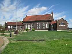
| 14 |
Fargo Training School Historic District |
Upload image |
02010-05-27-0000May 27, 2010
(#10000287) |
Floyd Brown Dr., east of M and A Rd.
34°57′04″N 91°10′28″W / 34.951067°N 91.174442°W / 34.951067; -91.174442 (Fargo Training School Historic District) |
Fargo |
|
| 15 |
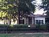
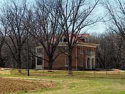
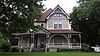
Orth C. Galloway House |
Upload image |
01980-05-23-0000May 23, 1980
(#80000779) |
504 Park St.
34°42′02″N 91°18′46″W / 34.700556°N 91.312778°W / 34.700556; -91.312778 (Orth C. Galloway House) |
Clarendon |
|
| 16 |
Gazzola and Vaccaro Building |
|
01982-12-22-0000December 22, 1982
(#82000865) |
131-133 W. Cypress
34°53′14″N 91°11′34″W / 34.887222°N 91.192778°W / 34.887222; -91.192778 (Gazzola and Vaccaro Building) |
Brinkley |
|
| 17 |
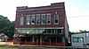
Goldman and Son Store |
Upload image |
01984-11-01-0000November 1, 1984
(#84000189) |
101 Main St.
34°41′44″N 91°19′05″W / 34.695556°N 91.318056°W / 34.695556; -91.318056 (Goldman and Son Store) |
Clarendon |
|
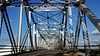
| 18 |
Highway 79 Bridge |
|
01984-11-01-0000November 1, 1984
(#84000190) |
U.S. Route 79 over the White River
34°41′22″N 91°19′01″W / 34.689444°N 91.316944°W / 34.689444; -91.316944 (Highway 79 Bridge) |
Clarendon |
|
| 19 |
Holly Grove Historic District |
Upload image |
01979-02-02-0000February 2, 1979
(#79000446) |
Main and Pine Sts.
34°35′44″N 91°12′03″W / 34.595556°N 91.200833°W / 34.595556; -91.200833 (Holly Grove Historic District) |
Holly Grove |
|
| 20 |
Holly Grove Presbyterian Church |
Upload image |
01991-05-13-0000May 13, 1991
(#91000581) |
310 2nd St.
34°35′46″N 91°11′53″W / 34.596156°N 91.197992°W / 34.596156; -91.197992 (Holly Grove Presbyterian Church) |
Holly Grove |
|
| 21 |
Jefferies Building |
Upload image |
01984-11-01-0000November 1, 1984
(#84000191) |
122 Madison St.
34°41′43″N 91°19′03″W / 34.695278°N 91.3175°W / 34.695278; -91.3175 (Jefferies Building) |
Clarendon |
|
| 22 |
Jefferies-Crabtree House |
|
01984-11-01-0000November 1, 1984
(#84000192) |
300 Jefferson St.
34°41′55″N 91°18′59″W / 34.698611°N 91.316389°W / 34.698611; -91.316389 (Jefferies-Crabtree House) |
Clarendon |
Mistakenly listed as "Jefferies-Craptree House" in the NRIS[7]
|
| 23 |
Lair House |
Upload image |
01998-04-23-0000April 23, 1998
(#98000371) |
Junction of Stone and Elm Sts.
34°35′43″N 91°11′46″W / 34.595278°N 91.196111°W / 34.595278; -91.196111 (Lair House) |
Holly Grove |
|
| 24 |
Lick Skillet Railroad Work Station Historic District |
|
01992-06-01-0000June 1, 1992
(#92000558) |
Junction of E. Cypress St. and New Orleans Ave.
34°53′16″N 91°11′30″W / 34.887778°N 91.191667°W / 34.887778; -91.191667 (Lick Skillet Railroad Work Station Historic District) |
Brinkley |
|
| 25 |
Lo Beele House |
|
01982-12-22-0000December 22, 1982
(#82000866) |
312 New York Ave.
34°53′23″N 91°11′47″W / 34.889722°N 91.196389°W / 34.889722; -91.196389 (Lo Beele House) |
Brinkley |
|
| 26 |
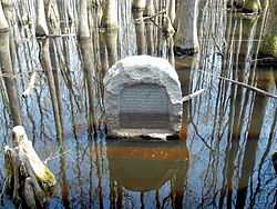
Louisiana Purchase Survey Marker |
|
01972-02-23-0000February 23, 1972
(#72000206) |
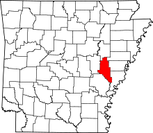
Southeast of Blackton at the corner of Monroe and Phillips counties
34°38′48″N 91°03′05″W / 34.646667°N 91.051389°W / 34.646667; -91.051389 (Louisiana Purchase Survey Marker) |
Blackton |
Extends into Lee and Phillips counties
|
| 27 |
Manning, Lee and Moore Law Office |
|
01984-11-01-0000November 1, 1984
(#84000193) |
109 Court St.
34°41′46″N 91°19′07″W / 34.696111°N 91.318611°W / 34.696111; -91.318611 (Manning, Lee and Moore Law Office) |
Clarendon |
|
| 28 |
Marston House |
Upload image |
01984-11-01-0000November 1, 1984
(#84000194) |
429 Main St.
34°41′44″N 91°18′44″W / 34.695556°N 91.312222°W / 34.695556; -91.312222 (Marston House) |
Clarendon |
|
| 29 |
Memphis to Little Rock Road-Henard Cemetery Road Segment |
Upload image |
02003-05-30-0000May 30, 2003
(#03000470) |
Henard Cemetery Rd.
34°59′22″N 91°09′13″W / 34.989444°N 91.153611°W / 34.989444; -91.153611 (Memphis to Little Rock Road-Henard Cemetery Road Segment) |
Zent |
Segment of the Trail of Tears
|
| 30 |
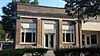
Merchants and Planters Bank |
|
01982-12-22-0000December 22, 1982
(#82000867) |
214 Madison
34°41′35″N 91°18′49″W / 34.693056°N 91.313611°W / 34.693056; -91.313611 (Merchants and Planters Bank) |
Clarendon |
|
| 31 |
Midland Depot |
|
01984-11-01-0000November 1, 1984
(#84000195) |
205 Midland St.
34°41′16″N 91°18′36″W / 34.687778°N 91.31°W / 34.687778; -91.31 (Midland Depot) |
Clarendon |
|
| 32 |
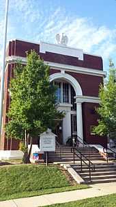
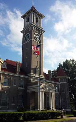
Monroe County Courthouse |
|
01976-10-14-0000October 14, 1976
(#76000439) |
Courthouse Sq.
34°41′33″N 91°18′51″W / 34.6925°N 91.314167°W / 34.6925; -91.314167 (Monroe County Courthouse) |
Clarendon |
|
| 33 |
Moore-Jacobs House |
|
01983-09-29-0000September 29, 1983
(#83001160) |
500 N. Main St.
34°41′52″N 91°18′49″W / 34.697778°N 91.313611°W / 34.697778; -91.313611 (Moore-Jacobs House) |
Clarendon |
|
| 34 |
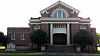
Mount Zion Missionary Baptist Church |
Upload image |
01986-11-04-0000November 4, 1986
(#86002951) |
409 S. Main St.
34°52′56″N 91°11′39″W / 34.882222°N 91.194167°W / 34.882222; -91.194167 (Mount Zion Missionary Baptist Church) |
Brinkley |
|
| 35 |
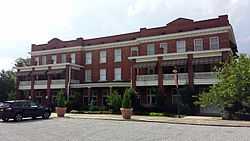
New South Inn |
Upload image |
01984-11-01-0000November 1, 1984
(#84000196) |
132-164 2nd St.
34°41′15″N 91°18′29″W / 34.6875°N 91.308056°W / 34.6875; -91.308056 (New South Inn) |
Clarendon |
|
| 36 |
Rusher Hotel |
|
01986-07-18-0000July 18, 1986
(#86001664) |
127 W. Cedar
34°53′15″N 91°11′32″W / 34.8875°N 91.192222°W / 34.8875; -91.192222 (Rusher Hotel) |
Brinkley |
|
| 37 |
St. John the Baptist Catholic Church |
|
01992-10-02-0000October 2, 1992
(#92001283) |
Southwestern corner of the junction of New Orleans and W. Ash St.
34°53′07″N 91°11′35″W / 34.885278°N 91.193056°W / 34.885278; -91.193056 (St. John the Baptist Catholic Church) |
Brinkley |
|
| 38 |
James A. Walls House |
Upload image |
01980-06-09-0000June 9, 1980
(#80000780) |
Off Highway 17
34°35′45″N 91°11′38″W / 34.595833°N 91.193889°W / 34.595833; -91.193889 (James A. Walls House) |
Holly Grove |
|
_001.jpg)