National Register of Historic Places listings in Moffat County, Colorado

Location of Moffat County in Colorado
This is a list of the National Register of Historic Places listings in Moffat County, Colorado. It is intended to be a complete list of the properties and districts on the National Register of Historic Places in Moffat County, Colorado, United States. The locations of National Register properties and districts for which the latitude and longitude coordinates are included below, may be seen in a Google map.[1]
There are 14 properties and districts listed on the National Register in the county.
- This National Park Service list is complete through NPS recent listings posted May 1, 2015.[2]
Listings county-wide
| [3] |
Name on the Register[4] |
Image |
Date listed[5] |
Location |
City or town |
Description |
|---|
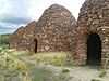
| 1 |
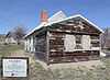
Bromide Charcoal Kilns |
|
02000-06-30-0000June 30, 2000
(#00000740) |
Off County Road 10
40°34′39″N 108°39′24″W / 40.5775°N 108.656667°W / 40.5775; -108.656667 (Bromide Charcoal Kilns) |
Greystone |
|
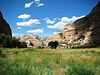
| 2 |
Castle Park Archeological District |
|
02006-01-03-0000January 3, 2006
(#06000055) |
Address Restricted
|
Dinosaur |
|
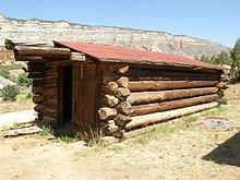
| 3 |
Rial Chew Ranch Complex |
|
01987-10-27-0000October 27, 1987
(#86003392) |
U.S. Highway 40
40°29′55″N 109°00′47″W / 40.498611°N 109.013056°W / 40.498611; -109.013056 (Rial Chew Ranch Complex) |
Dinosaur |
|
| 4 |
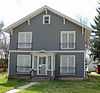
First National Bank Building |
|
01997-07-17-0000July 17, 1997
(#97000793) |
502-506 Yampa Ave.
40°30′52″N 107°32′49″W / 40.514444°N 107.546944°W / 40.514444; -107.546944 (First National Bank Building) |
Craig |
|
| 5 |
Denis Julien Inscription |
Upload image |
01986-12-19-0000December 19, 1986
(#86003395) |
U.S. Highway 40
40°32′43″N 109°00′55″W / 40.545278°N 109.015278°W / 40.545278; -109.015278 (Denis Julien Inscription) |
Dinosaur |
|
| 6 |
Lay School |
|
02013-03-20-0000March 20, 2013
(#13000080) |
7 Eddy Ave.
40°31′39″N 107°52′55″W / 40.527501°N 107.881897°W / 40.527501; -107.881897 (Lay School) |
Lay |
|
| 7 |
Mantle's Cave |
Upload image |
01994-05-10-0000May 10, 1994
(#94000394) |
Dinosaur National Monument
40°28′00″N 108°54′04″W / 40.466667°N 108.901111°W / 40.466667; -108.901111 (Mantle's Cave) |
Dinosaur |
|
| 8 |
Marcia (Pullman car) |
|
01975-06-20-0000June 20, 1975
(#75000526) |
341 E. Victory Way
40°30′51″N 107°32′32″W / 40.514167°N 107.542222°W / 40.514167; -107.542222 (Marcia (Pullman car)) |
Craig |
|
| 9 |
Old Ladore School |
Upload image |
01975-02-24-0000February 24, 1975
(#75000525) |
By the Green River on State Highway 318
40°46′48″N 108°53′32″W / 40.78°N 108.892222°W / 40.78; -108.892222 (Old Ladore School) |
Brown's Park |
|
| 10 |
State Armory |
|
01992-06-25-0000June 25, 1992
(#92000810) |
590 Yampa Ave.
40°30′57″N 107°32′49″W / 40.515833°N 107.546944°W / 40.515833; -107.546944 (State Armory) |
Craig |
Now the Museum of Northwest Colorado.
|
| 11 |
Two-Bar Ranch |
Upload image |
01978-02-17-0000February 17, 1978
(#78000873) |
West of Maybell off State Highway 318
40°47′12″N 108°53′38″W / 40.786667°N 108.893889°W / 40.786667; -108.893889 (Two-Bar Ranch) |
Maybell |
|
| 12 |
Upper Wade and Curtis Cabin |
|
01986-12-19-0000December 19, 1986
(#86003399) |
U.S. Highway 40
40°43′38″N 108°52′33″W / 40.727222°N 108.875833°W / 40.727222; -108.875833 (Upper Wade and Curtis Cabin) |
Dinosaur |
|
| 13 |
Vanatta Apartments |
|
01996-01-11-0000January 11, 1996
(#95001511) |
660 Yampa Ave.
40°31′02″N 107°32′49″W / 40.517222°N 107.546944°W / 40.517222; -107.546944 (Vanatta Apartments) |
Craig |
|
| 14 |
White-Indian Contact Site |
Upload image |
01977-03-08-0000March 8, 1977
(#77001561) |
Address Restricted
|
Sparks |
|
See also
References
- ↑ The latitude and longitude information provided in this table was derived originally from the National Register Information System, which has been found to be fairly accurate for about 99% of listings. For about 1% of NRIS original coordinates, experience has shown that one or both coordinates are typos or otherwise extremely far off; some corrections may have been made. A more subtle problem causes many locations to be off by up to 150 yards, depending on location in the country: most NRIS coordinates were derived from tracing out latitude and longitudes off of USGS topographical quadrant maps created under the North American Datum of 1927, which differs from the current, highly accurate WGS84 GPS system used by most on-line maps. Chicago is about right, but NRIS longitudes in Washington are higher by about 4.5 seconds, and are lower by about 2.0 seconds in Maine. Latitudes differ by about 1.0 second in Florida. Some locations in this table may have been corrected to current GPS standards.
- ↑ "National Register of Historic Places: Weekly List Actions". National Park Service, United States Department of the Interior. Retrieved on May 1, 2015.
- ↑ Numbers represent an ordering by significant words. Various colorings, defined here, differentiate National Historic Landmarks and historic districts from other NRHP buildings, structures, sites or objects.
- ↑ "National Register Information System". National Register of Historic Places. National Park Service. 2008-04-24.
- ↑ The eight-digit number below each date is the number assigned to each location in the National Register Information System database, which can be viewed by clicking the number.
|
|---|
| | Topics | |
|---|
| | Lists by states | |
|---|
| | Lists by insular areas | |
|---|
| | Lists by associated states | |
|---|
| | Other areas | |
|---|
|
-
 Category Category
-
 Portal Portal
-
 WikiProject WikiProject
|
|
.JPG)
.JPG)
.JPG)