National Register of Historic Places listings in Mitchell County, Kansas
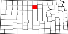
Location of Mitchell County in Kansas
This is a list of the National Register of Historic Places listings in Mitchell County, Kansas.
This is intended to be a complete list of the properties and districts on the National Register of Historic Places in Mitchell County, Kansas, United States. The locations of National Register properties and districts for which the latitude and longitude coordinates are included below, may be seen in a Google map.[1]
There are 13 properties and districts listed on the National Register in the county.
- This National Park Service list is complete through NPS recent listings posted May 1, 2015.[2]
Current listings
| [3] | Name on the Register[4] | Image | Date listed[5] | Location | City or town | Description |
|---|---|---|---|---|---|---|
| 1 | Antelope Creek Masonry Arch Bridge | Upload image | (#14000437) |
1000 mi. of Cty. Rd. 210 Coordinates missing |
Tipton | |
| 2 | Brown's Creek Tributary Masonry Arch Bridge | Upload image | (#14000438) |
2300 mi. on Cty. Rd. B Coordinates missing |
Glen Elder | |
| 3 | Cather Farm | |
(#07000611) |
4 miles north of the junction of K-15 and K-24 39°32′27″N 98°06′55″W / 39.540834°N 98.115391°W |
Beloit | |
| 4 | Abram Click Farmstead | 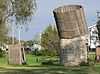 |
(#13000432) |
2030 Independence Avenue 39°28′51″N 98°06′59″W / 39.48084°N 98.11642°W |
Beloit | |
| 5 | E. W. Norris Service Station | 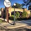 |
(#76000832) |
Market and Main Sts. 39°29′56″N 98°18′24″W / 39.498889°N 98.306667°W |
Glen Elder | |
| 6 | F. H. Hart House | _from_SSW_1.JPG) |
(#73000769) |
304 E. Main St. 39°27′31″N 98°06′26″W / 39.458686°N 98.107235°W |
Beloit | |
| 7 | Mitchell County Courthouse | 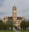 |
(#77000591) |
Main St. and Hersey Ave. 39°27′31″N 98°06′30″W / 39.458649°N 98.108463°W |
Beloit | |
| 8 | North Rock Creek Masonry Arch Bridge | Upload image | (#14000439) |
V Rd., .4 mi. E. of 190th Rd. Coordinates missing |
Hunter | |
| 9 | Old Cawker City Library | 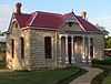 |
(#73000770) |
7th and Lake Sts. 39°30′39″N 98°25′58″W / 39.510806°N 98.432839°W |
Cawker City | |
| 10 | C. A. Perdue House | 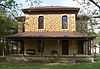 |
(#76000831) |
422 W. 8th St. 39°28′01″N 98°06′56″W / 39.467003°N 98.115582°W |
Beloit | |
| 11 | Porter Hotel | _from_SW_1.JPG) |
(#04000725) |
209 E. Main St. 39°27′33″N 98°06′30″W / 39.459275°N 98.108342°W |
Beloit | |
| 12 | St. John the Baptist Catholic Church | _from_SSW_2.JPG) |
(#75000717) |
701 E. Court St. 39°27′31″N 98°06′09″W / 39.458595°N 98.102369°W |
Beloit | |
| 13 | Wisconsin Street Historic District | 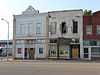 |
(#86001324) |
700 block of Wisconsin St. 39°30′37″N 98°25′58″W / 39.510278°N 98.432778°W |
Cawker City |
See also
| Wikimedia Commons has media related to National Register of Historic Places in Mitchell County, Kansas. |
- List of National Historic Landmarks in Kansas
- National Register of Historic Places listings in Kansas
References
- ↑ The latitude and longitude information provided in this table was derived originally from the National Register Information System, which has been found to be fairly accurate for about 99% of listings. For about 1% of NRIS original coordinates, experience has shown that one or both coordinates are typos or otherwise extremely far off; some corrections may have been made. A more subtle problem causes many locations to be off by up to 150 yards, depending on location in the country: most NRIS coordinates were derived from tracing out latitude and longitudes off of USGS topographical quadrant maps created under the North American Datum of 1927, which differs from the current, highly accurate WGS84 GPS system used by most on-line maps. Chicago is about right, but NRIS longitudes in Washington are higher by about 4.5 seconds, and are lower by about 2.0 seconds in Maine. Latitudes differ by about 1.0 second in Florida. Some locations in this table may have been corrected to current GPS standards.
- ↑ "National Register of Historic Places: Weekly List Actions". National Park Service, United States Department of the Interior. Retrieved on May 1, 2015.
- ↑ Numbers represent an ordering by significant words. Various colorings, defined here, differentiate National Historic Landmarks and historic districts from other NRHP buildings, structures, sites or objects.
- ↑ "National Register Information System". National Register of Historic Places. National Park Service. 2009-03-13.
- ↑ The eight-digit number below each date is the number assigned to each location in the National Register Information System database, which can be viewed by clicking the number.


| |||||||||||||||||||||||||||||