National Register of Historic Places listings in Mitchell County, Iowa

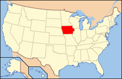
Location of Mitchell County in Iowa
This is a list of the National Register of Historic Places listings in Mitchell County, Iowa.
This is intended to be a complete list of the properties and districts on the National Register of Historic Places in Mitchell County, Iowa, United States. Latitude and longitude coordinates are provided for many National Register properties and districts; these locations may be seen together in a Google map.[1]
There are 10 properties and districts listed on the National Register in the county.
- This National Park Service list is complete through NPS recent listings posted May 1, 2015.[2]
| [3] |
Name on the Register[4] |
Image |
Date listed[5] |
Location |
City or town |
Description |
|---|
| 1 |
Cedar Valley Seminary |
Upload image |
01977-11-17-0000November 17, 1977
(#77000541) |
N. 6th and Mechanic Sts.
43°17′10″N 92°48′49″W / 43.286111°N 92.813611°W / 43.286111; -92.813611 (Cedar Valley Seminary) |
Osage |
|
| 2 |
Nathaniel Cobb and Lucetia Baily Deering House |
Upload image |
02001-01-26-0000January 26, 2001
(#00001678) |
903 State St.
43°17′04″N 92°48′49″W / 43.284444°N 92.813611°W / 43.284444; -92.813611 (Nathaniel Cobb and Lucetia Baily Deering House) |
Osage |
|
| 3 |
First Lutheran Church |
Upload image |
01976-12-12-0000December 12, 1976
(#76000795) |
212 N. Main St.
43°22′48″N 92°55′32″W / 43.38°N 92.925556°W / 43.38; -92.925556 (First Lutheran Church) |
St. Ansgar |
|
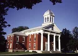
| 4 |
Mitchell County Courthouse |
|
01977-08-29-0000August 29, 1977
(#77000542) |
500 State St.
43°16′57″N 92°48′50″W / 43.2825°N 92.813889°W / 43.2825; -92.813889 (Mitchell County Courthouse) |
Osage |
|
| 5 |
Mitchell Powerhouse and Dam |
Upload image |
01978-12-08-0000December 8, 1978
(#78001246) |
Red Cedar River
43°19′06″N 92°52′51″W / 43.318333°N 92.880833°W / 43.318333; -92.880833 (Mitchell Powerhouse and Dam) |
Mitchell |
|
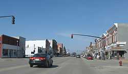
| 6 |
Osage Commercial Historic District |
|
02002-09-12-0000September 12, 2002
(#02001030) |
700, 600, and parts of the 500 blocks of Main St.
43°17′02″N 92°48′40″W / 43.283889°N 92.811111°W / 43.283889; -92.811111 (Osage Commercial Historic District) |
Osage |
|
| 7 |
Otranto Bridge |
Upload image |
01998-05-15-0000May 15, 1998
(#98000495) |
480th Ave. over the Big Cedar River
43°27′29″N 92°58′55″W / 43.458056°N 92.981944°W / 43.458056; -92.981944 (Otranto Bridge) |
St. Ansgar |
|
| 8 |
Nels Severson Barn |
Upload image |
01977-07-15-0000July 15, 1977
(#77000540) |
North of Carpenter
43°25′21″N 93°00′40″W / 43.4225°N 93.011111°W / 43.4225; -93.011111 (Nels Severson Barn) |
Carpenter |
|
| 9 |
Union Presbyterian Church |
Upload image |
01977-04-13-0000April 13, 1977
(#77000543) |
Northwest of Stacyville
43°28′47″N 92°48′35″W / 43.479722°N 92.809722°W / 43.479722; -92.809722 (Union Presbyterian Church) |
Stacyville |
|
| 10 |
Walnut Grove School |
Upload image |
02002-09-12-0000September 12, 2002
(#02001028) |
3272 Foothill Ave.
43°13′47″N 92°55′10″W / 43.229722°N 92.919444°W / 43.229722; -92.919444 (Walnut Grove School) |
Osage |
|
See also
References
- ↑ The latitude and longitude information provided in this table was derived originally from the National Register Information System, which has been found to be fairly accurate for about 99% of listings. For about 1% of NRIS original coordinates, experience has shown that one or both coordinates are typos or otherwise extremely far off; some corrections may have been made. A more subtle problem causes many locations to be off by up to 150 yards, depending on location in the country: most NRIS coordinates were derived from tracing out latitude and longitudes off of USGS topographical quadrant maps created under the North American Datum of 1927, which differs from the current, highly accurate WGS84 GPS system used by most on-line maps. Chicago is about right, but NRIS longitudes in Washington are higher by about 4.5 seconds, and are lower by about 2.0 seconds in Maine. Latitudes differ by about 1.0 second in Florida. Some locations in this table may have been corrected to current GPS standards.
- ↑ "National Register of Historic Places: Weekly List Actions". National Park Service, United States Department of the Interior. Retrieved on May 1, 2015.
- ↑ Numbers represent an ordering by significant words. Various colorings, defined here, differentiate National Historic Landmarks and historic districts from other NRHP buildings, structures, sites or objects.
- ↑ "National Register Information System". National Register of Historic Places. National Park Service. 2008-04-24.
- ↑ The eight-digit number below each date is the number assigned to each location in the National Register Information System database, which can be viewed by clicking the number.
|
|---|
| | Topics | |
|---|
| | Lists by states | |
|---|
| | Lists by insular areas | |
|---|
| | Lists by associated states | |
|---|
| | Other areas | |
|---|
|
-
 Category Category
-
 Portal Portal
-
 WikiProject WikiProject
|
|
|
|---|
| | | | Cities | | |
|---|
| | Townships | |
|---|
| | CDPs | |
|---|
| | Footnotes | ‡This populated place also has portions in an adjacent county or counties |
|---|
|