National Register of Historic Places listings in Mifflin County, Pennsylvania

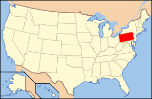
Location of Mifflin County in Pennsylvania
This is a list of the National Register of Historic Places listings in Mifflin County, Pennsylvania.
This is intended to be a complete list of the properties on the National Register of Historic Places in Mifflin County, Pennsylvania, United States. The locations of National Register properties and districts for which the latitude and longitude coordinates are included below, may be seen in a Google map.[1]
There are 9 properties listed on the National Register in the county.
- This National Park Service list is complete through NPS recent listings posted May 1, 2015.[2]
Current listings
| [3] |
Name on the Register |
Image |
Date listed[4] |
Location |
City or town |
Description |
|---|
| 1 |
Embassy Theatre |
|
01998-07-23-0000July 23, 1998
(#98000899) |
6 South Main Street
40°35′49″N 77°34′34″W / 40.596944°N 77.576111°W / 40.596944; -77.576111 (Embassy Theatre) |
Lewistown |
Vaudeville and movie theater built in 1927.
|
| 2 |
Lewistown Armory |
|
01991-05-09-0000May 9, 1991
(#91000513) |
1101 Walnut Street
40°37′08″N 77°33′06″W / 40.618889°N 77.551667°W / 40.618889; -77.551667 (Lewistown Armory) |
Derry Township |
Armory built in 1938 in the Colonial Revival style.
|
| 3 |
McCoy House |
|
01973-03-14-0000March 14, 1973
(#73001641) |
17 North Main Street
40°35′53″N 77°34′31″W / 40.598056°N 77.575278°W / 40.598056; -77.575278 (McCoy House) |
Lewistown |
House built between 1836 and 1843; birthplace of Frank Ross McCoy
|
| 4 |
Mifflin County Courthouse |
|
01976-05-28-0000May 28, 1976
(#76001649) |
1 West Market Street
40°35′51″N 77°34′32″W / 40.5975°N 77.575556°W / 40.5975; -77.575556 (Mifflin County Courthouse) |
Lewistown |
Courthouse built in 1842-1843, and expanded in 1878.
|
| 5 |
Montgomery Ward Building |
|
01984-09-07-0000September 7, 1984
(#84003497) |
3–7 West Market Street
40°35′54″N 77°34′25″W / 40.598333°N 77.573611°W / 40.598333; -77.573611 (Montgomery Ward Building) |
Lewistown |
Art Deco department store and office building built in 1929.
|
| 6 |
Old Hoopes School |
|
01978-12-20-0000December 20, 1978
(#78002431) |
Northeast of Lewistown
40°38′24″N 77°30′25″W / 40.64°N 77.506944°W / 40.64; -77.506944 (Old Hoopes School) |
Derry Township |
One-room school built in 1873.
|
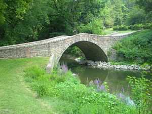
| 7 |
Old Stone Arch Bridge |
|
01979-04-18-0000April 18, 1979
(#09000096) |
Over Jack's Creek, southeast of Lewistown
40°35′04″N 77°33′23″W / 40.584444°N 77.556389°W / 40.584444; -77.556389 (Old Stone Arch Bridge) |
Derry Township |
|
| 8 |
Pennsylvania Main Line Canal, Juniata Division, Canal Section |
|
02002-02-20-0000February 20, 2002
(#02000069) |
1.5 miles (2.4 km) section of canal between the Main Line of the Pennsylvania Railroad and the Juniata River
40°33′52″N 77°35′29″W / 40.564444°N 77.591389°W / 40.564444; -77.591389 (Pennsylvania Main Line Canal, Juniata Division, Canal Section) |
Granville Township |
Historic canal segment.
|
| 9 |
Wollner Building |
|
01984-08-23-0000August 23, 1984
(#84003499) |
16 West Market Street
40°35′54″N 77°34′25″W / 40.598333°N 77.573611°W / 40.598333; -77.573611 (Wollner Building) |
Lewistown |
Brick commercial building built in 1906. |
See also
References
- ↑ The latitude and longitude information provided in this table was derived originally from the National Register Information System, which has been found to be fairly accurate for about 99% of listings. For about 1% of NRIS original coordinates, experience has shown that one or both coordinates are typos or otherwise extremely far off; some corrections may have been made. A more subtle problem causes many locations to be off by up to 150 yards, depending on location in the country: most NRIS coordinates were derived from tracing out latitude and longitudes off of USGS topographical quadrant maps created under the North American Datum of 1927, which differs from the current, highly accurate WGS84 GPS system used by most on-line maps. Chicago is about right, but NRIS longitudes in Washington are higher by about 4.5 seconds, and are lower by about 2.0 seconds in Maine. Latitudes differ by about 1.0 second in Florida. Some locations in this table may have been corrected to current GPS standards.
- ↑ "National Register of Historic Places: Weekly List Actions". National Park Service, United States Department of the Interior. Retrieved on May 1, 2015.
- ↑ Numbers represent an ordering by significant words. Various colorings, defined here, differentiate National Historic Landmarks and historic districts from other NRHP buildings, structures, sites or objects.
- ↑ The eight-digit number below each date is the number assigned to each location in the National Register Information System database, which can be viewed by clicking the number.
|
|---|
| | Topics | | |
|---|
| | Lists by county | |
|---|
| | Lists by city | |
|---|
| | Other lists | |
|---|
|
-
 Category Category
-
 NRHP portal NRHP portal
|
|