| [3] |
Name on the Register |
Image |
Date listed[4] |
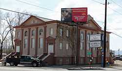
Location |
City or town |
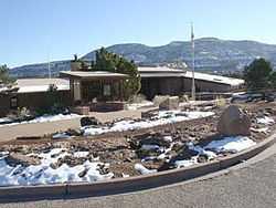
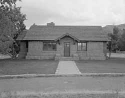
Description |
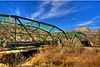
|---|
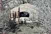
| 1 |
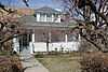
Bloomfield Site |
|
01983-01-20-0000January 20, 1983
(#83001324) |
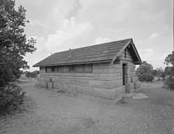
Address Restricted
|
Whitewater |
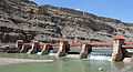
|
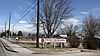
| 2 |
Calamity Camp |
|
02011-06-01-0000June 1, 2011
(#11000313) |
Address Restricted
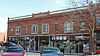
|
Gateway vicinity |
Mining Industry in Colorado MPS
|
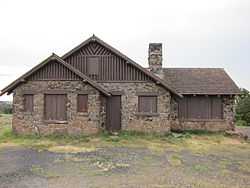
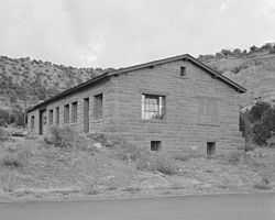
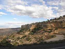
| 3 |
Cayton Guard Station |
Upload image |
02005-04-27-0000April 27, 2005
(#05000335) |
Forest Service Road 814.1
39°18′20″N 107°33′51″W / 39.305556°N 107.564167°W / 39.305556; -107.564167 (Cayton Guard Station) |
Silt |
|
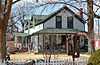
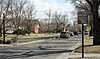
| 4 |
Clifton Community Center and Church |
|
01982-06-03-0000June 3, 1982
(#82002307) |
F and Front St.
39°05′29″N 108°26′57″W / 39.091389°N 108.449167°W / 39.091389; -108.449167 (Clifton Community Center and Church) |
Clifton |
|
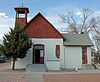
| 5 |
Coates Creek Schoolhouse |
Upload image |
01993-02-03-0000February 3, 1993
(#92001839) |
D S Rd., 16 miles (26 km) west of Glade Park
38°56′55″N 108°58′32″W / 38.948611°N 108.975556°W / 38.948611; -108.975556 (Coates Creek Schoolhouse) |
Glade Park |
|
| 6 |
Colorado National Monument Visitor Center Complex |
|
02003-07-15-0000July 15, 2003
(#03000647) |
Colorado National Monument
39°06′07″N 108°43′50″W / 39.101944°N 108.730556°W / 39.101944; -108.730556 (Colorado National Monument Visitor Center Complex) |
Fruita |
|
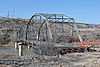
| 7 |
Colorado River Bridge |
|
02002-10-15-0000October 15, 2002
(#02001154) |
Interstate 70 frontage road at milepost 62.90
39°20′20″N 108°11′36″W / 39.338889°N 108.193333°W / 39.338889; -108.193333 (Colorado River Bridge) |
De Beque |
|
| 8 |
Convicts' Bread Oven |
|
01974-12-31-0000December 31, 1974
(#74000589) |
West of Molina on State Highway 65
39°12′02″N 108°11′29″W / 39.200556°N 108.191389°W / 39.200556; -108.191389 (Convicts' Bread Oven) |
Molina |
|
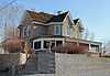
| 9 |
Herbert and Edith Crissey House |
|
02003-05-18-0000May 18, 2003
(#03000402) |
218 W. 1st St.
39°06′44″N 108°21′07″W / 39.112222°N 108.351944°W / 39.112222; -108.351944 (Herbert and Edith Crissey House) |
Palisade |
|
| 10 |
Cross Land and Fruit Company Orchards and Ranch |
|
01980-03-28-0000March 28, 1980
(#80000912) |
Northeast of Grand Junction at 3079 F Rd.
39°05′28″N 108°28′52″W / 39.091111°N 108.481111°W / 39.091111; -108.481111 (Cross Land and Fruit Company Orchards and Ranch) |
Grand Junction |
|
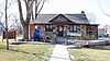
| 11 |
De Beque House |
|
01995-07-28-0000July 28, 1995
(#95000936) |
233 Denver Ave.
39°19′49″N 108°13′04″W / 39.330278°N 108.217778°W / 39.330278; -108.217778 (De Beque House) |
De Beque |
|
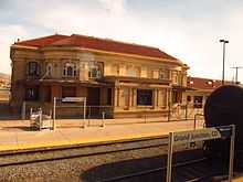
| 12 |
Denver and Rio Grande Western Railroad Depot |
|
01992-09-08-0000September 8, 1992
(#92001190) |
119 Pitkin Ave.
39°03′51″N 108°34′09″W / 39.064167°N 108.569167°W / 39.064167; -108.569167 (Denver and Rio Grande Western Railroad Depot) |
Grand Junction |
|
| 13 |
Devils Kitchen Picnic Shelter |
|
01994-04-21-0000April 21, 1994
(#94000309) |
Colorado National Monument
39°01′58″N 108°37′59″W / 39.032778°N 108.633056°W / 39.032778; -108.633056 (Devils Kitchen Picnic Shelter) |
Grand Junction |
|
| 14 |
Fruita Bridge |
|
01985-02-04-0000February 4, 1985
(#85000218) |
17 1/2 Rd over the Colorado River
39°08′13″N 108°43′50″W / 39.136944°N 108.730556°W / 39.136944; -108.730556 (Fruita Bridge) |
Fruita |
|
| 15 |
Fruita Museum |
|
01996-10-10-0000October 10, 1996
(#96001080) |
432 E. Aspen
39°08′59″N 108°43′45″W / 39.149722°N 108.729167°W / 39.149722; -108.729167 (Fruita Museum) |
Fruita |
|
| 16 |
Grand Valley Diversion Dam |
|
01991-10-08-0000October 8, 1991
(#91001485) |
Across the Colorado River north of its confluence with Plateau Creek, 8 miles (13 km) northeast of Palisade
39°11′20″N 108°16′53″W / 39.188889°N 108.281389°W / 39.188889; -108.281389 (Grand Valley Diversion Dam) |
Palisade |
|
| 17 |
Handy Chapel |
|
01994-08-19-0000August 19, 1994
(#94001012) |
202 White Ave.
39°04′10″N 108°34′07″W / 39.069444°N 108.568611°W / 39.069444; -108.568611 (Handy Chapel) |
Grand Junction |
|
| 18 |
Hotel St. Regis |
|
01992-10-22-0000October 22, 1992
(#92001410) |
359 Colorado Ave.
39°03′58″N 108°33′56″W / 39.066111°N 108.565556°W / 39.066111; -108.565556 (Hotel St. Regis) |
Grand Junction |
|
| 19 |
IOOF Hall |
|
01993-03-25-0000March 25, 1993
(#93000200) |
Junction of 4th St. and Curtis Ave.
39°20′00″N 108°12′51″W / 39.333333°N 108.214167°W / 39.333333; -108.214167 (IOOF Hall) |
De Beque |
|
| 20 |
Kettle-Jens House |
|
01983-05-06-0000May 6, 1983
(#83001325) |
498 32 Rd.
39°04′37″N 108°27′31″W / 39.076944°N 108.458611°W / 39.076944; -108.458611 (Kettle-Jens House) |
Clifton |
|
| 21 |
Land's End Observatory |
|
01997-02-28-0000February 28, 1997
(#97000124) |
Land's End Rd., 10 miles (16 km) west of State Highway 65
39°01′30″N 108°13′25″W / 39.025°N 108.223611°W / 39.025; -108.223611 (Land's End Observatory) |
Whitewater |
|
| 22 |
Loma Community Hall |
Upload image |
01995-11-22-0000November 22, 1995
(#95001338) |
1341 13 Road
39°11′56″N 108°48′47″W / 39.198889°N 108.813056°W / 39.198889; -108.813056 (Loma Community Hall) |
Loma |
|
| 23 |
Margery Building |
|
01993-02-24-0000February 24, 1993
(#93000033) |
519-527 Main St.
39°04′02″N 108°33′48″W / 39.067222°N 108.563333°W / 39.067222; -108.563333 (Margery Building) |
Grand Junction |
|
| 24 |
North Seventh Street Historic Residential District |
|
01984-01-05-0000January 5, 1984
(#84000870) |
7th St. between Hill and White Aves.
39°04′19″N 108°33′37″W / 39.071944°N 108.560278°W / 39.071944; -108.560278 (North Seventh Street Historic Residential District) |
Grand Junction |
|
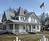
| 25 |
Harry and Lilly Phillips House |
|
01997-11-13-0000November 13, 1997
(#97001419) |
798 N. Mesa St.
39°10′21″N 108°43′58″W / 39.1725°N 108.732778°W / 39.1725; -108.732778 (Harry and Lilly Phillips House) |
Fruita |
|
| 26 |
Pipe Line School |
Upload image |
01999-04-29-0000April 29, 1999
(#99000483) |
101 16.5 S Rd.
38°59′50″N 108°44′27″W / 38.997222°N 108.740833°W / 38.997222; -108.740833 (Pipe Line School) |
Glade Park |
|
| 27 |
Rim Rock Drive Historic District |
|
01994-04-21-0000April 21, 1994
(#94000310) |
Colorado National Monument
39°03′25″N 108°42′04″W / 39.056944°N 108.701111°W / 39.056944; -108.701111 (Rim Rock Drive Historic District) |
Grand Junction |
|
| 28 |
Saddlehorn Caretaker's House and Garage |
|
01994-04-21-0000April 21, 1994
(#94000306) |
Colorado National Monument
39°06′05″N 108°43′59″W / 39.101389°N 108.733056°W / 39.101389; -108.733056 (Saddlehorn Caretaker's House and Garage) |
Grand Junction |
|
| 29 |
Saddlehorn Comfort Station |
|
01994-04-21-0000April 21, 1994
(#94000305) |
Colorado National Monument
39°06′17″N 108°44′23″W / 39.104722°N 108.739722°W / 39.104722; -108.739722 (Saddlehorn Comfort Station) |
Grand Junction |
|
| 30 |
Saddlehorn Utility Area Historic District |
|
01994-04-21-0000April 21, 1994
(#94000308) |
Colorado National Monument
39°06′05″N 108°44′17″W / 39.101389°N 108.738056°W / 39.101389; -108.738056 (Saddlehorn Utility Area Historic District) |
Grand Junction |
|
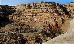
| 31 |
Serpents Trail |
|
01994-04-21-0000April 21, 1994
(#94000307) |
Colorado National Monument
39°01′53″N 108°38′11″W / 39.031389°N 108.636389°W / 39.031389; -108.636389 (Serpents Trail) |
Grand Junction |
|
| 32 |
Stranges Grocery |
Upload image |
02013-03-20-0000March 20, 2013
(#13000079) |
226 Pitkin Ave.
39°03′53″N 108°34′08″W / 39.064748°N 108.568786°W / 39.064748; -108.568786 (Stranges Grocery) |
Grand Junction |
|
| 33 |
U.S. Post Office |
|
01980-01-31-0000January 31, 1980
(#80000913) |
400 Rood Ave.
39°04′07″N 108°33′55″W / 39.068611°N 108.565278°W / 39.068611; -108.565278 (U.S. Post Office) |
Grand Junction |
|

.JPG)
.JPG)
.JPG)
