National Register of Historic Places listings in Medina County, Ohio
Coordinates: 41°08′10″N 81°51′55″W / 41.136086°N 81.865303°W

Location of Medina County in Ohio
This is a list of the National Register of Historic Places listings in Medina County, Ohio.
This is intended to be a complete list of the properties and districts on the National Register of Historic Places in Medina County, Ohio, United States. The locations of National Register properties and districts for which the latitude and longitude coordinates are included below, may be seen in a Google map.[1]
There are 28 properties and districts listed on the National Register in the county. Another property was once listed but has been removed.
- This National Park Service list is complete through NPS recent listings posted May 1, 2015.[2]
Current listings
| [3] | Name on the Register[4] | Image | Date listed[5] | Location | City or town | Description |
|---|---|---|---|---|---|---|
| 1 | Black River Viaduct, Baltimore and Ohio Railroad | 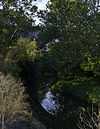 |
(#76001488) |
1 mi (1.6 km) west of Lodi off State Route 421 41°01′38″N 82°02′29″W / 41.027222°N 82.041389°W |
Harrisville Township | |
| 2 | H.G. Blake House | 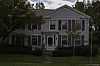 |
(#82003612) |
314 E. Washington St. 41°08′16″N 81°51′36″W / 41.137778°N 81.860000°W |
Medina | |
| 3 | Burritt Blakslee House | 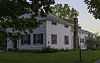 |
(#74001573) |
3756 Fenn Rd., northeast of Medina 41°10′14″N 81°49′17″W / 41.170556°N 81.821389°W |
Medina Township | |
| 4 | George Burr House | 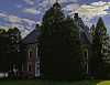 |
(#76001489) |
740 Wooster Rd. 41°01′29″N 81°59′50″W / 41.024722°N 81.997222°W |
Lodi | |
| 5 | Matthew Chandler House | 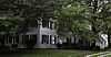 |
(#78002134) |
South of Sharon Center at 6908 Ridge Rd. 41°05′11″N 81°44′10″W / 41.086389°N 81.736111°W |
Sharon Township | |
| 6 | Zimri Cook House | 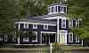 |
(#76001487) |
6999 Spieth Rd. in Lester 41°10′52″N 81°56′24″W / 41.181111°N 81.94°W |
York Township | |
| 7 | Charles Frank House and Store | _1.jpg) |
(#75001485) |
West of Valley City at the junction of State Route 303 and County Route 23 41°14′14″N 81°57′15″W / 41.237222°N 81.954167°W |
Liverpool Township | |
| 8 | Jacob Gayer House | 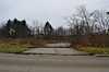 |
(#79001894) |
North of Medina at 4508 Marks Rd. 41°09′08″N 81°52′43″W / 41.152222°N 81.878611°W |
Medina Township | |
| 9 | Halsey Hulburt Homestead | 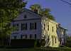 |
(#88002747) |
5484 Seville Rd., west of Seville 41°00′41″N 81°53′13″W / 41.011389°N 81.886944°W |
Guilford Township | |
| 10 | King-Phillips-Deibel House | 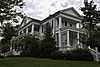 |
(#82001472) |
506 N. Broadway St. 41°08′40″N 81°51′45″W / 41.144444°N 81.8625°W |
Medina | |
| 11 | Medfair Heights Apartment Historic District | 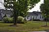 |
(#08000624) |
221 N. State St. 41°08′28″N 81°52′47″W / 41.141111°N 81.879722°W |
Medina | |
| 12 | Medina County Courthouse |  |
(#70000507) |
Liberty St. and Broadway, Public Sq. 41°08′20″N 81°51′45″W / 41.138889°N 81.8625°W |
Medina | |
| 13 | Medina Masonic Temple and Medina Theater | 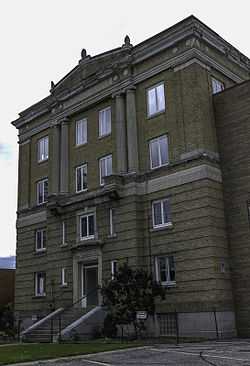 |
(#02001210) |
120 N. Elmwood Ave. and 139 W. Liberty St. 41°08′23″N 81°51′56″W / 41.139722°N 81.865556°W |
Medina | |
| 14 | Medina Public Square Historic District |  |
(#75001483) |
Public Sq. and surrounding properties 41°08′19″N 81°51′49″W / 41.138611°N 81.863611°W |
Medina | |
| 15 | Judge Albert Munson House | 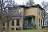 |
(#80003156) |
141 S. Prospect St.[6] 41°08′18″N 81°52′17″W / 41.138472°N 81.871250°W |
Medina | Previously located at 231 E. Washington St.;[4] relocated to prevent destruction[6] |
| 16 | Paleo Crossing Site | 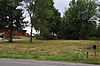 |
(#92000972) |
Northwest of the junction of Ridgewood and State Rds.[7] 41°07′20″N 81°43′13″W / 41.1222°N 81.72034°W |
Sharon Township | |
| 17 | Parmelee House | 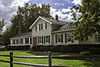 |
(#79001895) |
1328 W. River Rd. in Valley City 41°14′18″N 81°55′51″W / 41.238333°N 81.930833°W |
Liverpool Township | |
| 18 | A.I. and E.R. Root Homestead | 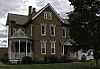 |
(#75001484) |
662 W. Liberty St. 41°08′20″N 81°52′29″W / 41.138889°N 81.874722°W |
Medina | |
| 19 | St. Mark's Episcopal Church | 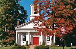 |
(#73001506) |
146 College St. 41°01′33″N 81°43′53″W / 41.025833°N 81.731389°W |
Wadsworth | |
| 20 | St. Martin's Catholic Church | _1.jpg) |
(#75001486) |
Southwest of Valley City on Station Rd. (County Road 23) 41°13′30″N 81°57′18″W / 41.225°N 81.955°W |
Liverpool Township | |
| 21 | St. Paul's Episcopal Church | 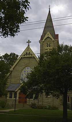 |
(#82003613) |
317 E. Liberty St. 41°08′22″N 81°51′38″W / 41.139444°N 81.860556°W |
Medina | |
| 22 | Seville Jail |  |
(#97001135) |
70 W. Main St. 41°00′37″N 81°52′00″W / 41.010278°N 81.866667°W |
Seville | |
| 23 | William H. Seymour House |  |
(#79001896) |
3306 S. Weymouth Rd. at Weymouth 41°11′07″N 81°47′41″W / 41.185278°N 81.794722°W |
Medina Township | |
| 24 | Sharon Center Public Square Historic District | 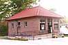 |
(#80003157) |
State Routes State Route 94 and 162 in Sharon Center 41°05′57″N 81°44′09″W / 41.099167°N 81.735833°W |
Sharon Township | |
| 25 | Spring Grove Cemetery | 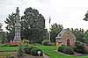 |
(#06000482) |
Spring Grove St. 41°08′22″N 81°51′06″W / 41.139444°N 81.851667°W |
Medina | |
| 26 | Universalist Church Of Westfield Center | 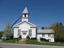 |
(#78002135) |
LeRoy and Greenwich Rds. 41°01′39″N 81°55′59″W / 41.0275°N 81.933056°W |
Westfield Center | |
| 27 | Wheeling and Lake Erie Railroad Depot | 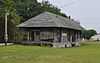 |
(#12001215) |
204 Railroad St. 41°01′50″N 82°00′46″W / 41.030556°N 82.012778°W |
Lodi | |
| 28 | York United Methodist Church | 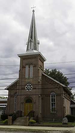 |
(#78002133) |
Norwalk Rd. in Mallet Creek 41°10′01″N 81°55′29″W / 41.166944°N 81.924722°W |
York Township |
Former listing
| [3] | Name on the Register | Image | Date listed | Date removed | Location | City or town | Summary |
|---|---|---|---|---|---|---|---|
| 1 | Brunswick Town Hall and School | Upload image | (#75002167) | 1380 Pearl Rd. 41°14′19″N 81°50′30″W / 41.2386°N 81.8417°W |
York Township |
See also
| Wikimedia Commons has media related to National Register of Historic Places in Medina County, Ohio. |
References
- ↑ The latitude and longitude information provided in this table was derived originally from the National Register Information System, which has been found to be fairly accurate for about 99% of listings. For about 1% of NRIS original coordinates, experience has shown that one or both coordinates are typos or otherwise extremely far off; some corrections may have been made. A more subtle problem causes many locations to be off by up to 150 yards, depending on location in the country: most NRIS coordinates were derived from tracing out latitude and longitudes off of USGS topographical quadrant maps created under the North American Datum of 1927, which differs from the current, highly accurate WGS84 GPS system used by most on-line maps. Chicago is about right, but NRIS longitudes in Washington are higher by about 4.5 seconds, and are lower by about 2.0 seconds in Maine. Latitudes differ by about 1.0 second in Florida. Some locations in this table may have been corrected to current GPS standards.
- ↑ "National Register of Historic Places: Weekly List Actions". National Park Service, United States Department of the Interior. Retrieved on May 1, 2015.
- ↑ 3.0 3.1 Numbers represent an ordering by significant words. Various colorings, defined here, differentiate National Historic Landmarks and historic districts from other NRHP buildings, structures, sites or objects.
- ↑ 4.0 4.1 "National Register Information System". National Register of Historic Places. National Park Service. 2009-03-13.
- ↑ The eight-digit number below each date is the number assigned to each location in the National Register Information System database, which can be viewed by clicking the number.
- ↑ 6.0 6.1 Preserving Medina's Heritage, Medina Community Design Committee, n.d. Accessed 2013-09-09.
- ↑ Location derived from the Rose of Sharon Subdivision Preliminary Plan, Medina County Planning Commission, 2005-04-06. Accessed 2009-08-03. The NRIS lists the site as "Address Restricted".


| |||||||||||||||||||||||||||||