National Register of Historic Places listings in Meade County, South Dakota

Location of Meade County in South Dakota
This is a list of the National Register of Historic Places listings in Meade County, South Dakota.
This is intended to be a complete list of the properties and districts on the National Register of Historic Places in Meade County, South Dakota, United States. The locations of National Register properties and districts for which the latitude and longitude coordinates are included below, may be seen in a Google map.[1]
There are 27 properties and districts listed on the National Register in the county, including 1 National Historic Landmark.
- This National Park Service list is complete through NPS recent listings posted May 1, 2015.[2]
Current listings
| [3] | Name on the Register[4] | Image | Date listed[5] | Location | City or town | Description |
|---|---|---|---|---|---|---|
| 1 | Archeological Site No. 39MD20 | Upload image | (#93000798) |
Address Restricted |
Tilford | |
| 2 | Archeological Site No. 39MD81 | Upload image | (#93000818) |
Address Restricted |
Sturgis | |
| 3 | Archeological Site No. 39MD82 | Upload image | (#93000797) |
Address Restricted |
Sturgis | |
| 4 | Joseph Baker House | Upload image | (#86000942) |
County Road 19A Coordinates missing |
Hereford | |
| 5 | L.L. Bartlett House | Upload image | (#86000946) |
County Road 26 Coordinates missing |
Stoneville | |
| 6 | Bear Butte | 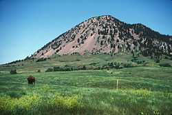 |
(#73001746) |
Northeast of Sturgis 44°28′25″N 103°25′33″W / 44.473611°N 103.425833°W |
Sturgis | |
| 7 | Bethel Lutheran Church | Upload image | (#86000941) |
Main and 5th Sts. 45°01′10″N 102°02′19″W / 45.019444°N 102.038611°W |
Faith | |
| 8 | Black Hawk Elementary School | Upload image | (#86000939) |
Main and Elm Sts. 44°09′04″N 103°18′35″W / 44.151111°N 103.309722°W |
Blackhawk | |
| 9 | Covered Wagon Resort | Upload image | (#07001213) |
14189 County Road 79 Coordinates missing |
Piedmont | |
| 10 | Erskine School | Upload image | (#84003354) |
Sherman St. 44°24′45″N 103°30′52″W / 44.4125°N 103.514444°W |
Sturgis | |
| 11 | John and Coralin Evans Ranch | Upload image | (#86000943) |
County Road 4 Coordinates missing |
Piedmont | |
| 12 | Fort Meade District | 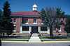 |
(#73001747) |
East of Sturgis on Highway 34 44°24′46″N 103°28′22″W / 44.412778°N 103.472778°W |
Sturgis | |
| 13 | Frozenman Stage Station | Upload image | (#92000691) |
Address Restricted |
Bison | |
| 14 | Stephen and Maria Graf House | Upload image | (#02001283) |
1233 Main St. 44°24′52″N 103°30′49″W / 44.414444°N 103.513611°W |
Sturgis | |
| 15 | H O Ranch Log House | Upload image | (#90000954) |
3 miles west of Marcus 44°39′49″N 102°20′10″W / 44.663611°N 102.336111°W |
Marcus | |
| 16 | Ole and Carris Johnson Ranch | Upload image | (#86000938) |
County Road 7 Coordinates missing |
Blackhawk | |
| 17 | Minneapolis Brewing Company Beer Warehouse | Upload image | (#01000100) |
Highway 212 45°01′24″N 102°02′07″W / 45.023333°N 102.035278°W |
Faith | |
| 18 | Municipal Building-City Hall | Upload image | (#00000722) |
206 Main St. 45°01′26″N 102°02′17″W / 45.023889°N 102.038056°W |
Faith | |
| 19 | Elias B. Olsen Ranch | Upload image | (#86000940) |
County Road 6 Coordinates missing |
Elm Springs | |
| 20 | Jacob and Elizabeth Raskob Ranch | Upload image | (#86000945) |
Highway 34 44°28′12″N 103°20′54″W / 44.47°N 103.348333°W |
Sturgis | |
| 21 | South Dakota Dept. of Transportation Bridge No. 47-151-389 | Upload image | (#93001263) |
Local road over Bear Butte Creek Coordinates missing |
Sturgis | |
| 22 | Stevens Ranch | Upload image | (#86000944) |
County Road 4 Coordinates missing |
Piedmont | |
| 23 | Stomprude Trail Ruts | Upload image | (#92000690) |
Address Restricted |
Bison | |
| 24 | Sturgis Commercial Block | Upload image | (#75001719) |
1000-1028 Main St. 44°24′50″N 103°30′33″W / 44.413889°N 103.509167°W |
Sturgis | |
| 25 | Sturgis High School | Upload image | (#00000998) |
1425 Cedar St. 44°24′35″N 103°31′16″W / 44.409722°N 103.521111°W |
Sturgis | |
| 26 | Annie Tallent House | 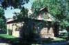 |
(#76001746) |
1603 Main St. 44°24′53″N 103°31′01″W / 44.414722°N 103.516944°W |
Sturgis | |
| 27 | John G. Wenke House | Upload image | (#76001747) |
1340 Junction Ave. 44°24′39″N 103°30′30″W / 44.410833°N 103.508333°W |
Sturgis |
Former listings
| [3] | Name on the Register | Image | Date listed | Date removed | Location | City or town | Summary |
|---|---|---|---|---|---|---|---|
| 1 | South Dakota Dept. of Transportation Bridge No. 47-215-363 | Upload image | (#93001303) | SD 34 over the Belle Fourche R. |
Sturgis vicinity | ||
| 2 | Poker Alice Tubbs House | Upload image | (#75001720) | N. Junction St. |
Sturgis |
See also
| Wikimedia Commons has media related to National Register of Historic Places in Meade County, South Dakota. |
- List of National Historic Landmarks in South Dakota
- National Register of Historic Places listings in South Dakota
References
- ↑ The latitude and longitude information provided in this table was derived originally from the National Register Information System, which has been found to be fairly accurate for about 99% of listings. For about 1% of NRIS original coordinates, experience has shown that one or both coordinates are typos or otherwise extremely far off; some corrections may have been made. A more subtle problem causes many locations to be off by up to 150 yards, depending on location in the country: most NRIS coordinates were derived from tracing out latitude and longitudes off of USGS topographical quadrant maps created under the North American Datum of 1927, which differs from the current, highly accurate WGS84 GPS system used by most on-line maps. Chicago is about right, but NRIS longitudes in Washington are higher by about 4.5 seconds, and are lower by about 2.0 seconds in Maine. Latitudes differ by about 1.0 second in Florida. Some locations in this table may have been corrected to current GPS standards.
- ↑ "National Register of Historic Places: Weekly List Actions". National Park Service, United States Department of the Interior. Retrieved on May 1, 2015.
- ↑ 3.0 3.1 Numbers represent an ordering by significant words. Various colorings, defined here, differentiate National Historic Landmarks and historic districts from other NRHP buildings, structures, sites or objects.
- ↑ "National Register Information System". National Register of Historic Places. National Park Service. 2008-04-24.
- ↑ The eight-digit number below each date is the number assigned to each location in the National Register Information System database, which can be viewed by clicking the number.
| ||||||||||||||||||||||||||
| |||||||||||||||||||||||||||||||||