National Register of Historic Places listings in Martin County, Florida

Location of Martin County in Florida
This is a list of the National Register of Historic Places listings in Martin County, Florida.
This is intended to be a complete list of the properties and districts on the National Register of Historic Places in Martin County, Florida, United States. The locations of National Register properties and districts for which the latitude and longitude coordinates are included below, may be seen in a Google map.[1]
There are 13 properties and districts listed on the National Register in the county.
- This National Park Service list is complete through NPS recent listings posted May 1, 2015.[2]
Current listings
| [3] |
Name on the Register[4] |
Image |
Date listed[5] |
Location |
City or town |
Description |
|---|
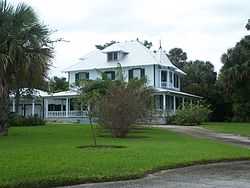
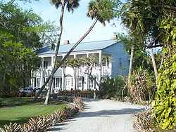
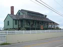
| 1 |
Burn Brae Plantation-Krueger House |
|
02002-02-14-0000February 14, 2002
(#02000002) |
1170 Southeast Ocean Boulevard
27°11′47″N 80°13′56″W / 27.196389°N 80.232222°W / 27.196389; -80.232222 (Burn Brae Plantation-Krueger House) |
Stuart |
NRHP# 02000002
|
| 2 |
Cypress Lodge |
|
02008-11-12-0000November 12, 2008
(#08001040) |
18681 SW Conners Highway
26°58′29″N 80°36′48″W / 26.974731°N 80.613231°W / 26.974731; -80.613231 (Cypress Lodge) |
Port Mayaca |
NRHP# 08001040
|
| 3 |
Gate House |
|
02001-11-21-0000November 21, 2001
(#01001246) |
214 South Beach Road
27°02′09″N 80°06′16″W / 27.035833°N 80.104444°W / 27.035833; -80.104444 (Gate House) |
Jupiter Island |
NRHP# 01001246
|
| 4 |
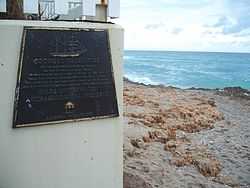
Georges Valentine Shipwreck Site |
|
02006-07-19-0000July 19, 2006
(#06000619) |
Offshore of the House of Refuge
27°11′55″N 80°09′47″W / 27.198611°N 80.163056°W / 27.198611; -80.163056 (Georges Valentine Shipwreck Site) |
Hutchinson Island |
NRHP# 06000619
|
| 5 |
House of Refuge at Gilbert's Bar |
|
01974-05-03-0000May 3, 1974
(#74000651) |
301 Southeast MacArthur Boulevard, south of Indian River Plantation and north of Bathtub Beach
27°11′57″N 80°09′56″W / 27.199167°N 80.165556°W / 27.199167; -80.165556 (House of Refuge at Gilbert's Bar) |
Hutchinson Island |
NRHP# 74000651
|
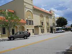
| 6 |
Lyric Theatre |
|
01993-11-12-0000November 12, 1993
(#93001204) |
59 Southwest Flagler Avenue
27°11′56″N 80°15′17″W / 27.198889°N 80.254722°W / 27.198889; -80.254722 (Lyric Theatre) |
Stuart |
NRHP# 93001204
|
| 7 |
Mount Elizabeth Archeological Site |
|
02002-09-14-0000September 14, 2002
(#02001011) |
1707 Northeast Indian River Drive
27°13′40″N 80°12′48″W / 27.227778°N 80.213333°W / 27.227778; -80.213333 (Mount Elizabeth Archeological Site) |
Jensen Beach |
NRHP# 02001011
|
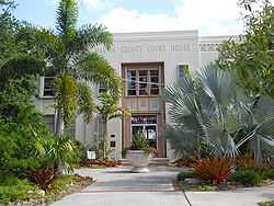
| 8 |
Old Martin County Courthouse |
|
01997-11-07-0000November 7, 1997
(#97001329) |
80 East Ocean Boulevard
27°12′02″N 80°14′44″W / 27.200556°N 80.245556°W / 27.200556; -80.245556 (Old Martin County Courthouse) |
Stuart |
NRHP# 97001329
|
| 9 |
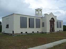
Olympia School |
|
02002-12-20-0000December 20, 2002
(#02001534) |
9141 Southeast Apollo St.
27°03′34″N 80°07′53″W / 27.059444°N 80.131389°W / 27.059444; -80.131389 (Olympia School) |
Hobe Sound |
NRHP# 02001534
|
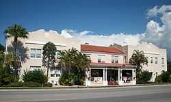
| 10 |
Seminole Inn |
|
02006-05-31-0000May 31, 2006
(#06000442) |
15885 Southwest Warfield Boulevard
27°01′27″N 80°28′10″W / 27.024167°N 80.469444°W / 27.024167; -80.469444 (Seminole Inn) |
Indiantown |
NRHP# 06000442
|
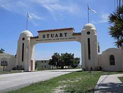
| 11 |
Stuart Welcome Arch |
|
02004-09-15-0000September 15, 2004
(#04000971) |
Between 2369 and 2390 Northeast Dixie Highway
27°13′31″N 80°13′13″W / 27.225278°N 80.220278°W / 27.225278; -80.220278 (Stuart Welcome Arch) |
Jensen Beach |
NRHP# 04000971
|
| 12 |
Trapper Nelson Zoo Historic District |
|
02006-10-03-0000October 3, 2006
(#06000918) |
16450 Southeast Federal Highway
26°58′37″N 80°09′49″W / 26.976944°N 80.163611°W / 26.976944; -80.163611 (Trapper Nelson Zoo Historic District) |
Hobe Sound |
NRHP# 06000918
|
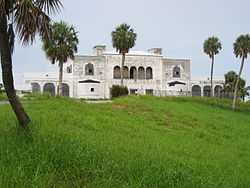
| 13 |
Tuckahoe |
|
02005-11-30-0000November 30, 2005
(#05001339) |
1921 Northeast Indian River Drive
27°13′41″N 80°12′48″W / 27.228056°N 80.213333°W / 27.228056; -80.213333 (Tuckahoe) |
Jensen Beach |
NRHP# 05001339 |
See also
References
- ↑ The latitude and longitude information provided in this table was derived originally from the National Register Information System, which has been found to be fairly accurate for about 99% of listings. For about 1% of NRIS original coordinates, experience has shown that one or both coordinates are typos or otherwise extremely far off; some corrections may have been made. A more subtle problem causes many locations to be off by up to 150 yards, depending on location in the country: most NRIS coordinates were derived from tracing out latitude and longitudes off of USGS topographical quadrant maps created under the North American Datum of 1927, which differs from the current, highly accurate WGS84 GPS system used by most on-line maps. Chicago is about right, but NRIS longitudes in Washington are higher by about 4.5 seconds, and are lower by about 2.0 seconds in Maine. Latitudes differ by about 1.0 second in Florida. Some locations in this table may have been corrected to current GPS standards.
- ↑ "National Register of Historic Places: Weekly List Actions". National Park Service, United States Department of the Interior. Retrieved on May 1, 2015.
- ↑ Numbers represent an ordering by significant words. Various colorings, defined here, differentiate National Historic Landmarks and historic districts from other NRHP buildings, structures, sites or objects.
- ↑ "National Register Information System". National Register of Historic Places. National Park Service. 2009-03-13.
- ↑ The eight-digit number below each date is the number assigned to each location in the National Register Information System database, which can be viewed by clicking the number.
|
|---|
| | Lists by county | | |
|---|
| | Lists by city | |
|---|
| | Other lists | |
|---|
| |
|