National Register of Historic Places listings in Marion County, Ohio

Location of Marion County in Ohio
This is a list of the National Register of Historic Places listings in Marion County, Ohio.
This is intended to be a complete list of the properties and districts on the National Register of Historic Places in Marion County, Ohio, United States. The locations of National Register properties and districts for which the latitude and longitude coordinates are included below, may be seen in a Google map.[1]
There are 14 properties and districts listed on the National Register in the county, including 1 National Historic Landmark.
- This National Park Service list is complete through NPS recent listings posted May 1, 2015.[2]
Current listings
| [3] |
Name on the Register[4] |
Image |
Date listed[5] |
Location |
City or town |
Description |
|---|
| 1 |
Bretz Farm |
|
01980-01-08-0000January 8, 1980
(#80003155) |
197 Morral-Kirkpatrick Rd., east of Morral
40°41′16″N 83°09′20″W / 40.687778°N 83.155556°W / 40.687778; -83.155556 (Bretz Farm) |
Grand Prairie Township |
|
| 2 |
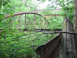
Caledonia Bowstring Bridge |
|
01978-05-23-0000May 23, 1978
(#78002131) |
North of Caledonia
40°38′33″N 82°57′55″W / 40.64245°N 82.96539°W / 40.64245; -82.96539 (Caledonia Bowstring Bridge) |
Claridon Township |
|
| 3 |
Harding Tomb |
|
01976-06-16-0000June 16, 1976
(#76001485) |
Marion Cemetery
40°34′23″N 83°07′23″W / 40.573056°N 83.123056°W / 40.573056; -83.123056 (Harding Tomb) |
Marion |
|
| 4 |
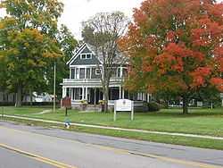
Warren G. Harding House |
|
01966-10-15-0000October 15, 1966
(#66000618) |
380 Mount Vernon Ave.
40°35′11″N 83°07′19″W / 40.586389°N 83.121944°W / 40.586389; -83.121944 (Warren G. Harding House) |
Marion |
|
| 5 |
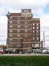
Hotel Harding |
|
01980-03-11-0000March 11, 1980
(#80003154) |
267 W. Center St.
40°35′17″N 83°08′00″W / 40.588056°N 83.133333°W / 40.588056; -83.133333 (Hotel Harding) |
Marion |
|
| 6 |
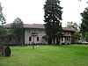
George W. King Mansion-Etowah |
|
01995-11-22-0000November 22, 1995
(#95001331) |
429 Mount Vernon Ave.
40°35′06″N 83°07′14″W / 40.585°N 83.120556°W / 40.585; -83.120556 (George W. King Mansion-Etowah) |
Marion |
|
| 7 |
Marion Cemetery Receiving Vault |
|
01995-12-13-0000December 13, 1995
(#95001415) |
620 Delaware Ave.
40°34′34″N 83°07′20″W / 40.576111°N 83.122222°W / 40.576111; -83.122222 (Marion Cemetery Receiving Vault) |
Marion |
|
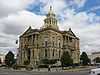
| 8 |
Marion County Courthouse |
|
01974-07-25-0000July 25, 1974
(#74001572) |
100 N. Main St.[6]
40°35′20″N 83°07′42″W / 40.5889°N 83.1283°W / 40.5889; -83.1283 (Marion County Courthouse) |
Marion |
|
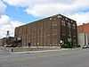
| 9 |
Marion County Telephone Company Building |
|
02007-04-12-0000April 12, 2007
(#07000298) |
197 S. Main St.
40°35′12″N 83°07′45″W / 40.586667°N 83.129167°W / 40.586667; -83.129167 (Marion County Telephone Company Building) |
Marion |
|
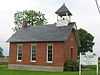
| 10 |
Marion Township Sub-District No. 8 School |
|
02007-02-07-0000February 7, 2007
(#07000027) |
2473 State Route 4 N., north of Marion
40°38′13″N 83°07′35″W / 40.636806°N 83.126389°W / 40.636806; -83.126389 (Marion Township Sub-District No. 8 School) |
Marion Township |
|
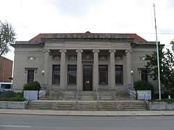
| 11 |
Old US Post Office |
|
01990-11-28-0000November 28, 1990
(#90001777) |
169 E. Church St.
40°35′14″N 83°07′32″W / 40.587222°N 83.125556°W / 40.587222; -83.125556 (Old US Post Office) |
Marion |
|
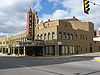
| 12 |
Palace Theatre |
|
01976-03-26-0000March 26, 1976
(#76001486) |
272 W. Center St.
40°35′19″N 83°08′01″W / 40.588611°N 83.133611°W / 40.588611; -83.133611 (Palace Theatre) |
Marion |
|
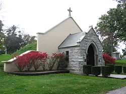
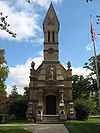
| 13 |
Soldiers' and Sailors' Memorial Chapel |
|
01995-03-09-0000March 9, 1995
(#95000169) |
Eastern side of State Route 423 within Marion Cemetery
40°34′40″N 83°07′28″W / 40.577639°N 83.124444°W / 40.577639; -83.124444 (Soldiers' and Sailors' Memorial Chapel) |
Marion |
|
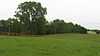
| 14 |
Wyatt's Tavern-Fort Morrow Site |
|
01978-12-22-0000December 22, 1978
(#78002132) |
Along the Olentangy River, 1 mile (1.6 km) north of Norton[7]
40°26′39″N 83°04′15″W / 40.4442°N 83.0708°W / 40.4442; -83.0708 (Wyatt's Tavern-Fort Morrow Site) |
Waldo Township |
|
See also
References
- ↑ The latitude and longitude information provided in this table was derived originally from the National Register Information System, which has been found to be fairly accurate for about 99% of listings. For about 1% of NRIS original coordinates, experience has shown that one or both coordinates are typos or otherwise extremely far off; some corrections may have been made. A more subtle problem causes many locations to be off by up to 150 yards, depending on location in the country: most NRIS coordinates were derived from tracing out latitude and longitudes off of USGS topographical quadrant maps created under the North American Datum of 1927, which differs from the current, highly accurate WGS84 GPS system used by most on-line maps. Chicago is about right, but NRIS longitudes in Washington are higher by about 4.5 seconds, and are lower by about 2.0 seconds in Maine. Latitudes differ by about 1.0 second in Florida. Some locations in this table may have been corrected to current GPS standards.
- ↑ "National Register of Historic Places: Weekly List Actions". National Park Service, United States Department of the Interior. Retrieved on May 1, 2015.
- ↑ Numbers represent an ordering by significant words. Various colorings, defined here, differentiate National Historic Landmarks and historic districts from other NRHP buildings, structures, sites or objects.
- ↑ "National Register Information System". National Register of Historic Places. National Park Service. 2009-03-13.
- ↑ The eight-digit number below each date is the number assigned to each location in the National Register Information System database, which can be viewed by clicking the number.
- ↑ Address derived from this Marion County webpage; the NRIS lists the courthouse on "Courthouse Square"
- ↑ Location derived from this county history; coordinates derived from the location of the Wyatt family cemetery on USGS topographical maps. The NRIS lists the site as "Address Restricted".
|
|---|
| | Lists by county | | |
|---|
| | Lists by city | |
|---|
| | Other lists | |
|---|
| |
|