| [3] |
Name on the Register[4] |
Image |
Date listed[5] |
Location |
City or town |
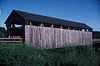
Description |
|---|
| 1 |
Chicago, Rock Island and Pacific Passenger Depot-Pella |
Upload image |
01991-07-22-0000July 22, 1991
(#91000909) |
Junction of Main and Oskaloosa Sts.
41°23′54″N 92°54′54″W / 41.398333°N 92.915°W / 41.398333; -92.915 (Chicago, Rock Island and Pacific Passenger Depot-Pella) |
Pella |
|
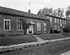
| 2 |
Coal Ridge Baptist Church and Cemetery |
Upload image |
02006-08-23-0000August 23, 2006
(#06000711) |
1034 Iowa Highway 71
41°22′41″N 93°01′15″W / 41.378056°N 93.020833°W / 41.378056; -93.020833 (Coal Ridge Baptist Church and Cemetery) |
Knoxville |
|
| 3 |
East Amsterman School |
Upload image |
02000-12-01-0000December 1, 2000
(#00001471) |
1010 198th Place
41°23′06″N 92°57′28″W / 41.385°N 92.957778°W / 41.385; -92.957778 (East Amsterman School) |
Pella |
|
| 4 |
Evan F. Ellis Farmhouse |
Upload image |
01985-01-03-0000January 3, 1985
(#85000006) |
Junction of Story and West Sts.
41°13′10″N 92°53′20″W / 41.219444°N 92.888889°W / 41.219444; -92.888889 (Evan F. Ellis Farmhouse) |
Bussey |
|
| 5 |
First Christian Church |
Upload image |
02007-03-29-0000March 29, 2007
(#07000206) |
824 Franklin St.
41°24′26″N 92°55′09″W / 41.407222°N 92.919167°W / 41.407222; -92.919167 (First Christian Church) |
Pella |
|
| 6 |
Hammond Bridge |
|
01998-05-15-0000May 15, 1998
(#98000500) |
170th Pl. over North Cedar Creek
41°10′39″N 93°00′50″W / 41.1775°N 93.013889°W / 41.1775; -93.013889 (Hammond Bridge) |
Hamilton |
|
| 7 |
Harvey Railroad Bridge |
Upload image |
01998-05-15-0000May 15, 1998
(#98000502) |
Harvey Island Rd.
41°19′02″N 92°54′36″W / 41.317222°N 92.91°W / 41.317222; -92.91 (Harvey Railroad Bridge) |
Harvey |
|
| 8 |
E.R. Hays House |
Upload image |
01984-09-27-0000September 27, 1984
(#84001283) |
301 N. 2nd St.
41°19′16″N 93°05′49″W / 41.321111°N 93.096944°W / 41.321111; -93.096944 (E.R. Hays House) |
Knoxville |
|
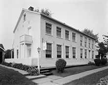
| 9 |
Knoxville Veterans Administration Hospital Historic District |
Upload image |
02012-05-01-0000May 1, 2012
(#12000246) |
1515 W. Pleasant St.
41°19′20″N 93°06′51″W / 41.322283°N 93.114068°W / 41.322283; -93.114068 (Knoxville Veterans Administration Hospital Historic District) |
Knoxville |
United States Second Generation Veterans Hospitals Multiple Property Submission
|
| 10 |
Knoxville WPA Athletic Field Historic District |
Upload image |
02007-08-02-0000August 2, 2007
(#07000775) |
Bounded by Lincoln St., Robinson St., Stadium St., and Marion St.
41°19′08″N 93°06′31″W / 41.318761°N 93.108617°W / 41.318761; -93.108617 (Knoxville WPA Athletic Field Historic District) |
Knoxville |
|
| 11 |
Philipus J. and Cornelia Koelman House |
Upload image |
02005-12-21-0000December 21, 2005
(#05001430) |
1005 Broadway St.
41°24′35″N 92°55′06″W / 41.409722°N 92.918333°W / 41.409722; -92.918333 (Philipus J. and Cornelia Koelman House) |
Pella |
|
| 12 |
Marion County Courthouse |
|
01981-07-02-0000July 2, 1981
(#81000256) |
Main St.
41°19′06″N 93°05′48″W / 41.318333°N 93.096667°W / 41.318333; -93.096667 (Marion County Courthouse) |
Knoxville |
|
| 13 |
Pella Opera House |
Upload image |
01992-03-20-0000March 20, 1992
(#91001080) |
611 Franklin St.
41°24′23″N 92°54′51″W / 41.406389°N 92.914167°W / 41.406389; -92.914167 (Pella Opera House) |
Pella |
|
| 14 |
People's National Bank |
Upload image |
02010-04-21-0000April 21, 2010
(#10000202) |
717 Main St.
41°24′20″N 92°54′59″W / 41.405633°N 92.916478°W / 41.405633; -92.916478 (People's National Bank) |
Pella |
|
| 15 |
Porter-Rhynsburger House |
Upload image |
02003-08-28-0000August 28, 2003
(#03000837) |
514 Broadway St.
41°24′14″N 92°55′06″W / 41.403889°N 92.918333°W / 41.403889; -92.918333 (Porter-Rhynsburger House) |
Pella |
|
| 16 |
St. Joseph's Roman Catholic Church and Cemetery Historic District |
Upload image |
01995-01-24-0000January 24, 1995
(#94001580) |
1 mile (1.6 km) east of the junction of County Road G76 and SE. 97th St.
41°12′12″N 93°18′29″W / 41.203333°N 93.308056°W / 41.203333; -93.308056 (St. Joseph's Roman Catholic Church and Cemetery Historic District) |
Lacona |
|
| 17 |
Dominie Henry P. Scholte House |
Upload image |
01982-12-10-0000December 10, 1982
(#82000415) |
739 Washington St.
41°24′30″N 92°55′02″W / 41.408333°N 92.917222°W / 41.408333; -92.917222 (Dominie Henry P. Scholte House) |
Pella |
|
| 18 |
Ten Hagen Cottage-Stegman Store |
Upload image |
02008-07-16-0000July 16, 2008
(#08000685) |
1110 W. Washington St.
41°24′29″N 92°55′25″W / 41.40812°N 92.92371°W / 41.40812; -92.92371 (Ten Hagen Cottage-Stegman Store) |
Pella |
|
| 19 |
Thomas F. and Nancy Tuttle House |
Upload image |
02015-01-27-0000January 27, 2015
(#14001209) |
608 Lincoln St.
41°24′39″N 92°54′55″W / 41.4107°N 92.9154°W / 41.4107; -92.9154 (Thomas F. and Nancy Tuttle House) |
Pella |
|
| 20 |
William Van Asch House-Huibert Debooy Commercial Room |
|
01987-12-02-0000December 2, 1987
(#87002056) |
1105, 1107, and 1109 W. Washington St.
41°24′28″N 92°55′27″W / 41.407778°N 92.924167°W / 41.407778; -92.924167 (William Van Asch House-Huibert Debooy Commercial Room) |
Pella |
|
| 21 |
Hendrik J. and Wilhelmina H. Van Den Berg Cottage |
Upload image |
02003-08-28-0000August 28, 2003
(#03000835) |
1305 W. Washington St.
41°24′14″N 92°55′42″W / 41.403889°N 92.928333°W / 41.403889; -92.928333 (Hendrik J. and Wilhelmina H. Van Den Berg Cottage) |
Pella |
|
| 22 |
Dirk Van Loon House |
Upload image |
01977-11-17-0000November 17, 1977
(#77000539) |
1401 University Ave.
41°24′02″N 92°55′33″W / 41.400556°N 92.925833°W / 41.400556; -92.925833 (Dirk Van Loon House) |
Pella |
|
| 23 |
Henry and Johanna Van Maren House-Diamond Filling Station |
Upload image |
02008-07-10-0000July 10, 2008
(#08000683) |
615 Main St.
41°24′15″N 92°54′59″W / 41.40428°N 92.91652°W / 41.40428; -92.91652 (Henry and Johanna Van Maren House-Diamond Filling Station) |
Pella |
|
| 24 |
B.H. and J.H.H. Van Spanckeren Row Houses |
|
01990-02-12-0000February 12, 1990
(#90000004) |
505-507 Franklin St.
41°24′08″N 92°54′30″W / 41.402222°N 92.908333°W / 41.402222; -92.908333 (B.H. and J.H.H. Van Spanckeren Row Houses) |
Pella |
|
| 25 |
Dirk and Cornelia J. Vander Wilt Cottage |
Upload image |
02001-08-08-0000August 8, 2001
(#01000856) |
925 Broadway St.
41°24′32″N 92°55′06″W / 41.408889°N 92.918333°W / 41.408889; -92.918333 (Dirk and Cornelia J. Vander Wilt Cottage) |
Pella |
|
| 26 |
Wabash Railroad Bridge |
Upload image |
01998-05-15-0000May 15, 1998
(#98000501) |
216th Pl. over the Des Moines River
41°20′26″N 92°56′25″W / 41.340556°N 92.940278°W / 41.340556; -92.940278 (Wabash Railroad Bridge) |
Pella |
|